


Spirits in Stone

Lost Knowledge of the Ancients

Mysteries of the Ancient Past

Archaeoacoustics

It is with pleasure that we welcome our Author of the Month for November, Glenn Kreisberg, and his latest book on the landscape archaeology and archaeoastronomy of the backwoods of northeast North America.
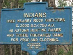
Presenting a comprehensive field guide to hundreds of lost, forgotten, and misidentified megalithic stone structures, Kreisberg documents enigmatic formations still standing across the Catskill Mountain and Hudson Valley region, complete with functioning solstice and equinox alignments.
“Kreisberg’s work will contribute greatly to demonstrating the fact that not only did Native Americans construct impressive stone structures throughout the eastern United States but that these sites are sacred and an integral part of their cultural traditions and should be protected!”
– Harry Holstein, Professor of Archaeology at Jacksonville State University, Alabama
My new book, Spirits in Stone, was published in April 2018, by Bear & Co. In it I document over a decade of research into man-made stone constructions in the backwoods of the northeast, with a focus on the Hudson Valley, Catskill and Shawangunk Mountains of New York. I examine the potential origins and purposes of a myriad of different types of old stone structures found on the land, including walls, cairns, perched boulders, effigies and more. I also examine important sites around the world for insights into ancient megalithic cultures.
In the northeast US, as elsewhere, the patterns revealed through the eye of landscape archaeology and archaeoastronomy speak to the sophisticated belief system of an ancient population that understood the complex movements of the night sky and integrated those beliefs into their lives and world view. I believe they accomplished this through the cultural practice of celestial observation, landscape manipulation and monument construction, as well as through travel and contact with peoples from other regions and parts of the world. This is not accepted to be true by conventional historians of the American northeast. For example, according to Herbert Kraft in his 2001 book, The Lenape-Delaware Indian Heritage 10,000 BC to AD 2000:
“There is absolutely no proof that man made megaliths, or dolmens, with or without grave objects, or any other manifestation of old world funerary construction or astronomical alignments, existed in Lenapehoking, or in the Northeast. The burden of proof is on those who make these claims, and thus far, every claim has been unsupported by satisfactory scientific evidence”.
I hope my book will help change this view.
This article documents several sites in the Hudson Valley, Shawangunk and Catskill Mountains of New York state, which display aspects, elements and features consistent with the practice of observational astronomy. Sites consist of “artefacts” found on the natural landscape or landscape features, such as large, set up boulders or prominent points of land, recognised or configured in such a way as to align with and/or point the way to an object or event in the sky or on the horizon.
Making the Case
Does evidence exist to support the theory that an ancient cultural group in our region used the natural environment and features found in the landscape to create celestial observation sites? Did they do this to track the movement of the Sun for practical purposes and as an expression of their cultural belief system?
We can use an observational astronomical temporal predictive model to determine the likelihood that this cultural practice was part of the Native American belief system.
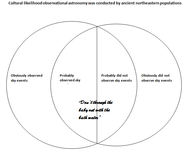
By use of this model we ask: is it likely or unlikely that an ancient population in northeast America watched the sky and took note of the solstices and equinoxes? And, is it likely or unlikely that they marked the Sun during those times of year in some way? If evidence exists, and supports the case that sky events were observed, then it’s logical to conclude that the positions were preserved in some way. Asking how this might be accomplished is a reasonable question. We might also ask: If it did occur in northeast America, how would this cultural practice compare to other regions of North and South America?
For the past ten years I have used the GIS approach to identifying and researching potential ceremonial stone landscapes (CSL) in our region, documenting sites consisting of cairn fields, perched boulders, stone walls, standing stones and stone effigies. Using GPS, I have plotted the site locations and created a database of site types and associated features, to discern patterns of concentration and distribution over geographic areas. One pattern that has emerged is the large number of site locations that align with other sites at an azimuth that matches the angle of the Summer and Winter Solstice sunrise and sunset.

Database of sites and features found in the Hudson Valley, Shawangunk and Catskill Mountains
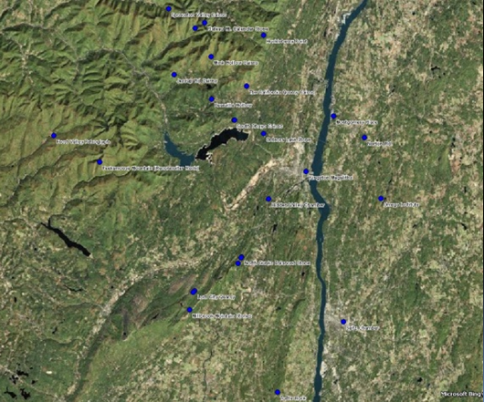
Stone site locations in the Hudson Valley and Catskill Mountains. Image courtesy Google Earth

Hudson Valley and Catskill Mountains site locations showing azimuth lines connecting sites.
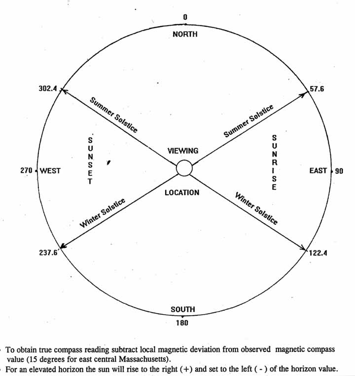
Above is a solstice chart provided by Archaeology Prof. Curtis Hoffman, UMASS Bridgewater. Our location in the Hudson Valley has similar azimuth angles and similar local magnetic deviation to Professor Hoffman’s region in Bridgewater, MA, due to its similar latitude north of the Equator. Being a little further west than Bridgewater, MA, our magnetic deviation is slightly smaller, at +14.25 degrees from true, rather than +15 degrees from true. This chart is used to compare the solstice sunrise and sunset azimuths in both regions.
Paleo-times in the region
What would the first arrivals to the Hudson Valley and Catskills region have found? How would things have looked through their eyes? Early inhabitants and travellers to the region would have found a similar topography and familiar contours to what we see today, with the exception of the flora and fauna. For one thing, post glacial soil deposits would have been significant, placing a fresh, deep layer of rich soil upon the land from which the glaciers were receding. This post glacial soil has since eroded and been washed away from the mountains and upland slopes down into the valley floors, dropping and tumbling rocks, stones and boulders along the way, which still litter the ground and forest floors today. For a period of a few thousand years after the glaciers left, there would have been large deposits of nutrient rich soil for early human arrivals to exploit. This is based on my knowledge of local Catskill Mountain geology, which has been confirmed by discussions with experts such as Catskills geologist and author Robert Titus.
Those early paleo “settlers” were no doubt master survivalists, intimate with nature’s bounty, who knew how to successfully live off the land. From wherever they came (most probably a sophisticated maritime culture in the east), they would have brought with them the best knowledge, methods and practices developed and passed down for thousands of years. Among those things brought from other regions of the world and/or encountered or developed along the way would have been a belief system containing universal elements found worldwide in most paleo cultures. These would have included worship of fertility or the Goddess, and worship of the Sun. The earliest human holidays (holy days) were pagan celebrations of the solstices which were explicitly connected with fertility, birth, rebirth and the creation of life.
According to researchers of the history of reproduction and fertility like Zohreh Behjati-Ardakani and Mohammad Mehdi Akhondi, symbols of fertility in ancient mythology have a history as long as creation myths. Sun worship was just as ubiquitous, if not more so, in early human religion. Also brought with them would have been a tradition found common among the earliest cultures identified worldwide—building with stone, which was one of the first things humans did. As well as tools, prehistoric humans built expressive, monumental or ceremonial structures with stone, to represent belief systems and perhaps incorporate elements of Goddess and Sun worship. Many such constructions—from the temples of Malta and Egypt to the sarsens of Stonehenge—are testament to this. Building with stone is considered one of the oldest, most important activities of early humans, and there’s no reason to believe this was not also done by prehistoric northeast North Americans.
I believe that along the summits and ridge lines of the Shawangunk and Catskill Mountains are several examples of such possible ceremonial stone monuments, perhaps established by the earliest inhabitants of the region to express their spiritual practices involving fertility and the Sun. Examples consist of large boulders, set up and oriented in such a way as to align with the cardinal directions as well as events in the sky, on the horizon. These can be considered both “compass” stones and “calendar” stones, and are similar to other such stone constructions found across the globe.
As well as the practical purpose of marking the seasons over time and pointing the way north, south, east and west, many such sites may also possess symbolic aspects that manifest as light phenomenon, which appear on specific days of the year. At the solstice or equinox, for instance, light shafts are directed to portals where visual representations can occur. Examples include caves, caverns or chambers (all womb-like spaces) into which the rising or setting Sun shines. Likewise, large boulders or dolmens can be set up and configured in such a way so that the supporting base stones have gaps or windows through which the Sun’s rays shine on a particular day. In some cases, “dolmens” or large manipulated boulders are aligned over great distances with other, similar sites, created by those that shared a common ceremonial practice and spiritual belief, creating vast ceremonial stone landscapes.
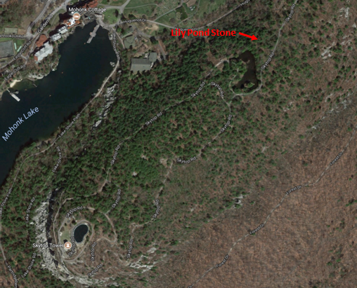
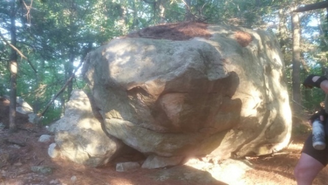
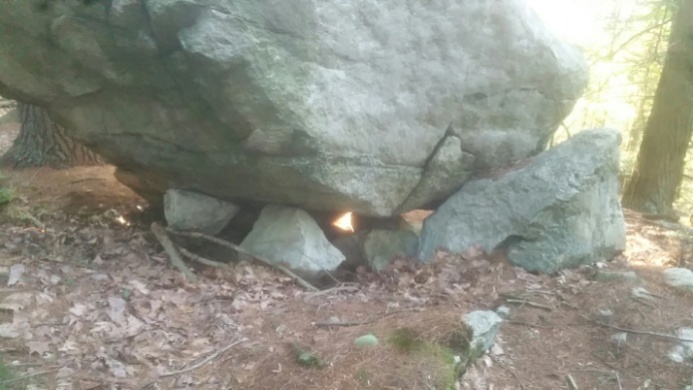
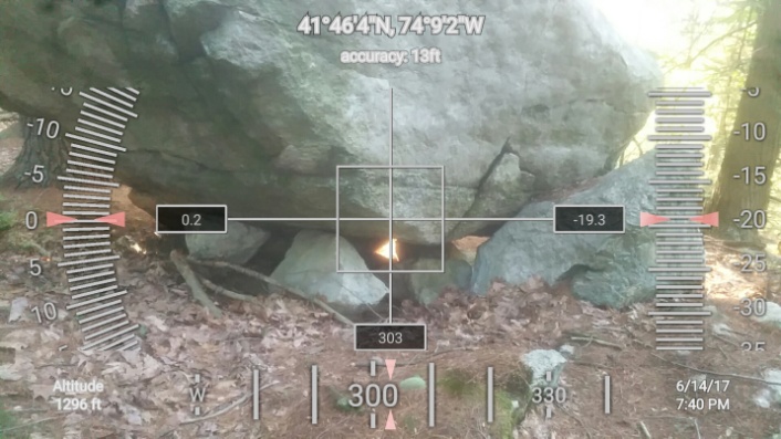
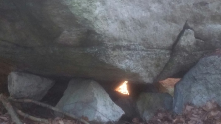
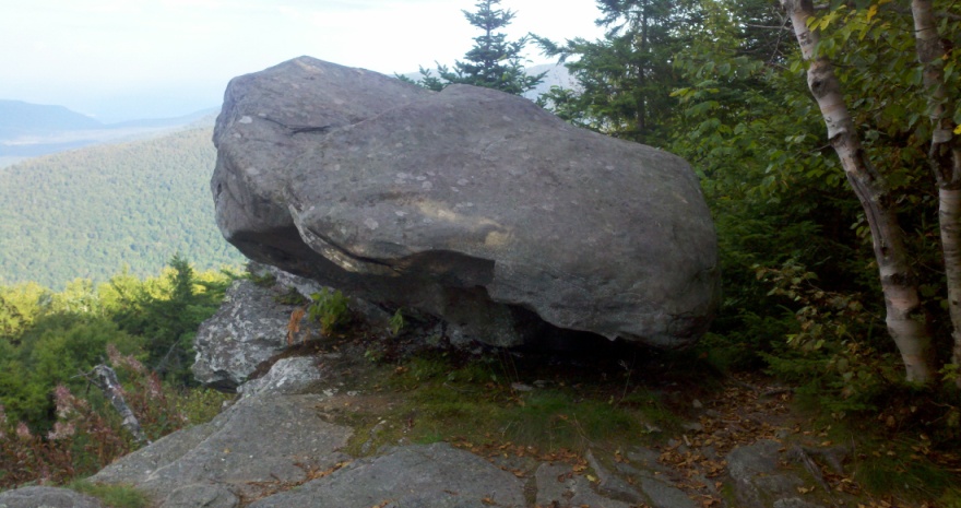
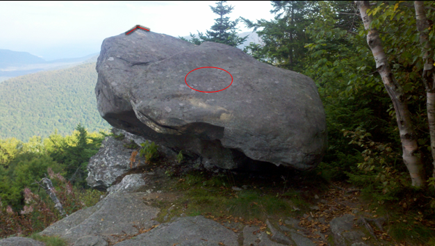
The Lily Pond Stone
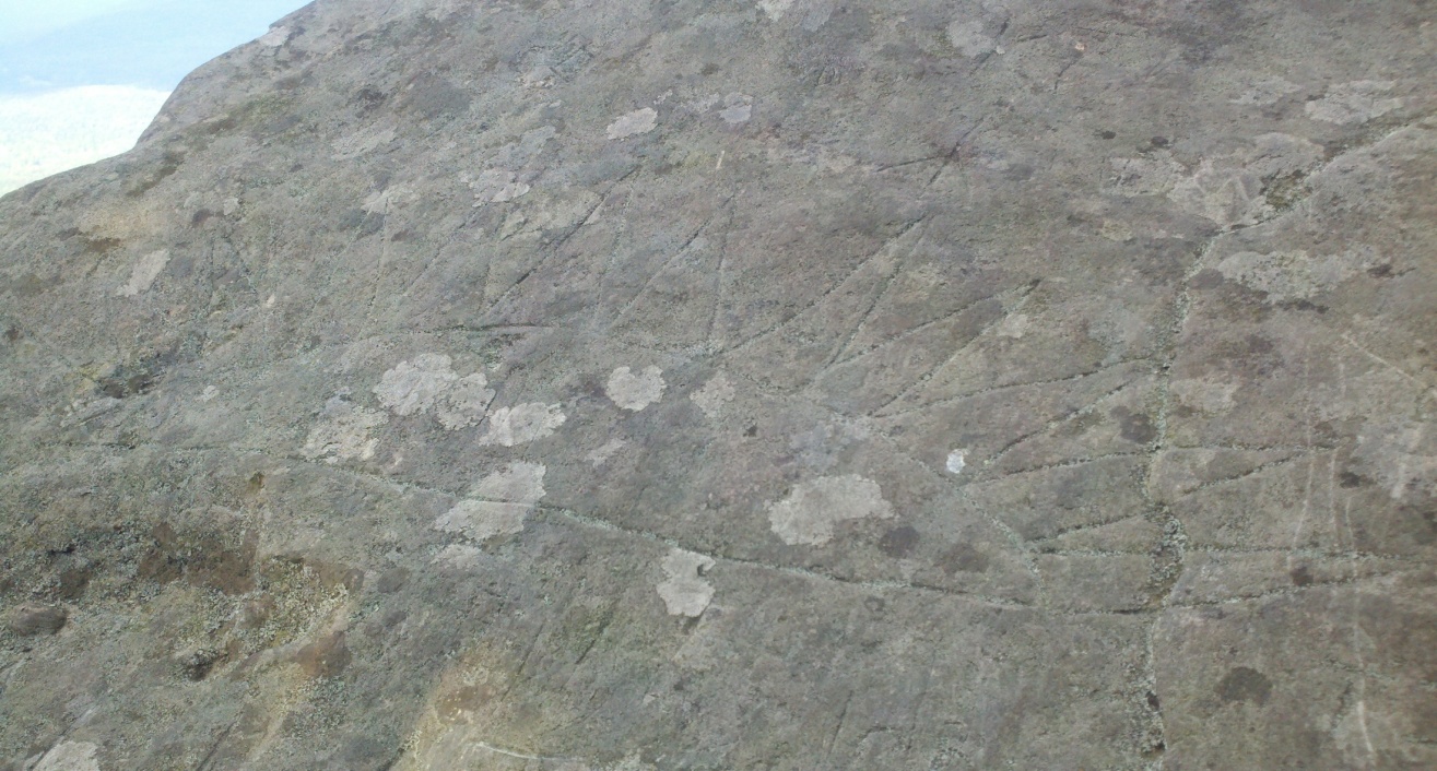
The Lily Pond stone, found atop Skytop in the Shawangunk Mountains, exhibits many of the aforesaid attributes. This perhaps twenty ton boulder has a nose pointing west that resembles the head of a turtle. Two other “noses” of this boulder point north and east, with a smooth face looking south. A shaft of light is captured beneath this large boulder set on three base stones. The beams projected beneath the boulder form a nearly perfect equilateral triangle shape of light at sunset, on the day of the Summer Solstice only. The triangle light form is seen at the base of the boulder when viewed from the east side and is projected with one point up and two points down. To some, this could be interpreted as the tanit symbol (an equal sided triangle, one point up, two points down), considered by many an ancient symbol of the sacred feminine, fertility and the goddess deity. That the light phenomenon only occurs on the eve of the Summer Solstice ties the two beliefs together in a sacred conjunction of sky, earth and birth.

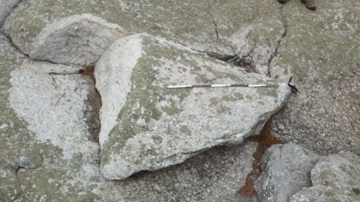
Bonticou Summer Solstice Sunrise Stone
Moving north and east from Skytop to Bonticou Crag summit 2.2 miles away, we find another stone moved by humans sometime in the past, in order to create an alignment with the rising Sun on the horizon on the Summer Solstice. This small, perhaps 500 lbs. triangular boulder was shifted into its position in the bedrock so that it points to a prominent point approximately 57 degrees from true north, the angle toward the Summer Solstice sunrise. The site location is on a level summit that is not susceptible to landslides or the force of gravity, so it is unlikely that nature moved this rock—it would have taken something like an earthquake to do so and the region experiences minimal seismic activity. The pattern and alignment of lichen growth on the boulder also indicates the stone was not shifted by glacial activity, as visually, you can tell the lichen growth occurred before the stone was shifted from its original position in the bedrock and sometime after the glaciers receded. We are therefore led to believe that it must have been moved for some purpose that fits with and expresses a human cultural belief system. Someone wanted it moved for a reason—practical or otherwise.

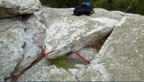
High Peterskill Dolmen
Next is the High Peterskill Dolmen, also located atop the Shawangunk Ridge a few miles south of Skytop. Though not as large as the North “Gunks” Dolmen or the Lily Pond Stone, this propped boulder also has noses aligned to north, south and west on the compass. Its exposed ridge-top summit location provides expansive views in all directions—Skytop is clearly visible to the north, the Catskills are visible to the west, and the Hudson Highlands (including Bear Mountain) are visible to the south. I am yet to investigate whether light phenomena are associated with this stone. However, the base stones are organised in such a way as to create small ports or windows through which the Sun could shine. In fact, I found this stone whilst hiking on a roughly marked trail through a narrow east/west pass in the ridge and happened to notice the Sun shining through an opening from what looked like the underside of a large stone on a nearby ridgeline. A few minutes of bushwhacking uphill brought me to the High Petterskill “Dolmen”.
Photos or site visits of all of the stones discussed in this article would most likely elicit a predictable response from geologists: there is nothing seen here that could not have occurred or been caused by forces of nature. My answer to them is in the same regard: there is nothing seen here that could not have occurred or been caused by the action of humans.
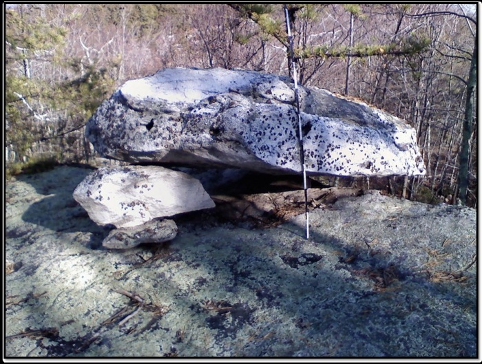
North “Gunks” Dolmen/Peekamoose Alignment
This alignment consists of two large boulders. One is a perched or balanced rock comprised of Catskill greywacke shale sandstone, known as Reconnoiter Rock on Peekamoose Mountain, deep in the Catskill Mountains; the other is a large quartzite conglomerate boulder set on three base stones (a dolmen) located on a summit ridge in the northern Shawangunk range.
Both large boulders have obvious aspects that appear to align with the four cardinal directions.
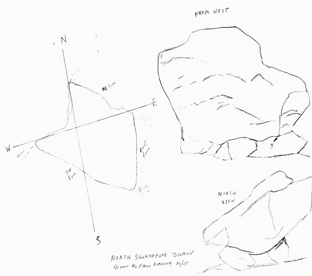
The author’s drawing of North Shawangunk Dolmen in the Shawangunk Mountains of New York
Both large boulders, located 18.5 miles apart, are visible in each other’s line of site.
Both site locations share and are located along the same Winter Solstice sunrise/Summer Solstice sunset alignment of 303 degrees NW and 123 degrees SW from true north.
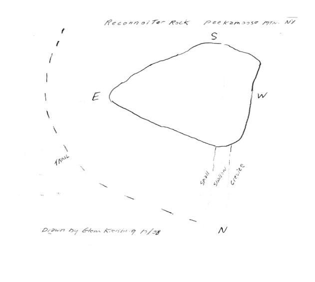
The author’s drawing of Reconnoiter Rockon Peekamoose Mountain in the Catskills
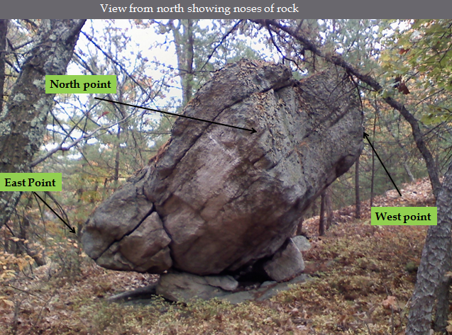
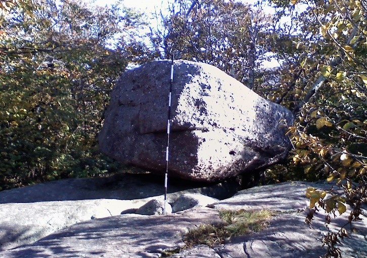
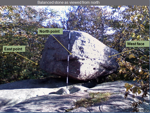
The North Shawangunk Dolmen, located about a mile north of Bonticou Crag on the Mohonk Preserve, is at an elevation of 841’. It is a perched rock set on three stones, making it a dolmen. The large boulder (perhaps 20+ tons) appears set at an extreme angle, deeming it unlikely to have been dropped from a receding glacier. Again, we are left with the possibility that human interaction and manipulation were at force here.
The large rock is found on the ridge top summit with views of the Hudson Valley to the east and the Catskill Mountains to the west. This large perched or balanced boulder has no known name, but it could be called Compass Rock, as it appears to have features oriented to the 4 cardinal directions.
It aligns with the Peekamoose Mtn. (Reconnoiter Rock) site at 303 degrees NW for a Summer Solstice sunset alignment.
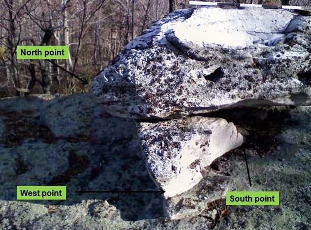
The roughly triangular shaped glacial erratic, perched on three set points, has corners or noses pointing north, west and south. It has a face that faces east.
North Shawangunk Dolmen on the Mohonk Preserve, Ulster CO, NY

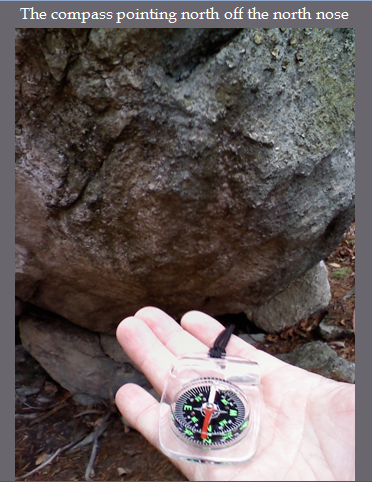
Compass showing west and north aspect of two of the “noses.”
The Peekamoose Mountain Perched Rock, at an elevation of 3503’, is also known as Reconnoiter Rock on the DEC map and is located at the summit of a shoulder just south and slightly west of Peekamoose Mountain summit. The location has prominent views to the south, west and east, toward the Shawangunk ridge.
This large perched or balanced boulder (at perhaps 10+ tons) could also be called Compass Rock as it also appears oriented to the 4 cardinal directions.
It aligns with the North Shawangunk Dolmen for the Winter Solstice sunrise. The roughly triangular shaped glacial erratic, perched or balanced on a single point, has corners or noses pointing north, east and south.
Reconnoiter Rock in the Catskill Mountains
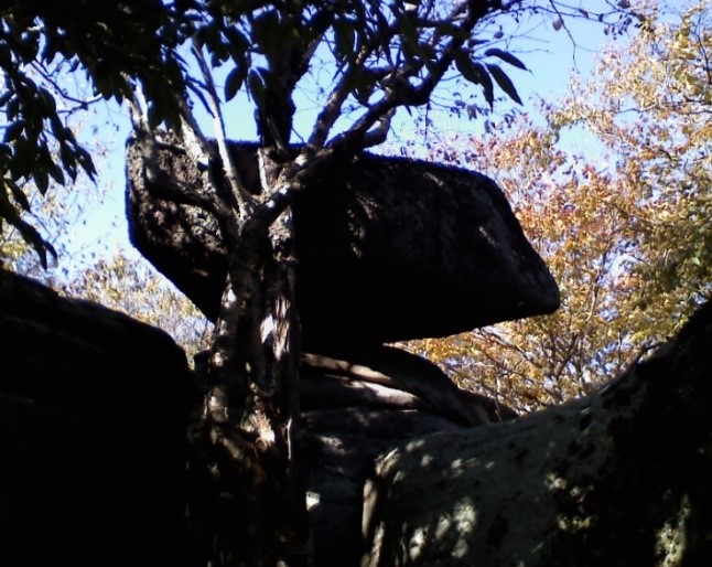
In profile there is an avian aspect to the rock
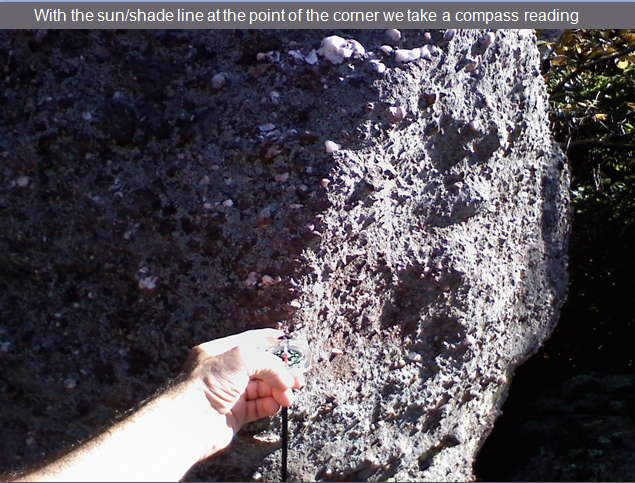
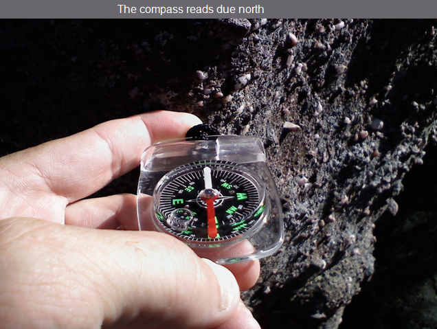
Sun/shade line on north point Compass on Sun/shade line points due north
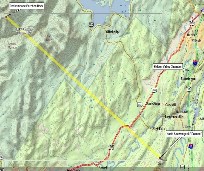
The Peekamoose/Shawangunk Alignment 318 deg. mag. Delorme 3D mapping software, 2007
With the Peekamoose and Shawangunk “compass” rocks aligned to produce a solstice alignment, I checked if there was line of site between the two locations. Profiling the two locations shows that they could be seen from one another about 18.5 miles apart. It is possible that large predawn fires lit at both locations would be visible to each other, under the right conditions.

Terrain path profile between North “Gunks” Dolmen and Reconnoiter Rock on Peekamoose Mtn. 18.5 miles east. Image courtesy Delorme 3D mapping software
Is there a connection between these two site locations? Is this alignment simply coincidental or is it evidence that a cultural group once inhabited this region and used the landscape and horizon to establish, create and preserve astronomic alignments and monuments or calendar sites based on observation of the sky and celestial events? This possibility should not be dismissed without further research.
Plateau Mountain Calendar Stones
“Calendar” stones are set up so that features and aspects related to their locations and positionings also relate to an event on the horizon like a sunrise or sunset, or a particular day or days of the year, such as a solstice or equinox. Two such calendar stones have been identified on Plateau Mountain above the narrow valley floor of Stony Clove, where we find the Devil’s Tombstone megalith. Up a very steep mountain trail to the east, the first stone is found along the trail, less than a mile up. This stone was first reported to the New England Antiquities Research Association (NEARA) by Gary Jaycox in 1981. Jaycox documented 4 sighting lines directed toward the western horizon, including 303 degrees true, aligning with the Summer Solstice sunset to the northwest.
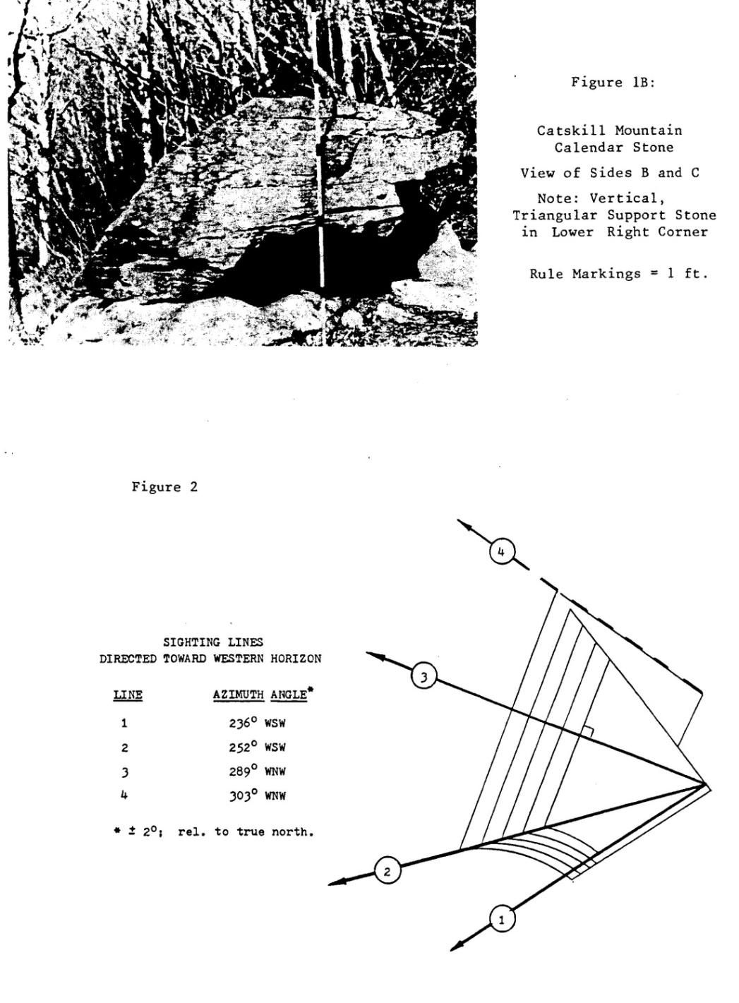
Catskill Mountain Calendar Stone identified by Jay Wilcox in 1981 on Plateau Mountain. From NEARA Journal
Less than a half mile further on the same trail, after reaching a western summit lookout and traversing across the summit a short distance to the southeast and another prominent overlook, we find a second boulder pointing to the Winter Solstice sunrise at approximately 123 degrees true (136 deg. magnetic). This second “calendar” stone is inscribed with a Sun glyph.
Plateau Mountain Winter Solstice Sunrise Stone
Plateau Mountain Winter Solstice Sunrise Stone showing location of Sun glyph and direction to the Winter Solstice sunrise position on horizon.
I believe the inscription may be old and certainly predates the DEC hiking trails in the area, which date to the early twentieth century. It is most likely that before the trail was established, very few European settlers would have come to this spot. The glyph would have marked this location and boulder as being an important spot for observing the Winter Solstice sunrise.
Close up of Sun glyph
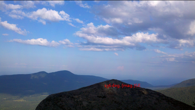
Prominent point oriented toward the Winter Solstice sunrise position
Sites such as the Plateau Mountain “calendar” stones seem to indicate observational astronomy was carried out and its information preserved by manipulating the natural terrain to create alignments between the horizon, landscape features and manmade monuments.
Overlook Mountain/Draco Correlation
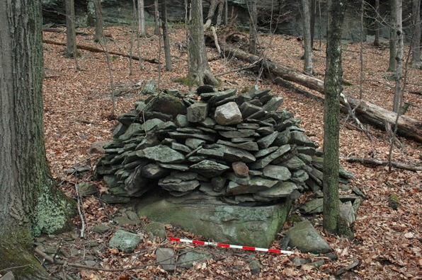
Located in upper Lewis Hollow on Overlook Mountain in Woodstock, NY, are a set of well organised stone constructions consisting of carefully constructed stone piles (cairns), stone walls, serpent or shale effigy walls and “great” cairns, covering a nearly 40 acre plot of land. There are several dozen smaller cairns of between 1 to 3 meters in height and width scattered over the mountainside, which is 1100-1400ft above mean sea level.
There are six “great” cairns between 60 and 100 ft in length and up to 4 meters in height. There are 2 curving snake “effigy” walls 90ft in length, located at the highest elevation, above the cairns and constructed tail to tail, with heads facing away. There are two springs located at the lowest elevation of the site. In 2006, New York State Museum GIS Specialist Susan Winchell Sweeney conducted a GPS survey of the site. She plotted and documented the location of each of the features present and produced the following map.
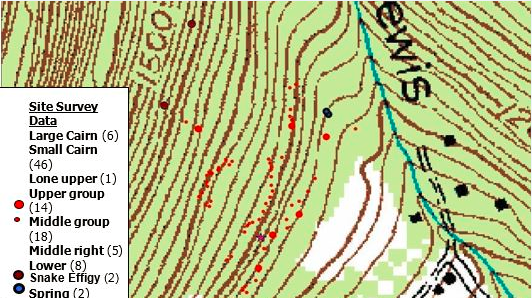
When I first saw the map that Susan Sweeney created, I noticed the clusters of small cairns lined up in crescent rows. After some time, I began to focus on the locations of the 6 large “great” cairns and the two “snake” effigy walls identified on the map. When I isolated the 8 large stone constructions (all between 60 and 90ft in length) and connected the dots for those locations, what I found was an “S” pattern.
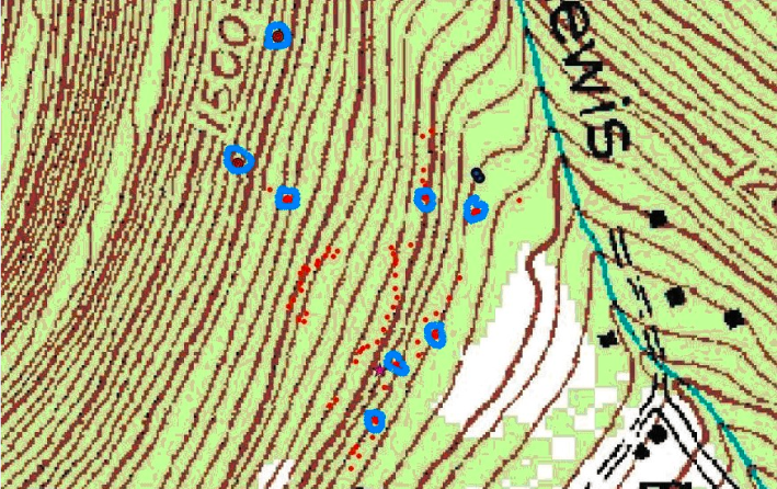
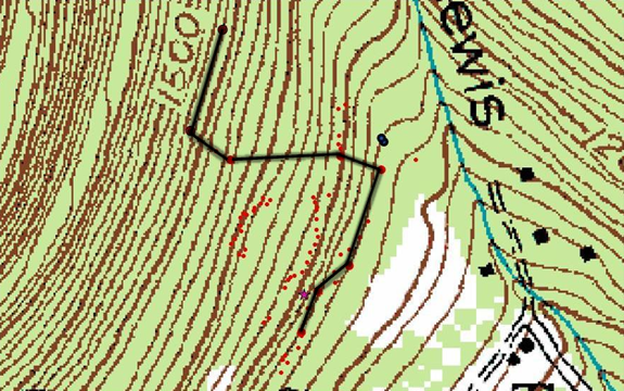
Stone construction locations on Overlook Mountain form an “S” pattern on the mountainside
On the possibility that the pattern could be a star map, I compared the pattern on the mountain to constellations in the northern hemisphere. The circumpolar constellation Draco quickly emerged as a close match. Then, using the ground coordinates of the site and utilising the astronomy software program Starry Night Pro, I discovered that Draco appeared in the sky above the coordinates of the Overlook Mountain site.

Star chart of the northern hemisphere showing Draco, the serpent of snake constellation
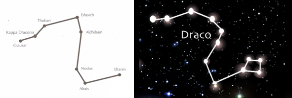
Comparing the “petroform” on Overlook Mountain with the constellation Draco
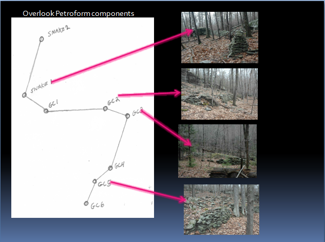
Image showing the large stone constructions on Overlook Mountain that make up the Draco “petroform” (a purposefully built stone construction, taking the form of a human, animal, geometric or symbolic shape). As above, so below; the evidence speaks for itself.
Did Overlook Mountain once serve as a beacon for celestial north, to those living in its view-shed?
Danskammer Point on the Hudson River
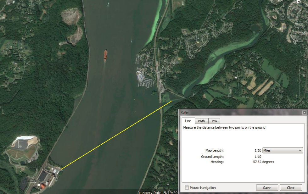
Danskammer Point on the Hudson River was a sacred location for the native tribes that belonged to the Wappinger Confederacy at the first time of contact with Europeans. Calvinist Dutch settlers like Henry Hudson believed that the natives practiced Devil worship and named the point of land on the Hudson River the ‘Devil’s Dance Chamber’ after a ceremony they witnessed as they sailed pass there. Using Google Earth, I determined a relationship between Danskammer Point and the mouth of the Wappinger’s Creek, across the river and slightly north.

Google Maps image showing location of Danskammer Point and the mouth of Wappinger’s Creek
Using Google Earth I plotted a line from Danskammer Point to the mouth of the Wappinger’s creek and determined the azimuth to be 57.62 degrees, as shown in the image below. This bearing is very close to the expected azimuth on the horizon where the Sun would rise on the Summer Solstice. Using the horizon perspective on Google Earth and the time bar, I was able to show the position of the Sun at the time of the sunrise on the solstice, relative to Danskammer Point and the mouth of Wappinger’s Creek, confirming the location as a viewpoint for observing the Summer Solstice sunrise, from the point of land, over the mouth of the creek across the river.
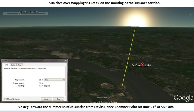
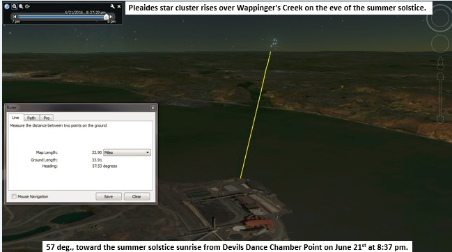
Google Earth image showing a Summer Solstice sunrise over the mouth of Wappinger’s Creek, as seen from Danskammer Point. During the night of the Summer Solstice, Google Earth shows the rise of the Pleiades star cluster in the same position on the horizon as the Summer Solstice sunrise. The position of the rise of the Pleiades throughout the year appears in the vicinity of where the Sun rises on the Summer Solstice. This is intriguing because research has documented an interest in the Pleiades among the Algonquin speaking tribes of the northeast (Ceci, 1978).
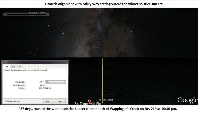
If we look at the reciprocal of the Summer Solstice alignment, and view Danskammer Point from the mouth of the Wappinger’s Creek on the Winter Solstice, we see an alignment with the setting Sun on the shortest day of the year, as shown in the Google Earth image below. And then, later in the evening, we see an alignment with the Galactic plane as the Milky Way sets, aligned with the position on the horizon where the Winter Solstice Sun sets, also shown below. Could all this explain why Danskammer Point and the mouth of the Wappinger’s Creek was the political and spiritual centre of the Wappinger confederacy? Were the keen skywatchers of their society aware of the relationship between the prominent point of land on the river, the mouth of the creek and the rising and setting solstice Sun in conjunction with the Pleiades and Milky Way?

Landscapes and Skyscapes
According to Professor Gary Urton, Chair of Anthropology at Harvard University, a “landscape” is defined as reflecting a living synthesis between humans and the land they encounter and a “skyscape” includes a portion of the sky or horizon, from which a cultural picture can be constructed. In his book At the Crossroads of Earth and Sky (1981), Urton documents how complex and sophisticated Native American cosmologies included observing, recognising and preserving alignments such as the Summer Solstice Sunrise in conjunction with position of the rise of Pleiades. Urton also shows that these cosmologies incorporate the galactic plane, or Milky Way, into their belief system, as a guiding force or pathway connecting the Living World with the Sky World.
Conclusion
More and more evidence is accumulating to support the case for prehistoric observation-based astronomical alignments in northeast America. Some recent research on ceremonial stone landscapes (CSL) was presented at the Stars and Stones Symposium held in December 2014 at Colgate University, hosted by Dr. Laurie Rush and Dr. Anthony Avini.
Are such alignments man made or natural? The answer is both, as all are made from elements found present in the environment and on the natural landscape, representing what I call landscape astronomy. In many cases humans may have manipulated such sites to make then functional. As we examine site locations and relationships, a clear pattern is emerging. The pattern revealing itself reflects landscapes and “skyscapes” that perhaps contain cultural stories. This pattern is beginning to be documented by a scientific methodology, building the case for observational astronomy occurring in northeast America in ancient times.
The evidence is hard to ignore and demands a closer look. As William Romain stated, “It’s clear to me that northeastern America has been totally and inappropriately marginalised by the mainstream. The Northeast US is right up there with the Southwest, Midwest, Effigy Mounds, Lower Mississippi Valley, and other traditions in terms of archaeoastronomical alignments, sensitivity to landscape features, and cosmological understandings.”
References
All photos and images are courtesy of the author unless otherwise noted.
Maps and map images are courtesy of Delorme mapping software, Google Earth and Google Maps.
Ceci, Lynn. 1978. “Watchers of the Pleiades: Ethnoastronomy among Native Cultivators of Northeastern North America.” Ethnohistory 25, no. 4 (Autumn): 301–17.
Jaycox, Gary, “Catskill Mountain Calendar Discovery” NEARA Journal 16, no. 2 (Fall 1981).
Kraft, Herbert. 2001. The Lenape-Delaware Indian Heritage 10,000 BC to AD 2000. Lenape Books (p.36).
Holstein, Harry. Professor of Archaeology, Jacksonville State University, Jacksonville, AL, 1/11/13 and 1/22/13, in personal correspondence by email. “There is probably some type of intentional alignment; placements within and between sites driven by solstices and other sky related events. I’m certain there is some very similar Sacred Native American Pan Appalachian cultural thought processes occurring over a wide area on both sides of this mountain range.”
Romain, William, Ph.D research associate, Ohio State University, 4/29/13 in personal correspondence by email.“It’s clear to me that the NE has been totally and inappropriately marginalized by the mainstream. The Northeast US is right up there with the Southwest, Midwest, Effigy Mounds, Lower Mississippi Valley, and other traditions in terms of archaeoastronomical alignments, sensitivity to landscape features, and cosmological understandings.”
Urton, Gary. 1981. At the Crossroads of Earth and Sky. Austin: University of Texas Press.
Zohreh Behjati-Ardakani, Mohammad Mehdi Akhondi, Homa Mahmoodzadeh, Seyed Hasan Hosseini. J Reprod Infertil. ‘An Evaluation of the Historical Importance of Fertility and Its Reflection in Ancient Mythology‘. Journal of Reproduction & Infertility, 2016 Jan-Mar; 17(1): 2–9.
About the author
Glenn Kreisberg is an author, outdoor guide and radio engineer researching archaeoastronomy and landscape archaeology in the Hudson Valley and the Catskill Mountains of New York. His books include Mysteries of the Ancient Past, Lost Knowledge of the Ancients and Spirits in Stone. He served two terms as vice president of the Northeast Antiquities Research Association and has studies archaeoastronomy at SUNY and archaeoacoustics on Malta. He is co-founder of the Overlook Mountain Center and lives in Woodstock, NY with his wife and two teenage children, a dog, three cats, a lizard, a bird and two fish.
As above, so below; something came before…
I agree with your research however why would people who are supposed to be hunter gatherers be so interested in where the sun rises ect.Unless there is a very good reason and I believe they were aware of ancient stories of the terrible destruction.If the earth had moved and had taken on a wobble like the path of a snake through space.I believe that if the sun did not rise at those points at those moment then maybe the earth was moving away from its orbit.
It’s actually a misnomer that they were all hunter gatherers. In many locations where land and water travel corridors converged and offered ready access to sustainable resources, large, permanent habitation area were established which may have remained occupied from paleo-times up through European contact. Population center, if you will, where spiritual, educational, agricultural and commerce activity took place. All the hallmarks of civilization.
You know it as ‘The Papyrus of Hunefer’, but they called it the inception & completion of the marriage of time & light. Osiris could not sit on his throne until it was complete.
https://twitter.com/Nephthy14216684
I am not an expert in any of these subjects just a fascinated follower and admirer of people like Glenn.
People right up to the present day, who live in towns and villages ( I live in England but I think it is more so in US) are as much hunter/ gatherers as those who came before us. People continue to hunt fish and game and gather herbs, mushrooms etc.
Sometimes I think people really mean ‘nomadic’ as in moving from place to place without a central home.
Bushmen of the Kalahari have areas they move to at different times of year but always return to those places.
The Caribbean Plate is ancient comet impact crater.
NASA comet Shoemaker-Levy 09 simulations, plasma coma shell cutaway, reveals exact coastlines & sea floor formations, ALL align when laid over GoogleEarth.
The current city locations of Trinidad, Venezuela, Colombia, Panama, Costa Rica, Nicaragua, Belize, Mexico, Yucatan, Cuba, Jamaica, Haiti, DR, Puerto Rico & St. Croix, Florida & the Keys can be lifted from a flat map & plotted onto the comet simulation & will align to the positive/negative space of the plasma pattern that match coastlines. Exactly.
All of the sea floor mounts, gulfs, shelfs, trenches, straights, aprons, ridges, basins, deltas & rivers, all align within NASA comet SL09 simulation cutaway view.
Bathymetry data from USGSLandsat can be used to measure crustal depth carve out & impact angle.
Ejecta blanket & debris fields can be mapped with trajectory & projectile reverse angle maths with a South-East to North-West distribution pattern over the N. America. Mirrored in S. America with a North-East to South-West blast pattern. Central American coupled with Caribbean Sea & Venezuelan Sea Floor Basin reveal a centralized blast corridor directly to the West.
Coast lines of Cuba, Costa Rica & Panama share mirrored rotation carved coastlines that compliment each other with opposing rotational direction.
I have also found NASA JPL photo of a fresh side angle impact on Mars that displays similar blast pattern that scales & aligns properly to Caribbean Plate depression.
I have posted few YouTube overlay alignment videos of some of my research gathered from public domain data by NASA & GoogleEarth entitled: “Silhouette of a Comet”
Ejecta, fluid dynamics/mechanics, spatter/splatter dynamics, gravity are all being overlooked as key factors in topographic redistribution & new land formations created in a split second. Maths & Astrophysics will help strengthen my hypothesis.
Kevin Zahnle & Mordecai-Mark Mac Low’s computer sim created for NASA to study Comet Shoemaker-Levy09 is the smoking gun physics based evidence not being referenced by Geologists or Astrophysicists when all the data is sitting in NASAs archives.
Also reference Vishniac Laws of Instability & Overstabilty that helps map blastwave & hypersonic super heated gas collisions of differing atmo temperature impact zones to help unlock topographic carved patterns resulting from a low angle impacting comet/asteroid.
Of course my analysis can be incorrect, I’m seeking critique for my research. Please.
Thank you ?? ?
Huey C.
You know it as ‘The Papyrus of Hunefer’, but they called it the inception & completion of the marriage of time & light. Osiris could not sit on his throne until it was complete.https://twitter.com/Nephthy14216684
“Photos or site visits of all of the stones discussed in this article would most likely elicit a predictable response from geologists: there is nothing seen here that could not have occurred or been caused by forces of nature. My answer to them is in the same regard: there is nothing seen here that could not have occurred or been caused by the action of humans.”
But isn’t the burden of proof on those who would seek to establish the less likely scenario as “true”?
“Are such alignments man made or natural? The answer is both, as all are made from elements found present in the environment and on the natural landscape, representing what I call landscape astronomy. In many cases humans may have manipulated such sites to make then functional.”
I think you do a great job of cataloguing a lot of sites that could represent such acts of “landscape astronomy” the practice of which is not controversial. However, I can’t help but note that at least in this article you offer very little evidence to demonstrate the “use” of these sites for astronomical purposes. Do you do so elsewhere?
The Danskammer point seems to a very promising site of interest given the historical accounts of ceremonies being held there and the alignment you note with the creek mouth across the river…
The Overlook mounds are interesting, but other than the specious Draco connection which relies on huge assumptions (that the Draco constellation was recognized by the builders as such, that that formation is actually a ground constellation at all, that they were built at the same time, etc.)
I’m not saying you haven’t thought about limitations to your work, I’m just commenting on what’s presented here. I appreciate the tenacity that it takes to do this kind of independent field research. I hope you continue and dive more into the historical/anthropological side of the research that might substantiate the sites you’ve identified which seem to be interesting proposed sites for further research, but at present do not to the outside eye appear to be much more than natural formations, and former sites the purposes of which are not at all clear or evident.
Thank you so much for this valuable research! I am curious if there is any way to carbon-date (or other techniques) for determining the age of the sites. The astrological viewing site now named “America’s Stonehenge” in Southern New Hampshire site has been able to date the site back to about 2,500 BC. I appreciate the theory that these were related to an established permanent culture, not a nomadic or hunter/gatherer era.
The type of technology best suited for dating the construction of stone mounds and stone walls, includes OSL, Optically Stimulated Luminescence and OL Optical Luminescence, which date soil samples taken from beneath walls and mounds to determine when the sample was last exposed to sunlight.
Excellent article , I know I will enjoy your book, well done Glenn.
Also for Glenn, what are your thoughts about Barry Fells work in the early 70’s
Thanks and Merry Christmas
Thanks Sean. I am familiar with Fells work and consider it seminal in some regards and completely off the mark in others. Unfortunately, he gets dismissed out of hand by academics because he wasn’t correct about ALL of his research. But he was correct about some, which should not be dismissed.
Dear Glenn,
have a look on my Homepage
Cupstones in Tyrol
would be interesting for me if you have seen such cupstones also
in North America.
All the best from Austria
Thomas Walli-Knofler
http://www.raetiastone.com
Thank-you for your research! Your book, vids and NEARA has helped open my eyes to another worId. Your insights and summaries were crucial and led me to even more insights which I think are very important: I often hear that stones “point” but not specifically HOW they point. I find here in the ceremonial stone landscapes in the mountains of nc, the stones mainly point with their scooped out concavities. By viewing 90degrees or perpendicular to the primary largest flat plane or concavitied side of these viewing stones, one can see what the ancient ones saw. These informative individual stones often have smaller secondary scoops that point to less significant things. Some even have eight scooped sides pointing to all eight cardinal directions. Sometimes all the stones in the cairns, and especially the large
stones under the cairns, have similar pointing concavities. …..It turns out that the smaller (but usually deeply embedded into the ground) scooped rocks point to where near by but larger boulders intersect with the far horizon at the eight directions. If the boulder is roughly pyramidal shaped, then all eight pointer stones can be found. By sitting or squatting at these pointer stones, the exact spot where the larger boulder’s triangular tips touch the far horizon allows the various cardinal points in the sky to be accurately sighted. The sunset or sunrise thus forms a halo around the tip, like on the back of the dollar bill. …Later it was discovered that when the big boulders were seen as effigies, the theme seemed to be that the very largest and seemingly oldest scooped out pointer stones were repeatedly and then predictably pointing at where the sun would rise or set on what could be seen as the “forehead” of the effigy, and where it intersected with the far horizon exactly at the solstices and equinox. The large stone effigies roughly resemble silhouetted turtles, serpents, bison, mammoth, lions, birds ect. I further speculate that this could all be a way of pointing out the importance of the third eye, among many other things. ….Then this all led to the concavities of the larger boulders and how shaped, oriented and aligned they all were. I soon realized that north America does have megaliths, but they are so blended with nature that most folks can’t see them. They seem to be from a time before rocks were shaped into cubes, but they were already very aware of the importance of perpendicularity. It’s from a time before humans were separate from nature, when all they could do was imitate the shapes of the natural world. To even see them, one must activate their child like, right brained, artistic vision, (their third eye?), and seeing their beauty, symmetry and scale further opens this vision.