


Dancing with the Sun – A Solstice, Star Rise Alignment on the Hudson River
Abstract
Danskammer Point on the Hudson River was originally named “The Devils Dance Chamber” by the crew of the Half Moon on Henry Hudson’s 1609 voyage to the New World, seeking a Northwest Passage. That name was given due to Native American ceremonial activity witnessed at that location when the ship sailed pass. This paper explores the relationship between that prominent point of land on the Hudson, the mouth of nearby Wappinger’s Creek across the river, and the possible spiritual and cosmological significance of the apparent alignment between these landscape features and events on the horizon, on the longest and shortest days of the year.
By Glenn Kreisberg
Author’s note: I have always been fascinated with point of land on the Hudson River, not far south from where I live in the Catskill Mountains, named Danskammer Point. This is due to the fact that the word Danskammer in Dutch translates to “dance chamber” in English, and megalithic “chambers” abound in the lower Hudson Valley, most found across the river from Danskammer Point in Dutchess and Putnam County. Many of those chambers have been shown to have entrances oriented toward the winter solstice sunrise.(1) I was always curious if a “chamber” of some kind once existed at Danskammer Point, that gave it its’ name. The following research may help explain.
In May 2016, I was asked to participate in a talk and workshop with Professor and Native American scholar Evan Pritchard, for the summer solstice and full moon ceremony at CoSM, The Chapel of Sacred Mirrors, in Wappinger’s Falls, NY. The property is owned by the artists Alex and Alyson Gray, who have turned it into a spiritual center focusing on the visual arts, ancient scripture and poetry. As I research ancient ceremonial site locations in the region, including alignments of such sites with observational events in the sky at different times of year (archaeoastronomy), I was asked by Prof. Pritchard to look for possible alignments related to the CoSM property location and other known sites in the region. What follows is the result of that research and may represent an explanation of the relevance of Danskammer Point on the Hudson River as related to Native American spirituality, cosmology and ceremonial practices. And, while the CoSM location itself didn’t yield any direct alignments that correlated with other known sites in the region, the location, it turns out, is significant for its proximity to the mouth of the Wappinger’s Creek, less than a ½ mile away. When our focus is turned to the mouth of the Wappinger’s Creek, many interesting things are revealed.
The Devil’s Dance Chamber
On September 3, 1609, as Henry Hudson sailed up the river now named for him, his crew witnessed a spectacle taking place on its’ shores just a few dozen miles north of what is today Manhattan Island. Having taken refuge from a raging storm in the Atlantic, in what we now call New York harbor, the Half Moon found itself in the mouth of a mighty river and Hudson decided to explore for the Northwest Passage, following the river north. (2)
A few miles north of what’s today Newburgh bay, on the west shore of the Hudson, and just south of where Wappinger’s Creek empties into the Hudson on its east shore, juts a prominent point of land. It was on this point of land, which Hudson and his crew sailed past their first evening on the river, that they saw something quite unusual and no doubt startling. According to the log of the Half Moon, the crew witnessed a large gathering of Natives, their bodies painted, singing and chanting while dancing feverishly around a circle of fires. (2)
It would appear from the log entry the native population was engaged in a spiritual matter, carrying out a ceremony, no doubt, at a place well known for such events. But for Hudson and his crew this was something evil and supernatural and was clearly considered the Devils work, as was reflected by the name placed in the ship’s log for this point of land; Teufel’s Danskammer in Dutch or the Devil’s Dance Chamber in English. Today the place is still called Danskammer Point, though it is no longer a Native sacred spot and is unfortunately an industrial power station owned by a utility company.
The term “Devil” was attached to many locations the Calvinist Dutch settled in the region (starting with Hudson’s visit) and it can be logically concluded these were places they either witnessed or heard tales of Indian ceremonial practices occurring there. Most European settlers believed the Native Americans were savages and that their religion was Devil worship. Such locations in the region include Devil’s Acre, Devil’s Kitchen, and Devil’s Tombstone to mention a few.
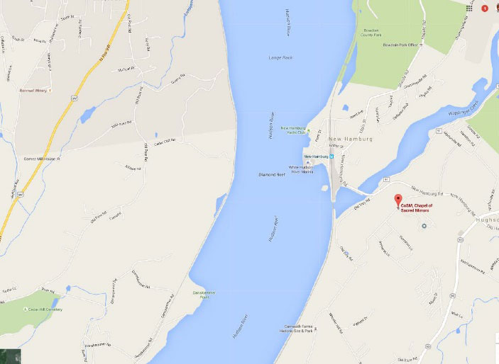
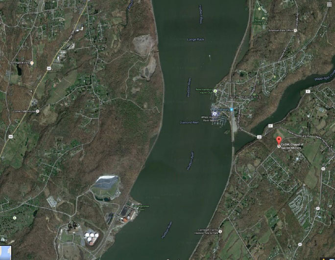
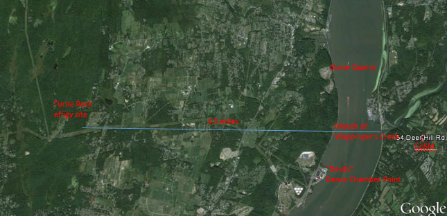
Danskammer Point at bottom, middle and mouth of Wappinger Creek at right middle of map and satellite image.
When Hudson sailed past that point of land on the river, over 400 years ago, it must have already been a sacred, ceremonial place for the native population dating back many generations, if not hundreds or thousands of years. But why that point of land on the river?
The native population in that area, at that time of first contact with Europeans, are known as the Wappinger, an Algonquin speaking tribe from the east side of the Hudson River. Perhaps it was the Wappinger or their close Lena Lenape nation cousins from the western shore of the Hudson, the Munsee or Delaware, who were carrying on a tradition at that special spot on the river that evening. (3) These tribes and many others from the northeast had established sacred, ceremonial locations scattered across the landscape. These sites and their locations were not chosen at random, but were identified, created or recognized as having elements that represented a specific and sophisticated belief system.
This system would have held a 3 dimensional world view, whose different components, or levels, would include the sky above, the plane of the living and the underworld below. (4)
So, what were the elements that would have made the Danskammer Point location a sacred ceremonial site to the ancient, native population?
A quick look at the map and satellite image of the area of Danskammer Point and the mouth of the Wappinger’s Creek reveals an interesting relationship. From Danskammer Point, of course, there is a year round clear view across the unobstructed river to the mouth of the creek, about a mile to the northeast.
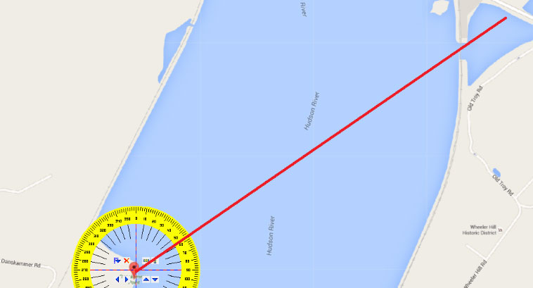
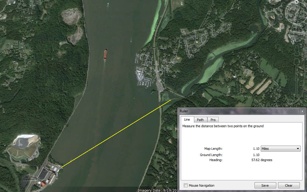
The azimuth or angle of the direction of sight to the horizon, from the furthest point east on Danskammer Point to the mouth of Wappinger’s Creek is 57 degrees from true north. This closely matches the expected angle to the horizon, or azimuth, of the summer solstice sunrise on June 20th or 21st each year. As the term “solstice” means Sun stand still, the sun remains at this location on the horizon for a few days, marking the beginning of summer, before beginning its slow, daily trek back south, toward its winter solstice resting position. Below is an image from Google Earth of the location on June 21st, 2016 at 5:23 AM, both simulating and documenting the alignment between Danskammer Point, the mouth of Wappinger’s Creek and the position of the sun on the horizon on summer solstice sunrise.
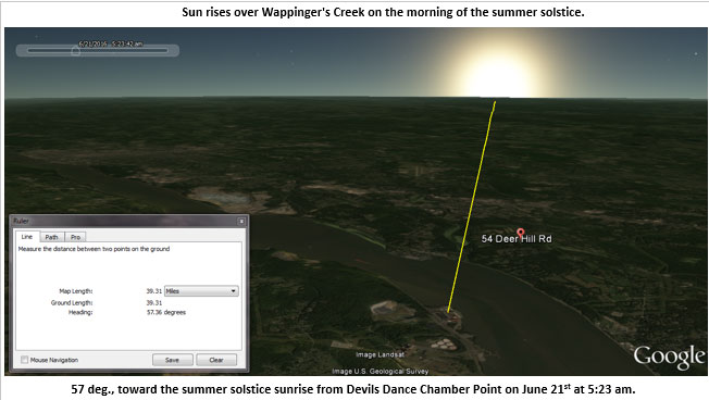
Though it may come as a surprise to find these two locations yield such an alignment on the longest day of the year, I think this would have been well known to the ancient native indigenous population of the region. It’s is believed that this area of the Mid-Hudson Valley region has had continuous human habitation for at least ten thousand years or more, using rich and sustainable available river and land resources. (5) And though these geographic features were obviously not created by the ancient population, they were no doubt recognized early on as a place where this celestial event occurred and could be easily viewed year after year and generation upon generation. For this reason, there can be little doubt this site on the river was very important to the Native Americans inhabiting the area and wider region.
We’ll never know what the natives were celebrating on the late summer September evening so long ago, but I suspect if Hudson and his crew would have sailed past that point of land on a late June day, at the first days of summer, they would have seen an even larger gathering to celebrate and welcome the summer sun.
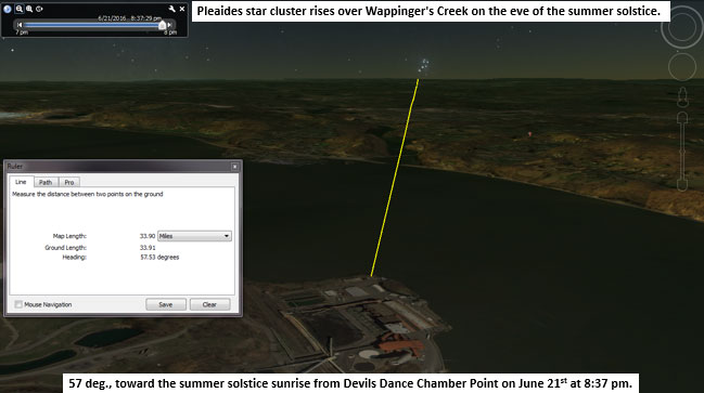
What’s just as interesting, if no less surprising, is the additional fact also confirmed and documented with Google Earth, that on the evening of the summer solstice, looking toward where the sun rose that morning over the mouth of the Wappinger’s Creek, we see the rise of Pleaides at the same azimuth on the horizon after sunset, of 57 degrees from true north.
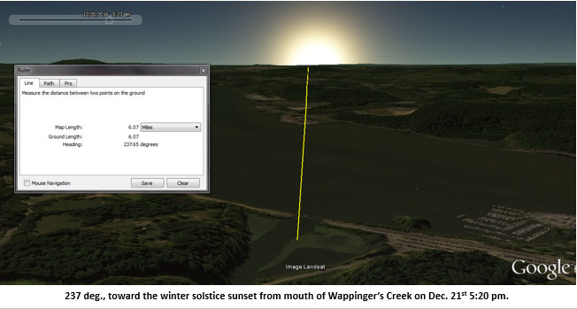
Now let’s reverse the alignment and see what we find if we look from the mouth of Wappinger’s Creek southwest over Danskammer Point. Using a chart provided by Professor Curtis Hoffman of UMASS Bridgewater, we see that the reciprocal of the 57 degree azimuth of the summer solstice sunrise is the winter solstice sunset at 237 degrees from true north, on Dec. 21st, the shortest day of the year.
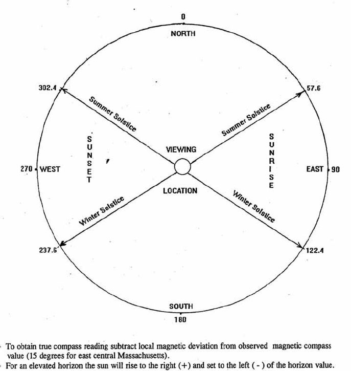
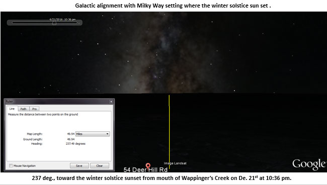
So, on the darkest day of the year, Dec. 21st, when viewed from the mouth of the Wappinger’s Creek, one would see the sun set directly over Danskammer Point across the river at 237 degrees azimuth.
And if after sunset we continue to view the night sky on that cold winter evening, we would witness one more final observable astronomical event in the sky as the Milky Way appears to set and align with the horizon just after 10:30 PM, just where the winter solstice sun set at nightfall.
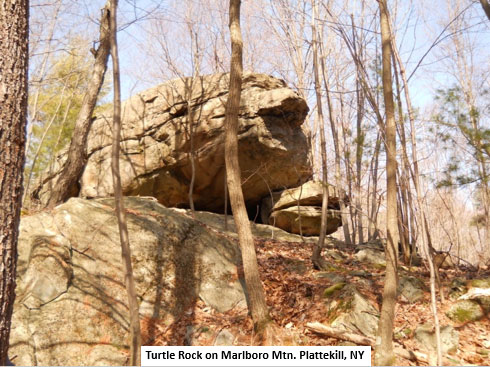
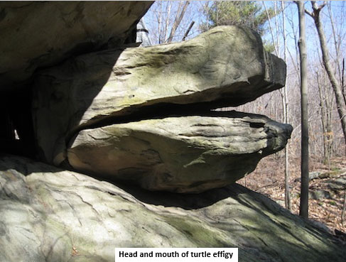
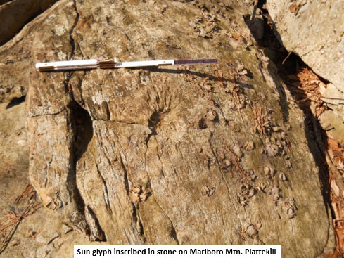
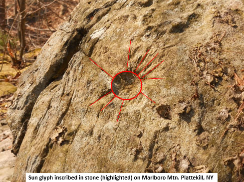
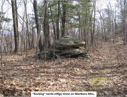
Going through my database of site locations in the Catskill Mountains, Shawangunk Mountains and Hudson Valley, I located the site that’s been documented closest to Danskammer Point and the mouth of the Wappinger’s Creek, which turns out to be the Turtle Rock Ridge complex on Marlboro Mountain, in Plattekill, NY. The site is located approximately 4.5 miles due west of the mouth of the Wappinger’s Creek, which puts it on an equinox sunrise and sunset alignment with the mouth of the creek to the east. The Turtle Rock location is on a high ridge top with views to the west, over the Shawangunk Mountains, towards the Catskills in the distance. To the east the ridge drops down steeply towards the Hudson River and Newburgh Bay, which is visible from a distance through the trees. The Turtle Rock site complex consists of an extensive collection of cairns, stone walls, and includes turtle effigies, rock shelter, inscriptions, glyphs and solstice viewing portals, all in one site, and in relatively close proximity to Danskammer Points and the Wappinger’s Creek.
Below are pictures of Turtle Rock in Platekill, NY.

To me there can be no doubt why Danskammer Point (and the mouth of Wappinger’s Creek) and Turtle Rock Ridge were important centers of Native American ceremonial practices. I believe the evidence presented here speaks for itself.
Lastly, a large stone quarry visible in the maps and satellite images, sits directly on the Hudson River, across and just north from the mouth of the Wappinger’s Creek and also just to the north of Danskammer Point. Quarry Rd. leads to the site (possibly attesting to its age) and Geologist Philip Laporta of the Center of the Investigation of Native and Ancient Quarries (CINAQ) http://www.nativequarries.org/ is investigating the site to determine if it’s an old flint or chert mine, which could indicate use in ancient times. The mine appears to be no longer in use. (6)
Landscape Astronomy:
Landscape archaeology and archaeoastronomy are considered two important concepts which relate to the belief system of ancient humans across the globe. We can think of landscape astronomy, as another important concept that marries the two. Perhaps the oldest form of observational astronomy performed by ancient cultures was the preservation of observations in a manner that sought to exploit the natural environment, to highlight and create relationships with events on the horizon, such as sunrises and sunsets, moonrises and moonsets and star rises and star sets. Points of land on bodies of water, such as oceans, lakes, rivers and creeks, could be key to identifying alignments with landmarks that line up with other nearby or distant landscape features and important events on the horizon, in the sky across from the viewing point. Such landscape astronomical alignments could also be ancient “observatories” created using various straight line travel ways or paths that serve a similar purpose; pointing the way to an important event in the sky, or on the horizon.
Landscapes and Skyscapes:
According to Professor Gary Urton, Chair of Anthropology at Harvard University, a ‘landscape’ reflects a living synthesis between humans and the land they encounter and a ‘skyscape’ includes a portion of the sky or horizon, from which a cultural picture can be constructed. In his book At the Crossroads of Earth and Sky (1981), and up through his recent Keynote presentation at the NEARA 2016 Fall Meeting near Boston, MA, Professor Urton documents how among other things, Native American complex, 3 dimensional cosmologies, included observing, recognizing and preserving alignments associated with the Summer Solstice Sunrise in conjunction with the rise of Pleiades. Urton also shows these cultural cosmologies incorporate the galactic plane, or Milky Way, into their belief system, as a guiding force connecting the Living World with the Sky World. With the Danskammer Point/Wappingers Creek alignments are we witnessing evidence of a Pan American phenomenon involving the summer solstice sunrise in conjunction with the rise of Pleiades and the winter solstice sunset in conjunction with the Milkyway, as part of a complex, universal Native American cosmology and belief system?
Conclusion:
In the geography of the Danskammer Point area and its surroundings, including the mouth of the Wappinger’s Creek, the Turtle Rock Ridge complex and possibly the stone quarry on the river to the north, we see the coming together of several important elements of the Native American belief system and world view, linking the Earth and sky. By establishing evidence recognizing ancient populations carried out observational astronomy and preserved those observations by memorializing and associating site locations within a sacred landscape, we give credit where credit is due and not previously assigned in the Northeast of America. Many other site locations and associated relationships, no doubt, await discovery and documentation before the complete picture is more fully understood or discerned. With the identification of the Danskammer Point/Wappinger Creek alignments, associated with the rise of the summer solstice sun and Pleaides and the setting of the sun on the winter solstice sunset and the galactic alignment, we see evidence that points to an understanding of the heavens and their movements, by ancient natives, which includes the Precession of the Equinox. For due to precession, over time, the alignment of Pleaides with the summer solstice sunrise and the Milky Way with the winter solstice sunset, would trade places creating a kind of precessional clock to be tracked with the ages, by those who knew to look and keep track.
Further research:
The so-called Poughkeepsie Standing Stone, is on the corner of Oakwood and Delavergne in Wappinger’s, NY. According to Sal Trento’s book The Search for Lost America, the stone is tilted in the direction of 202°, and Trento’s team followed that course for just under two miles, which led them to the mouth of the Wappinger’s creek, and the view of the Danskammer Point, so he believed they were all tied together. He also mentions finding inscriptions along the path from the standing stone to the creek. The stone was said to be inscribed in Iberic Ogam. This led Trento to speculate about overseas visitors to the area the Wappinger Indians inhabited. And, according to Trento, for reasons known only to the Wappinger tribes, the land surrounding the creek was the capital of their confederacy. Trento’s research showed that not only was the region the political capital of the confederacy, but it was the religious and spiritual capital as well. (8)
So, the ancient astronomy now associated with Danskammer Point and the mouth of the Wappinger’s Creek not only fits the model established by the work of Harvard Professor Urton, but may also answer Trentos’ question as to why this was a spiritual and political center of the Wappinger’s world, perhaps even acting as an “Axis Mundi” or a central pillar their world revolved around, connecting Heaven and Earth for all of time.
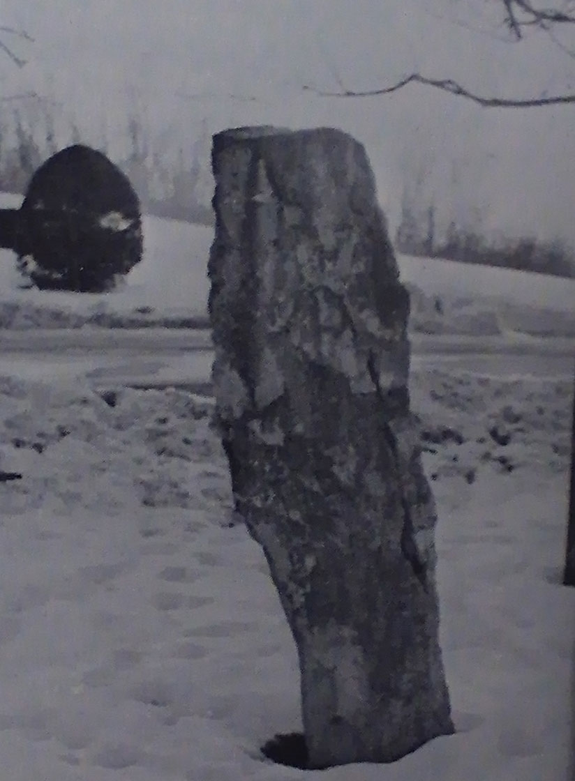
Photo credit: Salvatore Trento
Credits:
All map and sun position images are courtesy of Google Earth.
All photographs are by the author unless otherwise noted.
References:
- http://www.highlandspreservation.org/uploads/2/5/1/7/2517862/stone_chambers_of_kent.pdf
- The Tavern Lamps are Burning: Literary Journeys Through Six Regions and Four Centuries of New York State. Carl Carmer Fordham Univ Press, 1996
- History of the Indian Tribes of Hudson’s River: Their Origin, Manners and Customs, Tribal and Sub-tribal Organizations, Wars, Treaties, Etc. Edward Manning Ruttenber J. Munsell, 1872
- https://faculty.gcsu.edu/custom-website/mary-magoulick/worldview.htm
- Paleoindian Occupations in the Hudson Valley, New York Jonathan C. Lothrop New York State Museum, January, 2012. Form the book Late Pleistocene Archaeology and Ecology in the Far Northeast, Edition: 2012, Chapter: Paleoindian Occupations in the Hudson Valley, New York, Publisher: Texas A&M University Press, Editors: Claude Chapdelaine, pp.9-47
- Center of the Investigation of Native and Ancient Quarries (CINAQ) http://www.nativequarries.org/
- Landscapes and Skyscapes in Native South American Cosmologies. Gary Urton, Chair of the Dept. of Anthropology, Harvard University, MA. Presentation to NEARA, Billerica, MA, Oct, 22nd, 2016.
- The Search for Lost America. The Mysteries of the Stone Ruins. Salvatore Michael Trento, Contemporary Books, Inc. Chicargo, IL 1978,
I used to live across the street from the Poughkeepsie Standing Stone and didn’t give it much thought until one day, my dad (who is an engineer), walked up to me with a sheet of calculations. He had been staring at this rock every day for 15 years and felt compelled to plot it’s potential dimensions. According to him, the rock would need to be buried about 17 feet in order to “sit” the way it does. It suddenly became a lot more interesting. There are some interesting spots in Bowdoin Park that seem to point to land modification and long-time habitation. Thank you for this interesting article.
We seem to have gone in a circle. The Natives used observation to link the stars and the land. We can use Google for the same thing. Great work.