This is part 2 of researcher and writer Brien Foerster’s regular column here at Grahamhancock.com. Brien’s study and insight into the Inca’s ancient origins shed a new light on that famous South American culture. The implications are both startling and far reaching suggesting a connection to a pan Pacific civilization reaching back to mankind’s most distant past. Join Brien on the GrahamHancock.com Mysteries Message Board where he will be conducting a continuing discussion surrounding his research and regular contributions to these pages. Please check in for the next installment from Brien.
In part 1 I wrote about the Inca and how they were regarded as the descendants of the Viracochas, a people of mythic proportions seemingly lost in time and often thought of as being fictitious. Part of the reasoning behind this is the fact that much if not most of Inca history, which was mainly oral in nature, was crushed once the Spanish conquered Cuzco; the administrative, military and spiritual center of the Inca in 1533. What they did have as a “written” tradition was the khipu system, used extensively by them, and dating back as far as 5000 years ago, as samples have been found at the desert site of Caral, 200 km north of Lima.

Samples of Khipus: Photo by Bing Free Images
The khipu system, a woven series of cords of different colours that were tightly twisted together and had strategically positioned knots in them, is believed to have mainly been an arithmetical system much like the abacus, according to experts such as Gary Urton of Harvard University. Dr. Urton speculates that not only may the khipus have base 10 as their arithmetical system, but that they may also be of binary code, the same as a computer language. Other researchers speculate that the khipus are a form of coded language.
However, the Spanish destroyed all the khipus that they came across, as a way of destroying any recorded system of the Inca, and to this day the quechua ( also known as runa simi ) language spoken by the Inca is frowned upon by the Peruvian government and clergy. Also, as result of the half-Inca Atahuallpa massacring the vast majority of the Inca royal family just prior to the arrival of the Spanish in 1532, and the foreign diseases that had arrived even earlier, including smallpox, we are left with little or nothing of the history of the Inca from their perspective, because few survived, and those that did had no records to refer to, except memory.
I spoke of the glimpses we have from some of the earliest Spanish chroniclers and what was left of the Inca descendants that the Inca family, which controlled all affairs of the Tahuantinsuyu ( four corners of the Inca world, ) that the Inca were a distinct race of small population. These writings speak of them as having red or even blonde hair, very light complexion, and being very tall with possibly larger than normal crania

Inca skulls in the Coricancha Museum in Cuzco, Photo by Brien Foerster
Viracocha, the creator God, must not be confused with Viracochan, who were the people descended from, and the ancestors of the Inca, whose home and center was the enigmatic city, or city state of Tiwanaku ( Tiahuanaco ) in present day Bolivia.
A large sculpted stone face profile, and by large I mean more than 300 feet tall, looms above the Sacred Valley near Cuzco and looks down upon the site of Ollantaytambo, a place attributed to the Inca which is as large and complex in nature as Machu Picchu.
Oral tradition states that it is the portrait of Viracochan, a Christ like figure who arrived and taught the seemingly “savage” people of the area agriculture, metallurgy, astronomy, and the other “civilized” arts and sciences. He is described as being tall, and perhaps had light coloured hair and a beard; opinions and stories differ, as does the timeframe in which he showed up, but it was most likely before the time that the Inca entered the Sacred Valley and Cuzco which occurred in the 12th century. As the Sapa (high) Inca was Manco capac, it seems clear that Viracochan was an earlier visitor/teacher.
Most tour guides in the area will say that the local villagers carved this monumental face, complete with beard, to honour the teacher Viracochan, but that is like saying that slaves with mud ramps and wooden rollers made the pyramids in Giza, Egypt; completely presposterous.

Carved stone head of Viracochan; Ollantaytambo Peru. Photo by Brien Foerster
Another ancient group of people who lived in what is now called Peru and possibly had reddish blonde hair and fair skin were the Chachapoyas. Their main center of habitation was at a site called Kuelap, approximately 750 km north of Lima. The conquest of the Chachapoyas by the Incas took place, according to the Inca descendant and chronicler Garcilaso de la Vega, during the government of Tupac Inca Yupanqui in the second half of the 15th century.
The Chachapoyas were not receptive to Inca expansion and annexation, and fought long and hard battles but eventually surrendered. When civil war broke out within the Inca “empire,” the Chachapoyas were located on middle ground between the northern capital at Quito, ruled by the half blooded Inca Atahuallpa, and the southern capital at Cuzco, ruled by Atahuallpa’s brother Huascar, who was Inca of full blood. Many of the Chachapoyas were conscripted into Huascar’s army, and heavy casualties ensued. After Atahuallpa’s eventual victory, many more of the Chachapoyas were executed or deported due to their former allegiance with Huascar.
Once the Spanish had murdered Atahuallpa in 1533, and had taken over what is now present day Peru, the last of the Chachapoyas succumbed to disease and starvation, thus their bloodlines if present at all today, would rarely display the much debated reddish blonde hair and light skin characteristics.
They had no written language, and since none survive to this day, the Incas and the Spanish conquistadors are the principal sources of information on the Chachapoyas. Indeed, so little is known, that the name that they called themselves is lost. The name Chachapoyas was one given, or more likely imposed upon them by the Inca, and loosely translates as the “warriors of the clouds.” The meaning of the word Chachapoyas may have been derived from sacha-p-collas, the equivalent of “colla people who live in the woods” (sacha = wild p = of the colla = nation in which Aymara is spoken). Some believe the word is a variant of the Quechua construction sacha puya, or People of the Clouds.
Writings by the major chroniclers of the time, such as the Inca Garcilaso de la Vega were based on fragmentary second-hand accounts. Much of what we do know about the Chachapoyas culture is based on archaeological evidence from ruins, pottery, tombs and other artifacts.
The chronicler Pedro Ciezo de Leon offers some picturesque notes about the Chachapoyas:
“They are the whitest and most handsome of all the people that I have seen in Indies and their wives were so beautiful that because of their gentleness, many of them deserved to be the Incas’ wives and to also be taken to the Sun Temple.”
The main complexes of the Chachapoyas are believed to have been constructed about 800 to 900 A.D. It is thus possible that they are an off-shoot of the Viracochan culture of Tiwanaku, as this is also the time period when environmental pressure caused the priest kings of that civilization to abandon Tiwanaku and become the Inca. Of course, this is complete speculation, but the timelines do fit.
Or were they Europeans? This area of thought I wish to completely steer away from, as many will brand me a racist. The truth is, no one knows, except the Chachapoyas themselves, and they are silent, since they are extinct.

Sarcophagi of the Chachapoyas at Kuelap, Photo from Bing Free Images
The Viracochans according to the oral traditions, after having taught the people the ways of civilization left by sea in the direction of the setting sun, as in west. It is not written as from where they left, but one such candidate spot is very intriguing.
Due west of Tiwanaku, on the Peruvian coast is a seaport called Matarani. This area has had human occupation since before the demise of Tiwanaku. The name itself stands out because it is neither a quechua nor an aymara name, it is Polynesian. Mata means “eyes” and rani is “heaven.” What I find curious is that such a name could imply that the eyes are either looking down from heaven, or looking up. If looking down we could easily stray off into a discussion of sky ancestors or UFO, which I won’t do here, though it is tempting.
If looking up, this could refer to astronomy and celestial navigation, and amongst the finest star navigators in the world were and are the Polynesians. The closest land mass west of Peru is Rapanui, also called Easter Island, and is populated by Polynesian people. The first European to land at Rapanui, which he named Easter island was Jacob Roggeveen. On his expedition of 1722 he gives us our first description of the islanders. They were “of all shades of color, yellow, white and brown” and they distended their ear lobes so greatly with large disks that when they took them out they could “hitch the rim of the lobe over the top of the ear”.
In the oral traditions of the people of Rapanui, the first colonizer was a seafaring chief called Hotu Matua. The translation of this is Hotu=star and Matua=father, so sky father. Again, like the discussion above, does it maybe mean “father from the sky” or “father who looks at or watches the sky.” If it is the latter, then could could simply mean that Hotu Matua was a celestial navigator, if the former, well no, we are not going to go there in this paper.
It is said that Hau-Maka had a dream in which his spirit travelled to a far country, to help look for new land for King Hotu Matua. In the dream, his spirit travelled to the Mata ki te rangi (Eyes that look to the Sky).
The seaport of Matarangi and the original name of Rapanui are almost identical, which may be a coincidence but maybe not. It is very common for people to name a new land after their homeland ( remember Plymouth rock in the USA; where did they come from?)
Hotu Matua was a “Long Ear” as were the other nobility that made up Rapanui. The other class of citizen were called the “Short Ears.” Interestingly, the process of lengthening of the ear lobes by inserting metal objects in them was also a practice of the Inca.
There is much debate as to when the first migrants reached Rapanui; the carbon 14 based studies of Thor Heyerdahl suggest a date of around 400 A.D., but other researchers claim the date to be closer to 800 A.D. This time frame fits in with the culture at Tiwanaku either being still vibrant, or in decline. Thus the theory that Hotu Matua (probably having an ealier quechua or aymara name that was changed through time) was the founding father so to speak could have been the result of exploration and expansion, or survivors from Tiwanaku seeking a new home.
Some plants on Easter Island clearly come from South America, such as the islanders’ staple food the sweet potato (which is known by its Quechua name kumara), and also manioc and gourd. Similarly, two species of freshwater plants, found in Easter Island’s crater lakes but nowhere else in the Pacific, and both useful to man, come from South America. One of them was the totora reed, which dominated the banks of South America’s Lake Titicaca and was cultivated in vast irrigated fields in the desert valleys on the coast below; it was used for making mats, houses, and boats. The other was known to the islanders as tavari, and was used as a medicinal plant. Like the totora, it grew in Lake Titicaca. This last information supports the case for contact with Tiwanaku.
The arrival of the “short ears” is hotly debated; they either arrived before or after the “long ears” obviously, but this has not been proven. What is clear is that the “short ears” were a lower class than the “long ears” and were the working class. It is believed that a rebellion of the “short ears” was what caused the civil war that all but destroyed the entire population.
The “short ears” amongst other duties, was to carve the Moai, the giant heads that dot the landscape of the island and are of course world famous. They are clearly meant as depictions of the “long ears” due to the, well, long ears that they have. However, other interesting characteristics of the faces are the thin lips, which are not a Polynesian feature, the inset shell eyes which is not common in Polynesia, the long thin noses which Polynesians don’t have, and the red top knot.
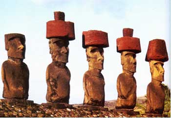
Moai and altar on Rapanui. Notice the red top-knots. Photo from Bing Free Images
The Inca are believed to have had very long noses which extend directly to the forehead as do the Moai, and the red top knot hints that their hair was also red. Some may say that the red was used because it is the common colour of Polynesian royalty, but I tend to differ.
Then of course we have two other interesting characteristic to the story. The only hieroglyphic or writing system found in all of Polynesia is the Rongorongo of Rapanui. If the major wave of migration had come from Polynesia, why would we not find Rongorongo or something similar in the Society Islands (Tahiti, Marquesas and Tuamotus) which is the reputed Polynesian homeland, and the closest inhabited islands to Rapanui?
Some will immediately jump on the fact that the Inca and Tiwanakans also had no written or hieroglyphic language, but this is not necessarily the case. The early Spanish chronicler Fernando de Montesinos, author of Memorias Antiguas y Historiales del Peru (1642) (Ancient Memories and Histories of Peru) wrote that the early Inca did indeed have at least a hieroglyphic system which was banned by Sapa Inca Pachacutec (also known as Pachacuti Inca Yupanqui) out of the fear that the general public might learn it. The Inca were supposedly generous and kind rulers, supposedly, in many ways, but the public were restricted as to what they could do and learn.
It was clearly documented by early missionaries that even the most intelligent and well informed islanders could provide the meaning for any of the signs or provide ideograms for the simplest of words. The following quotes come from Heyerdahl’s excellent treaty on ‘Early Man and The Ocean‘
‘They knew each tablet to represent a specific text, but disagreed about which text belonged to which tablet. If one tablet was substituted for another in the middle of their recital, the continued the original text uninterruptedly. The text was recited with singing rather than speaking voice. They piously copied the original old tablets on new boards, and regarded them as magic objects of the greatest value’
Although there were several claims that the script had been deciphered, none have proven worthy of scrutiny. Script itself is a non-Polynesian characteristic and the search for its origin was eventually rewarded through one of its particular characteristics, which is that it is ‘arranged in boustrophedon, i.e. in a continuous serpentine band where every second line is turned upside-down. Europeans, Chinese and the Indus Valley people never wrote in boustrophedon, and the language had been forgotten by the time of the Europeans first arrival. In fact, the only place in the world where this particular style of writing can be found is in South America; Peru to be precise.
The Easter islanders themselves are specific in their tradition of the first immigrant king, Hotu Matua, having brought with him sixty-seven written tablets when he came from his home in the far-east. Heyerdahl mentions that on the arrival of the Europeans, the Indians of Lake Titicaca area still ‘continued a primitive form of picture writing‘. This conforms with the observation by Russian rongo-rongo expert J. V. Knorozov, that the only two places where ‘reversed boustrophedon’ occur in the world are Easter Island and ancient Peru.
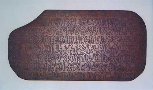
Replica of a wooden Rongorongo Tablet from Rapanui, Photo from Bing Free Images
Sariemento Gamboa, upon consulting as assembly of forty-two learned Inca historians recorded the following in reference to the ninth Inca ‘Patchacuti Inca Yupanqui‘:
‘…after he had well ascertained the most notable of their ancient histories he had it all painted after its order on large boards, and he placed them in the house of the sun, where the said boards, which were garnished with gold, would be like our libraries, and he appointed learned men who could understand and explain them…’
It was later on that these boards were destroyed for reasons stated above.
The other interesting thing is the birdman cult that developed on Rapanui. Are birdman depictions or legends prevalent in the rest of Polynesia? Not to my knowledge. But how about in Tiwanaku? Of course. One look at the Gate Of The Sun at Tiwanaku shows more birdman transformation characters on it than any other. This style of depiction is also found in other Peruvian cultures.
And then we have the Ahu, or altars which are found on Rapanui. Even a quick glance at them by someone who has been to either Tiwanaku or Cuzco and the Sacred Valley of Peru will note the startling similarity in design and execution.
The finest platform masonry, such as that found at Ahu Tahiri (one of the two ahu at Vinapu), consists of ‘enormous squared and tooled stones, that turn the edge of the toughest modern steel’. The best facade slabs commonly weigh 2 or 3 tons. At Vinapu one of the polished basalt slabs measures 2.5 by 1.7 m (8 by 5.5 ft) and weighs 6 or 7 tons, while one at Ahu Vai Mata is 3 by 2 m (10 by 6 ft), and weighs 9 or 10 tons.
John Macmillan Brown writes:
The colossal blocks are tooled and cut so as to fit each other. In the Ahu Vinapu and in the fragment of the ahu near Hangaroa beach the stones are as colossal as in the old Temple of the Sun in Cuzco, they are as carefully tooled, and the irregularities of their sides that have to come together are so cut that the two faces exactly fit into each other. These blocks are too huge to have been shifted frequently to let the mason find out whether they fitted or not. They must have been cut and tooled to exact measurement or plan. There is no evidence of chipping after they have been laid. Every angle and projection must have been measured with scientific precision before the stones were nearing their finish.
A recent expedition by Dr. Robert Shock, a geologist, to Rapanui revealed interesting results. According to him, based on his knowledge of the wear patterns of stones due to rain and wind driven sand, for example, the Moai made of basalt are the oldest, as are the altar platforms. He was unable to find large basalt deposits near to where the Moai presently stand, but speculate that the basalt source is presently under the ocean.

Stone altar on Rapanui. Eerily like Inca stone construction Photo from Bing Free Images
There is an oral history in New Zealand of an ancient race of peoples that sailed there from the east and populated the country many years before the Maori – these people were called the Waitaha. They are not recognised as a race in NZ officially because to do that would succeed tribal rights over areas of land in treaty compensation negotiations away from Maori tribes but basically it is said that the Waitaha people sailed to NZ, populated it and lived in peace there for many years.
The difference between this race and the Maori at the time is that the Waitaha were totally peaceful and that they were white. They were fair skinned people some with blue eyes some with green, they had blond hair a lot of them and some had red, they were tall and lithe and were mainly vegetarians. They had no martial arts or war structure as they were totally into peace so that when the Maori came they were easily over run and eaten or taken as slaves because they refused to fight – the memory of them is kept alive through their decendants who were taken as slaves and assimilated into Maori society. That is why many Maori have red hair and some have green eyes. They were expert gardeners and the garden beds they made can still be seen in some areas.
In 1995 a book by Barry Brailsford, Song of Waitaha: The Histories of a Nation, claimed that the ancestors of the “Nation of Waitaha” were the first inhabitants of New Zealand, a pale-skinned people who had sailed there from Easter Island more than 2000 years before Polynesians arrived. It was claimed the “secret” Waitaha story had been suppressed for 200 years and the evidence of their occupation and existence, such as stone structures, had been mistaken for natural formations or Maori artifacts.
Although a series of further books, web sites and New Age events have been based around these claims, they have been widely dismissed as inaccurate by conventional scholars. Historian Michael King noted: “There was not a skerrick of evidence – linguistic, artifactual, genetic; no datable carbon or pollen remains, nothing – that the story had any basis in fact. Which would make Waitaha the first people on earth to live in a country for several millennia and leave no trace of their occupation.”
No trace of their occupation? How about the Kaimanawa wall? Near the southern end of Lake Taupo, New Zealand there is enigmatic wall called Kaimanawa Wall. The wall is composed of megalithic blocks with symmetrical corners. The level top suggests it may have been a platform pyramid, similar to those found on several islands in the South Pacific. Until the jungle is cleared and a full excavation takes place, the Kaimanawa Wall remains a mystery.
Barry Brailsford has been the chief investigator of the Kaimanawa wall, aided by American D.H. Childress, and others. Childress, who investigated the site in 1996 when it came to the attention of the outside world, wrote (in A Hitchhiker’s Guide to Armageddon) that:
“…the blocks seem to be a standard one point-eight meters long by one point-five meters high. The bottom block runs straight down to one point-seven meters and beyond. The stone is local ignimbrite, a soft volcanic stone made of compressed sand and ash. The nearest outcrop of such stone is five kilometers away. The blocks run for twenty five meters in a straight line from east to west, and the wall faces due north. The wall consists of approximately ten regular blocks that are seemingly cut and fitted together without mortar.”
Supporting the contention that a pre-Maori people lived in New Zealand are the bones of the kiore, a type of rat alien to New Zealand, which was likely introduced by the first settlers. Some kiore bones have been dated as 2,000 years old — centuries before the first Maoris arrived.
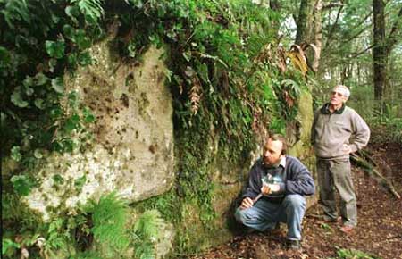
Kaimanawa stone wall near Lake Taipo in Aotearoa, Photo from Bing Free Images
A cursory look at a map of the currents of the southern Pacific Ocean shows that strong currents move from the Peruvian coast to Rapanui, and continue on in a curve to New Zealand. They then continue on, hook up with the Humboldt Current and return to Peru.
Thor Heyerdahl in his 1947 Kon Tiki raft expedition left the port of Callao near Lima and 101 days later reached the Tuamotu Islands. The balsa craft was clearly not as hydrodynamic as a canoe or other ship would be, and the sail configuration, being square and not very “tuneable,” much more like a Viking ship, would not be very efficient.
It is quite possible that Heyerdahl chose this shape because it was in line with the proposed design of his Viking ancestors’ sails, and that there is no record of ship and sail designs in Peru from the distant past, or are there?

Early Spanish depiction of balsa craft off Ecuador, Photo from Bing Free Images
In fact, drawings made by early Spanish seafarers show that the balsa crafts that Pizarro and his crew saw ( and boarded ) had sails which are very similar to those of Polynesian sailing canoes; the so-called crab-claw design; still inn use on the Hawaiian voyaging double hull canoe Hokule’a, and more historically accurate on the Hui O Wa’a Kaulua of Maui’s Mo’olele canoe. Had Heyerdahl chosen instead to depart from Matarani, he may well have wound up landing at Rapanui.
The ability to reasonably easily sail from Aotearoa to Hawaii is a given; as the Maori originally came from Tahiti, according to the archaeological data as well as their own oral traditions. The ancestral homeland of the Maori, at least those of the main wave in the 12th century is called Hawaiiki, and is at the present day named Tahiti.
More specifically, Hawaiiki is the island of Raiatea, which for hundreds of years if not millennia has been the center of Polynesian seafaring. The marae (temple) of Taputapuatea (most sacred white place) was the wayfinding or traditional navigating university of the Polynesian people; for one reason, it is strategically located in the center of the so-called Polynesian triangle.
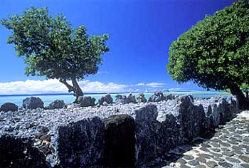
Marae of Taputapuatea on the island of Raiatea, Tahiti, Photo from Bing Free Images
This triangle is composed of 3 points, designated by the lands of Hawaii to the north, Rapanui to the southwest, and Aotearoa to the southwest; all three are clearly people of the same genetic source, as evidenced in their oral traditions.
Also, their language is almost identical, aside from minor differences in pronounciation. The name which they call themselves, Maoli in Hawaii, and Maori in Tahiti, Aotearoa and Rapanui, simply means “people.” The k and l sounds of Hawaiian words, such as Moku ‘ula ( Red Island, a sacred place on Maui ) in the other three places would be Motu ‘ura.
The major wave of migration to Hawaii occurred about the 12th century from Raiatea, under the leadership of the priest Pahao. They, however, did not find the islands inhabited. There was a peaceful race of people named the Mu who had been there since time memorial, and Pahao, who had visited the islands previously on a spying mission, now came with a large force of warriors in order to subdue the Mu.
The origin of the Mu people is somewhat lost in the mists of time, though most archaeologists claim that they came from the Marquesas Islands somewhere between 0 and 300 A.D. This is solely based on the idea that artefacts discovered, especially on the island of Kauai resemble those found in the Marquesas.
Some of the Hawaiians themselves say that their people have always been there, the Mu that is. The Tahitians began conquering the islands and did so in a northerly direction; and the seemingly gentle Mu retreated as the advance continued. The last major island on which they existed was Kauai, and it is here that most of the stories about them have been written.
The Tahitians called them Menehune, or the little people, because the Mu were a gently, agrarian, and peaceful people. This term is still in use in the modern day, comically referring to mythical leprechaun-like people who are shy and hide in the forests. The real name is probably the Mana huna, or people of mana=spiritual power and huna=secret wisdom. They were, therefore, a people with psychic and other mind abilities that were not appreciated by the Tahitians.
Through genocide and assimilation the Mu ceased to exist several centuries ago, but an interesting characteristic occasionally shows up even today. Some descendants from the island of Ni’ihau, which is close to Kauai and became privately owned by the Francis Sinclair and Elizabeth Hutchinson in 1864, having purchased it from King Kamehameha V. As part of the agreement in the purchase, Hawaiian language and cultural traditions were to be protected, and in some ways enforced. Even to this day, radios, televisions and telephones are banned from the island.
The isolation of these islanders, who are almost all full blooded Hawaiians, has resulted in there being a very small gene pool. Some of them, who have moved to Maui for example, and whom the author has met, have red hair. This could very well being the result of inheriting genes from the first race of Hawaiians, the Mu, who in turn may be the descendants of the same ancient race of people that first populated Rapanui, and Aotearoa. The possibility is that they are the children of the priest kings of Tiwanaku.


