


Introduction
How Earth got its satellite, the Moon, is a controversial and unsolved problem. The idea that the Moon’s origin was a result of an impact of a Mars-sized planetesimal into the proto-Earth has been taught for decades. However, this theory is repeatedly challenged by some scientists. 1 The present paper presents new arguments favoring a capture of the Moon that rejects all models assuming a formation in the course of an impact. Moreover, the evidence found indicates a capturing at relatively recent times, i.e. at a time when humans already populated Earth. Regarding the timing and the capture of the Moon in general, besides prehistoric reports, geological peculiarities of Earth and Moon become proofing cornerstones of the model proposed. The capture of the Moon caused the Deluge, which thus turns out to have been a cosmic catastrophe which brought higher life on Earth close to extinction.
Unexplained geological structures
First of all, we don’t look at the Moon but at Earth. Large scale geology of Earth is currently interpreted within the framework of Wegener’s plate tectonics. Some substructures and a number of peculiarities, which plate tectonics cannot explain, have been overlooked or faded out. Among the unexplained facts, we come across with submarine canyons, which extend at the mouths of rivers as huge underwater channels or which are cut into tectonic plates at the shelf brims of continents, see Figures A and B. Given the widths and depths of their dimensions, we can exclude that today’s currents have washed or milled them. There are even deep-sea trenches that exist without relation to any structure at land or at the shelf. Within the category of submarine structures fall the following: the Aleutian Trench and the South Sandwich Trench. Both are long, curve-shaped deep-sea trenches situated at the shelf edge of a strait.
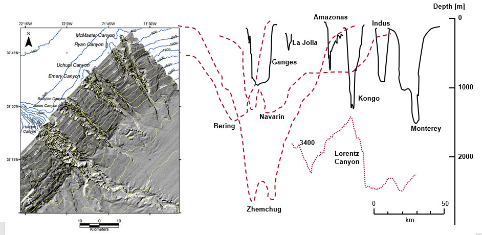
Figure A | Various submarine canyons (depths and profiles)
Left: Canyons in the continental shelf on the eastern shore of the USA (near and at the mouth of the Hudson River) 2
Right: Profiles and depths of some canyons. Solid lines indicate for river mouths, dotted lines for submarine canyons and the deep-sea trenches 3
(PD0)
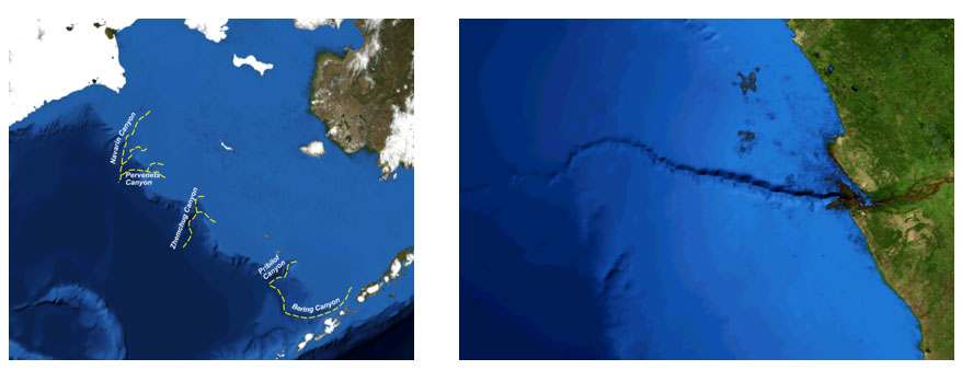
Figure B | Examples of submarine canyons
Pictured left: Trenches at a shelf edge (right Alaska, left Siberia) 4
Pictured right: An underwater canyon extending from the mouth of the Congo 5
(‘Beringian Margin canyons‘ and ‘Congo canyon‘ by Mikenorton (CCBYSA3.0))
In addition to the trench structures discussed above, exists a spaciously large weakening of the Earth’s magnetic field known as the South Atlantic Anomaly, see Figure C. At present this anomaly is often discussed in the context of a possible pole change of the Earth’s magnetic field. Different to this assumption, we believe and will argue in favor of an explanation which traces back Earths fissured surface and this magnetic anomaly to the same event. Both states can be consistently explained as a concomitant phenomenon of the capture of the Moon. In our model, the anomaly reflects the path the pre-Moon took during its close encounter with Earth. In the course of the overflight energy dissipation decelerated the Moon and led way to the capture of the Moon. Energy dissipation acted devastatingly on both bodies. Earth changed in geology, geography and fauna.
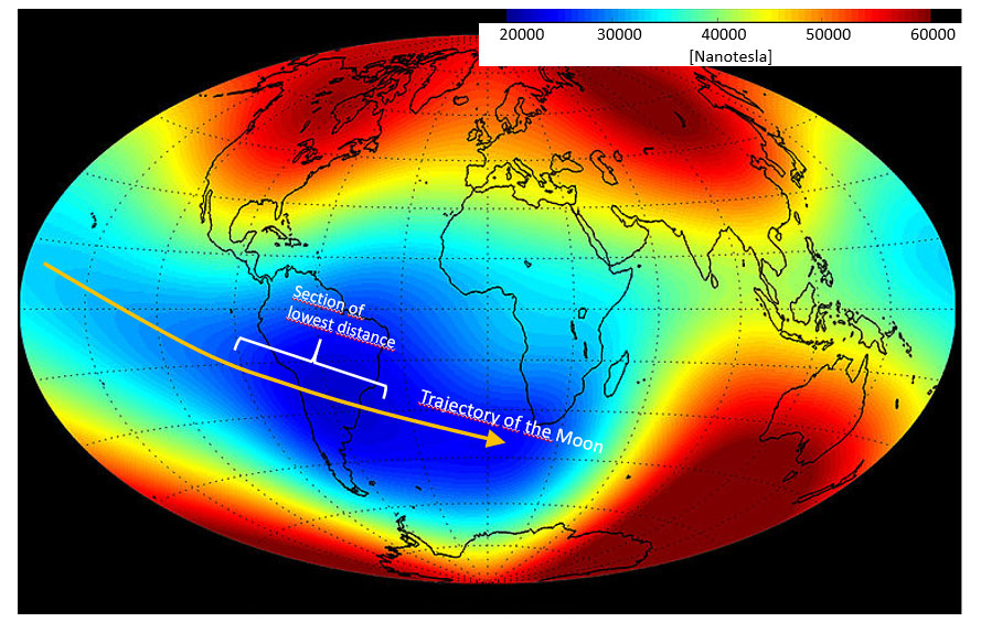
Figure C
Magnetic anomaly and assumed trajectory of the pre-Moon during its overflight across the globe 6
(PD0)
The primordial Moon
The pre-Moon – or alternatively the colliding planetesimal – must have come from somewhere. Let us narrow down the location of its formation, looking at its chemical composition. If we assign a primordial formation to the Moon in the asteroid belt beyond Mars, we expect a body with the Moon’s density (3,340 kg/m3). Showing a density of 3,930 kg/m3 Mars already comes suspiciously close to the Moon’s density. The specific density of a typical asteroid like Vesta amounts to 3,420 kg/m3. From this point of view, the specific density of the Earth’s Moon fits perfectly to a thesis that places its formation in the solar distance of the asteroid belt.
Coming to a quantitative analysis, we discuss the process of capture, which results from an extremely strong interaction of the two heavenly bodies.7 For this analysis, the orbit of the pre-Moon is assumed to have been elliptical with an aphelion at 2.6 AU and its perihelion at the orbital distance of the Earth. Given this orbit, the differential velocity on an encounter with Earth amounts to 6 km/s. Even without dissipative effects, a three-body interaction (Sun, Earth, pre-Moon) affects a transfer of angular momentum. Depending on relative positions, the encounter can noticeably accelerate as well as decelerate the lighter body. By computation, we find that the orbit of the pre-Moon changes as shown in Diagram 1 if the trajectories intersect behind Earth in a distance of 20,000 km. This modelled encounter reduces the orbital velocity of the pre-Moon by 0.67 km/s. However, without further energy dissipative processes, this deceleration does not lead to its capture.
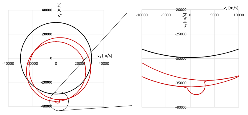
Diagram 1 | Computer simulation of a swing-by of the pre-Moon considering a dissipation-less encounter with Earth
Black: Speed profile of Earth
Red: Speed profile of pre-Moon across its orbit
Left: Velocity curve of a body with aphelion in the asteroid belt, passing Earth in a distance of 20.000 km.
Right: Indicated by the magnifying glass circle, enlargement of the section of the close encounter shown at the left.
Analysis of contributions to the deceleration of the pre-Moon
To capture the Moon from its assumed orbit, a kinetic energy in the order of 1030 J must be withdrawn. Even at maximum swing-by effect, the remaining energy is easily sufficient to reshape the Moon and Earth geologically, stop the Moon’s rotation and shorten the day on Earth by 10 minutes.
First, the stopping of the rotation of the pre-Moon contributes to the braking. During the very close encounter, Earth’s gravitation deforms the Moon’s globe into an oval. The continued movement of this tidal mountain stops the Moon’s rotation and at the same time withdraws kinetic energy. Assuming a primordial rotation frequency of 10 hours, the deceleration amounts to:
with Θ the moment of inertia of the Moon and ω the angular frequency of its rotation.
After the Moon’s rotation stopped the tidal mountain points constantly towards Earth. As a result, later on, the Moon orbits Earth in bound rotation.
The elongation of the lunar body is accompanied by work against gravitational cohesion. This deformation represents a second drain for the kinetic energy. In the quantitative figure, if the pre-Moon approaches Earth to the distance of the Roche limit of 18,000 km, a tidal mountain of 1770 km will bulge. For calculating the work associated, the change in potential energy is determined by assuming the lunar mass to be separated into two spheres showing a distance equal to the Moon’s diameter.
We get:
where G is the gravitational constant and r is the radius of the Moon.
Related to this energy, the deceleration is 1.19 km/s.
The deformation of the Moon has been preserved in its geological structure. Towards the Earth, we find its flat maria and a thin crust. Both are to be attributed to the Moon’s deforming.
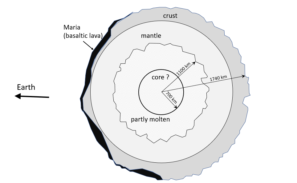
Figure D
Sketch of the inner structure of the moon 8
For illustration, the thickness and differences in the thickness of the crust are overdrawn.
Sketch according to: https://www.thunderbolts.info/wp/2015/12/20/the-antipodal-moon/
At a lunar distance of 20,000 km, the Moon’s gravity bulges Earth’s body by 4 km. The work associated to the static lift of an estimated mass (spherical cap of Earth’s body) of ~6.1017 kg will at best result in a deceleration of some m/s when assigned to the Moon’s velocity. The related energy of ?Pot = ??ℎ ≅ 1023? can be neglected compared to the energies mentioned so far. However, there is little static in the process and dominantly the dynamic effects cause the braking. Given an average speed of 10 km/s, the passing Moon pulls the gigantic tidal mountain behind it in a drag. The energy contained in this movement (E= ½ mv2) is gigantic and stands for a third energy drain. When this water avalanche crashes against the coast at several times the speed of sound, no mountains are high enough to stall it. The energy contained in the moving surface shell of Earth’s globe is estimated to be in the same order as the energy associated with deformation of the Moon’s globe.
Actually, blocking the way of the main wave, the land bridge connecting America and Antarctica cannot resist the sky-high water masses and its crashing impact. The flood washes across the land bridge, digs itself a channel and falls over the eastern shelf edge of the continent into a lowered Atlantic basin. The geography of the Drake Strait with its bent away headlands and the underwater channel with its flow profile are preserved and evident witnesses of this hyper tsunami.
The fourth energy drains which are difficult to quantify are friction effects and crushing rock, which surely will represent a significant braking effect.
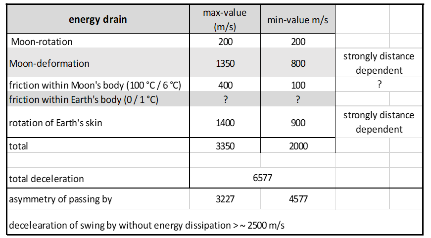
Table 1 | List of the loss mechanisms and the energies considered in analyzing the capture of the Moon.
The min- and max-columns reflect the estimated bandwidth of the respective braking effect.

Diagram 2
Exemplary computer simulation of the Moon’s capture by Earth
Transformation of geology and geography
Not only the Drake Strait and the adjoining South Sandwich Trench, but, also, all submarine canyons and the giant land canyons fit seamlessly into the model proposed. In line with our model, the huge Zhemchug canyon (see Figure A and Figure B) ends in the Aleutian Trench. Across the Bering depression, the Arctic Sea drained into the Pacific. Deep-sea canyons, which continue at the mouths of large rivers like the Indus or the Congo, are not in their origin related to the rivers which give them their names. Today, these rivers mark the main drainage channels of the continents. When the tide, generated by the near Moon, washed over the continents, the off flowing water drained along these predetermined directions and tore deep channels into the shelves inland and submarine.
How little deep-sea trenches and rivers are connected in their origin becomes obvious when such canyons do not form the continuation of a large river. For example, above the Monterey Canyon, the Salinas River, a mere creek, flows into the Ocean. And even such a creek is missing in case of the La Jolla and Scripps Canyon. It is obvious to associate these canyons to the Grand Canyon and the big salt lakes east of the Sierra Nevada. A gigantic water mountain flooded the western USA up to the Rocky Mountains. The backflowing waters dug the Grand Canyon and the submarine canyons off the coast of California. Seawater trapped in basins evaporated and left behind the salt lakes of today.
The lack of weathering of the flanks and the sharp grooves proves that the submarine canyons are geologically young. Their bottoms are not filled by mud and debris, and none exhibits dislocations due to plate tectonics.
Water alone has not transformed Earth’s face. The gravity of the Moon tugged at Earth’s atmosphere, which spontaneously gave way to the pull. A global hurricane caused by an unprecedented low raged and swept over the land, carrying along everything in its path. When in Siberia and Alaska paleontologists stumble upon heaps in which animal bones and tree remains are torn to shreds, wildly twisted and piled chaotically,9 the unpreceded storm deposited them there in the lee of a cliff. There, the permafrost prevented rotting and decay.
Not only air and water followed the pull of the Moon, whole plates of Earth’s crust were set in motion. The Andes represent the most conspicuous bequest. When the flood tore the Drake Strait, the Nazca Plate pressed itself under the South American plate and lifted the Andes into the sky. This makes the Andes an unbelievably young mountain range. It sounds crazy, but, the marine fauna of Lake Titicaca indicates that it was a former sea bay that was lifted to an altitude of more than 3800 m. The remains of a saltwater fauna, sea mollusks and seahorses still live in the lake today. The lake water is moderately salty with about 1 g/l and is drinkable. Lake Titicaca drains into Lake Poopó and Lake Coipasa, both of which are largely dried up salt lakes. Given a former effective freshwater inflow of 100 m3/s and assuming a permanent homogeneous mixing of fresh and saltwater, then, theoretically, the salt content would drop to the present value in 1500 years. (Today’s freshwater inflow to Lake Titicaca is small because the tributaries’ water is already taken for agriculture and other infrastructure supply before it reaches the lake.) To assume permanent homogeneous mixing is overly simplifying. Water stratification and a freshwater drain channel between inflow and outflow might increase the time of salinity decreased by other factors. Despite these unknown factors, we end up with geologically short times to wash out the salt.
The lifting of the Andes in the west triggered a seesawing effect regarding the continental shelf in the east. While in the west the Cordilleras rose, in the east the flat pampa dived into the Atlantic Ocean. Consequently, and in full accordance with this thesis, east of Argentina the continental shelf continues for several hundred kilometers into the Atlantic before breaking off into the deep sea. Only the Falkland Islands rise out of the shallow coastal waters like a memorial.
The Piri Reis map
Even if it appears to be conspiracy nonsense, messages from a distant past suggest the Moon became a satellite of Earth only after man already populated the world. Evidence for this thesis can be derived from an ancient map, which was drawn before the Deluge. With the Piri Reis map 10 shown in Figure E, we hold a document in hand which outlines the western coastline of the Atlantic Ocean in the pre-Flood period. The coastlines of the Piri Reis map fit too well with the shelf edge of the South American plate to be coincidental.
Dated 1513 the map was undoubtedly drawn using older, now lost templates. In 1513 South America was not discovered yet, let alone any idea of continental plates or shelf edges. The Piri Reis map adds an argument of a completely different nature to the above findings concerning geology and sea biology.

Figure E | Contour of the coastlines as shown in the map of Piri Reis (black lines) 11 laid over a modern geological world map. 12
Picture left: overlay without an adjustment of the projection
Picture right: approximate adjustment of the projection by stretching and compressing the Piri Reis map. The best adaptation of the Piri Reis to the West African coastline served as a criterion.
(Contour line sketch: PD0)
The faithful reproduction of some stretches of coast contrasts with grotesque deviations elsewhere. We think that besides the shelf edge of South America, the Piri Reis map also shows horrendous devastations in northern Atlantic. The region we call the Caribbean would have been part of the mainland of a continent or a Continental Bridge which connected today’s North and South America. Our model explains the disappearance of this land mass in a simple way. After rolling over South America and removing the Moon, the water bulge left back in the South Atlantic flowed in a broad current from the South Atlantic back into the emptied Polar Sea. The destructive power of this northward rolling wall of water demonstrates the Lorentz Canyon, see Figure A. In addition, a giant wave hitting from the west flooded the narrow Central America, which perhaps did not even exist yet. Likely, it was the crashing of the Cocos Plate against the Caribbean Plate which caused today’s isthmus of Panama to emerge above sea level.
Irrespective of whether this effect of isthmus elevation occurred, water masses from the Pacific Ocean flowed into the inland sea, referred to as the Gulf of Mexico and the Caribbean Sea. The pushed in water caused a flash flood to the east which tore up the land bridge. Present maps, which depict not only the mainland but also the seabed, suggest this former coast which stretched from Florida to Venezuela. As remnants, only the islands of the Caribbean rise out of the water. The Piri Reis map reproduces this far more easterly coastline.
If we suppose that the Caribbean Bridge is marked with a question mark, the depiction of the land bridge that once connected South America with Antarctica represents a more convincing proof for the Piri Reis map’s correctness. In the south, in the course of the move of tectonic plates, the Andes folded, and the shift of a tectonic plate occurred in the Drake Strait area. Colliding against the South American Plate its rim was squeezed into the depths. By this, the South Sandwich Deep Sea Trench got created with the ridge of still active volcano islands to the west.
That this former land bridge is more than fiction suggests a modern geological map that again not only shows the mainland but also the profile of the ocean floor. The ocean floor structure is in perfect agreement with our thesis that a huge tidal wave tore a former land bridge apart. The flow lines of this gigantic flow are recognizably retained in the profile of the seafloor of the strait. The tidal wave’s flow channel is also conspicuously preserved in the shape of the two embankments, South America to the north and Antarctica to the south, respectively. Gigantic in scale both banks extend in a characteristic sloped curvature far into the Atlantic Ocean (Figure F).
Looking at Figure F, the Piri Reis map confirms our model unmistakably. It does not depict today’s coastline, but credibly reproduces the contour of the coastlines at a pre-Deluge time. We feel vindicated in our interpretation of the Piri Reis map, i.e. that it maps a pre-history world.
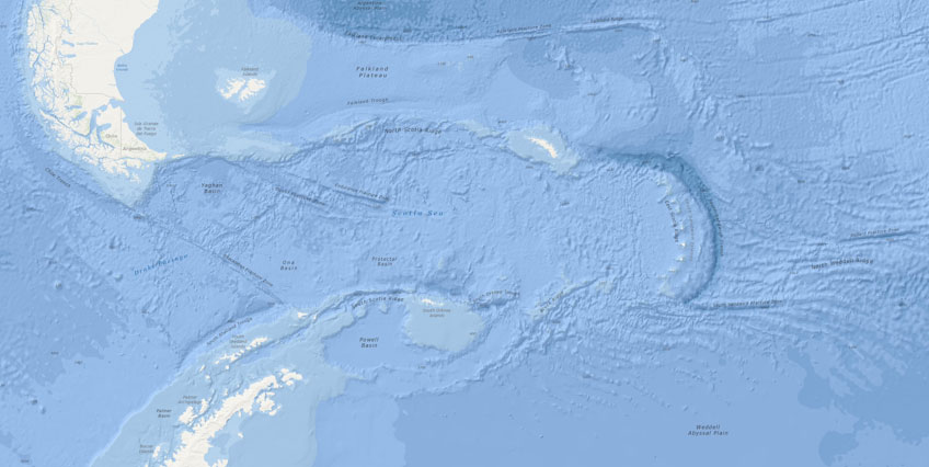
Figure F | Geography of the Drake Strait, which separates South America and Antarctica 13
The flow channel of the tidal wave which ruptured the Drake Strait open is still preserved on the seafloor. The same holds for the bent-away headlands that border the strait above sea level.
To the east, the volcano ridge followed by the South Sandwich Trench marks the transformation of this region.
(PD0)
If we accept the map to be a credible representation of a sunken reality, then we can assume that the big island in the middle of the ocean was the Atlantis of Plato. The island was washed away or sank into the sea when the passing Moon ripped up the continent and this cataclysm caused eastern South America to sink into the ocean.
Myths and sagas
In addition to the map’s elucidating precision, many supporting legends are found amongst native South and Central America cultures that detail a prehistoric catastrophe triggered by the Moon, where millions perished. Mayan myths that report on a flood that killed 64 million could be true, or at least contain a true core. In a secondary literature citation, a message in the Codex Troana 14 allegedly reads as follows: 15, 16
In the sixth year, may and in the eleventh Muluc, in the month of Zac, terrible earthquakes occurred which continued uninterrupted until the thirteenth of Chuen. The land of hills and clay, “the land of Mu” was sacrificed. After being raised twice, it suddenly disappeared during the night as volcanic forces continually shook the basin. Cut off as it was, the land rose and fell several times and in different places. Finally, the surface broke and the ten countries were torn to pieces. Unable to resist seismic violence, they sank with their sixty-four million inhabitants, eight thousand and sixty years before the writing of this book.
The message is concrete and fits our thesis. The double lifting of the sea is the normal tidal effect. Even though the close encounter lasted less than an hour, the Moon’s gravity acted for a far longer time span. Consequently, an increasingly higher tidal mountain rolled around the rotating Earth. Moreover, the movement of the water and land masses – once set in motion – did not end abruptly.
Less specifically, M. Brasseur de Bourbourg quotes Mexican legends about a great upheaval during which continents were flooded: 17
The forces that are currently in this stable equilibrium can, amplified or disturbed, become sufficiently strong to cause a sudden oscillation of the ocean that submerges the continent and in an instant wipe out the peoples who inhabit the lowlands.
Another echo of this cataclysmic event can be heard again in a myth from Peru. The story tells of a shepherd who had fled with his family to the mountains before the Flood occurred. Brasseur de Bourbourg quotes the report as follows: 18
No sooner were they there than the sea, whose dams broke under a terrible shock, began to rise up from the Pacific coast. But as the sea rose and flooded the surrounding valleys and plains, the mountain of Ancasmarca 19 rose like a ship on the waves. During the five days that this cataclysm lasted, no sun shone, and the earth remained in darkness; but on the fifth day the waters began to recede, and the sun gave its light back to a desolate world, which then repopulated by the descendants of the shepherd of Ancasmarca.
xIn this myth, we find the core of our model confirmed. The myth reports of the impact of the bulged waters of the Pacific Ocean and of the simultaneous uplift of the Andes. The occurrence is explicated by the allegory of a mountain rising like a ship in the surrounding water. The distance from Ancasmarca to the Drake Strait is 6,000 km where we assume that the Moon generated bulge stood highest. If the water in Peru stood 5,000 m high above sea level, in the Drake-Strait a height of 10,000 m becomes a likely value. In the myths, the beginning of the Flood is heralded by a hurricane, which is a concomitant of the increasing pull of the approaching pre-Moon on Earth’s atmosphere. Here the quote from the Gilgamesh epic: 20
With the first light of dawn, a black cloud came from the horizon; it thundered within where Adad, lord of the storm was riding. In front over hill and plain Shullat and Hanish, heralds of the storm led on.
The hurricane as a forerunner of the Flood is an integral part of worldwide myths dealing with the Flood. Van der Sluijs quotes here besides many others a legend of the Huichol Indians, which reports:21
“…a wind, very bitter, and sharp as a chile” heralded the arrival of the waters, when “a great flood drowned everything alive on earth .. and all the world was filled with water.”
The Bible states that the waters do not only pour down from above but that the springs of the depths also burst open as a result of the deformation of the Earth’s body. Hereto, a quote from Biblical Science: 22
On the other hand, the conception of the world is incorporated when, in addition to the occurring meteorological phenomena (Gen 7: 4, Gen 8: 2), the sources of the depth also break into the habitat (Gen 7,11, see Gen 1,2) and the upper waters pour down through the sky windows (Gen 7.11, see Gen. 1.7ff) (Witte, 1998, 136).
Pole shift
The moving tectonic plates and the related geological transformations of Earth described above were neither the only nor the greatest upheavals that Earth suffered in the course of the Moon’s capture. The capture of the Moon made the globe tilt provoking a second cataclysm within the cataclysm.
The shift of the poles by a tilting of Earth’s axis can be analyzed by a physical assessment. As mentioned above, a more than 5-kilometer-high water cylinder rolled against the coast of South America, and in the tow of the Moon, tectonic plates crashed against each other. These occurrences made the globe shaking and the axis tilting. A conjecture that we can confirm or disprove by physics.
The torque associated with the collision is calculated by the formula:
where  equals to the change of speed of the moon and r is the lever arm, which maximally is given by the diameter of Earth. (Simplifying the problem, we neglect the impact occurring at the opposite side of the Earth, which, largely moving across land, did not impact the globe comparably. The impact in the north would make the transversal torque disappear, but the total torque would increase).
Assuming that the impact of the tsunami and of the moving tectonic plate hit the South American continent shelf and acted there (see Figure G), we can derive a statement about the primordial position of the poles. From the Moon’s change of velocity of 3,350 m/s (see Table 1) and an ‘effective’ impact at latitude 50° south, the effective torque vector can be calculated:
As the computation of the above vector product shows, the globe tilted along the degree of longitude at which the impact acted on Earth’s body. If we assume the ‘effective’ impact location at the mean longitude of central Argentina and take today’s 23.5° inclination of the Earth’s axis as the distance measure (primordial axis perpendicular to the orbital plane of Earth), this moves the North Pole in the pre-Moon period to a position between the Baffin Islands and Greenland.
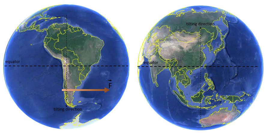
Figure G | Position of the primordial equator
The arrow  specifies the “effectively” acting impact.
The sketch simplifies a complex situation since, in reality, the force extended over a large area.
(Globe view shown by the use of Google Earth, Maxar Technologies).
The flattening of Earth at its poles caused by its rotation disturbs the symmetry of the sphere and defines a main axis of inertia. At a radius of 6,370 km, an equatorial bulge of 22 km is not a real obstacle to prevent the globe from tilting, especially since the rotating and in proportion dominantly viscous Earth immediately forms a new equatorial bulge in parallel to the pole shift. The formation of the new equilibrium geoid in the course of a pole shift means that the 22 km high deformation collar of an ideal sphere moves over Earth’s surface. If the height of the equatorial bulge in comparison to Earth’s diameter appears to be tiny, its shifting around the globe presents itself as a gigantic catastrophe in the reality of an earthling. The earthquakes associated with such a shift of the pole would be beyond any imagination. Depending on the position the earthquake magnitude of 10 (the maximum value on the Richter scale) would be exceeded easily.
The torque generated by the impact is by 40% too small to fully explain the assumed pole shift. However, this remaining difference does not contradict the thesis that Earth’s axis tilted during the capture of the Moon. Not sufficient to explain the full inclination, the impact was strong enough to initiate the tilting. Once the tilting got started, the in-plane angular momenta of the Moon’s orbit and Earth’s rotation can compensate each other. This balancing of the two angular momenta determines the angle by which Earth’s axis tilts.
Pertinent for our considerations, to connect the inclination of the Earth’s axis with the Moon’s angular momentum, is that the inclination of Earth and the orbital inclination of the Moon, respectively, coincide in their in-plane components of angular momentum. Hardly by chance, these two values match to such a degree to take their coincidence for proof. (When calculating the orbital angular momentum, it is considered that Moon and Earth (!) rotate around their common center of gravity so- called barycenter. Therefore to the angular momentum of the Moon’s orbit around Earth (2.6.1033 Nm.s) is added the orbital angular momentum of Earth (3.2.1031 Nm.s), stemming from it circling the barycenter.
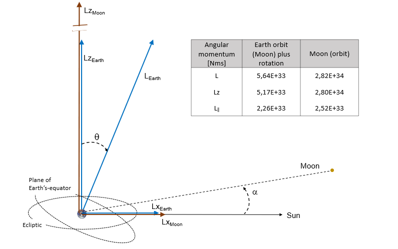
Diagram 3 | In-ecliptic components of the angular momentum of the Moon’s orbit and of Earth’s rotation
Angular momentum vectors of Earth’s rotation shown in blue, those of the Moon in brown.
Conclusion
We were able to present valid arguments for our thesis that the Moon is a young companion of Earth. Traces of this geologically recent capture characterize the structure of the Moon and exist on Earth as well. In fact, the combination of physical, geological and astronomical facts leads to a congruent picture that explains the current state of the Earth-Moon system and peculiarities in the geology of both celestial bodies without contradictions.
The temporal classification of the capture was achieved by reference to prehistoric news from different regions and cultures. In terms of time and as explicated in my book about an Alternative Prehistory, the capture of the Moon probably took place sometime between 40,000 and 13,000 BC. Globally existing myths report a cataclysm of enormous scale. Thereby, they report about disastrous concomitants accompanying the capture of the Moon. The capture of the Moon caused worse than a flood; it changed the geography of the world. Earth’s surface was devasted, millions died, and life in total was brought to the brink of extinction. In the collective memory of mankind, the event indelibly remained in the myths about a Deluge.
Literature
Robin M. Canup, Science (2012) Vol. 338, Issue 6110, pp. 1052-1055
Hancock, Graham (1995), Fingerprints of the Gods: The Evidence of Earth’s Lost Civilization. Three Rivers Press, New York
Charles H. Hapgood (1999). Path of the Pols. Adventures Unlimited Press, Illinois
Hans-Joachim Zillmer (2008), Irrtümer der Erdgeschichte. LangenMüller (München)
Eiling, Aloys (2020), Vergessene Zeiten, Vergangene Welten. Hibarios (Kaarst)
References:
1 R. Rufu, O. Aharonson und H. B. Perets; A multiple-impact origin for the Moon; Nature Geoscience Vol. 10, (2017)
2 https://commons.wikimedia.org/wiki/File:CanyonsbathyLG_USGS.jpg
3 http://michael.oards.net/pdf/Book/Chapter70.pdf, from Giant submarine canyons: Is size any clue to their importance in the rock record?
4 https://commons.wikimedia.org/wiki/File:Beringian_Margin_canyons.png
5 https://commons.wikimedia.org/wiki/Category:Submarine_canyons_of_the_Atlantic_Ocean#/media/File:Congo_canyon.png
6 https://upload.wikimedia.org/wikipedia/commons/9/97/June_2014_magnetic_field.jpg
7 Öpik, E. J Irish Astronomical Journal, vol. 3(8), p. 245–248 (1955) Available online at: http://adsbit.harvard.edu//full/1955IrAJ….3..245O/0000245.000.html
8 Sketch according to: https://www.thunderbolts.info/wp/2015/12/20/the-antipodal-moon/
9 https://atlantisforschung.de/index.php?title=Das_Ende_der_Eiszeit_-_Epoche_der_Katastrophen
10 Hertel, Gisa and Hertel, Peter (1984). Ungelöste Rätsel alter Erdkarten. Aulis, Cologne
11 https://commons.wikimedia.org/wiki/Category:Maps_by_Piri_Reis#/media/File:1513_Piri_Reis.jpg
12 https://upload.wikimedia.org/wikipedia/commons/archive/c/ce/20060315020829%21Atlantic_bathymetry.jpg
13 https://upload.wikimedia.org/wikipedia/commons/2/2e/Scotia_Sea_NOAA.jpg
14 http://www.famsi.org/mayawriting/codices/pdf/1_madrid_rosny_bb_pp.01-21.pdf
15 Translated quote from: http://www.atlantia.de/mythen/untergang/atlantis_maya.htm
17 Own translation of an excerpt from the book of: M. Brasseur de Bourbourg (1864) ‘S’il Existe des Sources de l’Histoire Primitive du Mexique’, p. 29–30
18 Own translation: M. Brasseur de Bourbourg (1864). Du Mexique dans le Monumenrs Egyptiens, p. 40. Available online at: https://archive.org/details/silexistedessour00bras/page/40
19 Mountain in Peru (height: 5198m) ~30 km north of Cusco
20 https://www.lernhelfer.de/sites/default/files/lexicon/pdf/BWS-DEU2-0194-01.pdf
21 Van der Sluijs, M. A. (2011) Traditional Cosmology, Vol. 4, Disintegration. All-Round Publ., London, p. 14
Congratulations on making astronomy accessible in your article. Could you add some explanation of how your proposed moon capture dating, accommodates the known last Ice Age factors? Was earth orbit larger? Did the impact start, disrupt, or stop the Ice Age? Could water and mud have been raised above the atmosphere as liquid ice, to fall back in phases? And making ‘fossils’ in the process?
In Africa are also some salt pans, and salt in craters such as the relatively young Tswaing ‘Salt’ meteorite crater north of Pretoria. Does its dating support your dating?
hi Aloys,
Wow. What an ambitious paper. I cannot comment on your calculations. I am no mathematician. But I too have marveled at the strange geology and underwater features of Drake’s Passage. Your hypothesis and your interpretation of the Piri Reis map is intriguing.
I agree with you about the importance of the submarine canyons. I first learned of them from the coral reef expert professor Ting Ma, whom I cite in the intro of my book Deep History. The canyons were not cut by river outflow, as fresh water is lighter than salt water. A glance at the map of the Amazon shows this. The Amazon enters the Atlantic with such force it flows for many miles out to sea. But there is no submarine canyon. The flow is on the surface. No question, these canyons must have been cut by backflowing water during earth cataclysms.
I wish I could read German. 🙂
Mark
p.s. Good luck with your book!
Reply to Edmund+Furter,
To answer your questions in brief.
As a result of the momentum transfer connected with the capture of the Moon the velocity of the Earth-Moon system increased by low 70 m/s, which led to an increase of the length of the year by 2 days. (Note: The orbit speed of Earth is about 30,000 m/s.) Thus, the effect regarding orbit change was minimal.
A consequence of the transfer of angular momentum in the vourse of the gravitational interaction, the pole shifted by 2,500 km to the present north. This had a huge impact on the climate situation of the regions. Ice age in America and Europe ended while Siberia became all of the sudden the most cold region in the north. The shock-frozen animals, mamouths are the best-known relicts, represent an evidence of this occurrence.
Although the globe bulged due to the gravitational pull of the traversing Moon, the force of the nearby Moon could not tear any material into space. Worst case small fragments of lunar body impacted Earth.
In the course of this cataclysm, in a giant tsunami salt water washed over the whole world. In this respect, salt pans re residuals which can be found in any drainless basin. The Twain crater is most likely of different origin. Its shape makes it a real impact crater of a meteorite. Given its age I assume it older than I date the Moon capture. However, on geological time scale ist age fits roughly.
For a better answer and on request, I can forward the relevant and translated (1) chapters of my book. Unfortunately, I have not yet been able to interest a publisher in printing it.
Absolute Brilliant
Thank you! A short but very kind comment. I’m happy to learn when my thoughts find some resonance
Monrad Joseph says:
Although the content is not always easy for a non-scientist, it shows new perspectives and gives room for new reflections. Especially since the author has published further books in which this topic links belletristic with scientific aspects. Here a new kind of literature has emerged that calls for continuation.Iam looking forward to more books,
Monrad
While browsing in a used book store – maybe 45 years ago – one book, I quickly read, supposed that the source of the various inhabitants particular to geographic locales around the planet was Antarctica. I remember it well, still wishing I had bought it, because, since then, various suppositions have conjectured that earth’s geo-history includes changes in tilt. Included in this book was such a supposition. The books premise was predicated on this assumption – that a shift in polarity had caused the continent, Antartica, now under the ice, to have been transformed from temperate to the frozen waste it is.
Certain regions of the continent would have been as far from the then pole as Toronto is today from the North Pole. I think there was a sketch showing outbound people sailing towards distant destinations and different locations on different continents. Given the magnitude of the catastrophe you conjecture, I cannot see how these sailors could have survived. Still the notion that such a deluge occurred and that anyone at all survived, must true.
For all that, it seems as though in the distant past there was a globe girdling catastrophe. There is plenty of evidence that people sought refuge in mountain fastness. And that remnants of ancient knowledges we have received in fragments remain. Knowledges that at one time were one cosmogony rather than fragments. I find Graham Hancock’s summation apt “we are a people with amnesia.’
Such a catastrophe as you propose would have left survivors without much of anything material to begin again. They would only have the contents of their minds. Perhaps this is why there appears some kind of rent in mans history with so little evidence of his ancient past. There are abundant clues! But it is as though a giant shook the contents of a vast library from the back of a cargo plane flying at 35,000 feet.
There are pyramids, henges, strange earthworks, myths, and natural monuments that seem to have sprouted willy nilly. The Hopi live in what is still about the most remote region of the U.S. Their myths are remembered in rituals they claim are ancient. The shapes of stone edifices at Chaco Canyon are odd. But they seem intentionally designed and built as though remembering something they wanted to recall.
Other ancient structures seem to have been built in locations around the planet intentionally located to convey something we are unable to decipher. Almost recalling notes in a musical scale. Hanging in my hall at home are Tibetan carved wooden masks
with a third eye in their temple. Tibet is there still — high and remote in recent memory. Well I am sure you are quite familiar with these scattered anomalies. There are hundreds more. What happened? How often has Earth been subjected to catastrophes we can hardly imagine?
Hi Aloys
That was 100% the most exciting and intriguing articles I’ve ever read. I have a few of questions for you:
1. Do you think this theory also accounts for/fits with the Younger Dryas impact hypothesis?
2. Why has the theory that the earth captured the moon (even in the beginning when earth was a proto-planet) been largely dismissed? What is it about your maths (sorry, I couldn’t follow those parts) that is better than the work that did not convince scientists at the 1984 Hawaii conference?
3. Why does the scientific community widely accepted the giant impact hypothesis? It doesn’t seem like it’s exactly a well-evidenced hypothesis.
Hello Michale,
I assume you refer ‘Path of the Pole: Cataclysmic Poleshift Geology’ by Charles Hapgood. You can download it at https://archive.org/details/eathsshiftingcru033562mbp/page/n19/mode/2up. If my estimate of the location of the pole before the tipping of the Earth’s axis is correct, the South Pole was in fact on the rim of Antarctica, south of Australia (about the longitude of Perth). Generally, I agree with you. We don’t really know our own (pre)history.
Hi Samm,
Thank you for the positive assessment of my article. Regarding your questions, you will find almost all of them answered in my book. Sorry, only available in German. I have translated it into English, but have not yet found a publisher.
To your questions a few brief comments:
1. the meteorite impacts of the Younger Dryas have no direct connection with the Moon capture, but are of a more recent date. The assignable craters range from North America to Europe (Helgoland Hole). Given the extent of the crater field, fragments from a huge, disinintegrated asteroid also must have crashed also into the Atlantic Ocean, causing devastating tsunamis. I suspect that these tsunamis wiped out the early megalithic cultures in Northern Europe. The saga about Phaeton may represent a dark memory of that event. In fact, Ovid’s description (http://classics.mit.edu/Ovid/metam.2.second.html)looks quite apt.
2. I am not familiar with the Hawaii conference. Here my thoughts reagarding your question: There are two main arguments against the capture model. First, the probability of capture is very low. The pre-Moon must appraoch Earth exactly in the narrow capture window at which it is captured but not impacting. Secondly, since the specific density of the Moon is very close to the density of the Earth’s mantle, the conclusion that the Moon is made of Earth mantle material is simply too tempting. That this conclusion represents an intellectual contraction has struck some scientists. What curious arguments are used to explain the differences in the isotope ratios of rock is meanwhile ridiculous. Moreover, more sophisticated scenarios no longer fit into the picture of the simple impact model, see e.g. R. Rufu, O. Aharonson and H. B. Perets; A multiple-impact origin for the Moon; Nature Geoscience Vol. 10, (2017).
The key arguments in my reasoning are the dissipative processes involved in the close encounters. This is not so much math but physics. My math used to describe celestial mechanics is brute force numerics, which describes the mutual acceleration of gravitationally interacting masses on the basis of Newton’s law of gravitation.
3. this question seems to me to be part of the question above. However, I like to point to the biggest problem associated with the assumption of a geologically recent capture. In fact, an object whose orbit extends from the asteroid belt to the Earth’s orbit can run on this orbit for millions of years at best but never for billions of years. The probability of an impact with Mars or Earth is simply too high. Therefore, the Moon capture becomes a puzzle piece of a far larger cosmic event that once has afflicted the planetary system as a whole.
I have presented this overriding picture, again quantitatively, in my book. May be, I will outline the triggering event in a future lengthy paper. Sorry for the moment!
Otherwise I am available for questions and discussion. Feel free to contact me any time.
Hi Aloys
Thank you for taking the time to answer my questions. Yes it’s a real shame that a publisher hasn’t been interested. Based on your article it seems like it would be a fascinating read. Unfortunately my education in German stopped at Year 9, so I only really remember the swear words and numbers!
Do you think we will ever be able to reach an evidential threshold where we know how the moon came to be? For the Younger Dryas Impact hypothesis, for example, I understand that we have the same evidence of widespread impacts as we have for the KT impact, which similarly took a long time to persuade those scientists who don’t believe in catastrophic events. Is there anything that could take a noon formation theory over that line?
You wrote in your article that you would place the event at 40,000 to 13,000 years ago. The later date would coincide with the YD impact, which some have cited as the cause of megafaunal extinction and, potentially, sophisticated civilisation(s). But you seem quite sure that the events are not connected. The 13,000 ya timeline fits with Plato’s timeline and with an extinction level event and your theory is neat and answers a lot of questions that the YD impact hypothesis can’t (like ‘where is the Atlantis land mass?’), but something definitely left impact proxies and the black stratum at 13k. Do you think there were two deluges? Or that YD did not have the impact that its proponents think it did (i.e. that we’re seeing the evidence of the moon capture and ascribing it to the YD impact)?
Samm
Edit:
Sorry, you already said that you think impacts in the Atlantic would have caused catastrophic tsunamis to wipe out Northern European cultures. I suppose what I’m getting at is do you think that the moon capture, and not the YD impacts, was responsible for the loss of an Atlantean civilisation?
Hi Samm,
Exactly. On the Piri-Reis map, an island is drawn that corresponds in location to Plato’s description. Note that inmy model not only this island, but the entire east coast of Central America was reshaped by the hyper-tsunami caused by the Moon.
On the other hand, fact is that an asteroid striking into an ocean can flood continents. Such an impact theory was championed by Austrian geology professor Tollmann, see https://www.zobodat.at/pdf/MittGeolGes_84_0001-0063.pdf
Unfortunately, again in German, but with an English abstract and with pictures which explain the whole model.
I like to point out that my intention is to establish a hypothesis and initiate thereby a discussion. I am as little as someone else in possession of the ultimate truth and all explanations.
Hi Samm,
The request to know something to 100% sure is a very ambitious demand. I would be already satisfied if the belief in the formation of the Moon as the result of an impact would falter. Neverteheless, I think that the explanation of the origin of the submarine canyons has a similar quality as the KT line has. The scientists only have to get used to the new idea. In science a joke exists that new theories do not prevail by convincing, but by the death of the old teachers. The insistence on the old doctrine can take peculiar forms. In the case of Galileo it is known that an opponent refused to look through the telescope only to be able to keep his old opinion.
The time span, in which I put the Moon capture, is certainly too large indicated. Since there was, as said, a celestial pre-event, which I put around 50,000 B.C., the Moon capture only can have took place later. But all this timing is vague. 13.000 B.C. are a fairly late date, but it explains better that myths and a map (Piri rice) were passed on up to our time.
Yes there are at least two floods. The first one was caused by the capture of the Moon and the second one was caused by impacts of a fragmented asteroid in the Atlantic Ocean and Northern Sea. Later, in the myths the two temporally separated events were interwoven up to the unrecognizability. For a stratum the mass of the asteroid might have been too low or its chemical composition was too unspecific.
By the way, if you like well founded crazy ideas you shoukd read my frist article on this webside (https://grahamhancock.com/eilinga1/).
Aloys
Hi Samm,
Exactly. On the Piri-Reis map, an island is drawn that corresponds in location to Plato’s description. Note that inmy model not only this island, but the entire east coast of Central America was reshaped by the hyper-tsunami caused by the Moon.
On the other hand, fact is that an asteroid striking into an ocean can flood continents. Such an impact theory was championed by Austrian geology professor Tollmann, see https://www.zobodat.at/pdf/MittGeolGes_84_0001-0063.pdf
Unfortunately, again in German, but with an English abstract and with pictures which explain the whole model.
I like to point out that my intention is to establish a hypothesis and initiate thereby a discussion. I am as little as someone else in possession of the ultimate truth and all explanations.
Dear Aloys,
thank you for sharing your most interesting and well researched work. The great Ralph Ellis in his book “Thoth, architect of the Universe” points out that Avebury in the UK has stone arrangements inside the circle that match the 7 islands at the top of the Drake straight. Have you looked into Ralph Ellis’ work? I am going to go and reread that part of the book with your findings in mind.
Dear Gunter,
is not known to me, but highly interesting. Thanks for the hint. I will definitely check his book.
Bought the book and read it. Interesting! Thanks again!
Hi Aloys
Great read. I have been looking into the early history of earth and found your paper when looking for changes in the earths surface. Your theory makes a lot of sense to me, that is a major change in the south, no doubt world changing. A lot of myths (history) survive from or past, thinking if the earth got her moon during our history there would be myths of this new light in the sky. That would be in the stories. Could the capture have happened before man.
Thanks for making me think
Dan
Of course, from a geological point of view, the capture may have occurred before the appearance of Homo Sapiens. But not many millions of years earlier. The well-preserved deep-sea trenches are icompatible to such a timing. Indications of a Moon capture in human times are weak, but exist. To mention are: The mythical preselenes of the Greeks and the Egyptians, Mesopotamian Moon god, the myths of South America and geologically (!) the state of Lake Titicaca.
The horror of the Flood burned itself far deeper into the human psyche than the new sky light. For those who experienced the capture of the Moon in the northern hemisphere perhaps even at night and who definietely had crawled into a cave to survive the storm, the connection was not obvious. The cataclysm was the dominant event in memory, the Moon was normality already for the next generation, struggle for life was not.