


This journey into the depth of unknown would not have been possible if there were not giant’s shoulders to stand on.
According to the cataclysm theory, the earth was flooded at around twelve thousand five hundred B.P (before present time) and sea levels rose somewhere in between one hundred to two hundred meters, which indicates that most of our history would lie underneath the sea. Many free-thinking archeologists of modern time are working from this theory. I decided to have a go at it. From my caravan, armed with a computer and the internet, I set off…
Now, I have not finished school and know nothing about archeology. I have not read any of the books of religion or great philosophers, so you can say I started off fresh with a clean slate. All the material I’ve been sifting through has been very detailed and sometimes tremendously speculative. I will try not to go too much into details, but sometimes ponder on highly speculative topics. I will also spare you from some of the details that the once that do this on an every day basis know by heart. The names have been altered through history and I will try to keep it simple. The ancients are said to have a great sense of humor, loved puns and liked their symbolism. That’s why I’ll try to use those as a guideline. So bear with me as a layman of many trades as we embark on this extraordinary adventure. One month hooked in front of my laptop trying to solve an ancient riddle. It has been a quite humbling experience. And I can say this much:
– You do not think you’ve discovered Atlantis – You know!
Strap your self in… Here we go!
Part 1:
The reef and the constellation.
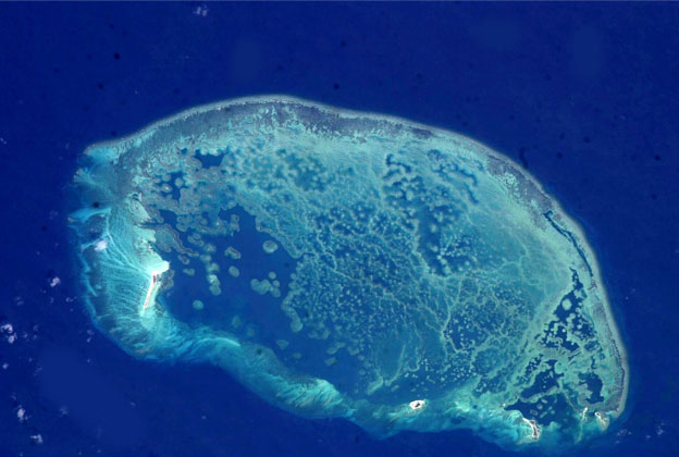
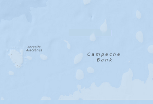
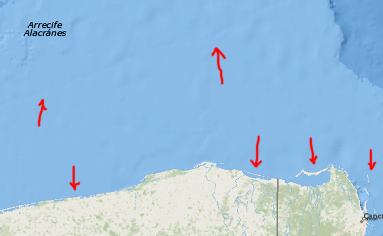
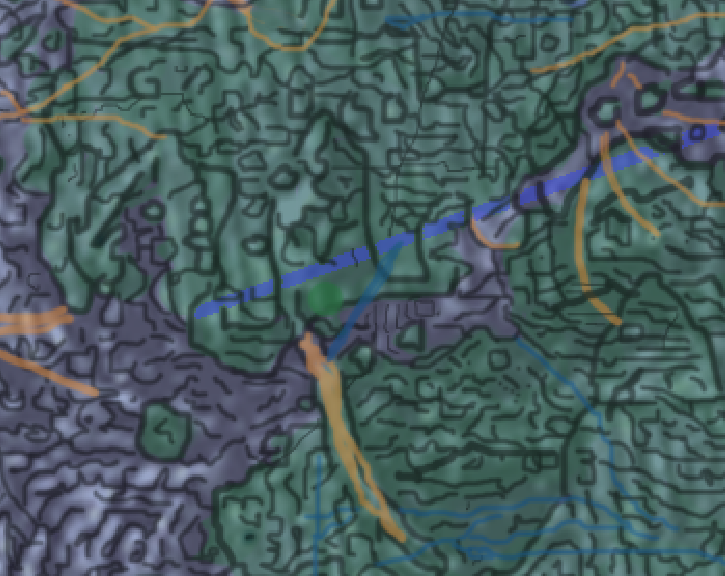
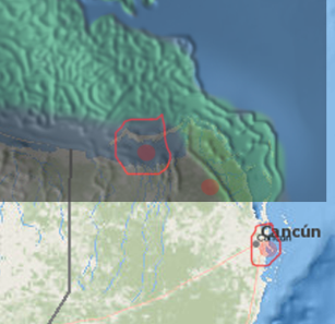
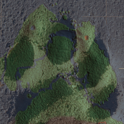
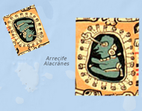
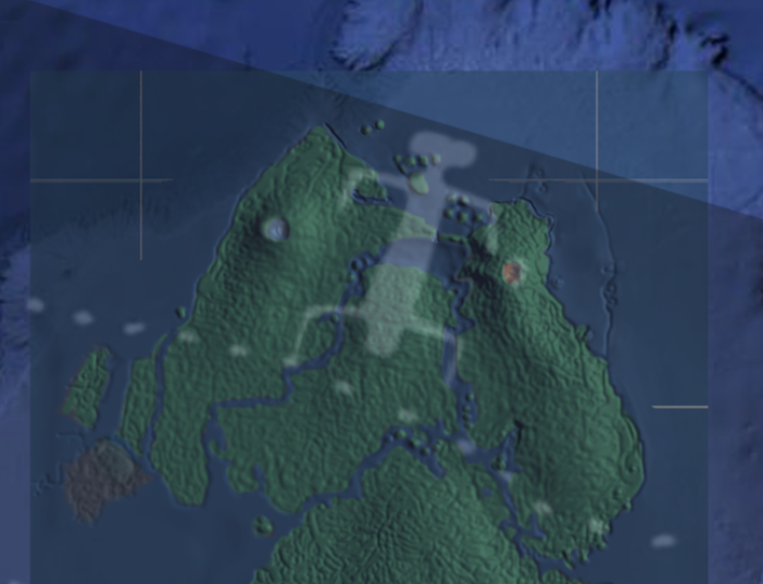
Picture 1: Arrecife Alacránes on the Campeche bank north of the Yucatán peninsula.
It all started with this reef in the Gulf of Mexico. It looked very peculiar. Like it had a wall around it, with an inlet/port, on the bottom right hand side, and this caught my attention. The reef is called Alacránes – the scorpio reef. Why is a reef called scorpio? Could there be any other scorpio connection on the mainland? I found one, the scorpio temple in Cancun. I did not find a direct connection between the reef and the temple in any literature, so I had to try something else. If the new findings about the pyramids from guys like Robert Bauval and Graham Hancock, that they are lined up with Orion is correct, then, why not try the most obvious one, the constellation of Scorpio. I fiddled around with it for a while, and then…this!
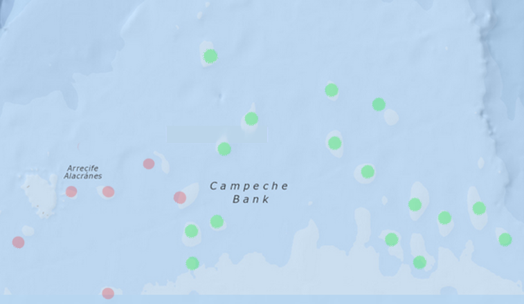
Picture 2: Constellation of the Scorpio.
Almost a perfect match! Too perfect to be a coincidence. Notice the submerged islands in the sea on the, lower, right hand side. They are at a depth of, somewhere in between, a hundred to two hundred meters and it is possible that they once where above sea level. So what does this mean? That some people terra-formed the earth to fit the constellation, or that they made up the constellations according to their immediate surroundings? I decided to check out the seabed and saw that the reef looked like this.
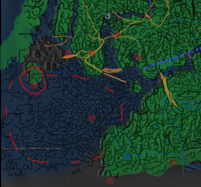
Picture 3: The strange reef
Looks a little too man made to me. Notice the small, raised dots around the reef, very symmetrical. What about the rest of the bumps on the seabed? Well, how about trying out the rest of the major stars in the Scorpio constellation?
Picture 4: The rest of the major stars in the constellation.
They match too. What could this be? I started to check out the history of the Yucatán peninsula and the only thing I found was that the Mayans called it: Maya’ab – The few. The few? Where did the rest go? What had happened here? No records of any kind of something laid out perfectly to match the Scorpio. It was like there was a complete sunken civilization that no one had any idea about. Where have we heard that before? If there are no records of it and no one knows it exists, then there could only be something to be found in the myths. They found Troy, didn’t they? I decided to check out the Atlantis myth. The first thing I found was Plato’s Critias dialogue, a somewhat fragmented story of Atlantis, but it mentioned several things about the outline of the “Island”, or archipelago that could help. There should be twenty-two islands. The bumps at the seabed seemed to match that number. There should also be a handmade trench, at least ten kilometers in length, leading from the city. Maybe the strait depression going northeast from Alacránes could be it? (Previous picture) Somewhere in the myth there is mentioned, Ultimo Thule. Could that be the Tulum terrace?
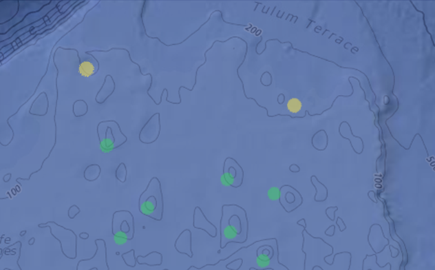
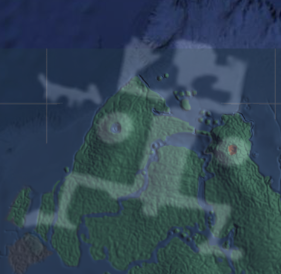
Picture 5: Tulum terrace and the volcanoes.
At this point I started to shiver. Just a small distance from the terrace I found two large, round, holes that could be the two volcanoes mentioned as well. At first I thought the hole on the right hand side of the yellow dot to the right was a volcano, but I have moved the dot to where I now believe it should be. Then at the atlan.org I found a long checklist of what was supposed to be found at the site of the mythical island:
The clues.
Atlantic Location
Sort of…
Navigation / Irrigation Canals
Plato mentions canals leading through the whole peninsula. Maybe this could be it?
Picture 6: The canal and the terraces.
Terraced Mountain Cultivation
Along the coast there are “piers” or what could be the remnants of terraces? According to an old Smithsonian survey of the reef and the Campeche bank it seems like the whole ocean floor is made up of rock formations that runs parallel to the coastline. So the terraces continues under the “mud”?
Elephants (Mammoths?)
If we’re talking about twelve thousand years ago, it could be possible.
Size Continental
Huge, but not continental sized, but that depends on how you see it.
Tropical Climate
Yes.
Coconuts / Pineapples
Probably.
Perfumes and Incenses
Why not?
Large Population
The few? Plato said something around a million.
Horses and War Chariots
Probably washed to sea if there was a flood.
Human Presence at the Epoch
Looks like it.
Megalithic Construction
Not right there (what we know of for obvious reasons), but in the vicinity. But if Plato is right, there should be.
Volcanism and Earthquakes
It’s sitting right beside a tectonic plate.
Sunken Continent
Could be.
In navigable Seas
Many islands and reefs. Probably.
Beyond Pillars of Hercules
The volcanoes? Maybe they mean Gibraltar.
Outer Continents Beyond
Yes.
Many Islands Beyond
Yes.
Site of Paradise (Eden)
“Gilgamesh reaches the Gates of Paradise, where he is stopped by the Scorpion-Men who guard its access.” – Epics of Gilgamesh
Evidences of Cataclysm
If it is submerged, it could indicate some sort of cataclysm.
Pyramid Cult
All over the peninsula.
Sargasso Sea Beyond
Now that is a funny story that I’ll come back to later. The same Smithsonian survey mentioned Sargassum, a kind of kelp that grows on and around the reef. But it is beyond the Sargasso sea as well.
Transoceanic Commerce
Too early to tell, but he ship I will mention soon may somewhat confirm this.
Riches in Metals
Has always been around the Mayans and in that area.
Superior Technology
I will mention it very soon.
Sacred Geometry
Lets start with the possibility of something matching a constellation. But the answer is…probably.
Holy Mountain and Volcanoes
If the sea levels rose about two hundred meters, then the whole Yucatán peninsula would have been a mountain.
Date Compatible
Well, it must have been before the flood/cataclysm. I figure it could be at least twelve thousand years old.
Two Crops a Year
As far as I know about agriculture it could be possible at that site.
Metals
In the myths they mention something called orichalcum -a rare alloy, second only to gold among the ancients. They found a ship outside Sicily with ingots of orichalcum in 2015, so that part of the myth is confirmed.
O-Blood Group
I will get to that in the exodus part.
Writing / Alphabet
Several.
At this point I was quite convinced that there was a slight possibility of this being a probable site of something resembling Atlantis. So I decided to press on. Unemployed – too much time on my hands, and with a hunch. Why not? On the plateau of the peninsula there are evidences of old rivers, so there could have been rivers to support a huge agricultural area. So I went on a scavenger hunt. Sifting the net for more clues.
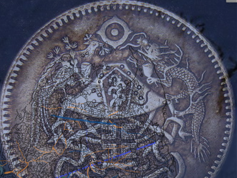
The map coin
I found this coin that caught my attention.
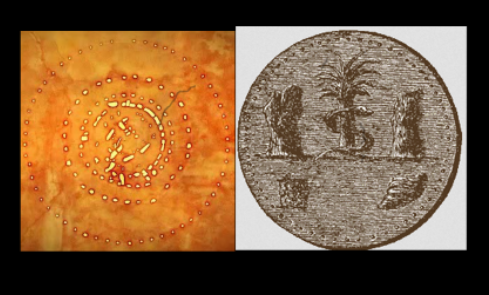
Picture 7: The mysterious coin/map. I do not know its name or what it is. I found it on the Internet with no reference. I asked Graham Hancock about it and he answered: The artifact looks familiar but I don’t know its name.
If there is one thing I have a keen eye for, it’s patterns. The coin seemed to fit in somehow. All the strange lines and dots are like a raster that converts vectors into dots, in for example, a newspaper. I’ve been working with 3D programs for about fifteen years now, and I know what a height map is. And this looked just like one! I could not find any reference to what the coin was, but a friend of mine had been telling me about the alchemical/hermetical saying: As above so below. So why not try to match it to the seafloor? I put it in a spot where it seemed to fit and changed the opacity so I could see through it. Then something remarkable happened. Some of the lines almost lit up when they matched the contours at the bottom. If I focused on a spot on the seabed and then slowly turned the opacity up on the coin, there where lines that sort of lingered.
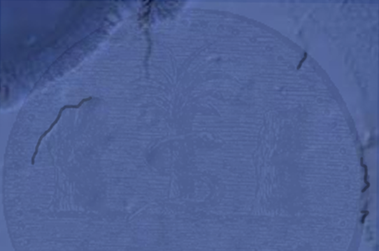
Picture 8: The coin map with 7% opacity.
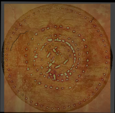
I went on filling in the visible lines that correlated and when I could not find any more lines I turned the coin and resized it. More lines! The patterns started to fit in with each other, and the more lines I drew, the more I got.
Picture 9: Close up of the coin. The orange lines indicate pieces of roads I found.
After, about a million or so changes in opacity and as many lines drawn, I came up with this:
Picture 10: The (almost) finished map.
This is what I’ve produced after two weeks in to this weird world of Alacránes! I’m not diagnosed with anything, because I have never seen a “someone” who wants to glue a diagnosis upon me and pump me full of strange concoctions, but at this point I needed a reality-check, so I sent some of the material to Graham Hancock. He was in the middle of a book release, but took his time to answer. That really helped me along. Throughout my time on this planet I have seen and experienced a lot of strange coincidences and phenomena’s, so to stumble into this wasn’t too weird. I’ve been searching both high and low all my life for the right answers to a lot of stupid questions. But this one I wonder. Will it straighten out any question marks or just replace them with even more entangled entities?
I stopped and marveled over this for a while. Anyhow. If you check out the “map coin” you see a lot of small dots, or lumps, at certain spots. Could this have been some kind of map that you put in a machine, like this one?
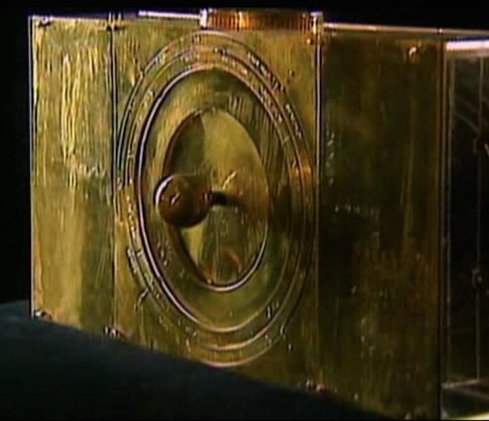
Picture 11: A device found at an excavation. Screen shot from history channel. Ancient aliens series.
Could it be that you turn the dials to get bearings, and even a view of what’s ahead? I tell you. This is something very sophisticated. I have always kept an open mind to weird possibilities, but this is highly advanced. I started to look closer at all the pictures I’d checked out on the internet, and found more artifacts with the small dots and lumps. Maybe they where maps to?
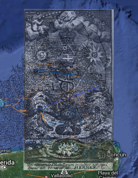
Picture 12A:The Philosopher’s Stone, symbolized by a bird in a triangle, rests atop the caduceus of Mercury in Le Triomphehermetique, by A. T. de Limojon de Saint-Didier, 1765.
The lines just melt together in a strange harmony. It’s all in the geometry. I have not yet figured out how they should be turned in the right way, but it seems to be in a Fibonacci sequence. Only thing. I have to find the point of origin. Me? I’m not very much into numerology; at least I wasn’t until this fell into my lap. The universe in which we live has always been a great fascination to me, but not enough to learn too much about astronomy, or astrology. This is why, during this cyber expedition, I also had to take a crash course in those subjects, and many others as well. So I believe that there are some nice, highly specialized “freaks” out there that can verify or throw away some of my wildest mind melts. Now I have to get back to the coin and make a small reflection. In old stories they tell about Charon that ferries the dead over the river Styx. To be able to get there you have to put two coins in the eyes of the dead. Could it be that this is the kind of coin, so that they had a map? I can only speculate. But what about the “cogs” on the outer rim of the coin? They are almost identical to Stonehenge. The rest of the coin harmonizes quite well too.
Picture 12b: Stonehenge and the coin with the same pattern.
Picture 14: Overlay of both pictures
So, it is a map then, and a star chart? I deem this to be very advanced and thus would prove that the ancients had advanced technology. I’d tick the box in the checklist.
The map
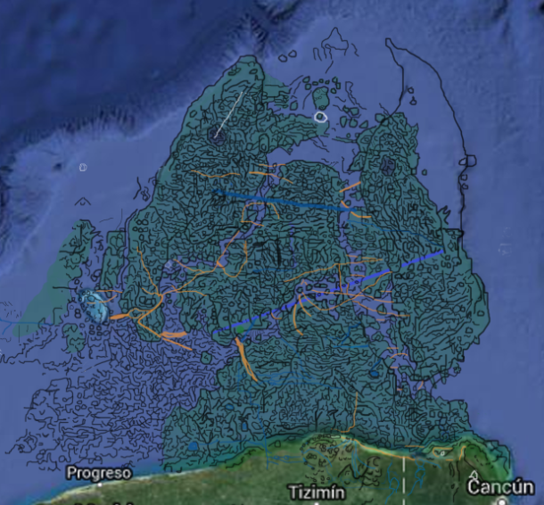
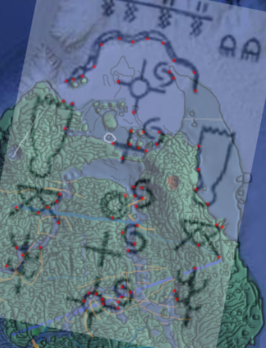
To pinpoint all the names and descriptions of “the navel of the universe”, it’s easier if you have a complete map. And when you do, it feels like a magnet that just draws everything into place. I put my flat drawings of the Campeche bank into a 3D modeling program and this is the result.
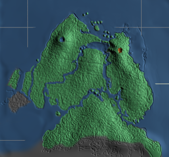
Picture 15: First 3D model of the peninsula.
“How shall I establish my words? And what part of it can be truly called a remnant of the land that then was? The whole country is only a long promontory extending far into the sea away from the rest of the continent, while the surrounding basin of the sea is everywhere deep in the neighborhood of the shore.” – Plato
All around the islands there are drops into the ocean that are over three thousand meters deep! Homer and Hesiod spoke of the “circular ocean” that surrounded the whole (ancient) world. If all that is marked in red is the “supposed” coastline of that time, then the whole Gulf of Mexico would have seemed like a circular ocean. Notice the “terraces” all the way up to Houston.
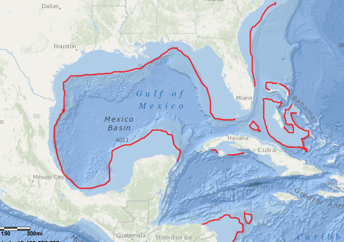
Picture 15b: The gulf and the possible coastline before the cataclysm.
The names.
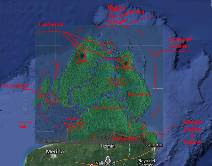
Now we can start to pinpoint the names associated with Atlantis. Here is a small checklist:
Ultimo Thule
Ys Brazil
Hades
Hell
Eden
Paradise
Lyoness
Avalon
Cerberus
Cush
Punt
Red sea
Sea of reeds
White isles
Fields of Elysium
Oceanos
Sargas (so) sea
Antares
Hephaestus – Volcano / warm water springs
Athene – She who fights in front / bright-eyed / Cold water springs
Trident
City of the pillars
Serpents
Dragons
The Seven Isles of the Blest
Lets start with the constellation of the Scorpio. There are two stars in the constellation called Al-Niyat, which means “the arteries”. They are located here:
Picture 16: Al-Niyat “the arteries”
Right where there is something that looks like terraces. Maybe there where waterfalls there? There are a lot of dried out rivers that leads to those points, so it’s a possibility. Antares (Anti Ares – against Mars the “war god”, (so they where pacifists?) is placed in between those two and is also called “The heart of the scorpio”. The next star with a name is Girtab, meaning scorpio. It also has a second name. “Sargas”. Nowhere I have found any good explanation to why it is called that, but when you look at the map the lines become very jittery, which could mean shallow water full of kelp. Sargassum. Maybe that is why people have been looking for Atlantis in the Sargasso sea? The Elysian fields it has also been called. Lyceum or, the boxthorn plant (goji berries) is known to thrive in bracken water.
Picture 17: Girtab/Sargas encircled and with the probable Lyceum fields.
The Elysian Fields were, according to Homer, located on the western edge of the Earth by the stream of Oceanos. The western most stream of, what I believe to be the mainland, has its outlet right there. Fields of Lycien = Lyceum plant with fertility – Scorpio is associated with fertility.
“Lyceum species mostly occur in arid and semi-arid climates, and a few are known from coastal zones in somewhat saline habitat types.” – Wikipedia
“As they are leaving, Utnapishtim’s wife asks her husband to offer a parting gift. Utnapishtim tells Gilgamesh that at the bottom of the sea there lives a boxthorn-like plant that will make him young again. Gilgamesh, by binding stones to his feet so he can walk on the bottom, manages to obtain the plant. Gilgamesh proposes to investigate if the plant has the hypothesized rejuvenation ability by testing it on an old man once he returns to Uruk.”
‘There is a plant that looks like a boxthorn, it has prickles like a dog rose, and will prick one who plucks it. But if you can possess this plant, you’ll be again as you were in your youth.’
‘This plant, Ur-shanabi, is the “Plant of Heartbeat”, with it a man can regain his vigor. To Uruk-the-sheepfold I will take it, to an ancient I will feed some and put the plant to the test!’ – Epics of Gilgamesh
Punt. Around the whole Yucatán peninsula there are a lot of places they call Punta: Punta Holchit, Punta Maroma, Punta Molas, Punta Celarain and so on. There are at least a dozen more. Could this be why they call it Punt? The middle most river passes a village called “Las Coloradas” – The red river. So this could be the red sea?
Picture 17b: Las Coloradas exit to the Campeche bank.
Then we have Cush. Scholars like Johann Michaelis and Rosenmuller have pointed out that the name Cush was applied to tracts of country on both sides of the Red sea, Cush = Campeche bank? It has also been called the white isles; maybe because of the volcano that spewed out ash which turned the islands white from time to time, or that the sand along the coast was white? The ash is a very good fertilizer and this could be one of the reasons why they could have two to three crops a year.
“Hephaestus attempted to rape Athene, but she eluded him. His seamen fell to the earth and impregnated the soil.”
“In fact, these two mountains are twin volcanoes, and the liquid they hold is that of crater lakes. They represent the symbolism of the twin Pillars Hephaestus and Athene,”
“And these two principles, one masculine and fiery, the other one feminine and moist are indeed the one represented in the yin-yang, in the Cosmic Egg, in the Ardhanarishvara (the androgyne) and in the Twins of all mythologies. It is these two sparks, these two opposite principles that our ancestors ingested in Paradise: the flesh and blood of their own sisters and brothers.” – atlan.org.
Fresh water from Athene, a died out volcano with a crater lake, and the fertile ash from Hephaestus (The roman equivalent is Vulcan). Maybe they even cremated their dead in the volcano, then they literary where eating the flesh and blood of their sisters and brothers.
“Do this in memory of me”, they say, the two Great Gods who indeed represent Atlantis.
“… in memory of me?” – Would that suggest that they wanted their people to worship the fresh water and the fertile soil? That the twins are so closely linked together as to be seen as one? The particles in the ash also bind the moisture in the air, which makes it rain. The Atlanteans was said to have liked that a lot. Sea of reeds. I can imagine there would be a lot of reeds in that shallow water. Ultima Thule – The Tulum terrace. I have mentioned that earlier. The term Ultima Thule in medieval geographies denotes any distant place located beyond the “borders of the known world”. But they also associated the islands with Hades and Hell. As a sea faring people I can imagine that leaving the safety of the shallow peninsula and sail over a three thousand meter drop in the ocean could be similar to a hellish world. In this picture of a metal plaque (which is also a map) that used to be in father Crespi’s collection, which of nothing remains to be found, you can see a serpent right at the drop. With a little imagination you can also see that the markings on the ocean floor could represent feathers – The feathered serpent?
Picture 18: From the collection of Father Crespie – The plaque with the “pope” and the serpent.

Picture 18b: Picture of a serpent eating a man, from an Aztec painting, and the “feathered serpent” in the deep. Screen shot from Michael Tsarion’s – Where history ends.
As I realized what kind of symbolisms they used, it got a little easier to pinpoint some more. They call it Lyoness and Avalon, which both refers to as “an island of lions”. Here I have two possible answers to why:
Picture 19: The whole “Cush” with a lions paw print laid over it.
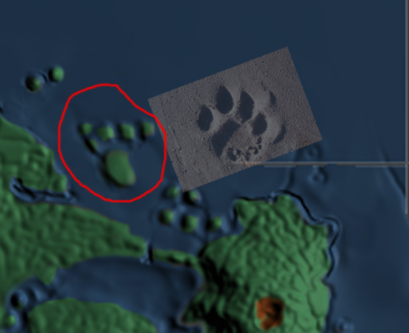
Picture 20: The northern most tip of “Cush” with the paw print.
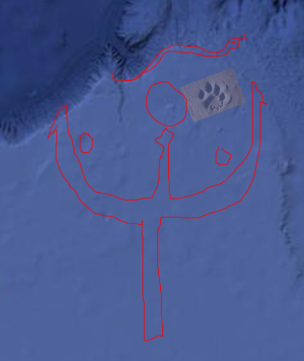
Picture 21: The real paw print, the feathered serpent and the trident.
I think this is why it is called the trident. Athene is given the curious epithet Tritogeneia – From a trident?
The serpent and the dragons trail:
Three? Hades? Hell? Who’s watching the entrance to Hades? Cerberus! The three headed hellhound with a serpent’s tail, a mane of snakes and paws of a lion. Cerberus is mentioned together with the Atlantis myth and has a phallic symbolism as well as the scorpio. Could this also mean that the feathered serpent is the deep/killer and the snakes are the seas and rivers? This makes me speculate if the Hydra (hydra – hydro – water), with its seven heads could represent the seven seas? Just check out Michael Tsarion’shomepage about serpents. I’m starting to believe that the serpent “cult” around the world is, amongst other things, a reminder of the cataclysm – Lest you forget…In ancient times the forces of nature were referenced to as a great dragon or a serpent.
This Island of Fire was also often called “Brazil” or “Ys Brazil” by the Celts and other nations (Yggdrasil?). Yggdrasil was the Ash-tree (Ha, ha…ash!) of the old Norse Edda and its roots were eaten by the Nidhog serpent. It is also said that there was three “Nornír” that watered its roots and put white sand on it. (The white isles?) The Mayan tree of life is very similar to Yggdrasil.
So it’s seems to figure. The tree is made of ash – i.e. the fertilizers from the ash of the volcano. I will try to add just some of the different folklore, because there is a lot that’s adding up to this equation.
“Hence the origin of the Grecian myth of the Hesperides (Hephaestus) garden and the fire-breathing dragons which guarded it/ – William Ricketts Cooper” (/The Serpent Myths of Ancient Egypt/)
O.K. So that explains this coin then. Yes, it is a map too.
Picture 22: The “Asian”-style coin. Notice the sign in the middle of the picture. I’ll get back to thatin the “Symbolism” part. Found it on the internet no references.
So then we have both the serpent and the dragon. Can that be…– Goji-berry = Gojira – (Godzilla) – God/Dragon? Fire mountain? No…that would be too easy…
Then what about Eden?
“Outside the Acropolis and under the sides of the hill there
dwelt artisans, and such of the husbandmen as were tilling the
ground near; the warrior class dwelt by themselves around the
temples of Athene and Hephaestus at the summit, which moreover they had enclosed with a single fence like the garden of a single house.”
“But in summer-time they left their
gardens and gymnasia and dining halls, and then the southern side ofthe hill was made use of by them for the same purpose. Where the Acropolis now is there was a fountain, which was choked by the earthquake, and has left only the few small streams which still
exist in the vicinity, but in those days the fountain gave an abundant supply of water for all and of suitable temperature in summer and in winter.” – Plato
So that could mean that they lived in the area of the red circle. In the summer time they went south. To where there were waterfalls? Eden is supposed to lay in between two streams and is often depicted with two waterfalls. Al-Niyat? I am not really sure about this location though, but for now…
Picture 23: Eden?
Then the layout of the land is starting to become clearer. Plato mentioned “the plains” and that it should be situated near the hand made ditch. It should also be rectangular in its shape. “The grove of Poseidon”, where they were planting their trees, is supposed to be found in-between the aqueducts where their access water would run out. If I have positioned “the hunting ground” right according to Plato, it will also explain why the dwellings of the warriors where completely enclosed with a fence.
Picture 24: The lay of the land
Paradise equals city of many pillars. This could be a reference to the pillars of law, but also, if it was a hugeport, it would also have many pillars. There are also mentioned twenty-two islands. When I saw this little fellah in the “codex Troano”, and counted the “dots/islands” around him, and turned it so that the “bridge” coming out of his eye matched the reef, you can almost see the bridge on the ocean floor. So the thing I saw in picture 4, on the bottom that matched the constellations, was just higher points in the terrain, not islands. But I believe that to be self-evident when you see these pictures.
Picture 25 – 25.1: The Troano picture and the reef.
This is how Plato describes the area around the reef:
“First of all they bridged over the zones of sea which surrounded the ancient metropolis, making a road to and from the royal palace. And at the very beginning they built the palace in the habitation of the god and of their ancestors, which they continued to ornament in successive generations, every king surpassing the one who went before him to the utmost of his power, until they made the building a marvel to behold for size and for beauty. And beginning from the sea they bored a canal of three hundred feet in width and one hundred feet in depth and fifty stadia in length, which they carried through to the outermost zone, making a passage from the sea up to this, which became a harbor, and leaving an opening sufficient to enable the largest vessels to find ingress. Moreover, they divided at the bridges the zones of land which parted the zones of sea, leaving room for a single trireme to pass out of one zone into another, and they covered over the channels so as to leave a way underneath for the ships; for the banks were raised considerably above the water. Now the largest of the zones into which a passage was cut from the sea was three stadia in breadth, and the zone of land which came next of equal breadth; but the next two zones, the one of water, the other of land, were two stadia, and the one which surrounded the central island was a stadium only in width. The island in which the palace was situated had a diameter of five stadia. All this including the zones and the bridge, which was the sixth part of a stadium in width, they surrounded by a stone wall on every side, placing towers and gates on the bridges where the sea passed in. The stone which was used in the work they quarried from underneath the centre island, and from underneath the zones, on the outer as well as the inner side. One kind was white, another black, and a third red, and as they quarried, they at the same time hollowed out double docks, having roofs formed out of the native rock. Some of their buildings were simple, but in others they put together different stones, varying the colour to please the eye, and to be a natural source of delight. The entire circuit of the wall, which went round the outermost zone, they covered with a coating of brass, and the circuit of the next wall they coated with tin, and the third, which encompassed the citadel, flashed with the red light of orichalcum.”
In this part of Plato’s work he describes the surroundings and mentions stadium or stadion, an old measure with at least ten different lengths to it, warring from. 177,5 meters up to 192,3 meters and not one of them fits the map I have drawn. But then we know that Plato might have changed the lengths just to conceal the real measures. To me it looks like a great undertaking and that they could house a great deal of ships. “They bored their way to the sea and quarried stone from the center island and around it”. This, so they could make docks and a passage to the sea. From, what I believe, they also had roofs over their docks made out of the native rock. Marvelous! The whole reef/center-island, and the trench, is transformed by the Atlanteans. There is also mentioned somewhere that there should be sluices. I believe I have seen something like that when I was working with the map. This could make sense. If they cut off the innermost parts of the archipelago, then they wouldn’t be depending on the tides. The triremes could navigate easily and all the water they needed for the sluices they could get from the same aqueducts and canals they transported their logs and fresh water on.
Seven islands of the blessed, comes from the fact that there are seven larger islands.And then I get in to the next part:
Symbolism/sacred geometry:
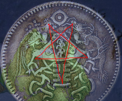
As I mentioned before: this spot just draws old symbols, numbers and names to it! Let us start with, what I think, is the obvious one. If you have names like Hades, Hell and trident, why not try this old symbol:
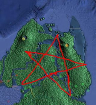
Picture 26: The pentagram and the “devil”.
Two of the lines are the aqueducts and the rest follows the constellation. I have no problems seeing a little devil with horns there as well. His cloven hoof in the myths might derive from the fact that the whole peninsula could also, apart from the lions paw, represent a hoof print. Why the star? They seemed to have worshiped all growing things, so why not worship a plant that gives tired, old men their vitality and libido back? This is what the boxthorn/goji berry flower look like:
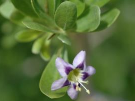
Picture 27: Lyceum/Boxthorn flower
“While most lyceum are monoecious, producing bisexual flowers with functional male and female parts, some species are gynodioecious, with some individuals bearing bisexual flowers and some producing functionally female flowers.” – Wikipedia
The Atlanteans seem to have liked balance, both in them self and in nature, therefore they have their androgynous references. They also held elections every fifth and sixth year, so that odds and evens wouldn’t get out of balance.
The boxthorn also goes through a fascinating transformation of colours on its way to maturity. Apart from the fact that the flower is purple, indigo and white, the berry goes through stages of yellow, orange and red. The whole plant is green and I bet there is some black and blue in there as well when the berry gets overly ripe. So the whole range of alchemical/chakra rainbow colours are represented in one plant, just a speculation from my behalf. But, hey, this is just a layman’s theory, which to me makes more sense than all the religions and myths combined. As a matter of fact, it actually makes more sense if you combine all religions and myths and make this the node with which you connect the dots. They called it “the navel of the universe” and “pillar of heaven”. The pole star on the southern hemisphere is Canopus. I think that you can probably work out how they mapped the whole world with the constellations. Once you have origo. But it is somewhere around this spot. O.K. So far it has just been a little weird. Now we enter the twilight zone. From here it just took off. Who made these tarot cards?
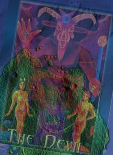
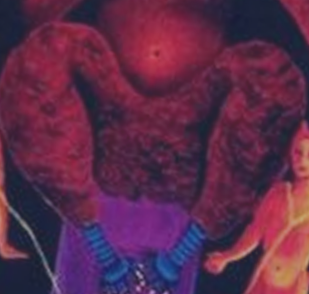
Picture 28: The devil – Tarot card
Changed opacity:
Picture 29: The devil – Tarot card and the ocean floor.
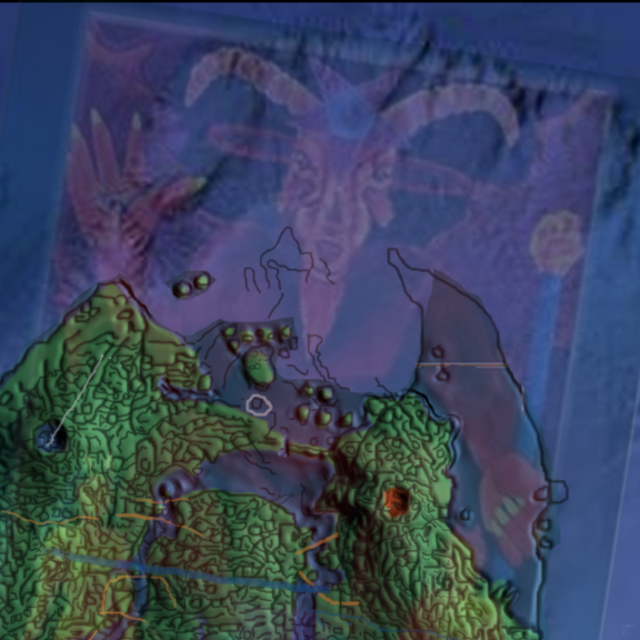
It has the same lines as the ocean floor and all the bumps on his wings and thighs just melts into the pattern. (It’s easier to see if you can switch the opacity on and off) How can this be? Check out the belly of the beast, and what’s below. Look like some kind of lines, holes and dots. That is not made to just look like fur.
It´s another height map. But how? This card is not painted twelve thousand years ago?
Picture 30: The devil and his belly.
So I put the 3D model underneath the picture and it’s a perfect match!
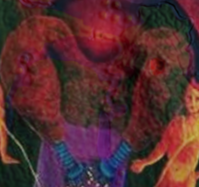
Picture 31: The devil, his belly and the 3D map.
It just accentuates the 3D impression. I can even see that his “veins” matches up with the rivers and roads when I turn on the outlines. All these pictures are from the Internet with poor quality and sometimes not from dead ahead, so the match is as good as it can be because of its tendency to drift over the distance. I would love to get my hands on some original photos and artifacts! I’m speechless. How old are these paintings? And how advanced where the ancients? By the way, the main cards in the tarot deck are twenty-two, same number as the islands. Here is another five-pointed star and a sun-symbol I found on the “Asian” map-coin:
Picture 32: The “Asian” coin and the up-side-down pentagram.
Picture 32.1: The sun symbol.
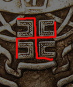
You can also draw the star through the dots and get it with the point up.In the middle of the star, there is this corn plant that caught my attention. I wonder if this is just a “coin”-cidence, but isn’t it the same, stylized corn plant on this tablet from the Hopi tribe?
Picture 33: The “Asian” coin and Hopi Indian tablet.
Then I tried to match the serpent on the back of the first tablet with the Tulum drop.
Picture 34: The Hopi tablet and the 3D map.
I do not know how many times a pattern has to tangent another pattern before it can’t be discarded as a mere coincident? This is, from this not perfect, map. It marks over seventy points, and the serpent… Spot on! The things at the sides of the volcanoes might be stylized calderas. The triangles are the sign for water (meeting earth?) and all corners seems to point at some water structure on the map.
How come that the Hopi and their tablets, have such a strong connection to Atlantis? They seem to speak of agriculture that made man strong, but then. Disaster struck. I have not figured the rest of them out, yet. The second to last picture on the Hopi tablet describes a “swastika” which is a sign representing the sun. You also have the moon represented. But they are mirrored and should have the moon on the other side as it represents the female Athena. It is easy to get side tracked when you open a “doll” and there is a new doll inside and so on. I will try to get back on track. Lets follow the tarot trail. I have been trying to check out as many temples as possible, especially those with names that fit, or have interesting frescoes. Tulum temple has a name that fits. It is also one of few temples made with a wall (in Mayan, Tulum means “wall”). It got christened just because of that wall. What if the wall represents the drop at the Tulum terrace and the drop represents the gate to Hades? Now that would be a twist. The temple also had a very interesting fresco right above its five portals at the temple of frescoes. Anyone noticed this one before? Is there a documented connection?

Picture 35: The hanged man at Tulum temple of frescoes.
Does this mean that the tarot cards has a direct connection to the Mayans/Atlantis? The next place with an interesting name in the area is the village of Molas. Molas is a kind of traditional garment made in intricate patterns and worn by different tribes. In an eerie way, some of them have a lot in common with the peninsula and the symbolism. The cross in the circle. The feathered serpent and a scorpio. Especially the stylized “Es” on its legs. If you check the head of the bird on the “Asian” coin, it too has something similar. I believe it is a pattern on the seabed that is represented.
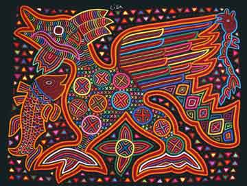
Picture 36a: Molas with the feathered serpent.
Picture 36b: Artifact from father Crespi’s collection. Looks like something from Mesopotamia and also the molas in the previous picture.
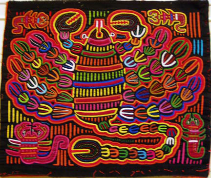
Picture 37: Molas with the scorpio and the stylized “Es”.
As the “land of the few” probably got completely wiped out by the cataclysm/flood, there is no surprise if you’d find the descendants of Atlantis somewhere else, like Panama. The Cuna tribe (Cancun?) is famous for their molas, and the tribe has not always been in Panama. They are the people with the lowest heart rate, which gives them very few cardio-vascular problems, and they have the, by far, the lowest amount of people suffering from cancer. They also have the highest number of albinos per capita, the white and blue-eyed people of Atlantis? The albinos are the only ones that are allowed to be out when there is a full moon. Lycans (Lyceum?) are associated with Atlantis as well. Maybe the ware wolf myth could have its origins from this? There are more similarities that would be interesting to check out. When I saw a documentary about the Cunas, I immediately focused on this one:
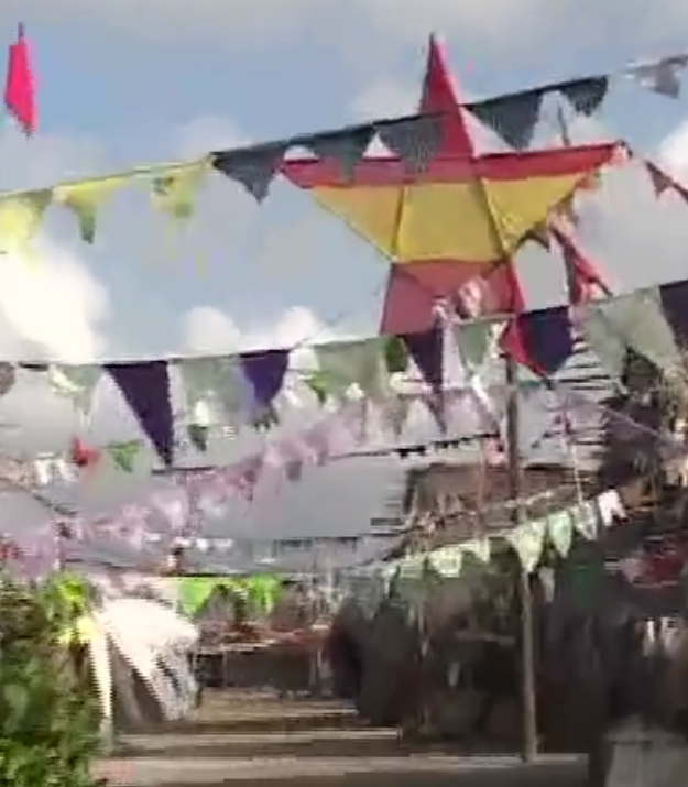
Picture 38: The Cuna village and the pentagram. Screen shot from Youtube. https://www.youtube.com/watch?v=clOoZZkTptI
And their flag looks like this:

When the tribe wanted independence they called their republic – Republic of Tule (Tulum?). Lets see… (Can)-Cunas, Molas and Tule(Tulum)? Three, or two and a half, names that could indicate something in the vicinity of this:
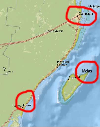
Picture 39: Cancun, Tulum and Molas
Molas was, by the way, a body painting that got banned by the church some hundred years ago, because they where naked. Then they started decorating the clothes they where forced to wear. Thus the relatively “new” trend with the sewn molas. The Cunas way of life seems to fit the way the Atlanteans tried to live. Balance is everything, the androgynous way. Well, this is just a reflection of a possibility, and following a hunch has gotten me this far. Where the “hell” that is? Talking about the abyss. What is this picture? Where does it come from? I wish it waspossible to find a better copy somewhere.
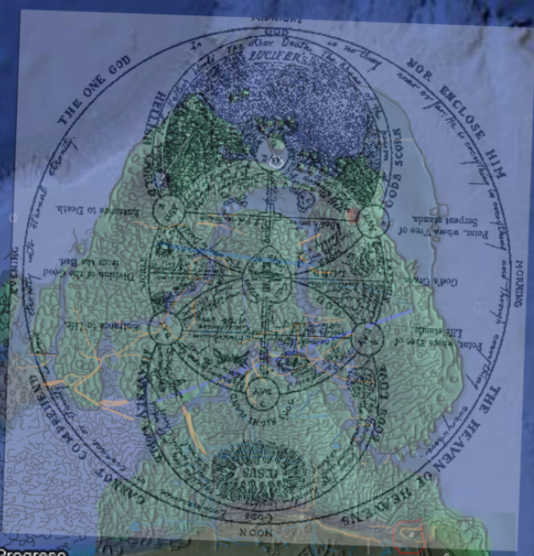
Picture 40: A kind of flow chart of…? Well lets call it “Heaven and hell” Found on the Internet, no references.
At the top of the picture, in all the black raster of the seabed, it says “Gods left hand” (the ocean?). It also says Lucifer’s something and “the abyss of the serpent”. Hmmm… And at the bottom it says “Gods right hand” (nature?). Seems fair. In the picture there are some other interesting things as well. In the red circle there is a drawn well, which is at the exact point where my blue line of the aqueduct ends. The red arrow points at the entrance to the hand-made trench. “Division of the Good from the Bad”. Why use capitol letters? Why is the “B” blocking the inlet and the “G” is granting access? They look like little sluices.
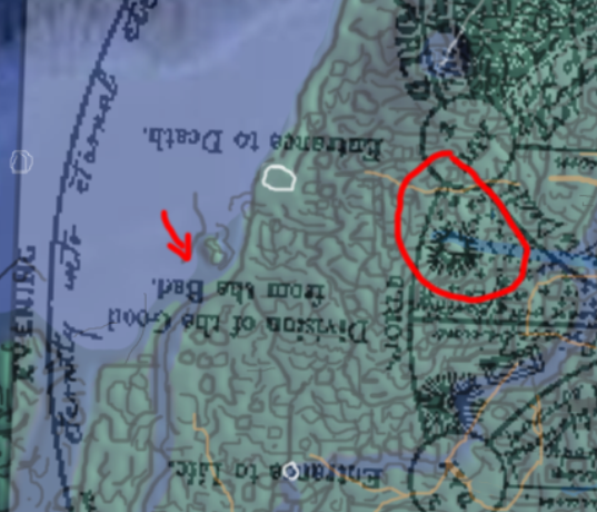
Picture 41: Close up on some of the details in the “Heaven and hell” flow chart.
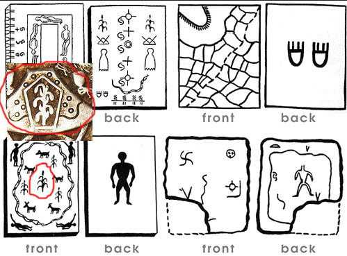
There are a lot of small interesting things that makes this one stand out, but unfortunately it is too pixelated to read the fine print, so I leave this one for now for a mind job that is global and then some. I am at this point fully convinced that I have found something that is extraordinary, even if only one piece of it is of any use. It has been a crazy cyber journey during a month and I have tons of new and interesting finds. If you think this is plausible, then I can tell you. This is just the tip of the iceberg, so to say. First you have to believe that the ancients where global, then, that they where highly advanced. I’m leaving all doors wide open to every possibility at this point. Then along the way I stumbled on this picture. A compilation of cave paintings. They have something in common, don’t they? The dots. They are also equally strange in their appearance. Feet/hands missing, weird symmetry, odd looking tails. What they do have in common, that we know of, is that they all come from different corners of the world.
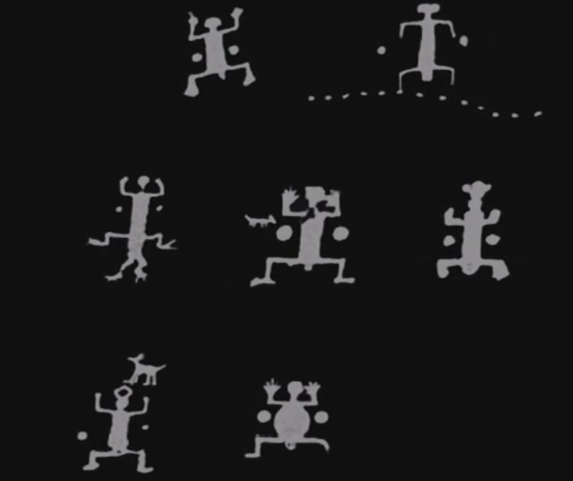
Picture 42: “The meaning of life, universe and everything” – Douglas Adams – Now S.E.P! Cave paintings from around the world. Screen shot from Ancient aliens series.
I thought to myself. Why not try to sync those dots with the volcanoes, just for fun? Look closely and judge for your self. See how the lines tangents certain details or just avoids them, but in the end measures the whole archipelago.
Picture 43.
Picture 44.
The dog has even got a face, with a nose, eyes and ears. And a longer tail!

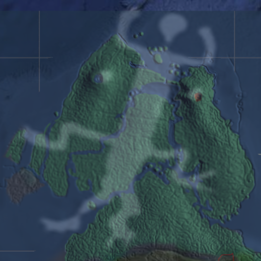
Picture 45: The dog
This one is brilliant! Marks the whole peninsula spot on. The fourth and fifth dot from the right marks the width of the canals. I like his face. Tongue sticking out. Is he resting in a hammock?
Picture 46: The perfect dots.
What is this? Some kind of a joke?
Picture 47: The Teaser
Best thing. I’m dead serious.
Picture 48: ?
The ancients, maybe not so serious… brings you hope. Or…?
All this seems kind of ridiculous. But when you think about it. If you where highly advanced and had to hide things in the plain open, wouldn’t you make it look so utterly ridiculous that no one would ever dream of getting the idea that this could be high-tech? Maybe they where only waiting for the technology and other things to be at sync and then put it all in the hands of a peace loving, truth seeking environmental freak and total lunatic who knows all the right tools, loves puns and has no hands on his time? All this I happened to stumble on and then it just grew. In the beginning I did not think I would get this far into these unknown waters, so I did not bother to remember all sources. I just took a screen shot of what looked interesting. Now I have backtracked and found the most of the sources, but not all. The map coins and some other pictures where just labeled with a number and .jpg on the world press. No homepage or anything. Even that is a mystery.
Thus ends part one.
Part two: (in the making)
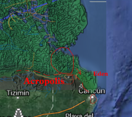
Acropolis
Atlantis
The fine print of the ancients
The empire
More symbolism
Global commerse
Cataclysm
Exodus
Aftermath
loved your E-research/journey looking forward to reading more of your thoughts on the strange history of this world,
thanks
Thank you Clark, I will continue…
Great work! You have a wonderfully fertile, creative mind. Thank you for applying it to this!
Thank you so much John. Your words inspire me to work harder at writing part two.
Brilliant research and fascinating how it all intertwines .
I am so pleased to hear that. I thank you for your kind words and I will try to connect some more oddities in this web of strangeness.