


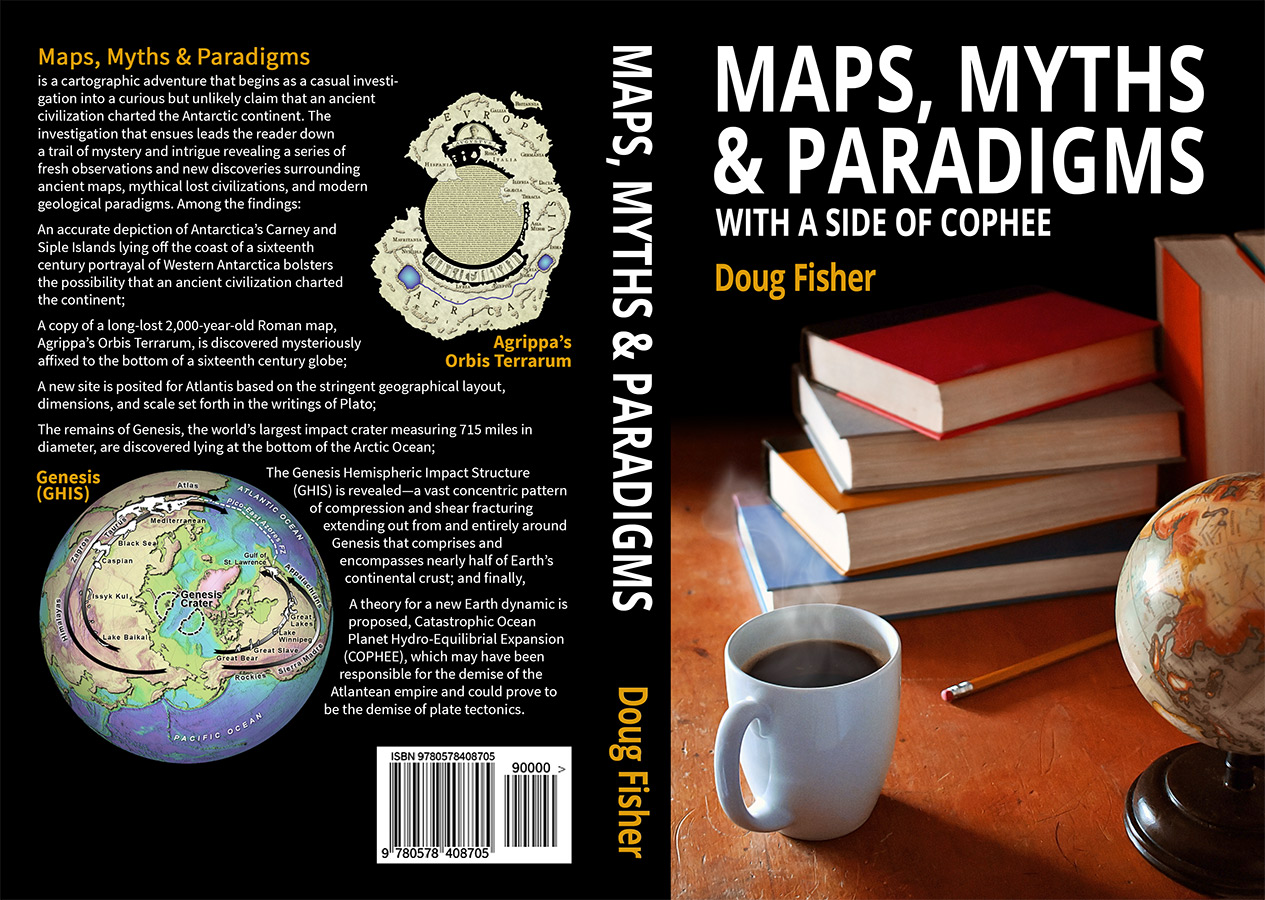

We warmly welcome Doug Fisher, author of Maps, Myths & Paradigms, as our featured author for October. Doug’s book is a cartographic adventure that takes readers on a deep investigation down the rabbit hole of mythical lost civilisations. Doug’s journey while writing this book led him to fresh discoveries surrounding ancient maps that compelled him to challenge modern geological principles. In his article here, Doug calls into question the prevailing and rigid plate tectonics paradigm and outlines his theory for a new Earth dynamic.
Interact with Doug on our AoM forum here.
Maps, Myths & Paradigms
Patterns provide one of the most vital interactions we, as humans, have with life. Identification and consistent interpretation of the patterns that surround us assist us in choosing the ideal path through new and uncertain environments. Still, we have been known on occasion to overlook a clear pattern of safe passage when attempting to reach an otherwise inaccessible but desirable target.
Such may be the case with plate tectonics and the desire to target the simplicity of a static Earth and steer clear of the unfamiliar and challenging physics required of an expanding Earth. En route to a static Earth, critical patterns were overlooked, inconsistently interpreted, and forced into compliance by the selective introduction of nonexistent geographical features. But the recent discovery of fracture-related patterns that lie strewn across our planet’s surface lays out a very clear, consistent, and unbroken path to a new worldview, a view that marks…
The Last Days of Plate Tectonics
My name is Doug Fisher, and I was featured in the Article section of this website back in 2010. Those submissions detail some of my findings regarding Atlantis, ancient maps of Antarctica, and the discovery of a long-lost Roman world map.
I have now published my book Maps, Myths & Paradigms, which includes and expands upon those findings in the book’s first half in a section titled Ancient Maps: Myths and Mysteries. While I believe I have provided some of the strongest evidence to date in support of a full-scale Atlantis site and the validity of ancient maps of Antarctica, it is clear that both will likely not be proven certain any time soon, if ever, and a healthy level of skepticism should always be maintained when considering the possibility of either’s legitimacy. Yet there was enough substance to warrant the second half of the book, Modern Maps: Paradigms and Puzzles, which details findings I discovered while advancing to the next logical level, seeking out a potential mechanism supporting an Atlantean cataclysmic event.
I went in with a fairly open mind, although, admittedly, I was leaning heavily toward the plate tectonics model. Because of this, I initially thought my discovery of a certain peninsula’s true origins would only further support plate tectonics. Ultimately, the evidence overwhelmingly favored a theory that was once vying for consensus alongside plate tectonics until the 1970s: the expanding Earth theory.
Those Who Invented Them, Subducted Them
There is a level of clarity that comes with developing a seemingly sound and cohesive alternative theory that allows one to view the prevailing theory through an entirely different lens. Suddenly, one becomes aware of suspect elements within a theory that were casually overlooked and left unaddressed by individuals, like my previous self, who are content with a theory that is extremely well supported and has both achieved and maintained consensus for most of one’s life.
The first of these suspect elements brings to mind a statement regarding the fabled island continent of Atlantis, for which the Greek historian Posidonius expressed his disfavor. The statement reads, “He who brought [Atlantis] into existence can also cause it to disappear,”1 i.e., the source of the story may have made an unfalsifiable claim that a continent-sized Atlantis sank in hopes of ensuring the preservation of fiction as fact.
In the images below, Earth’s surface is depicted as it is currently believed to have existed 165mya and today. The first image (165mya) depicts the world just as Pangaea begins to break apart. Pangaea existed about 200mya and was a consolidation of all of Earth’s continental mass to one side of the planet surrounded by a vast ocean of ancient seafloor crustal material. In many ways, it is reminiscent of the ancient Greek worldview that finds Europe, Asia, and Africa as the lone known continents consolidated together in the center of the world, also surrounded by an ancient ocean.
As Pangaea began to break up, newer post-Pangaean seafloor (PPS) crust began to form at the mid-oceanic ridges, slowly displacing older subducting Pangaean seafloor (PS) crust. We begin to see the ancient Pangaean seafloor crustal material incrementally displaced by new seafloor crust designated by small reddish-orange highlights (Fig. 1 c.165mya). This continues with the further infusion of fresh post-Pangaean seafloor designated by colors spanning the color spectrum from red, representing the most recent crust, to green representing the most ancient post-Pangaean seafloor material.
Amazingly, regardless of how truly random plate movements are believed to be, plate tectonics proposes the existence of ancient Pangaean seafloor plates at a time immediately after virtually every last bit has conveniently subducted beneath Earth’s surface (Fig. 1 0mya). Following the Pangaean breakup, the influx of new seafloor has somehow managed to completely button itself up around the continents leaving Earth’s surface completely devoid of ancient Pangaean seafloor plates. In other words, those who invented Pangaean seafloor plates subducted them.

Figure 1 – Those who invented Pangaean seafloor plates subducted them.
(Bottom: CC-BY-3.0)
Earth expansion and plate tectonics both maintain that all continental mass was at one time consolidated into a single Pangaean mass, and both maintain that little to no Pangaean seafloor crust exists today. The former maintains that it does not exist because it never did exist. The belief is that the Pangaean mass—today’s continents and continental fragments—once wrapped entirely around a smaller globe as a unified continental plate devoid of expansion basins—basins we recognize today as vast spans of seafloor crust—providing Earth with an initial surface structure similar to other planets.
Meanwhile, the latter, plate tectonics, maintains that ancient seafloor crustal material existed long before the world’s continental plates merged into the Pangaean supercontinent, and it is merely coincidental that thousands of miles of Pangaean seafloor crust have subducted, leaving our Earth currently devoid of this ancient crust. This belief in an invisible nonextant ancient crust is vital for adherence to a static Earth. We know that seafloor expansion has occurred to either side of mid-oceanic ridges, but for Earth to maintain its overall size, the overall surface area of the planet must remain constant throughout this expansion. Researchers, therefore, determined that older crust must be subducting at the same rate as new crust is being generated, thereby allowing Earth’s surface area to remain unchanged in size. The ideal proof of this theory would find Pangaea breaking up on one side of the planet and incrementally displacing older seafloor crust on the opposite side of the planet as the Pangaean plates shifted out across it. In this scenario, the entire Pacific would currently consist almost entirely of the ancient Pangaean seafloor crust.
Unfortunately, the current model creates a rather odd dichotomy. This is due to the remarkable expansion occurring on the opposite side of the planet in the very midst of the ancient Pangaean seafloor crust even as the post-Pangaean continents converge upon it (Fig. 1 165mya lower right PPS). Hence, we find on one side of the planet a supercontinent breaking apart with its fragments dragging new and expanding seafloor crustal material outward from mid-oceanic ridges, while on the opposite side of the planet we find a minuscule patch of Pacific seafloor crust appearing and launching itself in all directions toward these fragments. This small patch of post-Pangaean crust continues to expand until it successfully attaches to ALL external sides of the diverging Pangaean continents. And this complete attachment to external Pangaea conveniently occurs shortly before man arrives on the scene to assess Earth’s origins. Therefore, we arrive in time to find the same appearances of post-Pangaean seafloor attachment inside and outside of Pangaea, resulting from two vastly different dynamics. One would think it fantastical, yet plate tectonics requires us to have faith in this very miracle, a confluence of perfect timing and dual dynamics.
So, while Earth’s existing seafloor crust might initially suggest Earth expansion, plate tectonics successfully mutes this by proposing the existence of the nonexistent: ancient seafloor plates that miraculously and conveniently disappeared just as man arrived on the planet. This is Earth science’s ‘dragon in my garage’ moment being played out by ancient, invisible Pangaean seafloor plates. Celebrated scientist and author Carl Sagan, in his book, The Demon-Haunted World, 2 introduces the dragon in my garage analogy wherein one individual is found questioning a second individual claiming there is a fire-breathing dragon in his garage. When they look in the garage, the second man explains that they are unable to see the dragon because it is invisible. This is followed by several more attempts to verify its existence, but the man with the dragon counters each of these attempts by explaining why each has failed: There are no footprints because it floats, no heat signature for its invisible fire because its flame generates no heat, etc. Convenient unfalsifiable explanations thwart every attempt at verification.
In this same manner, not only does man enter the metaphorical garage just as ancient Pangaean plates have conveniently exited the planet’s surface, but we also arrive at the precise time when many readily observable geological patterns potentially refuting plate tectonics have come into perfect alignment. Based on current plate tectonics models, had man only arrived on the scene a few million years earlier or later, these patterns would not exist. In other words, much like the dragon, the strongest case for plate tectonics exists when man is not present.
A Fracture by Any Other Name
The expanding Earth theory I am proposing is based on evidence that is unlike any previously presented. This new evidence takes a fresh look at geological patterns that are directly linked to fracture dynamics. In what should prove to be one of the biggest scientific oversights of our time, Earth scientists have managed to completely overlook coastal ductile fractures. It is an astonishingly huge omission considering that continental plates are known to be ductile, a property that allows them to fold into mountains. Despite that fact, brittle fractures are the standard by which we currently define Earth’s coastal formations. Anyone familiar with plate tectonics and Alfred Wegener is likely aware that the recognition of patterns of brittle fracturing across the Atlantic, between Africa and the Americas, formed the basis for the theory of continental drift, the forerunner of plate tectonics.
This new theory revisits and expands that research by demonstrating how vastly different our view of Earth would be today if coastal ductile fractures had been acknowledged in the 1960s, the early days of plate tectonics when the Earth expansion theory was still in play. These findings will generate a renewed understanding of large-scale fracture dynamics and how they impact our planet, eventually ushering in a radically revised view of our planet. Researchers will no longer be stumped by the most basic fracture-related geological formations. Consider, for instance, the Nastapoka Arc, a very large, 270-mile-wide, perfectly formed arc cut into the shore of Hudson Bay, Canada (Fig. 2). Many had originally thought the arc was so well defined that it could only have been formed by a terrestrial impact, but researchers were later surprised to find that there were no signs of such an impact in the region.3 So the mystery continues with many, including a popular Jeopardy! champion and host, left exclaiming, “What could produce such uncanny geometry besides a rock from space?”
And yet the not-so-uncanny fracture arcs in ductile material (Fig. 2 bottom left) demonstrate how these arced formations occur naturally within ductile plates, a group to which continental plates belong. Based on this elementary observation, it seems odd that ductile fracturing has never been considered among the candidates defining the Nastapoka Arc’s origins.
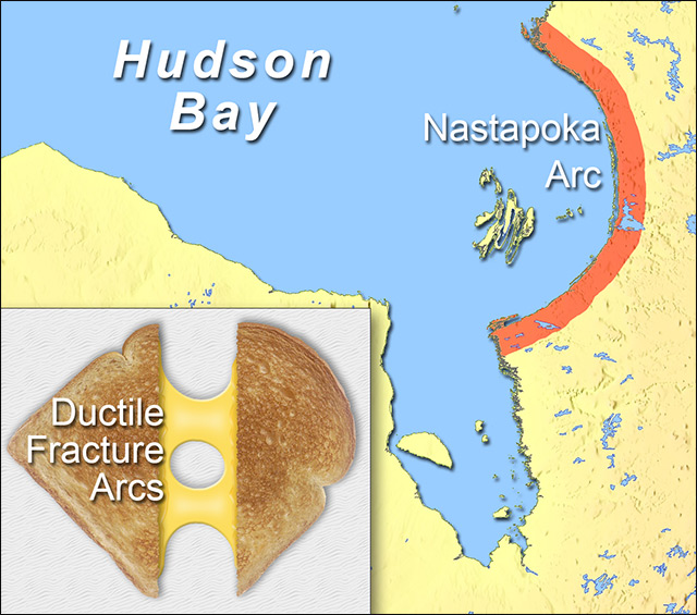
Figure 2 – Are the Nastapoka Arc’s origins truly that mysterious, or has Earth science simply overlooked a basic element of material properties?
(Background map: Modified image from the USGS)
What becomes extraordinarily clear is that Earth science, which fully accepts large-scale brittle fracturing in continental plates, currently remains unaware that ductile fractures exist as coastal formations at this scale. This odd disconnect may be one of the most surreal aspects of modern Earth science.
Earth science acknowledges that:
- The Nastapoka Arc exhibits a perfectly arced form,
- Continental plates exhibit ductile properties, and
- Continental plates are subjected to tension.
And experts in the field of material properties acknowledge that:
- Ductile fractures exhibit a perfectly arced form,
- They occur in plates exhibiting ductile properties, and
- They occur when plates are subjected to tension.
Yet over the last 50 years, since determining that the Nastapoka Arc was not created by a terrestrial impact, the two disciplines never managed to come together and posit the possibility that the Nastapoka Arc was a stress-induced ductile fracture. Thus, the mystery continues.
My introduction to ductile coastal fractures began with my investigation of the Kamchatka Peninsula, a peninsula located in eastern Russia. In line with what I stated at the beginning of this article, from the start, I had no reason to doubt plate tectonics, so when I began investigating the peninsula’s origins, I had every expectation that researchers had already noted the obvious fit between the peninsula’s western coast and the adjacent Asian coast. Initially, I found that the theory of back-arc spreading had been applied to the region. It is a phenomenon believed to be driven by subduction that ultimately sees back-arc basins, like the Okhotsk Basin lying between Kamchatka and Asia, expanding laterally toward a point of subduction, a point typically defined by a noticeable seafloor trench.
Surprisingly, however, plate tectonics models portray Kamchatka as having originated apart from the Asian mainland after the Okhotsk Basin began to form. Just a couple of decades ago, it was believed that it rose from the seafloor as a series of volcanic islands within the Kuril-Kamchatka island arc. These volcanic islands coalesced into a larger island that eventually attached itself to the Asian continent.4 Today, many maintain that Kamchatka consists of fragments that drifted in from the east and collided with the Asian continent.5 All these models overlook the perfectly conforming coastal recess along the adjacent Asian coast and the lone coastal points that perfectly align to form an isthmus when Kamchatka is positioned into this recess (Fig. 3 black circle top center). Therefore, plate tectonics not only imagines Kamchatka randomly landing adjacent to the only coastal pocket in the world that conforms to Kamchatka in size, shape, and scale with a perfectly aligning coastal point to boot, it also imagines the Kamchatka fragment randomly orienting itself in the one direction that would allow it to pivot perfectly back into the coastal pocket. Just another of many astonishing coincidences within the current plate tectonics model that is nothing short of miraculous.
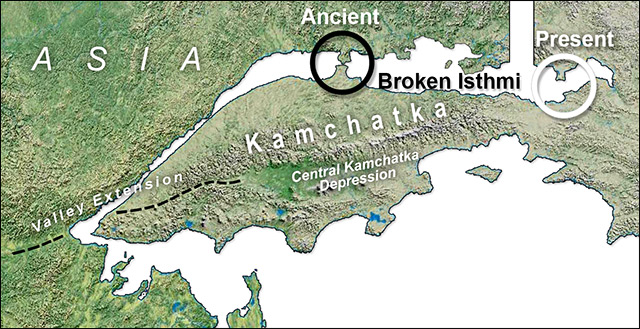
Figure 3 – Kamchatka Peninsula’s original fit proposed by the author.
(Courtesy NASA, Author modified)
Surprised to find that no one had previously addressed this obvious conformance, I investigated further and soon discovered the first of many continental coastal ductile fractures. These were discovered while attempting to reconcile the length of Asia’s coastline with the slightly shorter western coast of Kamchatka. Two arcing coastal voids on the Asian coast seemed to account for the discrepancy in lengths, and it was immediately clear that these were likely ductile tears or fractures (orange highlighted arcs in Figure 4).
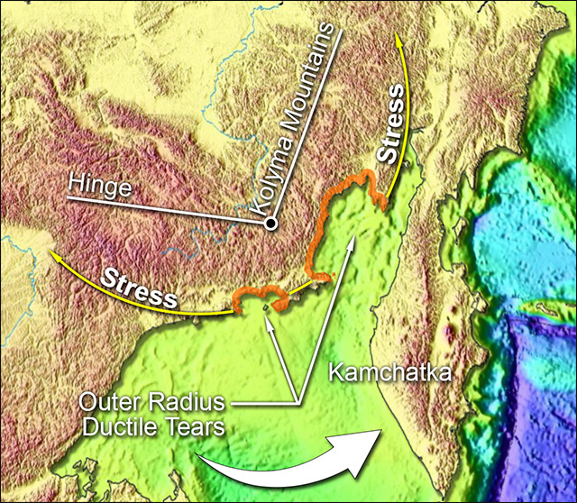
Figure 4 – Asia’s inner hinge, outer stress, and resultant ductile fractures.
(Modified image from the USGS)
Ductile fractures can appear as arcs formed where tensile stress has been applied to a ductile or pliable plate of material. Unlike brittle fracturing, which sees little to no deformation in rigid material, allowing fractured pieces to easily fit back together—e.g., a broken ceramic plate and the majority of Kamchatka’s western coast—ductile fracturing incurs substantial deformation in the form of necking and oval voids. Figure 5 demonstrates this extraordinarily common, basic, and natural phenomenon that we all encounter on a regular basis. In this image, we can discern the various ductile fracture formations using a very popular and highly ductile plate material, melted sliced cheese.
The two coastal voids on the Asian coast are ductile tears that lie directly out from a bend in the Kolyma mountains (Fig. 4), signifying that the stress creating these tears on the Asian coast was generated by the same force that caused the Kolyma deformation in the continental plate. The near-90° angle of the bend also mimics Kamchatka’s pivot out from the accommodating coastal pocket, further confirming the stress that plucked Kamchatka free of Asia.
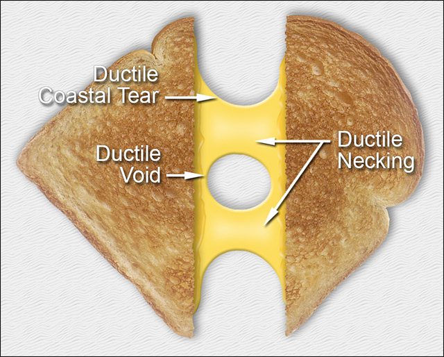
Figure 5 – The simplicity of ductile fractures demonstrated in a pliable, ductile plate material, melted cheese.
Further confirmation of Kamchatka’s extraction from the Asian continent comes in the form of ductile necking and fracturing exhibited in the four aligning coastal points (Fig. 6). Necking occurs as plate material is overextended and begins to thin (reference the two similar formations in Fig. 5). Narrowing of the neck continues until the material is stretched beyond its breaking point at which time the material fractures completely apart within the necking area. Necking is visible in the two coastal points extending off Kamchatka. These coastal points represent the final break from Asia.
Ductile tears in the sides of both coastal points extending from the mainland further confirm the arcing path of Kamchatka’s extraction. Both exhibit tears on the side opposite the direction of applied stress. In Figure 6, we can see the westernmost coastal point exhibits a ductile fracture generated by lateral stress while the easternmost coastal point exhibits a ductile fracture generated by vertical stress. The current back-arc basin via subduction theory could in no way account for these bidirectional stresses. Only Kamchatka’s 90° counterclockwise pivot out and away from the coast is able to fully account for these.

Figure 6 – Fracture patterns favor rotation over subduction and linear back-arc spreading.
(Modified image from the USGS)
Kamchatka’s true origin as a fragment of Asia would prove to be only the tip of a rather large iceberg. After discovering the initial ductile fractures associated with the Kamchatka pullout, it became obvious that ductile fractures were strewn all about the area indicating enormous stress put on the entire region as Kamchatka was being ripped free of the mainland. Kamchatka’s eastern coast is riddled with ductile fractures in the form of multiple arcs (Fig. 7, cusps A thru E) that extend all the way north as far as the Gulf of Anadyr (Fig. 7 between cusps F and G).
And once these coastal ductile fractures were identified, it was impossible not to notice that if seafloor ridges existed in the region, they perfectly and consistently aligned with the outstretched cusps of a ductile fracture. And these ridge-to-cusp alignments would subsequently prove to be a consistent global phenomenon. Seeing this, it is hard to imagine someone suggesting that every single one of these alignments had come about completely by chance with absolutely no correlation between seafloor ridges and continental fractures, and yet plate tectonics currently supports just that.
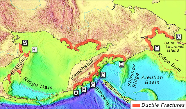
Figure 7 – Ductile fractures and seafloor ridge alignments located throughout the Kamchatka region. Are these consistent alignments the product of random plate movement or predictable fracture propagation?
(Modified image from the USGS)
The Hotspot Myth
Early on, researchers were perplexed by the discovery of seafloor ridges, like the Hawaiian-Emperor seamount chain, that extended out and abruptly truncated in the middle of a seafloor plate. In many instances, volcanic activity could be discerned at the truncated end of the ridge. The Hawaiian Islands are a prime example where active volcanoes breach the ocean’s surface at the farthest extreme of the Hawaiian-Emperor seamount chain.
The mystery of these truncated ridges appeared to be solved in 1963 when Canadian geophysicist and geologist John Tuzo Wilson proposed what would eventually come to be known as the hotspot theory.6 This theory proposes that invisible hotspots, residing at unknown depths within Earth’s mantle, generate plumes of superheated magma that rise up toward Earth’s surface and melt through the overlying seafloor crust. The linear seafloor ridges form as the crustal plates travel across the plume, allowing it to cut a path through the plate.
Unfortunately, Wilson and others fell short in their analysis of seafloor ridges because of a few major missteps. First, in line with their failure to recognize coastal ductile fractures, they failed to realize that these ridges, which should intersect random points along a continental mass, were consistently aligning with continental fracture points. These observations would have revealed the true origins of these ridges, confirming that they are not linked to subsurface hotspot activity but are instead linked to the planet’s surface and specifically to fractures occurring in continental plates.
In fact, these ridges were so obviously linked to continental plate fractures that they provided the clearest evidence to date that subduction, a necessity of plate tectonics, was not occurring anywhere near the level necessary to displace the ancient Pangaean seafloor crust. In Figure 7, it can clearly be seen that the Aleutian island arc (Fig. 7 D) and two purported hotspot ridges, the Hawaiian-Emperor seamount chain (Fig. 7 C) and the Shirshov Ridge (Fig. 7 E), align perfectly with the cusps of continental fractures. It is virtually impossible for one of these ridges, let alone all three, to have maintained alignment with their associated fracture points after the subduction of thousands or even mere hundreds of miles of Pacific seafloor plate material beneath the Asian Plate. Once again, like the complete disappearance of the Pangaean plates, this becomes another highly improbable random alignment occurring at an inopportune time for plate tectonics.
By overlooking seafloor ridge and continental fracture alignments, researchers were unable to grasp the true relationship between continental and seafloor crusts. Fractures occurring in continental crust propagate out onto the adjacent seafloor crust because the two crusts are fully bonded together from the moment seafloor crustal material comes into existence, filling the void opened up between separating or diverging continental plates and fragments.
A canvas frame provides the perfect example of this relationship. When the primary plate material—the wooden frame or continental plate—fractures apart, a V-shaped wedge opens up into the secondary material—the canvas or seafloor plate—since it is bonded directly to the former and follows the separating primary material (Fig. 8). The only difference between the seafloor material and canvas is that new material fills the seafloor void and ridges form a hardened magmatic bond between the two crusts. This V-wedge model is a consistent occurrence on the seafloor, though it is easy to see why this continues to be overlooked.
And this leads us to the final major misstep that Wilson and others have made. They limited their analysis to these ridges in their current truncated state. Had they rolled back time ~50mya, they would have found that all these ridges had once been paired and joined together at their associated mid-oceanic ridge. In Figure 8, we have gone back in time to 50mya, where we find plate tectonics models confirming that the truncated ridges in the Atlantic and Indian Oceans were once joined at their respective mid-oceanic ridges. In fact, from the time Pangaea broke apart until 50mya, all of these ridges expanded out from continental mass while remaining connected at their lowest extremity forming V-shaped wedges. This, of course, replicates standard patterns of fracture propagation.

Figure 8 – Like torn edges in a broken canvas frame, seafloor ridges are consistently aligned to fracture points.
(Lower left and right: Modified images from the USGS)
When You Hear Hoofbeats
There is an expression associated with the medical community, “When you hear hoofbeats, think horses, not zebras.”7 It is a form of Occam’s razor that essentially prescribes consideration of the most likely explanation before seeking out the more complex and exotic explanation. The temporary introduction and convenient disappearance of the ancient Pangaean seafloor crust represents one of these instances of a more exotic and nuanced concept. Another occurs with seafloor ridges where a clear pattern is broken with the Ninetyeast Ridge creating a glaring inconsistency, and once again, it appears to be another exotic interpretation necessitated by the desire to conform to a static Earth.
Revisiting the broken wooden frame, simple deduction tells us that we can easily piece the frame back together because we know that the two fracture points sitting at the top of the canvas wedge were once joined (Fig. 9 X1-X2 once existed as Fig. 9 XX) and this is exactly what occurs with these seafloor ridges. In Figure 9, we have gone back far beyond 50mya to the time of Pangaea, and we find that the current plate tectonics model agrees that the tops of the V-shaped ridges in the Atlantic and Indian Oceans were indeed joined together in much the same way as the fractured canvas frame. The upper ends of the Rio Grande Rise and Walvis Ridge reconnect Brazil, South America to Namibia, Africa (Fig. 9 AA), and the upper ends of the Mascarene and Chagos-Lacadive Plateau reconnect northern Madagascar to western India (Fig. 9 BB). This is a consistent pattern predicted by the fracture propagation theory.
In extreme contrast to these natural ancient reconnects, we can see in Figure 9 how the current plate tectonics model blatantly breaks this pattern within Pangaea with the insertion of a vast section of nonextant Pangaean seafloor crust, the Tethys Ocean, distancing the southern tip of Madagascar thousands of miles from Indochina (Fig. 9 C1-C2). By introducing this inconsistency and creating this vast gulf of separation, Eurasia, which is universally believed to have been attached to North America in the west at the time of Pangaea, was no longer required to be simultaneously attached to eastern Africa in the southeast, a feat that would have required a smaller globe. Inserting the vast Tethys gap has an effect akin to pulling a tightly fit softball cover from a softball and slapping it onto the much larger surface of a soccer ball. Southern Asia could now retain its current gap from eastern Africa from the time of Pangaea to the present day on a static Earth. Meanwhile, contradicting patterns in and around the Indian Ocean floor that clearly record southern Asia’s separation and rotation away from East Africa’s coast could now be interpreted as a record of fragments—Pakistan, Iran, and India—jettisoning off the coast of East Africa and colliding with Eurasia. In other words, science dispensed with the less exotic and straightforward interpretation supporting Earth expansion in favor of a far less probable theory supporting a static Earth by introducing a nonexistent Tethys Ocean and some remarkable acrobatics performed by fragments moving between continents that precisely replicated a Eurasian rotation. Hence, the introduction of more unseen dragons that immediately predate man entering the metaphorical garage.
But this disconnect between Madagascar and Indochina represents a demonstrably flawed interpretation. The scientific community readily acknowledges that Madagascar is the product of brittle fracturing. Its fracture points, the two points at the extreme ends of the fragment’s separation from India, are Madagascar’s northern and southern points, where researchers maintain that the Réunion and Marion hotspots respectively exited off the fragment. Due to the lengthy western and eastern coasts of Madagascar, the odds are extremely low that the two ridges would align simultaneously to both points via random movement of Madagascar over two stationary hotspots. Meanwhile, if Madagascar’s fracture from India had propagated out onto the seafloor, the odds for these alignments increase to 100%.
But far more damning, breaking a fragment free from the canvas frame produces two V-wedges, one extending down from each end of the fragment and back up to two previous attachment points on the frame it broke free from. This, of course, is precisely what we see with Madagascar when we go back in time 50 million years and retain Indochina at its correct location just east of India (Fig. 9 lower left). This revelation dictates a near-zero percent probability that subsurface hotspots are at work here unless we were to believe them capable of generating complex surface patterns that perfectly mimic basic patterns of fracture propagation.
Based on a consistent interpretation of these ridges, southern Madagascar (Fig. 9 C1) should reconnect with Indochina, where southern Madagascar’s sister ridge, the Ninetyeast Ridge, extends today (Fig. 9 C2). This would dictate that Madagascar, which once laid alongside the southwestern coast of India (which concurs with current plate tectonics models), saw India lying up against Indochina, allowing the southern tip of Madagascar to reconnect with Indochina (which does not concur with current models).
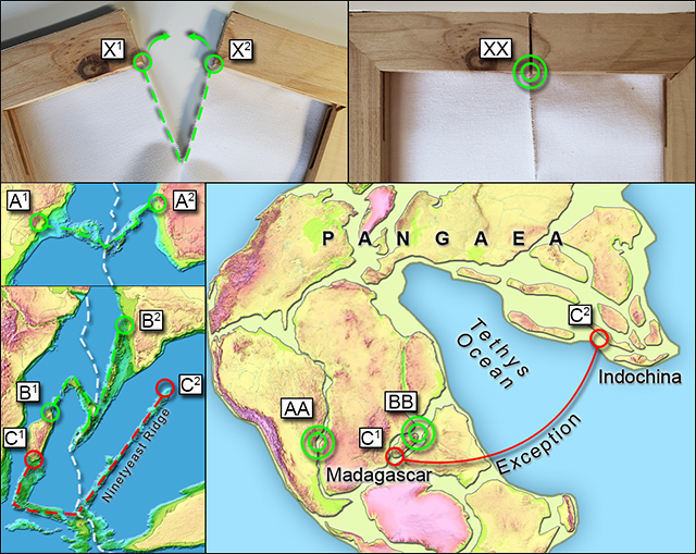
Figure 9 – Due to plate tectonics’ bold shoehorning in of a hypothetical, nonextant Tethys Ocean, one of these pairs is definitely not like the others. Elimination of the Tethys Ocean connects all the dots by reconnecting Southern Madagascar(C1) with Indochina (C2) at the time of Pangaea, but at the expense of a static Earth.
(Lower left: Modified images from the USGS)
The simple fact is that coastal ductile fractures exist throughout the globe, and we continue to overlook them along with the fact that they and even brittle fractures, like Madagascar, consistently exhibit alignments with seafloor ridge formations. At some point, researchers will have to acknowledge this undeniably obvious relationship between continental fractures and seafloor ridges and subsequently resign themselves to the very real possibility that seafloor ridges are not generated by invisible hotspots deep within Earth’s mantle but are merely instances of fracture propagation.
And these are not the only ridges that require a reevaluation. Plate tectonics adds to its current level of inconsistency by proposing a second method of seafloor ridge creation. This alternate dynamic comes into play when describing ridges known as island arcs. These linear ridges are currently believed to be formed as subducting seafloor plates generate friction which heats magma to such extreme temperatures that it melts through the overriding plate generating a linear array of volcanic islands.
Overlooked is the fact that the patterns associated with these island arcs can once again be attributed to fracture dynamics, thus achieving a global consistency for seafloor ridge formations that plate tectonics lacks. Fig. 10 takes us back to the canvas frame once more to demonstrate how the V-wedge occurs when a wooden frame becomes fractured and splinters. The overall formation occurs as the fragment remains anchored to the canvas while the rest of the frame rips itself free and is pulled away from the canvas. Fig. 10 highlights this shared formation where Kamchatka represents the splinter and Asia represents the main portion of the frame that has broken free and moved away from the Pacific seafloor plate. And once again, the V-wedge continues to conform to fracture propagation as the upper two points of the wedge dictate where two continental plates separated and how they would join back together before fracturing.
An interesting aspect of the current back-arc spreading theory is the belief that these island arcs should occur anywhere along a continental plate where subduction is occurring, but researchers do not take into account that each of these island arcs extends directly from a continental fragment. The Kuril-Kamchatka island arc, for instance, is aligned directly along the outer edge of Kamchatka. Other instances of fragments or peninsulas aligned with island arcs include Japan, Korea, Alaska, the Yucatan, and Palmer. This appears to confirm that every major seafloor ridge whose origins are currently attributed to either back-arc spreading or hotspots is aligned with a fracture point.
This sets out a significant pattern of global consistency among seafloor ridges that science currently does not recognize, and it is a pattern that rises far beyond random occurrence. Lacking this awareness, plate tectonics continues to assign inconsistent dynamics to seafloor ridge creation—super-heated hotspots and subduction-generated friction—whereas fracture dynamics predict these alignments because the ridges are a repeatable form of fracture propagation.
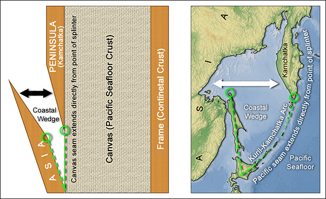
Figure 10 – Similar to purported hotspot ridges, island-arc ridges consistently extend from fracture points and mimic patterns of fracture propagation.
(Right: modified image from the USGS)
Conclusion
Much of what we recognize as the foundation of plate tectonics was cobbled together in the 1960s, and it was a well-reasoned theory within the limits of available information. Many considered it to be a unified view of Earth’s past that gradually put to rest any serious scientific pursuit of Earth expansion. John Tuzo Wilson, an ardent supporter of Earth expansion in 1960, would eventually abandon the Earth expansion model and by 1963 propose the existence of unseen subterranean forces as the source of linear seafloor ridges like the Hawaiian-Emperor seamount chain. These would later come to be known as hotspots. It was an unfortunate bit of irony that would see the one-time Earth expansionist making his mark on plate tectonics history with a shortsighted misinterpretation of evidence that ultimately supported Earth expansion.
In ancient times it was common practice to credit unseen forces or entities with the creation of complex geological structures, only to see these beliefs discredited and abandoned later as it came to light that the structures mimicked formations that could be replicated through natural processes. For several decades now, attributing seafloor ridge formations to unseen forces deep within the earth seemed a sensible and plausible option, but now that it has finally come to light that these unseen insentient forces are consistently mimicking the natural repeatable patterns of fracture propagation, perhaps we should seriously consider whether it is time to abandon the unseen, embrace the immediately obvious, and finally put a sixty-year-old dragon to rest. Unfortunately, what had the potential to be a brief head-slap moment had it been presented early enough to John Tuzo Wilson 60 years ago and should be found curiously obvious to engineers and material properties experts today will likely prove difficult for Earth scientists to accept and support while peering through a haze of research stacked just a few decades deep or while weighing risks to reputation and career.
Ultimately, however, when we see hoofprints, we should think horses, not zebras, but by the year 1960, when we were certain that our planet’s surface was composed of fractured plates and we should have continued thinking fractures, we were already thinking zebras. No one happened to notice the many ductile coastal fractures that litter our planet, and no one considered fracture propagation when studying the seafloor ridges that perfectly aligned to both ductile and brittle continental fracture points. Instead, we postulated exotic theories of seafloor ridges formed by hotspots and island arcs formed by friction-generated mini-hotspots.
The disparity in observational clarity and consistency that separates the hotspot and fracture propagation theories is so vast and conspicuous that it leaves little doubt as to which is the horse and which is the zebra. While not necessarily eliminating the hotspot theory, how scientifically negligent—and glaringly ironic—would it be to continue crediting these exotic unseen forces with leaving behind hoofprints on the seafloor while completely ignoring and refusing to address the horses—in the form of continental fracture points—consistently found standing immediately at the end of those hoofprints? Fracture propagation may not have the exotic appeal of the theory currently favored by researchers, but how long can we continue maneuvering around the horses standing directly in the hoofprints because we choose to pin all our hopes and wishes on an elusive unseen zebra? If only wishes were horses…
Giddyap.
(A more in-depth article addressing ductile fractures and ridge alignments can be found here.)
References
1 Strabo, Strabo’s Geographica 2.3.6, translation by H.C. Hamilton, Esq., W. Falconer, M.A., Ed.
2 Sagan, Carl. (1997), The Demon-Haunted World: Science as a Candle in the Dark. Random House Publishing Group
3 Dietz, R.S., and Barringer, J.P. (1973). Hudson Bay Arc as an Astrobleme: A Negative Search. Meteoritics, NASA Astrophysics Data System, p. 28–29
4 Logan, Andrew (2000). The Ring of Fire. www.pbs.org
5 Shapiro, M.N., Soloviev, A.V., and Ledneva, G.V. (2006). Is there any relation between the Hawaiian-Emperor seamount chain bend at 43 Ma and the evolution of the Kamchatka continental margin?, mantleplumes.org
6 [email protected] (1999), J. Tuzo Wilson: Discovering Transforms and Hotspots, pubs.usgs.gov
7 wikipedia.org. Zebra (medicine), www.wikipedia.org
Hi Doug
You will be pleased to know that I have ordered your book, sounds fascinating.
I just wanted to share with you a thought I have held for a number of years. I think that the Eastern line of the Andes more closely matches the western coast of Africa, the countries of Panama, Nicaragua and Guatemala would wrap nicely around the North of Africa, and that Spain would sit nicely in the gulf of Mexico. That would mean that Brazil and other east coast countries of South America would have emerged from beneath Africa.
Probably a silly idea but ot has always been a curiosity to me. Anyway, you are a maps guys so I thought it may be interesting.
Kind regards
Shane.
Thanks, Shane.
Sorry. I had forgotten about the comments section here. 🙁
Not necessarily silly. This is where Wegener and others including myself started. You may find it interesting how I addressed Panama, the Yucatan Peninsula, and Honduras. Plate tectonics puts way too much emphasis on the chaos of plate movements and collisions and sometimes simple patterns of fracture and separation are overlooked.
Thanks so much for buying my book. I hope you find it an enjoyable and insightful read.
Hi Doug
Thank you for getting back me, your book has arrived and I am steaming through it 😃
Kind regards
Glad to hear it, Shane.
Feel free to share any thoughts or questions that might arise. You are also welcome to contact me directly via my linked website, copheetheory.com, at the top of this page.
What I wonder is, by what effect should a sphere increase its volume? In case of Earth, this requires quite a lot of work against gravity! Your concept asks for an energetic miracle! The most competent that I found on the subject is: https://lah.ru/geoscale-text/ The site is in Russian, but a Google translation is good enough for understanding. According to this, the decay of metal hydrides drives the expansion. Interestingly, this thesis also provides an explanation for the abiotic deposits of coal, oil and natural gas.
Incidentally, I believe that the capture of the Moon reshaped the Earth geologically and geographically: https://grahamhancock.com/eilinga2/
Maybe, an alternative to your theory.
Hello Aloys,
Thank you for the info and links. Andrey Sklyarov’s article is very intriguing as is yours. I skimmed through both a bit and will have to go back later to take it all in. As I stated in the forum and Andrey states in his article, plate tectonics has had 60 years and the full force of the scientific community but just a handful of gifted individuals are attempting to work out expansion and coming up with some intriguing concepts. It’s impressive and makes one wonder what research and theories would arise if we turned the tide and consensus fell on Earth expansion.
Regarding your moon theory, it is intriguing. The moon’s impact on Earth is remarkable, and I too am not entirely sold on the moon/Earth impact theory.
Also, I don’t directly address submarine canyons as you do in your article, but they have been considered and within the scope of my findings. No one seems to have noticed that riverways often align directly with the center of a ductile coastal fracture confirming that water did not cut the path through the surface, but brittle fracturing extending inland created trenches that waters would naturally drop into and flow out through. Meanwhile, fracture propagation would extend out onto the seafloor creating canyons in some instances and ridges elsewhere where upwelling magma was able to break through. Other instances where coastal ductile fracture are not apparent, riverways are flowing through brittle fractures that have not experienced ductile fracturing along the coast.
Thanks again for the links. Very much appreciated.
I just ordered your book, also. This is going to be fun. As far as “hot spots” are concerned, how would you fit the Yellowstone “hotspots” moving the west through the Snake River watershed….its Friday, got time on my hand and wandering through Graham’s website. Always interesting…..
Hello David,
I (and I’m sure Graham) thank you for stopping in.
Thanks for ordering my book. I share your curiosity about the Yellowstone Caldera. It is a truly intriguing geological feature that I looked at extensively, have some thoughts, but did not feel strongly enough to include them in my book. I hope you enjoy the read despite the spoiler.
Some years ago a mantle plume was discovered under South America by researchers at Brown University if I recall correctly. This also refutes plate tectonics.
Thanks, Charles. I would love to see a link to the discovery. Sounds interesting.
Hello David,
I (and I’m sure Graham) thank you for stopping in.
Thanks for ordering my book. I share your curiosity about the Yellowstone Caldera. It is a truly intriguing geological feature that I looked at extensively, have some thoughts, but did not feel strongly enough to include them in my book. I hope you enjoy the read despite the spoiler.
need to reach Mr. Fisher; he left a book at our store so we could review for a meet ‘n greet and I don’t seem to find any contact info for him. If you could pass my info along; we would like to chat about a signing event. We are Copper Cat Books, 1750 West Horizon Ridge Parkway Suite 170 / Henderson NV 89012 (702) 567-2666 / http://www.coppercatbooks.com