


This piece is written by William Glyn-Jones, and like his previous posts here on the Forum page, it is drawn from material in his book Amazement Arcadia, for which he is seeking publication.
It is not without a little embarrassment that I confess to the source of the initial curiosity that lead to the theory outlined here. When it was suggested to me that a novel called The Da Vinci Code might be my kind of thing, I turned my nose up in indignation and disgust. For a start, not being sold on the dogmas of Christianity and the historicity of that whole Jesus thing anyway, the concept of something that might "shake the very foundations of Christianity" produced in me little more than a yawn. What firm foundations were they, remind me? Besides, just a look at the book's cover blurb was enough to show me that it clearly wasn't my kind of read. The thing is a thriller, starting with a brutal murder, for goodness sake, a clear example of an author resorting to dark and base devices to get people hooked into something, like a fish hooked painfully on the end of a line, the barbed hook viciously gouging through its cheek.
So how come I ended up reading it? It's like this. I found myself in a Paris station about to board a train that would take me on a long, long journey down to the South of France. I didn't have any reading matter, and the selection of English language books on the shelf of the station's bookshop was not enormous. Even that hook through my check might be preferable to the boredom of twiddling my thumbs for several hours. Besides, I was in Paris. Wasn't the whole thing at least somehow rather appropriate? So, yes, I bought it, and began turning those pages.
And ok, I admit it: I couldn't put the flippin' thing down. And the following morning, with the thing finished at last, there I was lying on a bed (in a house in Provence) wondering… thinking… pondering….
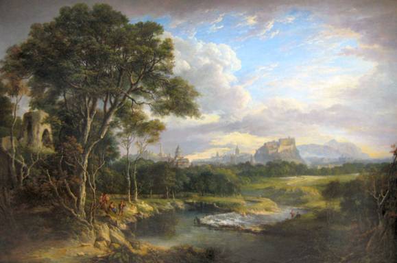
I'll tell you what it was that had got a hold of my curiosity. The Last Supper business was already familiar to me from reading The Templar Revelation, and likewise the Jesus bloodline thing was not too interesting to me as I was already familiar with Holy Blood : Holy Grail. Something else captured my mind. In his fictional story Brown identifies two Grail locations, and in both cases he links them to a) a meridian or north-south line, and b) the symbolism of the male "sword" intersecting with the female "chalice", namely the two interlocking equilateral triangles of the hexagram, also called the Seal of Solomon and the Star of David. These two locations were of course Paris, France, and Roslin, Scotland. In both these cases these were themes that Brown borrowed from other writers. For example, Robert Bauval had previously suggested in The Secret Chamber that this combination of pyramid and inverted pyramid at the entrance to the Louvre, Paris might be a reference to the esoteric pattern known as the Seal of Solomon of the interlocking triangle and inverted triangle, that is to say the hexagram, and Lomas and Knight in the Hiram Key connected Roslin to the (Herodian) Temple of Jerusalem and the traditionally connected Seal of Solomon geometry. For Dan Brown the inverted pyramid is like a feminine chalice, the pyramidon on the floor below it being the corresponding male symbol of the blade.

In The Da Vinci Code the final clue relates this pattern to the location of the Grail:-
The Holy Grail 'neath ancient Roslin waits.
The blade and chalice guarding o'er her gates.
Adorned in masters' loving art, She lies.
She rests at last beneath the starry skies.
The reader is asked to consider that though this appears to be about the site of Roslin in Scotland, in fact it refers to the glass pyramid at the entrance to the Louvre. "Roslin" becomes reinterpreted by the novel's protagonist sleuth not as the place in Scotland but as the "Rose Line", i.e. the Paris Meridian; the "masters' art" becomes not the elaborate stonework of Roslin chapel but the works of the Old Masters in the Louvre gallery; the "starry skies" refer not to the stars on the ceiling of Roslin chapel but to the night sky seen through the glass of the Louvre Pyramid, and the "blade" and "chalice" become not some Seal of Solomon pattern supposedly formed by the floor plan of Roslin Chapel, but the Louvre Pyramid and La Pyramid Inversée. Such is the climax of the world's best-selling novel.

I do have a romantic side, and the way I deal with it sometimes is to agree to follow through on its curiosities, if time and situation allow, and then if, and only if, they lead somewhere interesting, so much the better, (and sometimes it comes up with the goods) but if not, I let the matter go. In this case, my romantic side was saying "What if…what if…what if there is more to this than meets the eye? There may not be, but I'm on holiday, with time to spare…I might as well just check it out, nothing to lose." Why does Brown introduce the meridians, but then have them play basically no other function other than as part of a treasure map? (One of the things he got correct in the novel is that the Paris Meridian passes directly through the Louvre site.) The hexagram is a geometric figure, and so is a meridian – it being a straight line – so are there not further questions to be asked about the connection between this pattern of the two triangles and the two meridian lines?
This is what I pondered. What is the relationship between the Seal of Solomon and the meridian that runs across the map of France?
And then a thought occurred to me.
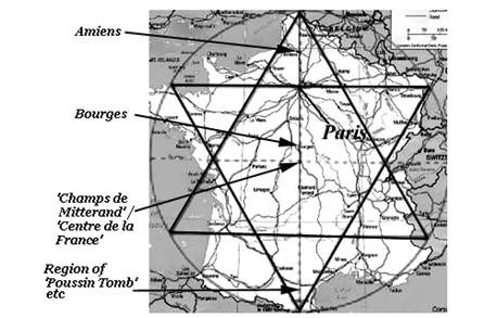
The shape of France on the map is hexagonal.
L'hexagone is actually used by the French as a nickname for their country. I even seemed to recall that there was a French national newspaper that took this as its name, for this reason. It was time to get hold of a map of France. How did the Paris Meridian relate to the hexagonal shape of France?
I soon found a map, and then noted something very interesting. Effectively, the Meridian runs from the North Point of France down to the South Point, and I could also see that the line bisected the nation vertically into what looked like two fairly equal halves. In other words, the Paris Meridian runs from the top tip of the first equilateral triangle of the hexagram down to the bottom tip of the other triangle, the inverted one. I thought again of this business of the intersection of Blade and Chalice. The Chalice is the inverted triangle, and I found myself wondering where the meridian bisects this. Looking at the map it occurred to me that this might actually be at Paris. If so, Paris would be at ¾ of the way along the Meridian line measuring from South Point up to North Point. Well, that wouldn't be a difficult measurement. I'd just need to measure the length of the full Meridian on the map, multiply by 0.75, and then measure that far up, and see if this pinpointed Paris. I only needed a ruler and a calculator, and I had soon laid my hands on this equipment.
When I made the required measurement I found that yes, ¾ of the way up the line does indeed pinpoint a spot smack bang in the heart of Paris. In other words, the Louvre pyramids and their little brother on the floor below are indeed located at the intersection of the Blade and the Chalice, if the Blade is taken at the Paris Meridian (more on this in a minute), and the Chalice as the inverted triangle formed from the hexagram placed onto the map of France.
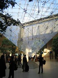
This much I worked out that morning, and resolved that on my return journey I would join the Da Vinci Code tourists and have a look at the Glass Pyramids outside the Louvre before I got on the train that would pass through the tunnel and bring me back to Blighty. Of course there was more research to be done here, but that could wait 'till I got home. So, as planned, I paid a flying visit to the pyramids as I stopped in Paris on my way back, and sure enough there were the Dan Brown fans with their cameras. Did they believe the "Holy Grail" was buried under there, and/or the bones of Jesus' wife Mary Magdalene? I didn't believe that, but I was by now starting to wonder if there was more to this mystery than immediately met the eye.
One of the most obvious next questions to ask was that of how the site of Roslin in Scotland came into all this. Brown introduces again the concept of a Rose-Line and then he tells us this line if extended further south goes through Glastonbury. I checked this out and soon discovered it to be nonsense. It doesn't go anywhere near. It does of course go north through the Scottish capital of Edinburgh, and I also noticed that, as with France, it goes to a point on the north coast that could certainly have been regarded as the effective North Point of Scotland. Since Roslin is also connected by Brown with the Seal of Solomon pattern, (following, or rather loosely inspired by Lomas and Knight in The Hiram Key) it was perfectly obvious what I had to do. So I measured the ratio, and found with some surprise that yes, Roslin is exactly ¾ of the way along this Scottish "Rose Line", this time measured from the North Point down to the southernmost point on this longitude line, where it meets the sea at the Solway.

In fact the longitude of Roslin, 3°9'36.72" West (of Greenwich), runs directly up through Arthur's Seat in Holy Rood Park in the centre of Edinburgh, as can be seen using the Google Earth gridline feature. This notable landmark, Arthur's Seat, which dominates the city, is the highest of a set of peaks that form the image of a crouched lion, which is why the hill is also known as the Lion's Head. The name Arthur's Seat may indicate an old association with King Arthur. (An early Welsh poem recorded in the 14th century, which mentions Arthur, describes the heroes feasting for a year at Edinburgh.) With this being the highest of Edinburgh's seven peaks, one could understand the logic of the Meridian being made to pass through it, as the plotting out of the line would have required the sighting of distant landmarks.
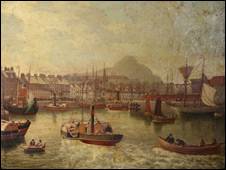
Arthur's Seat seen from Edinburgh's port of Leith
And just as Paris had a royal observatory from which the French national meridian was plotted out, and as the Global Prime Meridian goes through the royal observatory in Greenwich, there is also a royal observatory in Edinburgh, which originally stood on Calton Hill. Brian Hooker notes in his essay A Multitude of Prime Meridians on the Internet that from the start of the 1700's it was quite common for countries to select the longitude of their national observatory as their zero meridian (and visa versa?). The history of the Edinburgh observatory can be traced back through the first lectures in Astronomy at the Edinburgh University in 1583 through to the establishment of a Chair of Astronomy there in 1786, and the Calton Hill observatory was granted royal observatory status in 1822 by George IV of Britain, who, we may note in passing, had been the Grand Master of the Masonic Grand Lodge of Scotland since 1805. The building used at that time had been designed by the classical Greek revivalist architect William Playfair – and it looks more like (and indeed is based on the design of) a classical temple than an observatory. One Scottish Astronomer Royal based here was the clever but loopy Piazzi Smythe, whose book on the Great Pyramid includes a diagram showing how a meridian through that ancient monument divides the Nile Delta in half and meets the coast near the northern most part of the Delta arc.
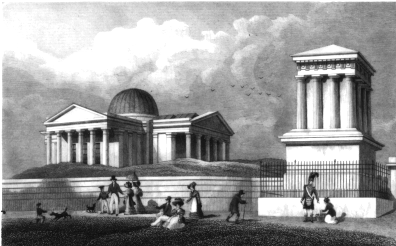
Above: Playfair's Edinburgh Observatory
The above painting by Alexander Nasmyth, painted in the year the observatory was granted royal status, shows the observatory in the centre, with Arthur's Seat rising in the distance on the far right, beyond the castle.
I think it was at this point that I really started to consider that the whole business had gone beyond what could be put down to chance. It was time to have a look at what was known about the history of Roslin, and to see if there were connections to Paris, and also to see how the concept of a meridian might have been of significance to its builders. I decided in addition that I wouldn't be much of a researcher if I didn't also look into whether the technical knowledge was available to whoever might have been responsible for plotting out this scheme, and to consider whether the Paris Meridian might have been older than its official inauguration by Louis the Sun King (given that Roslin is considerably earlier), and then there was the question of how the much more recently built Louvre pyramids could be related to the symbolism of the geodetic scheme, and for that matter I wanted know as well where this "blade" and "chalice" symbolism arose from.
First things first. I discovered that there were in fact many historical connections between Roslin and the French court in Paris. Roslin Chapel was founded by Sir William St Clair in 1446. This Sir William had in fact travelled himself to the royal court – located in the palace at the Louvre site in Paris – as ambassador and escort to the Scots Princess Margaret, who went on to marry the Dauphin (i.e. the heir to the French throne.) When he returned from France the earl set about a major building programme that included remodelling Roslin Castle in the French style. In addition, Sir William's friend and tutor was Sir Gilbert Hay, a top scholar of the time who, after leaving St Andrew's University in Scotland, went to France and lived in the royal court in Paris for twenty years, becoming the chamberlain of the future French king. When he returned to Scotland he lived at Roslin under the patronage of Sir William, and it was while he was living there that Roslin Chapel was built. These facts are given in the work of the Scottish historians Oxbrow and Robertson, Roslin and the Grail, which, despite the sound of its title, is based on historical documents rather than speculation, and makes no great sensationalist claims.
Exactly a century later, in 1546, queen Mary of Guise, consort of James V of Scotland, after visiting Roslin Chapel south of Edinburgh, wrote to its owner, another Sir William St Clair mentioning a secret that he had shown to her and promising not to reveal it. Sensing some great mystery, many have speculated about what it is that Roslin guards. Mary of Guise was herself of royal French stock, and while she was ruling as the regent of Scotland, the Florence-born Medici queen Catherine was made regent in France, ruling of course from the chief palace at the Louvre, where she had the builders start work on the Denon wing in 1560, the part that now houses works by Da Vinci and Michelangelo. At times during these periods Scotland and France were allies, and indeed Mary of Guise' daughter married one of the sons of Catherine de Medici.
So much for connections between Roslin and Paris. What about the significance that a meridian line may have had for those who plotted out this line? William St Clair was a patron of men of letters, and he was plugged into the network that connected to the new humanism of the Italian Renaissance that was emerging at this time. As early as 1438 the Greek scholar Plethon was lecturing to the Florentines about Neoplatonic philosophy, and it was the likes of Plethon who introduced the Medici circle to a group of texts which Cosimo Medici then had Marsilio Ficino translate from the Greek. These included the works of the ancient Neoplatonic philosopher Porphyry, who wrote an intriguing essay entitled the Cave of the Nymphs, in which a meridian line extending to the south is described as the journey taken by the enlightened Soul when passing on back to the Realm of the Immortals. Porphyry himself had developed this idea from the Platonic dialogue called Phaedrus in which we are told that due south, where the Zodiac constellations culminate at the top of their arc, is a portal to the realm of universal, intelligible Ideas, of eternal Forms and the immortal gods. Virgil in one of his eclogues describes the ideal shepherd Daphnis ascending to this portal of the sky during his apotheosis, an event which resulted in the greening of nature, which had mourned his death. Since the ideal shepherd constellation is Bootes, and Bootes rides to his highest point due south in summer, it seems that it was this astral event to which Virgil's poem refers.
Although this may seem like a tangent from our theme, I am introducing it now because it turns out a little later to be something which sheds a great deal of light on this whole business. Whilst Daphnis was a Sicilian name for this ideal herdsman figure/constellation, the Athenian name was Ikarios, who was a figure explicitly connected with the Bootes constellation by Hyginus, following Eratosthenes, the same Eratosthenes who is the first geographer we have known (from references in other writers) to have worked with the idea of a longitude meridian, this one going through Egyptian Alexandrian. Eratosthenes was chief librarian at Alexandria, and he wrote a work on the mythic figures connected with the constellations, this work being the chief influence on the Roman Hyginus' work Poetic Astronomy, where we are told Ikarios is Bootes. The multitalented Eratosthenes also wrote a poem about the Ikarios story, for this figure was the shepherd who was the first man to receive the gift of wine from Dionysos. In Greek myth the island of Ceos suffered a plague because it was harbouring the killers of Ikarios, and only when a tomb/shrine was built for him, and the killers brought to justice, was the island regenerated. This is the source of Virgil's eclogue, where likewise a tomb is built to honour Daphnis, and the regeneration of the land, which had been mourning him, results. This in turn associates the apotheosis of Ikarios/Daphnis/Bootes with the return of the Golden Age, for it was said that at the end of the Golden Age the goddess Justice (Astraea) fled up into the skies, where she became the Virgo constellation, her scales becoming the adjacent Libra constellation. More on this in a moment.
So the significance of the Meridian for the founders may have been derived from the Neoplatonic concept of the portal of the sky due south, but how, I wondered, might this have been seen as related to the hexagram pattern?
In The Republic Plato uses another simile to explain this philosophy of the Realm of the Eternal. In this simile, known as The Divided Line, he describes the journey from the realm of purely subjective perception towards that of mental resonance with these eternal ideas as being like a line, and he explains the spectrum between the two by dividing the line into four zones. So at one end there are the shadows of illusory projections, then in the second zone are beliefs, in other words received wisdom that you have not examined yourself, but simply accepted because you were told that it was so. The third zone Plato describes as being that of Reason. Here critical reasoning is used to arrive at ideas that have an objectivity. Then the fourth zone goes beyond this by partaking of a more direct fusion with realm of universal ideas. No matter how well a student is taught, he may simply lack the inborn Soul-wisdom to perceive ideas at this more visionary level, for it is somehow a memory of the immortal realm experienced by the Soul before incarnation.
In the geodesic scheme we appear to have uncovered in France, as replicated in Scotland, what we have at the most basic level is the line, running north to south, divided into quarters. If one wants to use geometry to divide a line into four zones, as in Plato's simile, then the Seal of Solomon, or hexagram, is in fact one of the easiest ways to do this. But is it feasible that the Renaissance humanists of the 1400's were working with such ideas?
Actually, yes, for The Divided Line became a major influence on the model used by the Florentine Platonic Academy. Cosimo Medici attended the lectures of Plethon, mentioned above, and then when the lectures came to an end he was so enthused that he decided to set up a new Platonic Academy like the one Plato had formed. Marsilio Ficino became the head of this academy, and in Ficino's scheme there were various kinds of love, each corresponding to a human faculty. So there was Amor Ferinus, the base animal drive of the world of the senses, then the Amor Humanus, corresponding to the realm of human faculties such as Reason, and then there was the Amor Divinus, corresponding to Plato's fourth zone of fusion with the realm of universal ideas. To quote Panofsky in his book Studies in Iconology : Humanistic Themes in the Art of the Renaissance, the Florentine Neoplatonists such a Ficino saw this upper zone of Mind as something that "can grasp the truth by directly contemplating the supercelestial ideas," for "where Reason is discursive and reflective the Mind is intuitive and creative" and it "communicates with, or even participates in, the intellectus divines" and "sees with an incorporeal eye".
Clearly, then, these guys were fully conversant with Platonic similes such as The Divided Line.
But then I reactivated my own human faculty of Reason. I knew that we were talking about geodetic schemes that must have been fully planned out by the time that Roslin Chapel was built in 1446. True, the Platonic Academy was busy forming at this time in Florence, but could it really have extended its influence across France and Scotland so quickly? And how well did this Neoplatonic context fit with an iconological examination of the carvings that we actually see inside Roslin Chapel?
While I was contemplating these matters I suddenly felt a nagging sense of déjà vu regarding the notion of the Paris Meridian as a "blade". Wasn't there an image in the book Holy Blood / Holy Grail that depicted something along those lines? Leafing through my copy I found the image, taken from the cover of Circuit, a small magazine brought out in the 1950's by the man who claimed to be the secretary of the group calling itself the Priory of Sion, namely Pierre Plantard. In Plantard's image, which predates The Da Vinci Code by half a century, the blade of a sword runs along the Zero Meridian, and the image even has the hexagram placed over the French map!
So this image comes very close to pre-empting the scheme I believed myself to have uncovered, but it managed to obfuscate the revelation by distorting the relationship between the hexagram and the meridian. In Plantard's image the bottom of the hexagram is exactly on the southern border, but, presumably so as not to give the secret away too easily, he has not made the top of the hexagram map onto the north point, thus hiding the fact that Paris is at the intersection point.
The Priory of Sion documents make various leading mentions of lost tribes of Israel, fitting the Seal of Solomon into a Jewish context, and relating these matters to Jerusalem. So I was intrigued to find, when reading up on the Solomon episodes in the Bible, various references to just such a sword. In the book of Chronicles in the Bible we read how David sent out men to 'number Israel', and then 'David looked up and saw the angel of the LORD standing between Earth and Heaven, and in his hand a drawn sword stretched out over Jerusalem.' David asks what should be done to rectify things, and he is commanded to go to a particular place to build an altar. He is inspired to build a great temple, but is told that because he was a man of war he may not do so, but that his son will be a man of peace, and it will be he who builds the temple. This son is of course Solomon. (The name even includes 'Salem' – 'Peace'.) 'And David commanded to gather together the strangers that were in the land of Israel; and he set masons to hew wrought stones to build the house of God… So David prepared abundantly before his death. Then he called for Solomon his son, and charged him to build an house for the LORD God of Israel. David also commanded all the princes of Israel to help Solomon his son, saying…arise therefore, and build ye the sanctuary of the LORD God, to bring the ark of the covenant of the LORD, and the holy vessels of God, into the house that is to be built to the name of the LORD.' Then in the next part of Chronicles Solomon begins the work of creating this temple, and it is a part of the Bible that has been important for Freemasons, for it is here that Solomon enlists the help of King Hiram of Tyre. According to a strand of Masonic tradition Hiram's craftsmen were the Dionysiac Artificers who had come from Bronze Age Greece, and they were the proto-Freemasons.
In Chronicles we read that 'Solomon determined to build an house for the name of the LORD, and an house for his kingdom.' Notice that the temple is to be built 'for the name of the Lord'. Legend says that Solomon had a gold ring with the name of god on it which brought good luck and warded off evil, and this same ring is also behind the name 'Seal of Solomon', for it was said that the hexagram was the symbol upon it. If the 'name of the lord' and the hexagram are one and the same, and the temple of Salem was built for this 'name', we could say that the French hexagram was intended to be just such a talisman. In the Bible the sword that stretched across Jerusalem represented God's wrath towards David because of his transgressions, while the temple David told Solomon to build at a special place was definitely intended to appease this wrath – just building it would bring health, peace and plenty in the kingdom.
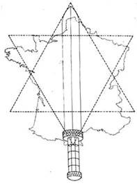
It seemed to me that if 1446 was just a little too soon for full-on Neoplatonism to have been so fully manifest way off in Scotland, then here with these Biblical traditions we did at least have a context appropriate to the pre-Renaissance mentality. When the historians Oxbrow and Robertson examined the iconography of Roslin Chapel in the research for their book Roslin and the Grail what they found was a catalogue of references not so much to the old Jerusalem of Solomon, but to the last book of the Bible, that of Revelations. The Sinclairs, it seems, imagined themselves rising from their graves in the crypt below the chapel on the 'day of judgment'. In Revelations the old world passes away, but a New Jerusalem appears. The dimensions given for this in Revelations are interesting. Not only is it as broad as it is long, but the same distance is also given for the height. Therefore, the New Jerusalem appears to be in the shape of a cube. It is one of the interesting features of the hexagram, extended to form the hexagon, that it forms the image in 2D of a 3D cube (albeit without perspective), and the cube – one of the Platonic Solids – is in fact a much-repeated motif in the stonework of Roslin chapel – there are 213 in all.


The Hexagon Viewed as a Cube and right, a few of the many Roslin cubes
My romantic self could not help but wonder, therefore, if the geodesic plan of France, the meridian and the hexagon, duplicated in Scotland, was intended to be the establishment of the New Jerusalem on Earth. I then started to think about the Templars, who called themselves the Knights of the Temple of Solomon, and of their cathedral-building activities, and wondered if this plan went back to those mysterious figures. After all, the construction of the Louvre in its earliest form was initiated by Phillip II, of the House of Capet, when he ascended the throne in 1180. At this time the Templars had been going strong for a century, and their order would not be suppressed until a century later. This same king actually went on a crusade to the "Holy Land" with Richard the Lion Heart. Had the enthusiasm for the Seal of Solomon – the Hexagram – been picked up from Arab legends during these times? Phillip, judged a good king by his people, became ill and lost his zeal for the crusade and returned home. So much for the Old Jerusalem, why not build the New Jerusalem somewhere closer to home, in a place we don't have to fight for, he may have thought.
There is in fact an intriguing link between the Jerusalem site – the location of the Temple of Solomon, whether First, Second or Third – and the Seal of Solomon, via a natural feature of the latitude and an element of Freemasonic tradition. The Freemasonic writers Lomas and Knight in Uriel's Machine relate an intriguing piece of Freemasonic lore: a Solomon Rectangle is one produced by aligning from a particular point to the Winter and Summer Solstice sunrises. The point then becomes the centre of the rectangle, and the extended alignments to these points become the diagonals of the rectangle. The alignments can be found by observing shadows cast by posts. Such a function then becomes attributed to the twin pillars said to stand at the front of the Temple of Solomon, Jachin and Boaz. At the latitude of Jerusalem the Sun can be observed rising at 30 degrees north and south of due east on the two solstices. This makes the Solomon Rectangle at this latitude the Square Root of Three rectangle that is formed by the Seal of Solomon pattern.

And the outer ground-plan of Rosslyn Chapel, including the buttresses, does in fact conform to this pattern.
There is also, within the Freemasonic Third Degree initiation, an element of the rite which connects the Temple of Solomon with a north-south meridian. A certain Hiram Abif is struck at around noon by a man standing at the south gate with a plumb bob in his hand. I want to suggest a new interpretation of this. In Ancient Egyptian Thebes, the Sun-god Amun-Ra destroyed the darkness-serpent Apoph at noon, the strong-time of the Sun. (The Sun-god Apollo repeated this at Delphi, according to legend, slaying the serpent Typhon.) I want to put forward the proposition that "Abif" = "Apoph". "Hiram" simply meant "king". Whether or not this is correct, there can be little doubt that a man standing due south holding a plumb bob was engaged in plotting out the North-South line, the Meridian, to align the temple. So the solar connections give us, through Masonic tradition, connections between the Temple of Solomon and both the hexagram and the meridian. One might even imagine the "Sol-" of "Solomon" pertaining to the Sun, if he wasn't a Semitic figure.
These intriguing realizations could easily have set me off down a Templar = Rosslyn = Freemason = Egyptian course, at which point I realised my romantic self was threatening to put me in a position where my head was on the scholar's chopping block, Dan Brown style, so I pulled back on the reigns, out of self-preserving interests, if nothing else. Besides, the Sinclairs testified against the Templars, so I'd be more inclined to look to royalist roots, given the general flow of things. There was a temptation to engage in wild speculation without much actual fact to go on. History spread before me a tangled web of names and dates, and then I realised, or remembered, that Reason alone wouldn't get me where I wanted to go. It was time to move to that fourth zone, that of intellectus divines as the Florentine NeoPlatonists called it, and to perceive the whole with the "incorporeal eye" as a "supercelestial idea" rather than just some unsolved historical puzzle. To put it another way, the value in all this, it seems to me, is in the basic establishment of a harmonious geometric plan as the foundation for a nation. It uplifts the sense of place, infusing the idea of a nation with a certain essence of harmony and order.
But my Reason still had a question or two it wanted answered. Is it feasible from the technical point of view that as early as 1446 Europeans were not only plotting out straight north-south meridian lines, but that they were also able to measure latitude so as to divide these lines up into ratios and regular divisions?
I soon discovered that not only was the technology available then, but in fact it had been for some time. Unlike a geocentric Universe, a flat Earth was never, in fact, a Christian dogma. Although there were one or two Christian writers that didn't believe in the globe, Classical Antiquity did in fact bequeath this knowledge to the Dark Ages of early Christianity. The Greeks had worked out that we live on a globe, and from at least the time of Eratosthenes around 235 BC even the rough size was known from calculations based on shadow lengths at different latitudes in southern and northern Egypt. Phineas, a philosopher resident in the Greek colony of Marseilles in the South of France, travelled up from there through the British Isles taking latitude measurements along the way, and the figures quoted show he went to the north of Scotland. In the second century BC the Greek philosopher Hipparchus had been working with a system where the Earth was divided up into lines of longitude and latitude; by Claudius Ptolemy's time longitude was measured with respect to a Zero Meridian through the Canary Islands (a line running due North-South), and Ptolemy had even used projection formulas to transfer the map from the curved surface of the globe to a flat representation. No-one seemed to be writing about longitude or latitude during the Dark Ages, but by the turn of the eighth century the Venerable Bede certainly had no doubts that the Earth was spherical. Then by Chaucer's time in the Early Renaissance (in the 14th century) the ancient method for calculating latitude by use of an astrolabe to guage solar or stellar inclination angles was certainly known, for Chaucer actually wrote a poem about it. This is knowledge that allows one not only to plot out a north-south meridian line, but also to divide it up into particular ratios, based on relative latitudes.
It was a chancellor of Chartres Cathedral in France, Fulbert, who was, according to historian George Henderson in his book Chartres, the first man in Europe known to have used the astrolabe, an instrument that finds positions and altitudes of the stars, which he did from the top of one of the towers of the cathedral. Fulbert's period was in the early eleventh century. Chartres' statues include seven women representing the Liberal Arts and for each art there is also a statue of an ancient expert in that field, including one of Ptolemy, and since they were reading Ptolemy they must have come across the notion of longitude measured from a meridian.
In the late Dark Ages the classical writers were still being studied at the School of Chartres, in Northern France, around the time that Hugh Capet made Paris, formally a Roman city, the capital of France. Plato must have been read at Chartres and elsewhere long before the Renaissance, for Bernard, a head of the Chartres school at one time, was described by a contemporary as the greatest Platonist of his time. But Paris had been a regional capital even before that, established by the Merovingian kings. Can it have been coincidence that this site is effectively due north of the site where the Visigoths had established their capital, at the Roman site of Rhedae, now known as Rennes-le-Chateaux and where the Merovingian king Dagobert II ruled for a time once married to the daughter of the Visigoth king? Paris too had once been a Roman city.
These Merovingian kings were well lettered and even before their Christian conversion had been Rome-friendly to the extent of building amphitheatres as the Romans had done. Much of the heritage of Classical Antiquity was there for the reading, and these founders of Paris were not the simple barbarians some have imagined them to be.
In summary then, the technical aspects of the geodetic plan were well within the capabilities of the scholars of the Renaissance of the 1400's. But there is a further question that cannot really be avoided, even if we have decided to view this business from the level of the divine intellect with the Eye of the Mind. The thing is, the Paris Meridian is not supposed to have existed before the latter half of the 1600's.
The story of the north-south line that forms the French Zero Meridian, from the official historical point of view, is that during the reign of Louis XIV, the Sun King, the masterminds behind the French throne decided they wanted France to be properly mapped so that the country could be developed, with roads and bridges and canals and so on, according to a cartographic master plan. The Paris observatory, so the history goes, was built just outside Paris, and from here the French Zero Meridian was laid out, upon which the subsequent surveys – the first proper scientific cartographic surveys in the world in the modern sense – were based.
The French meridian goes, of course, through the capital city of Paris, and it also runs down through the city of Bourges that has long been held to be the centre of France, as well as through Amiens half way between Paris and the effective north point on the coast. Bourges and Amiens, like Paris, have great gothic cathedrals. Bourges has an even older history of being an important spot, for it was Roman Avaricum, the capital of Aquitaine, and even before that, way back in the 7th century B.C., it was the centre of the Celtic Kingdom of the Biturges Cubi. There is a gold line that has been inserted in the floor of the cathedral of Bourges to show exactly where the Meridian runs. Are we expected to believe that it is a coincidence that the line not only takes in the Visigoth capital at the previously Roman site of Rhedae in the South, and the Merovingian capital at the previously Roman site of Paris in the North, but also runs directly through this awesome Gothic cathedral built long before the Sun King's time, i.e. before the meridian was officially plotted out, at the previously Roman site of Avaricum, capital of Aquitane, in the interior?
Another anomaly is Poussin's painting Les Bergers d'Arcadie II. It is linked to the meridian because of its involvement with the Rennes-le-Chateaux story. Whether or not they were the ancient society they claimed, (and consensus opinion now is that they were not), the fact is that a great deal of effort was expended by a group calling themselves the Priory of Sion to connect the painting with a site near Rennes-le-Chateaux, at a site if not on then certainly very close to the Meridian. Their message was delivered through a series of 'leaked' documents, such as the now-famous Dossiers Secrets, which said that 'Poussin wished to declare the mystery [i.e. the mystery of Rennes-le-Chateaux] in his two pictures, the 'Shepherds of Arcadia', there is without doubt the secret of the treasure before which the descendants, country folk and shepherds, of the proud Sicambrian Franks reflect on 'et in Arcadia ego', the ![]() and King 'Midas'.'
and King 'Midas'.'
Et in Arcadia Ego is of course the inscription on the tomb in the Poussin painting, and it is thought to have been modelled on the inscription on the tomb of the shepherd Daphnis in the Virgil eclogue that I mentioned above:-
And build a tomb, and on the tomb place, too, this verse: 'I, Daphnis amid the woods, known from here even to the stars. Fair was my flock, but fairer I, their shepherd.'"
Phillip Coppens has shown that the younger shepherd in Poussin's painting is the Bootes constellation (http://www.philipcoppens.com/arcadia.html). In Renaissance constellation maps Hercules was shown as a bearded man and the adjacent Bootes was shown as a man with one foot resting on a rock, very much as with the two shepherds in front of the tomb. Remember that we have already noted that Daphnis in this poem ascends to the Portal of the Sky at the culmination point due south.
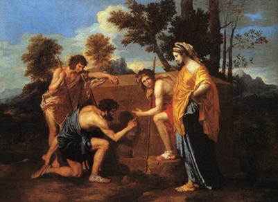
Shepherds of Arcadia II : Hercules, Bootes and Astraea
Virgo is also adjacent to Bootes, on the other side from Hercules, and so the most likely identity of the lady standing behind Bootes in Poussin's Shepherds of Arcadia II is Astraea, the golden mantle symbolising the Golden Age. She is appropriately depicted surrounded by Arcadian Shepherds both because Bootes as Ikarios and Daphnis is indeed a herdsman and because the people of Arcadia and their culture were said by some, such as Pausanias, to be the oldest of people, older even than the Moon, which traces them back to the Golden Age. Thirdly, Virgil's IVth eclogue describes the return of the Golden Age with the birth of a divine child, and while the Golden Age necessarily means also the return of Justice, who had fled to the sky when it ended, by the High, or the latest the Late Renaissance, the bucolic life of Virgil's poetic shepherds was idealised because it has been shepherds who had been the first to hear, by the prophetic insight of the rustic bard, of the birth of the divine child Christ. I am introducing this here as in a moment we shall be able to see that Astraea, i.e. the goddess Justice, turns out to be the key to understanding the context of the "blade" and the "chalice", and we shall even see why Astraea would be associated with the Rennes-le-Chateaux region.
What is certainly true is that Louis the Sun King himself took an extraordinary interest in this painting, going to extreme lengths to acquire it at enormous financial cost after he had confiscated letters written by his Superintendant of Finances which spoke of some great mystery of which its painter, Poussin, was aware. The reason this is anomalous as regards the official history is that The Shepherds of Arcadia II was painted in the early half of the 1600's, while the official mapping out of the Paris Meridian occurred considerably later in that century, so if the mystery Poussin wished to declare related to the Meridian, something funny is going on.
And did Paris just happen to be on a longitude line that extends from what had by then become the most northerly to the most southerly points of France, as the boundaries by this point had been fixed? It seems quite possible that whilst the cartographic survey was carried out for the first time in this later period, the basic notion of the Paris Meridian was based on something with a somewhat longer history.
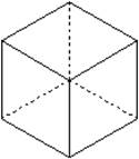
I also found it interesting that the Seal of Solomon pattern can indeed be related to the Rennes-le-Chateaux mystery in material preceding even Plantard's image of the sword along the French Meridian. In the bookplate designed by Sauniere, the priest who is said to have discovered the treasure and the secret parchments of Rennes-le-Chateaux, look carefully and you shall see the dot in the centre of the cross is in the Paris position, a direct reference that, it seems to me, cannot possibly be just coincidental, and the other dot in the middle of the centric circles is exactly in the equivalent Roslin location, i.e. at the intersection points along the central vertical/meridian.

Sauniere's Bookplate based on the Solomon Seal
Reason demands that another question be answered: when did the map of France become hexagonal? Actually, analysis of the changing shape of the country over the years shows that from the Middle Ages up to the eve of the French Revolution the shape, rather like a snowflake forming, gradually became more and more hexagonal until she reached the shape she has today. It was also upon the eve of the Revolution that the great cartographic survey of France begun in the Sun King's time was finally completed. Then when Napoleon came into power the borders suddenly expanded as a result of the conquests. However, after the defeat of Napoleon at Elba a group of European royals and their officials met in Vienna and, as well as taking in the odd Beethoven performance here and there, came up with new agreements about the European borders, and in the case of France this resulted in the shape of the nation reverting as if by elastic memory to a hexagon. It was a royalist meeting that didn't have democratic aims high on its list, but it did result in about a hundred years of peace between European nations, quite a significant result.
Then there was that question of how the Louvre pyramids could be a key to all this, when they were built only recently. Plantard's map with Meridian blade and hexagram, and also Sauniere's bookplate, give evidence that this scheme was known by some in recent times, which also makes it possible that the builders of the pyramids did have this same scheme in mind. In fact, the Louvre pyramid complex was commissioned by President Mitterand as part of his Grands Travaux or 'Great Works' programme, which also included the intriguing Monument to the Rights of Man and the Citizen. This monument includes, amongst other things, two bronze figures based on the shepherds in Poussin's painting, a shaft aligned to the Sun due south at the Summer Solstice, Masonic symbols and two obelisks. In light of this it would be difficult to claim that the Grands Travaux project including the Louvre pyramids lacked occult significance! The Travaux project also includes the massive Grand Arch of the Defence in the shape of a giant cube. In fact, the glass pyramid was actually the fulfilment of a long-standing plan for a Parisian pyramid, with various versions of the plan being the 'Cenotaph dans le genre égyptien' of Etienne Boullée, and the great pyramids planned by the Freemason Nicholas Ledou. Indeed even before Napoleon, during the reign of Louis XIV a pyramid to the glory of the Sun-King had been proposed for the Cour Carrée of the Louvre by architect Francois Dubois, and later a large baroque pyramid with a statue of Napoleon on top was designed by the architect Louis-Francois Leheureux to be located on the exact spot where the glass pyramid now stands! Details of these plans are given in the penultimate chapter of Talisman, the 2004 book of Bauval and Hancock. It seems that whether it was the king or the emperor of a republic – or indeed a 20th century president – was far less important than the real aim – to get a Paris pyramid erected here. This was partly because they believed that the Great Pyramid of Egypt stood on an Ancient Egyptian prime meridian that bisected the Nile Delta. But what ultimately got built also had the inverted pyramid, a symbolic reference, it would now seem, to the location of Paris at the ¾ intersection point along the French Meridian.
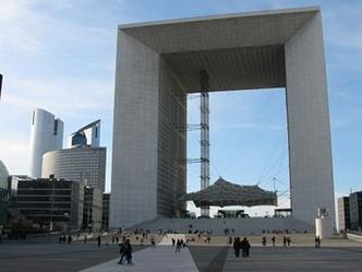
The Grand Arch of the Defence
So, for goodness sake, what is this business of the "blade" and the "chalice"? We've already seen that Plantard's map shows a sword stretched across the map over that Seal of Solomon pattern which has become associated with the Jerusalem Temple, while in the Bible a sword stretched across Jerusalem embodied the "wrath of god". Perhaps this is why the sword came to be associated with Justice, as personified by the goddess Astraea, for in the Renaissance Astraea was most often shown holding not only the scales in one hand, but also the sword in her other hand. Justice is one of the Four Cardinal Virtues that were mentioned in works by Plato, and this theme was then taken up by Jewish, Christian, Medieval chivalric and Florentine NeoPlatonic traditions. Here at last is a level of research into this business that appeals both to my Reason, in that it sheds light on the origins of the concepts in this mystery within both Medieval and later Renaissance contexts, and appeals also to my Mind, my Mens, in the higher NeoPlatonic, 3rd Eye sense. The other Cardinal Virtues are Temperance (exercising moderation where appropriate), Strength (having fortitude, endurance), and Truth.
Why do these give us the key to understanding not just the "Blade", but also the "Chalice"? In Florence these Four Cardinal Virtues became associated with the Four Suits of Tarot/playing cards: Temperance, symbolized by wine being mixed with water, being associated with Cups, Strength associated with the Rods suit, and Truth with Mirrors (Coins). And surprise, surprise: it is a Florentine book dedicated to Catherine de Medici (of Louvre fame) that gives us evidence of a card game in which the four suits were associated in this way with the Cardinal Virtues. (One Hundred Liberal and Ingenious Games). The Florentine church of San Miniato al Monte, dating from the century before, (i.e. the 1400's, when the chapel at Roslin was also built) has four angels at the four corners of the ceiling each carrying one of these emblems of the Four Virtues, as noted by Paul Huson in his book Mystical Origins of the Tarot.
So then, the Cardinal Virtues are associated with the Four Cardinal Directions, E,W,S,N, and we have seen the Sword of Justice coming from the South, and the Chalice of Temperance in the North. The Rod of Strength and the Mirror of Truth must have been in the East and West, and it is intriguing to see now how Astraea would be associated consequently with the southern end of the Meridian, including the Rennes-le-Chateaux region…so much for Holy Grail and the bones of Mary Magdalene, not withstanding that Mary with her alabaster jar looks a little like the Tarot card of Temperance.
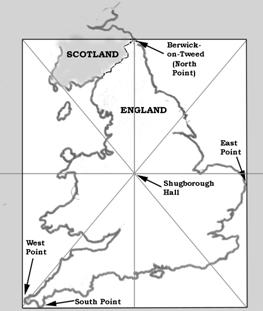
And now that I had come this far, there were other questions that simply could not be ignored. For example, if Poussin's Shepherds II painting really does have some connection to these Meridian Mysteries, what significance is there in the fact that a copy of this painting was produced in stone relief on a mysterious shrine in the gardens of Shugborough Hall in the English Midlands?
The Mystery of Shugborough Hall
So, the same Poussin painting that we looked at in connection with the French Meridian, The Shepherds of Arcadia II, is copied, with some variations, in the Shepherds Monument of Shugborough Hall in Staffordshire, north of Birmingham. Another link with the French scheme is that a pyramid has been added above the tomb in the image, just as it has been built in Paris.

The Image from the Shugborough Shepherds Monument
Shugborough is at 2 whole degrees west of the Greenwich meridian, so that the Sun is due south exactly eight minutes later than at Greenwich. But there is more to it than that. If this longitude line is extended due north from Shugborough, it goes directly through the town of Berwick-upon-Tweed, the sharply defined northernmost town in England, also at exactly 2 0'0'' West. So just as with the Scottish and French geodetic schemes, Shugborough is on a meridian line that extends to the northernmost point in the country. And what is more, it seems that this longitude line was chosen as the one on which the north point should lie because it is exactly half way between the most easterly and most westerly longitudes of Britain. Its positioning half way between British East Point and West Point is what governed its choice as the English 'Rose-Line', and then the English border was extended north to the point where this meridian line touched the coast, and this place brought within England for this reason, to make it the northernmost point.
The place of cultic fame on the English line is near to that line's centre, namely Shugborough Hall. So this site is both halfway between East Point and West Point and also about halfway between South Point and English North Point.
The English royalty negotiated a special deal giving the northern-most town of England (Berwick-on-Tweed) a unique dual Scottish-English status, so that it could be 'of England but not in England', suggesting that the English really wanted this town even if it meant bending the rules of nationality. James IV of Scotland is reputed to have proclaimed this dual status as he crossed the bridge of Berwick on his way south to be crowned James I of England.
The existence of a thinly veiled reference to the plotting out of meridians in the third initiation of Freemasonry – the plumb bob at the south gate at noon – greatly supports the theory that it was Royal-connected proto-Freemasons that plotted, or rather re-plotted out the north-south 'rose-line' of England.
A connection to this English rose-line may perhaps be found in Shakepeare's work. On the Internet a certain Paul Smith has put together a very useful list of dates that connect to the Et In Arcadia concept, and one of the entries reads:
1975
Harry Morris, As You Like It: Et In Arcadia Ego (Shakespeare Quarterly, Washington DC, Vol. 26, Nr 3, pp269-275).
Rosalind: "Well, this is the Forest of Arden".
Touchstone: "Ay, now am I in Arden".
William Shakespeare, As You Like It, II.iv.11-12.
It appears that an article appeared in the Shakespeare Quarterly of Washington in 1975 drawing attention to the similarity of the line 'Now I am in Arden' to the 'Even in Arcadia I' carved on Poussin's tomb. It is surely also worth noting the similarity of Rosalind to 'Rose-line'. The reason this is significant is that the Forest of Arden, which was once bigger than it is today, encompassed a region through which this English rose-line does indeed run. We might even note that on the Scottish rose-line Edinburgh seems once to have been called Eden Borough, according to Oxbrow and Robertson, and that Arden is similar to Eden.
You might have thought that three sacred meridians would be enough, but there is just one more that calls for our attention.
The Greenwich Meridian
What comes as a real surprise is that similar mysteries pertain to the current international Prime Meridian, that of Greenwich in the East End of London. As with the Louvre in Paris, London too has its modern pyramid, namely the one that is raised up high on the top of Canary Wharf on the Isle of Dogs not far from Greenwich. The Greenwich observatory was designed by Sir Christopher Wren for Charles II as a counterpart to the Paris observatory built for the Sun King, the one that had the meridian going through it, and in England too the meridian goes through the observatory.
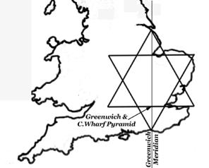
And sure enough, if we measure along the Greenwich Meridian line from where it reaches the sea at the south coast and to the north at the entrance to the Humber Estuary, we then find that Greenwich, where this line crosses the great old Thames just east of the Isle of Dogs, is ¾ of the way along, a repetition of the same Seal of Solomon ratio as used in Scotland and France for the sites of Roslin and Paris! This line is where international time begins and ends, reminding us of Blake's line telling us how all things begin and end on Albion's druid rocky shore, and this this Seal of Solomon pattern of course links into a once widespread Blakean tradition of London as some kind of New Jerusalem. But this is not to be taken in the sense of a Zionist plot, after all it is from the Arab take on the story of Solomon that the traditions concerning this pattern derive, and it is simply in the literal translation of Jeru-Salem as 'City of Peace' that it is best viewed. In fact in these sensitive times we may be safest dropping entirely any use of the name Jerusalem, and using instead simple English terms. The place where the Greenwich Meridian meets the south coast is in fact called Peacehaven, complete with its Greenwich House and Meridian Leisure Centre to mark the fact. The Meridian passes close to Edenbridge on its way up towards Greenwich, reminding us again that Edinburgh in the Scottish scheme was once called Eden Borough, and of the forest of Arden on Rosalind's Shugborough line. In the Middle Ages the floodplain south of Lewes was flooded, so that Lewes was effectively the place where the Meridian, if it had existed at that time, would have been located. I recently attended a workshop in Lewes given by Phillip Car-Gom, the head of the order of Bards, Ovates and Druids, a resident of Lewes, and he mentioned that Lewes was the site of the first Templar church in Britain, the Church of the Holy Sepulcher (named after the church in Jerusalem most sacred to Christians) and he mentioned a little-known legend that this church in Lewes was the location of the Holy Grail. As the place where (in Templar times, since this was the meeting with the sea then) the point of the 'V' of the lower triangle, or 'chalice' of the Seal of Solomon would have been located, this Grail story is quite appropriate.
The Greenwich mystery looks more and more interesting as we look into it more deeply. The history goes back way before Charles II commissioned the observatory by Wren. The land came into the hands of Humphrey, Duke of Gloucester and Regent of England (effective king) in 1427, and he started building a palace by the river at Greenwich, named Bella Court. He was a learned humanist scholar who was in communication with the leaders of the new Italian humanism, had copies of Plato in his library and was a patron of scholars and men of letters, just as was William St Clair of Roslin in the same period. Humphrey was called 'Good Duke Humphrey' rather like the 'Good King Rene' of Anjou who was a champion of the Renaissance idea of Arcadia and also, like Humphrey, in contact with the movers and shakers of the early Renaissance, such as the Medici. In fact Rene is a clear link between Greenwich and Roslin. William St Clair is thought to have had direct links to Rene I of Anjou; they both appear to have been members of the royal knightly Order of the Golden Fleece, and certainly William commissioned his scholar Gilbert Hay to translate works by Rene. Greenwich too has its links to the House of Anjou. When Humphrey of Gloucester died in 1447 and the manor reverted to the Crown, Margaret of Anjou, a direct descendent of Rene, decided to adopt Bella Court as her place of residence. Margaret was the wife of the English King Henry VI. This year, 1447, was the year after William St Clair started building Roslin.
Margaret was the daughter of Rene of Naples, Duke of Anjou, King of Naples and Sicily and Isabella, Duchess of Lorraine. Roslin for its part would later be visited by Mary of Guise, also descended from the House of Anjou, who as we have seen, visited and wrote of a 'secret' there.
The palace at Greenwich was renamed Placentia, from the Spanish word meaning "Pleasant Place to Live". It went on to be the principal Royal palace for the next two centuries, during which time it was extensively rebuilt. Skipping over various royal connections, we come to the reigns of James I and Charles I during which time The Queen's House, designed by Inigo Jones, was erected at the site, highly significant in British architectural history since it was the first classical building in England.

Then in 1660 Charles II, himself the grandson of the Louvre-born Marie de Medici, had Placentia rebuilt in the new classical style, and he founded the Royal Observatory there in 1675. The Royal Naval hospital was also built at the site as a place for retired seamen, another fine classical building built by Wren, and shown here as painted by Canaletto. Within it is the Painted Hall, a masterpiece of decoration said to be the finest dining hall in the Western world.
In summary, Dan Brown was at least correct about one thing: there is more to the Mysteries of Roslin, the Louvre and Rennes-le-Chateaux than a mere 20th century hoax.
In 1884 at an international conference the Greenwich longitude was chosen as the international Prime Meridian. In 2012, of course, an event that in ancient times was held by the banks of the Alpheus, the river of Arcadia, is to be held by the Thames at Greenwich as the torch of Olympia travels here after journeying around the world. Et In Arcadia…
Amazing, amazing stuff……..