


Here we shall look first at seven British landscape mysteries, and then describe the treasure hunt that brings them together, the detective story that leads to a really rather surprising unified theory. The piece follows on directly from the earlier Forum post :
The Balance of the Two Lands: Ancient Egypt's Division According to the Ratio of Triangular Equilibrium (16 April 2008). It could be viewed as Part 2 of that discussion.
Finally I will pose a riddle and invite you to doing some sleuthing of your own, emailing your solutions to [email protected]
Seven Mysteries
Mystery 1:Beads and Barrows
Faience is a type of fired sand paste which when treated with certain glazes creates a vivid blue-green effect. It was first made in Egypt and the Near East, and beads of it were given a name in Egyptian which means "good luck". For this reason it was commonly buried with the dead to assist them on their journey.
It wasn't long before faience found its way to the British Isles, where, similarly, it was placed with other funeral goods in certain round barrows.
There are other examples of British Bronze Age grave goods curiously similar to those of Egypt. In 1955 a burial tomb in the Hill of Tara Complex in Ireland was opened by archaeologists to reveal a necklace of amber and faience beads. Qualified Egyptologist Lorraine Evans has said that this is remarkably similar to necklaces found in royal burials in Egypt, such as that of Tutankhamun. This is interesting enough in itself, but interest becomes sheer fascination as we note, as Evans did in her book Kingdom of the Ark, that an old Scottish myth traces the ancestry of the High Kings of this Tara site back to a daughter of a pharaoh who, according to this myth, lead an expedition to the British Isles. The site where the necklace was found – Tara – has always been associated with this dynasty. An almost identical necklace (again similar to the Egyptian, in other words) also turned up in a tomb in Devon, England, in 1889.

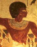
The Gold of the Grail Kings: The stunning gold shoulder cape found in a 4000-year-old burial mound in Wales, and, right, an image of the ka of an Egyptian wearing a similar adornment in a tomb painting.

Gold collar on a ka statue from the tomb of Tutankhamun.
Then there is the extraordinary Mold Pectoral, one of the most amazing finds of British archaeology, and the largest single piece of worked gold ever uncovered at a British ancient site. It was found in a Bronze Age burial mound in Mold in Flintshire, North Wales, in 1833. Evans noted that it bares an uncanny resemblance to gold pectorals that formed part of the funeral garb of high-ranking members of Ancient Egyptian society. Even the use of a beaded pattern worked into the surface of the gold was familiar to the British Egyptologist. The gold collar of Egypt was purely funerary, and was held to bestow new life and fertility to the occupant of the tomb who wore it. The British example, despite incorporating such a large amount of solid gold, was surely also made only for the Afterlife, for its form would have completely restricted upper arm movement and so could not have been intended for use by a living person. As such the Mould Pectoral represents a phenomenal investment in the welfare of this individual in the Afterlife. So not only does it resemble the Egyptian collars, but it also clearly had a similar purpose.
What was the source of these cultic connections? Evan's suggestion is not unlike that cry of "wolf" that went up the third and final time from the boy in the old fable. Because the previous calls had been false, no-one believed the true one. With a religion and classical literature in neither of which Britain figured, our recent British ancestors attempted to correct this cultural dislocation by imagining themselves to be first the New Trojans, to link themselves to the richest literary traditions of the Classical World, and later inventing the British Israel movement, to link themselves to the Bible upon which they had been spoon-fed. The culture of a nation must interpenetrate its landscape, and every culture must have a mythology, even if it calls it "history". However, false histories never have the same resonance as those which have levels of truth; an abducted Helen will lead to a fallen Troy. How ironic would be if the Egyptian claim actually turned out to have historicity?
Evans did not allow her enquiry to probe back before the Middle Bronze Age period, but the Tara tomb itself (although probably reused) was early, and there is much else from the earlier period that we should take into account, and our business here is to look at that.
Mystery 2 : The British Primordial Mound

Silbury Hill, the 'British Pyramid' – largest Neolithic 'mound' in Europe, started around 4,700 years ago in the same era as the Great Pyramid.
In the British Early Bronze landscape nothing stands out so clearly as being unique and anomalous as the enormous man-made structure of Silbury Hill, west of Marlborough in Wiltshire. You would have had to have traveled all the way to Egypt to find something similar, and archaeology now states, through the most up-to-date carbon dating techniques, that it was indeed built at the same time as the Great Pyramids of Giza. The hill is a well-balanced structure, symmetrical even, with a flat platform at the top, and underneath the turf covering has a stepped structure like an Egyptian stepped pyramid. It was built from chalk blocks and the engineering and architectural skill involved was considerable, with no precedent in Britain.
There is good reason to believe that the hill was constructed as a representation of the Primordial Mound, and not just because it was surrounded by a lake like the primordial waters. There is something deeply curious about the hill's exact latitude, for the latitude line precisely 4/7 of the way from Equator to Pole runs right through the hill. This connects it with other Primordial Mound sites of the Ancient World. Delphi, the greatest of the Greek oracle centers, is located on Mount Parnassus. There was a version of the Deukalion myth where this Ancient Greek Noah figure landed his ark on Mount Parnassus, it being the first mountain to rise above the waters of the flood, just as with the Primordial Mound of Egyptian Myth. Indeed, Parnassus is at 3/7 from Equator to Pole, while the Theban Primordial Mountain, the sacred mountain of Thebes in Egypt known as Mistress of the West and sacred to Hathor, is as 2/7. Silbury, at 4/7, actually matches Egyptian depictions of the seven-stepped Primordial Mound. At Thebes an annual festival was held in which statues of the god Amun as a ram-headed figure were carried about in a crescent shaped boat. Similarly, at Delphi there was a festival in which a crescent shaped boat was carried, and this boat was known as the Argo, the same name used for the boat which carried the golden fleece of the Ram. Indeed, one version has the Castalian Spring of Delphi as the place where the dragon lived from whose teeth were sprouted the Earth-born warriors we find in the Argo myth. And furthermore, Herodotus says that in Egyptian Thebes once a year a sacred ram was sacrificed and its fleece was draped over the statue of this Theban ram god, Amun. These coincidences may be explained if there is truth in the stories told by Herodotus in which the Greek oracle centers were founded by visitors from Egyptian Thebes. Certainly there was also an oracle at Egyptian Thebes, as there was at Delphi, and in the Theban temple of Amun there was even an equivalent of the omphallos stone of Delphi that was said to have been placed at this spot after Zeus had measured the size of the Earth. Since the Earth-measuring that links Egyptian Thebes and Greek Delphi is the seventh divisions of the hemisphere, would you call me a fool if I were to make the same claim for the seven-stepped hemisphere of Silbury that Herodotus made for Delphi, namely that it was built according to the commission of Egyptian visitors? In which case, perhaps it was you that were the fool. (You may be interested in exploring these matters with reference to the Hindu/Tibetan concept of the dwipa.)

Right: Egyptian stepped Primordial Mound depiction.
Left: 'Mistress of the West' – the sacred peak of Thebes
Mystery 3 : Henges and Cursuses
This Silbury Hill is in fact located within a group of prehistoric landscape monuments known as the Avebury Complex. This includes the large East and West Kennet Long Barrows, several round barrows, the site of a vast palisaded enclosure, and long avenues of megalithic stones leading to, of course, the massive Avebury Henge and stone circle – the largest of the stone circles, to be sure.
The word henge is now used to refer to a large circular ditch and bank earthwork. The henge of Avebury is built on a gigantic scale, banks big enough to toboggan down, and a total circumference long enough to make a Sunday afternoon walk. The ditch may have been water-filled, and the great bank was not grass-covered, but shone as a circular wall of white chalk. This henge and Silbury Hill just a mile to the South were under construction in the same period. It seems inconceivable that they were products of separate commissions.
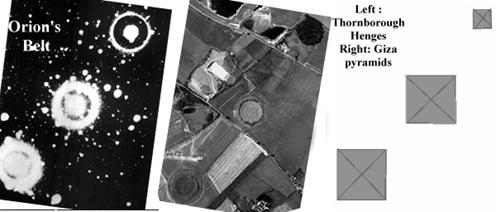
There are of course other examples of large henges in the British Isles, one of them forming the earlier phase of Stonehenge, for example. But the national capital is the site of Thornborough in North Yorkshire, the so-called "Stonehenge of the North". The Thornborough complex is built to massive proportions, and is certainly impressive. The core of it consists of three large henges linked by two long straight cursuses. A cursus is a long, straight avenue bounded by banks. The Thornborough Henges have an interesting structure. Each of them has two circular ditches with banks placed concentrically and the banks were covered with locally sourced white gypsum, rather as the Great Pyramids of Giza were originally given an outer covering of white limestone that shone brilliantly in the Egyptian sunshine. It seems logical to concur with archaeological opinion when it proposes that this white covering was given to the Thornbourgh Henges in Yorkshire in order to replicate the effect produced by the chalk banks of southern henges, and there is a close link to one of the southern sites in particular. At Dorchester-on-Thames the huge Big Rings henge likewise consisted of two concentric circular ditches with banks, and again a long straight cursus linked to the henge, and both the Dorchester and Thornborough henge sites are located on floodplains adjacent to rivers. This has lead to the conclusion that the same builders were involved, despite the great distance between the two sites. Why were these two sites in particular singled out by these builders, these lovers of shining white walls?

A crop mark aerial photo of the great Big Rings double henge of Dorchester-on-Thames
The three henges that form the core of the Thornborough complex are configured intriguingly. Whilst the henges that join the three together are themselves straight, they are slightly off alignment. This makes the ground plan strongly reminiscent of the three Giza Pyramids, and, of course, the three stars of the prominent asterism called Orion's Belt located on what we might call the floodplains next to the River of the Sky, the Milky Way. Indeed, the orientation of Thornborough has been calculated to have aligned with the rising of Orion. The theory linking Thornborough with Orion was first put forward by university academic archaeologist Dr Jan Harding.
Mystery 4: The Pilgrim Path
In the heady 1960's a realization dawned on Earth Mysteries investigator John Michel as a kind of mystic vision. It concerns Glastonbury Tor, the evocative, enigmatic and prominent man-sculptured hill that rises above the Somerset levels, inspiring legends down through the ages. The hill itself is an elongated teardrop shape in plan view, and the old Pilgrim Path runs straight along its long axis. Michel knew that the tower on the Tor was once part of a church dedicated to St Michael, and he got a feeling that the long axis aligned to another mound capped by a St Michael tower off to the southwest, Burrowbridge Mump. Checking out this alignment he found that it did indeed run along the Pilgrim Path, and that in the other direction it went to the site of the afore-mentioned Avebury Henge, and then continued over the landscape to pass near to the Dorchester-on-Thames site also mentioned in Mystery 3.
A further realization then came to Michel – the line if extended ran from approximately the most westerly point on the Cornish Coast up to approximately the most easterly point in Norfolk, making it the longest East to West line that can be followed over the land, and he also noticed it following quite closely parts of the Old Icknield Way in the more easterly counties. He called it the St Michael Line and it generated a lot of public interest.
Mystery 5: The Old Road
The Icknield Way, the old road that follows the course of Michel's long alignment, runs during its chalky Chilterns section close to and often parallel to an even older track: the Ridgeway. This track has been called Europe's Oldest Road. Its course takes in some interesting ancient sites such as the Whiteleaf barrows and the great long barrow called Wayland's Smithy. The end of the Ridgeway is actually located next to the afore-mentioned great mound of Silbury Hill in the Avebury complex that we looked at in Mystery 2. The Avebury structure appears from archaeology to have been completed by people who had adopted the round-barrow building Beaker Culture, and a Beaker burial has been found in the Whiteleaf Cross region, and since the Ridgeway itself was also in existence at that time we know that these builders walked its length, and can reasonably assume that it was a sacred pilgrimage route of some kind.
Mystery 6: The Two Staffs
As the Whiteleaf Cross chalk hill marking is on the Ridgeway, the chalk giant known as the Long Man is located along the course of the old chalky track of the South Downs Way, near the village of Wilmington, in East Sussex. Once carved into the chalk, it is now marked out with white bricks. Its age is till unknown. Scientific dating was recently done on chips found lower down the hill, but it is acknowledged that the most likely origin of these chips is the old quarry adjacent to the figure, rather than from the figure himself.
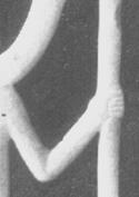
The pose of the Man, with his hands raised to shoulder level, palms flat and facing upward, immediately suggests Egypt, and indeed as we note the form of the Long Man, we can see that there are in fact some intriguing iconographic parallels from that land. Compare the Long Man with, for instance, this image of a double-serpent bearing figure in the night sky from the ceiling of the Temple of Hathor at Deir el Medina.

This image of the double serpent bearing figure is a close up of a drawing that was done by Lepsius' draughtsman, and it shows the ceiling of the Ptolemaic temple of Hathor-Ma'at in Deir-el-Medina. When Lepsius and his team travelled through Egypt in the Nineteenth Century, his draughtsman produced many accurate, faithfully reproduced drawings of the temples and their artwork based on what was then visible. These drawings have proved invaluable to Egyptology, because much of the artwork has since deteriorated due to the carbon dioxide from the breath of millions of tourists over the years, greatly affecting the colours of the ancient paints. Is some trace of this figure still present on this ceiling? It would be interesting to investigate, but here the image functions just as an introductory formic analogue to the Long Man, who holds staffs rather than snakes, while there are other Egyptian images that actually grasp two staffs, and it is these that we shall consider in more detail. (As Graham H reminded me, this serpent bearing figure is interesting for other reasons – such as the uncanny similarity to the figure on the Gateway of the Sun at Tiahuanaco – but this would lead us into a tangential investigation.)
Two staffs in Egypt could represent the Two Lands, Upper and Lower Egypt, and as a simple development of this a figure with two staffs could represent the favorite Egyptian theme of the "Balance of the Two Lands", the place found by measurement to be the boundary between Upper and Lower, and which geodetic measurement thus resolved the drawn-out and nationally destructive mythological dispute between the gods Horus and Set. Examples of a double-staff bearing figure are shown here, in the long necked amphora from Tutankhamun's tomb treasures and a similar image from the temple of Denderah.


For more on this see The Balance of the Two Lands: Ancient Egypt's Division According to the Ratio of Triangular Equilibrium
In the long-necked amphora piece shown above there are also two staffs framing the left and right of the upper register, and these take the form of palm ribs. This is a reference to another figure traditionally shown in Egyptian art carrying a staff in each hand, namely Heh, the personification of Eternity. The palm ribs are a year symbol which, in concert with the tadpole symbols for infinity at their bases, represents Millions of Years, or Eternity.

Heh clutching two palm ribs
Heh in this form features again in the Tutankhamun treasures, and in one example that is relevant here he appears with his two palm ribs on the handles of a lotiform calcite cup. Lotuses form the handles and Heh stands on these, rather as do the Four Sons of Horus in other images, who are associated with the "indestructible" circumpolar stars of the Northern Sky, and indeed the cup's inscription reads:
May thy Ka live and mayest thou spend millions of years, thou who lovest Thebes, sitting with thy face to the north wind, thy two eyes beholding happiness.

Tutankhamun's Lotiform Grail with Heh on the Lotus-bloom handles, kneeling on neb symbols, and holding ankhs – the whole representing the sweet life-giving winds of the North
Why is this relevant to the Long Man of Wilmington? The reason is that his orientation on the flat hillside is such that he gazes up to the circumpolar stars of the northern sky.

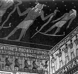
In the diagram I've shown the circumpolar region as the enthroned Osiris sitting before the lotus with the Four Sons of Horus. But isn't Osiris identified with the constellation of Orion, who stands upright when to the South? If we look at the images worked onto the gold shrine of Tutankhamun, we see him hunting in the Field of Reeds – Orion stalking the southern skies, I suggest – and also we see him hunting with bow and arrow with lion crouched at his side, and we see him enthroned. Leo is rising in the East when Orion is due south, and at the same time – i.e. the same time when Orion is in the South and Leo in the East – at this time of the night Casseiopia, as a throne, is the right way up in the Northern Sky (while at other times during the night the chair is on its side or even upside down). These, as I see it, are all equivalents of ka images of Osiris, the deceased king. The purpose of a ka image was to invoke the essence of enduring eternity in the Spirit Double body of the deceased, through connections to geometry and the fixed constellations. The deceased would have several different ka paintings and statues in different poses in the tomb – all in standard postures, including fowling with throwing stick in the marshes – and likewise Osiris can just as easily be sitting on the throne in the North, or with his lion in the East, or fowling in the South. That these three are all in their places and the right way up at the same time during the night strengthens the theory of a connection to a First Time, a time of Ma'at. When one is standing outside on a clear February evening in the current period, this configuration, redolent of the perceptions of the ancients, can evoke an extraordinary, numinous feeling, as we see Orion striding west in the South, then turn to see the beautiful Form of the Throne in the Northwest, right way up and facing the Pole. Things are set aright, returned to how they should be, the Scales of Ma'at rebalanced, with the image in the Southern Sky standing upright, and the chair in the Mansion of Osiris also the right way up, and Leo in the East as it was at dawn in the First Time: Osiris is on his throne and all is right with the world.
So, returning to the question of the sweet, life-giving winds that blow from the North in Egypt, we may note that Tehuti (Thoth) is in fact shown holding the was-ankh-was over neb grouping in the "Book of the Dead" (below), as an accompaniment to a text that describes the good things Tehuti did for Osiris, including resolving the battle between the "Two Fighters", Horus and Set. This text includes the words: "I come to you son of Nut, Osiris, ruler of eternity. I am one of the followers of Tehuti; I rejoice at all he has done. He brought you the sweet winds for your nostrils to give you life and he brought the beautiful wind to your face, which comes forth from Tumu [Eternity] for your nose."

Tehuti with was-ankh-was over neb
So here we see Tehuti "giving life", represented by the ankh, and we learn that he has done this by bringing the sweet winds, those that blow from the North. How is this linked to resolving the battle between Horus and Set, these "Two Fighters"? Well the same text, the one which the picture accompanies, also includes the words: "He (Tehuti) destroyed storms and whirlwinds for you. He caused the Two Fighters to be gracious to you." So it seems that the sand-carrying desert storms which blow in Egypt, apparently around April and May, were seen as being the result of the battle between Horus and Set, and because it was Tehuti whose measuring resolved the dispute, he was seen as the one responsible for ending the storms, and returning the peaceful state of weather, which in Egypt is the steady winds that blow from the North. The was-ankh-was can therefore be seen to be the balancing of the Two Powers – the was scepters – resulting in the sweet winds that bring life, the central ankh. The neb may in fact be 'Lord' after all – Lord of the Balancing of the Two Lands which Gives Life. Epithets of a similar type are known for high-level scribes. So Tehuti brings life back to Osiris. Ankhs are sometimes shown holding fans – this is certainly the case in the decoration of a fan found in Tut's treasures – fitting with their link to the breezes that bring breath back amid stifling Egyptian heat.
Returning to the lotiform grail, then, we can see that here Heh represents the sweet, cooling winds of eternity that blow gently from the North when the Two Fighters have been put in their respective zones by means of the Balancing of the Two Lands.
The lotus on which the Four Sons of Horus stands (a circumpolar constellation) is usually shown blooming in front of the Throne of Osiris. The throne constellation of Cassiopeia is a circumpolar constellation, for which reason it seems to me likely that this and the Throne of Osiris are one and the same. In another of the treasures of Tutankhamun we see the king enthroned like Osiris and being presented with the two palm ribs plus tadpoles representing millions of years by a female figure in Long Man pose, and the inscription tells us here the king is "given life".

Also shown above is another scene from this same artefact, the golden shrine of Tutankhamun. Here the king is hunting like Osiris in the Field of Reeds of the afterlife, with a stick raised above his head, ready to throw at waterfowl rising out of the marshes. The posture he has assumed here was a standard Ka image, used in wall paintings in tombs.
The Golden Shrine on which the above scenes were worked was built onto a sledge, associating it with an Otherworld location called Rostau, the place of dragging. Here again could be a figure with a raised stick, this time driving the cattle that pull the sledge. Since Orion is traditionally shown with a raised club in this same pose, and he follows closely behind Taurus across the night sky, and is associated with Osiris who hunts int he fields of the Afterlife, and since the journey to the Afterlife involved a passage into the West, could the ferrying represent this gradual movement of these constellation from East to West along the path of the ecliptic? They key thing to observe here is that now it is not a throwing stick that is brandished, but just a wooden stick, a club.

Ferrying the deceased through Rostau, (with Orion and Taurus?)
A straight track has been cut into the side of the hill of the Long Man, leading up to the area on the hilltop above the giant where round barrows are located. We might choose to imagine the deceased on a sledge being dragged by oxen up to this burial place.
And while we are discussing the Long Man, this may also be the place to mention a certain artefact found just to the other side of the Long Man hill, in Friston. Now on show in the Lewes museum, the piece in question is a finely crafted polished ovoid mace-head made from a hard stone with marbled streaks running through it. Such streaked stone was often chosen in Egypt for similar finely crafted polished rounded mace-heads, which could also be ovoid, particularly during the Proto-Dynastic period (Naqada II and III). A mace, by the way, is a shaped lump of hard stone attached to a wooden handle. In Egypt the mace had symbolic connotations and functioned as an insignia of power held by high-level officials and the pharaoh. It is therefore interesting that archaeologists looking at this piece from Friston conclude from the fine workmanship – the same symmetrical curvature evident in the Egyptian examples – that it 'was probably originally made to serve as a symbol of authority', despite the fact that the 'flattened and battered base shows that it was also used as a hammer at some period.' In the simplest terms, the fine craftsmanship and rare ovoid shape of this piece make it a direct parallel to the Egyptian finds, which would be interesting enough anyway, but together with the location of the find at Friston, literally just over the other side of the hill from the highly Egyptionesque chalk figure of Wilmington, it becomes a very interesting object. Mace heads do turn up in British archaeology, but this ovoid example is 'extremely rare'. British examples were not normally polished in this way. (The Lewes Museum also has a sizeable faience pendant from a burial mound at Clayton on the Downs north of Brighton.)
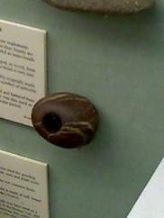

Left, the fine Friston mace head. Right: Egyptian early mace head.
Below left, Proto-Dynastic image of Egyptian king holding mace raised in the Orion-like "smiting" pose.

Mystery 7: The Club-Bearer
Follow the ancient chalky Ridgeway and it will take you to the site of the Whiteleaf Cross chalk hill marking in Bucks. The Ridgeway also detours to the White Horse of Uffington, known to be ancient, on the way to the Avebury complex, where it finishes at the sacred circle called the Sanctuary, near to Silbury, that hill of chalk blocks. From the Sanctuary the avenue of stones then leads on into the Avebury Henge, once a gigantic ring of bright chalk. From here another long distance path leads out across the landscape: the Wessex Ridgeway. Mostly following an ancient route, this will take you at last via a meandering route to the village of Cerne Abbas, the site of another chalk hill figure.
Here is the Long Man's brother, the other British chalk giant. The "rude" giant of Cerne Abbas stands naked on the hillside brandishing a club above his head. Again, the age of the figure is a complete mystery. As regards his identity, we may be able to hazard a guess.
Of all the figures of mythology there is none that matches the Cerne Giant half so well as Orion the Hunter. The other Club Bearer of mythology is Hercules, but he is traditionally shown in a kneeling position, and he was not a giant, while Orion most certainly was. He was in myth one of the giant sons of Poseidon, and he is of course a constellation, the brightest in the sky in fact. In his constellation he is shown in the very posture depicted by the Cerne man. Orion the Hunter with his hunting dogs Canis Major and Minor turns up in British tradition as Welsh Arrawn the hunter with his white hounds of the Otherworld (pronounced "Ar-ah-oon"), and as the etymologically related English Herne the Hunter, also with his dogs, and from which name "Cerne" may even derive, if it was once pronounced with the hard "c" that so easily mutates to and from the "h" over time. Paul Newman's book on the British chalk figures, Gods and Graven Images, even says that in certain lights a canine figure has been seen on the grass in the Canis Major position to the left of the giant.
Now here is something to note: the villages of Cerne Abbas in Dorset, home of the Cerne giant, and Wilmington in East Sussex, home of the Long Man, are on the very same line of latitude, an East-West line stretching across the landscape. A dull mind ignores this. A lively mind wants to know why. While the Long Man with his two poles seems to have some connection to the idea of facing north, toward the circumpolar region, receiving the perfume that comes from the lotus growing before the throne of Osiris, Orion walks the southern sky.
And like the Long Man with his two staffs, the stick-bearing Orion-the-Hunter has a strong link to Egyptian funerary tradition, to the extent that they are both found on Tut's gold shine. Indeed, the image of the hunter pursuing water-fowl through the marshes of the Afterlife with raised throwing-stick in hand and other hand raised before him in the Orion pose (just as Orion pursues the flock of birds constellation the Pleiades across the sky in Greek myth) was a much employed standard painted onto the walls of Egyptian tombs, designed to invigorate the Ka (or Spirit Double) of the occupant by virtue of it being filled with the essence of Eternity. Comparing the Cerne Giant with the Egyptian stick-bearer images it is easy enough to imagine the former having morphed over the ensuing millennia into the form of the latter.


Orion – The Bright Club Bearer of the Sky
Left to Right : Cerne Abbas, Tomb of Nakht and Modern Constellation
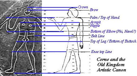
Cerne's feet point sideways while his shoulders point forwards, and in this respect his image conforms to the Egyptian artistic rules, but he conforms in more ways than this. Below here we see how he matches up to the canon of measures that was used in depictions of human figures during the Old Kingdom in Egypt. Adherence to this canon was fairly universal in Egyptian art.
So those are the seven mysteries relevant to the theory here outlined. Of course there are other mysteries linked to the themes we have discussed – the Pharaoh simulacra seen in a reflection of one of the great stones of Avebury Henge by Robert Lamont (http://www.weirdwiltshire.co.uk/stones/221098.html), the geometry for the cross-section of the Great Pyramid found across a range of sites in Wiltshire, including, again, the Avebury Henge, by David Furlong (described in The Keys to the Temple), the observation that the Avebury Henge together with the circular chalk banks of nearby Windmill Hill and the sacred circle of the Sanctuary together replicate the Orion configuration and the orientation of the Thornborough henges, the ankh symbols found engraved on megalithic stones in Northwest Europe (The Mediterranean Race, Sergi), the fact that the Egyptologist-archaeologist Flinders Petrie examined the stones of the old well beside Glastonbury Tor and reckoned it to be Egyptian work, or even the mediumistic channeling of Joan Grant author of the novel Winged Pharaoh in the 1930's, which linked Avebury with Old Kingdom Egypt, and more besides – but we have plenty here to be going on with.
The Iberian Connection
Having now outlined these seven mysteries we can note certain commonalities: massiveness of scale, a proclivity for working with chalk, and suggested links with Egypt. Is the last of these three feasible?
Certainly it is possible – the Old Kingdom Egyptians had large ocean-going ships and there are records of king Sneferu of the 3rd Dynasty, father of the builder of the Great Pyramid, organizing expeditions to collect resources from distant lands across the seas. Britain had gold, as well as the tin needed to make bronze.
A step from mere possibility towards feasibility comes when we consider the Iberian connection. A large number of Egyptian artifacts have been found in the Iberian Peninsula (Spain and Portugal). Evans speaks of examples from the 3rd Dynasty, concurrent therefore with the British Early Bronze Age.
DNA evidence discussed by Stephen Oppenheimer in The Origins of the British tells us that it was probably also the Iberian Peninsula fairly early in the Bronze Age from which the language of the insular Celts came to Britain, carried by an elite. (No major population displacement took place, and the old idea that the Celts came from central Europe in the Iron Age doesn't match the DNA evidence at all.)
If we are now to see the origins of Celtic culture and language in Neolithic or Early Bronze Age Iberia, then we can probably say that the priests of this proto-Celtic elite – the blanket term for the priest of the Insular Celts being Druid – did indeed oversee the construction of British megalithic monuments of the Early Bronze Age, rather as the old English Antiquarians imagined, for the DNA 'clan' in question coincides well with the regions where we see such monuments. This recent DNA work also accords with the ideas of those linguists such as Professor John Rhys and Professor Morris Jones who noticed that Welsh and Irish contain syntax and pre-Indo-European idiom remnants "derived from a language allied to Egyptian and Berber tongues." (The Welsh People, Pr.M.Jones) With possible Egyptian-connected Iberian colonies co-existing with an elite from Iberia who took up position at the top of the cultural hierarchy in Britain, an Egypto-British connection starts to look less strange, and even such fringe ideas as interaction between Egyptian priests and Druids – if we are using that term for the priests of these proto-Celts – become entirely viable for consideration. Avebury, as I've said, was completed by people who had adopted the round barrow-building Beaker Culture, and this culture spread right down to the South of Spain and even to the North Coast of Africa, in northern Morocco (where there is even, as well as a Beaker settlement, a stone circle, at Msoura), hinting at an extensive potential trade network. Beaker burials have also been found at the other henge sites mentioned in this article, namely the Thornborough Complex, and Dorchester-on-Thames. The daggers of the Beaker People are also curiously similar to Egyptian examples, and due to their grave goods these people are thought of as having been a kind of aristocratic elite. Connections between kings in different lands are known to have been intimate from such early times, as letters between, for example, pharaohs and Mesopotamian and Hittite leaders show, and connections with Bronze Age Greek sites like Mycenae are known to have been equally strong.
The Pattern Emerges
First Steps
I can still remember the moments when I took the first steps along the path of what would turn out to be an amazing treasure hunt. I was contemplating Michel's "St Michael Line", Mystery 4 in our list. I didn't fully buy the attempted debunking by another giant of British landscape mysteries. I must admit however that the attempted debunking did cause me to approach the topic from new angles. Some of Michel's initial speculations about origins and purpose seemed to have been taken on as gospel by certain factions of the New Age fraternity, but I began to doubt the idea that the St Michael Line was initially plotted out along the course of a pre-existing stream of Earth energy. I felt more drawn to a humanist stance. "What a work is man!" says Thrice Greatest Hermes. Just because we detect an awesome numinous halo around an idea, it does not necessarily mean that it was not produced by the hands of humans. Great art and architecture teaches us this, and sacred geometry can have such an alchemical effect. And if the ancients were the founders of the alignment, were the Feng Shui/Earth acupuncture traditions of China really the best place to search for hints of the mindset of those ancients? The alignment itself still seemed genuinely intriguing, and Michel's original intuition still drew me, but intuition doesn't always deal in exactness; it guides us along the way. So though I myself, like many others, could feel the intuitive draw of the St Michael's Line concept, I felt it was time for a fresh approach.
One of the theories about the St Michael Line is that it aligns to the Cross-Quarter Day Sunrise, during May and August. Like the stream of Earth energy theory, this sunrise alignment theory seemed like one to drop lower down the list of possibilities. The line ranges across latitude as well as longitude, so sunrise angles are different along the line, and why cross-quarter day anyway? I felt that it was Michel's observation that the line goes approximately from the most easterly to westerly points that put us on a sound footing for further investigation. But this simple geodetic aspect itself wouldn't have been enough on its own to inspire vast construction projects. It must have coincided with something else, some dovetailing that caused the ancients to think of the line as a manifestation of cosmic order, the quality the Egyptians called Ma'at. If it wasn't an alignment on a particular sunrise, what was it? Cultures that understood the perennial philosophy had a feel for the way that intelligible, ordered, mathematically harmonious ideas resonate with a realm beyond the world of change, flux and chaos. The architects of the Greeks, Egyptians and other cultures had a feel for this Hermetic-Platonic wisdom. With the cardinal directions giving the reference, an alignment would thus ideally follow a bearing that has some geometric intelligibility. Had anyone considered this geodetic line in terms of Sacred Geometry? I was about to make the initial discovery which set me on the path towards all that has followed.
The angle in question is quoted as 27'. I realized this is close to the 26.6' diagonal angle (or more accurately 26.56) of the 2 by 1 rectangle that has been a favorite in Egypt, Greece, Rome and the Renaissance, after Vitruvius was rediscovered. Indeed, it is known as the Vitruvian Rectangle. The floor plan of the King's Chamber in the Great Pyramid is an East-West aligned 2 by 1 rectangle, and this 26.6 degree angle is also the inclination angle of the Great Pyramid's passages, and further to this R.Cook, as detailed in an appendix of The Orion Mystery, has found key alignments at this same angle north of East in the Giza ground-plan.
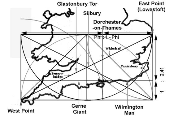
So I posed a question: if I measured at this exact bearing from Glastonbury Tor, the feature that is basically natural and, though sculpted, essential unmovable, where would it take me? Would it still pass through the Avebury Complex, would it still pass near the Dorchester-on-Thames complex, and would it still end up near East Point?
The result was very satisfying indeed. Not only did the 2 by 1 bearing lead to the Avebury Complex, but it went exactly through Silbury Hill itself, which has the more obvious analogous resonance with the Tor, as can be seen from the image below.

In the above image, only the tower has been digitally removed. The Tor is otherwise un-altered – the flat top is genuine. This shape is not a natural formation, especial given the similarity to the man-made Silbury, to which it is placed in exact Vitruvian relation with respect to the cardinal directions.
Michel's 27' degree line had in fact passed a few miles to the north of the Dorchester complex, but this 2 by 1 bearing went straight through it. It also took in the Whiteleaf Cross and Barrows site in Bucks on the Ridgeway, and I was very pleased to note also that now it did not just go to an "approximate" most westerly point several miles to the north of West Point in Lowestoft, but it actually went to Lowestoft itself.
There is some clarification needed when we talk about the bearing of this line. With mapping, there is always the question of how to transpose from the curved surface of a sphere to a flat, two-dimensional map. The resulting Euclidian (flat geometry) world is therefore a conceptual, virtual world (call it Mapworld) but is one that accords with our experience of the landscape as being based on a flat surface. As the ancient geographer Ptolemy wrote, the intellect is able easily to transfer the shape and size seen by the sight on a planar surface to the curved and spherical surface, and, we might add, visa versa. When we look at something like our straight line from East Point to (roughly) West Point going through Glastonbury Tor and Silbury, this is a straight line on the landscape, in other words an extended line-of-sight, as the crow flies, as they say, as can be measured on Google Earth. Altitude variations aside, it follows the shortest route between points. Approximating the globe to a sphere, if extended it would go all the way around the World and return to the starting point. Such a full circle of the globe has the same radius as the Earth and is called a Great Circle. There are also types of map projection where the straightness of this type of line is quite well preserved over certain ranges of longitude. Our line can be very easily followed on a British road atlas, for example, where it remains dead straight. It is so easy to follow because it runs parallel to a line drawn diagonally across rectangles on the road atlas one grid square tall and two grid squares wide. In your own time you may like to repeat the process I have carried out, drawing this straight 2 by 1 line from page to page on a road atlas, going right through Glastonbury Tor and Silbury Hill, to Dorchester, and ending up in Lowestoft, always remaining parallel to the 2 by 1 rectangle diagonals on the atlas.
The preservation of the straightness of the line has to do with the type of map projection used in this type of atlas, but what about the 2 by 1 business? On the landscape, rather than the atlas, through dead straight, the line is not a constant bearing with respect to the cardinal directions along its length, because the line changes latitude, and straight lines of sight do not maintain a constant bearing with respect to the cardinal directions at different latitudes. We do, however, find the 2 by 1 aspect showing up in other ways. The distance travelling between the East Point longitude and the West Point longitude at the more southerly latitude is close to being twice the distance travelling north from the more southerly to the more northerly latitude. This can be discovered quite easily using Google Earth’s distance measuring tool. But the Ancient Egyptians didn’t have Google Earth, so in what manner might the ancient surveyors have been aware of this 2 by 1 aspect? Having set out the straight line of sight on the landscape they could have measured the bearing at the centre of the line. To save having to go there, we can use Google Earth to work this out, where they would have used the stars on site. The bearing of the line at its central longitude (i.e. just outside Devises, Wiltshire) comes out as 26.8° (63.2° from North), which compares closely to the diagonal angle of a 2 by 1 rectangle, 26.6°. This is the bearing we find when drawing the line on a road atlas, all along the line, and there is a reason for this.
The AA motorist’s atlas uses the same coordinate system as the Ordnance Survey maps i.e., according to the OS website, ‘a type of projection known as the Transverse Mercator (TM).’ This is not the same as the normal Mercator. The normal Mercator Projection is one where all longitude and latitude lines are made to be straight, parallel / intersecting at right angles, so that a line of constant bearing shows up as a straight line on the map, but a straight line-of-sight/great circle shows as curved. With the TM however, such as on the OS maps, a line of constant bearing shows as curved, but, over areas not exceeding a few degrees in longitude, a line of sight (such as our line through Glastonbury, Silbury, Dorchester and East Point) will appear pretty straight, while the apparent bearing of that line with respect to the cardinal directions may be misleading. A TM projection uses a central meridian, and the angular bearings of direction on the map are only completely true at sites along that meridian of longitude. It so happens that the O.S. maps use a central meridian quite precisely at half way between British East Point and West Point, 2° West, and this is why the angle on the road atlas is the same all the way along the line we are dealing with as the true bearing of that line at the central longitude! I’m not suggesting, of course, that the ancient Egyptian surveyors were using a Transverse Mercator projection, but it is reasonable to picture them assigning a value of the bearing at this central longitude to the line as a variable of some significance; they might well have seen this as the angle of the line within their flattened Euclidian Mapworld conception. After all, why would you use the bearing at far west and east extremes, when these are also at the extremes of distortion? If you had to pick one angle, you’d pick the one at the middle. Using the central longitude seems sensible, and logical, and this after all is why 2° West was chosen as the longitude of the central meridian of the O.S. maps. In this virtual world, the British Mapworld, the Glast./Silb./Dorch./E.P. line really is the diagonal of a 2 by 1 rectangle, and as such the foundation of a geodetic scheme based on Sacred Geometry.
Encouraged by this, I did some further reasoning. This alignment was now looking like one based on Sacred Geometry. The reason why the 2 by 1 rectangle has been a favourite for geometers down through the millennia is that the diagonal minus the short side is the Golden Ratio – that perennially intriguing, harmonious, mystical proportion – of the long side of the rectangle. The short side length can be swung as an arc using compasses to the diagonal, and the longer length marked off on this diagonal, (the remainder of it) can then be swung down to the long side at its Golden Section.
Now the long side is divided into two lengths, and the ratio of the shorter of these to the longer is the same as the ratio of the longer to the sum of the two. This is the Golden Ratio, in which, as with political systems where ma'at or eunomy is present – the effective running of the polis made up of individuals – as with such systems the relationship of the parts is found by factoring in the whole of which they are parts. It is a proportion that has repeatedly been found to be aesthetically pleasing, and it is still used widely today. Since it is this that makes the 2 by 1 rectangle so interesting to the Hermetic-Platonic artist and architect, I reasoned that I would expect to find something of significance at the Golden Section of the line in question. I had to now use a different name for the line. I couldn't call it the St Michael Line anymore; I wanted as far as possible to leave that line alone, allowing it its own existence whether as a new or old idea, and to treat this 2 by 1 line as a different entity. I toyed with long names like the Foundational Vitruvian Hypotenuse, but the Golden Diagonal will suffice. So I was after the Golden Section point along the Golden Diagonal.


Marking off the Golden Section of the long side of a 2 by 1 rectangle using the length of the diagonal minus the short side. Right: this same geometry in use in an Egyptian depiction of the Spirit Double of an Official standing in a 2 by 1 'False' Door, with the geometry superimposed. (Various researchers, such as, notably, Else Christie Evans in Geometry in Egyptian Art, have observed that the Golden Section is absolutely rife in Egyptian imagery.)
I had a map in front of me with the line marked along it. With a long ruler, I measured the full length, calculated the Golden Proportion of that, and then measured again to find that suitable spot for the Polis of Ma'at, for Eldorado, the City of Gold. Here was the first revelation. No matter how many times I measured it, the Golden Section of the 2 by 1 diagonal from West Point to East Point through Glastonbury Tor exactly pinpointed the most significant archaeological site in the whole of the Thames Valley, a complex of sites once including an enormous double henge with cursus. It was, of course, that Dorchester-on-Thames site that we have spoken of already.
I began to feel exited. Very exited. I visited Dorchester-on-Thames. Repeatedly. I coined a name for the scheme: Angleland. I even had a vision while lying in bed of a great vortex of light rising from the Dorchester site up into the skies. I felt I had something. Dorchester-on-Thames was a very important centre, perhaps even a royal capital, for thousands of years. There is even an old Welsh story in The Mabinogion – Lludd and Llevelys – that describes how in order to end a fight between two dragons that had been plaguing the land, a measurement of the width and breath of the country was made, with consultation from the king's brother in Gaul, resulting in the pin-pointing of a site in the region of Oxford, and then a beaker of golden mead was buried as part of the healing rite. Oxford is a short way upstream from Dorchester, and in ancient times it was the latter that was the big centre. The place where the mead was buried became known as Dinas Emrys, according to the story, the Fort of Ambrosius, although perhaps it makes more sense that Emrys comes not from the male name Ambrosius but from "ambrosia" in reference to the honey mead, because the story says that it was from the time of the burying of the honey mead onwards that it took this name. (These thoughts of the Fort of the Honey Mead might lead us to the talk in the Taliesin poetry of the Castle of the Honey Mead, but let's not get distracted.) Dinas Emrys is associated with the fight between the two dragons not only in The Mabinogion but also in Geoffrey of Monmouth, but there it has become associated with the Mount Snowdon region. This would be strange – why bury the mead at Mound Snowdon in Wales if the place located by the measurement of the land was near Oxford? A solution presents itself when we consider the Dorchester-on-Thames location. There are two distinctive and well-known prominences in this location called the Sinodun Hills, crowned by those famous copses painting by Nash, the Whittenham Clumps. "Snowdon" could hardly be more similar to "Sinodun", and on one of these two hills, Castle Hill by name, there are to this day the earthen ditches of an ancient hill-fort. This, I suggest, is Dinas Emrys, the Fort of Ambrosia, and this is where the beaker of ambrosia was buried. I've already mentioned that Dorchester is a Beaker Burial site. As an intriguing footnote to the Lludd story, I might mention that The Mabinogion says that before this site was called the Fort of Emrys it was previously known as the fort of a noble youth named Ffaraon Dandde, translated as "Flaming Pharaoh".
I should contact Michel, it seemed to me. A few positive words from him and I could entice publishers to help me share this scheme by means of a published book. Thousands of readers would result in a strengthening of the Morphic Fields of this geometric idea of place, grounding it into the landscape, and thus collectively we could awaken the Albion Osiris, I reasoned, and dreamed of how we could thus activate the foundation of a eunomous High Culture, a New Renaissance or High Civilization of ma'at with its glorious shining capital at Dorecester, The Golden Castle, complete with dreaming spires, Isis statues (this is the spot where the Thames becomes the Isis), Vitruvian temples and Hermetic academies!
But from my written correspondence with Michel it became clear that he didn't want to abandon his St Michael's Line with its 27' bearing. He admitted that "the 26.6' angle is interesting", appreciated the spirit in which I was working, and complemented the attractiveness of presentation, but there was not the emphatic backing of the 2 by 1 angle I'd hoped for. His reaction was understandable: he was now used to defending the Line against all comers.

I pushed on with my investigations. Once I had received this encouragement (from the Dorchester surprise) for the notion that the 2 by 1 alignment was important because of the relation of that rectangle to Sacred Geometry, I had to ask myself the question of how the 2 by 1 rectangle is itself generated by geometric means using compass and straight edge. The answer is through the simple Vesica Pisces pattern, the most elementary generative pattern in Sacred Geometry – generative in the sense that many other forms can be arrived at from this. Having realized this, it next made sense to have a look at how the pattern related to the landscape. One of the two all important intersection points of the Vesica pattern turned out to be on dry land, and intriguingly it pinpointed a sacred site of Piscean pilgrimage even more important in its day than Glastonbury, the greatest of all Britain's pilgrimage centers during the Christian period, namely Canterbury.
Of course, I had to pay a visit. Not being a Christian, I was surprised by how beautiful, satisfying and harmonious I found the vision of the great cathedral of Canterbury, the experience reminding me of the feeling I had when visiting the Athenian Pathenon, and with all those gothic arches it is, appropriately enough, a veritable temple of the Vesica Pisces. Considered architecturally, the religion of the cathedrals can seem to be its opposite, a celebration of the generative goddess, and nowhere more so than at the great temple of Cunnit-Borough. The Gothic Arch is a British innovation, a fulfillment here of the need in architecture for some vernacular element, being first employed in, if I remember correctly, Durham. I even found some arches in the Canterbury temple carved in relief that made the link to this pattern of overlapping circles explicit, as my photo here shows.

The Cantebury Tales of Chaucer mark the beginning of the diffusion of the Renaissance into England, and here is a geometric foundation worthy of Hermes Trismegistus himself, right on the site of what was previously a classical Roman city complete with temples and amphitheatres, baths, mosaics and the lot. If Canterbury's integration with the sacred geodetic 2 by 1 rectangle was just a coincidence then it was a wonderful and elegant one.
But the Christian period is tangential to our investigation here, and these were still the first steps along the path of discovery.
The Two Giants
While I was considering these matters, I read a book called The Keys to the Temple by David Furlong (http://www.kch42.dial.pipex.com/keys_intro.htm ). If you follow the link you will see that the climax of his work was what appears to be a reference through an arrangement of sites in Wiltshire to the cross-section geometry of the Great Pyramid of Khufu. In addition, the St Michael Alignment forms a basis for the pattern, and Furlong also reveals a method for creating this pyramid cross-section triangle from the Vesica Pisces pattern, which by extension integrates it also with the 2 by 1 rectangle. With the obvious contextual links to my own work, as well as the geometric links, I wondered whether it would be worth inserting the pyramid cross-section into the great 2 by 1 rectangle I had arrived at, to see what would be located at the position of the all important King's Chamber.

What I discovered blew my socks off. In the cross section of the pyramid a shaft extends up from the King's Chamber which aligned upon the culmination of Orion's Belt in the Pyramid Age. I discovered that right at the end of this shaft on the map, just where it levels out to enter the King's Chamber, is an image of that same constellation, Orion, carved into the chalk, namely the Cerne Abbas Giant. I've appended at the end of this piece some longitude and latitude calculations to show just how accurate this is.
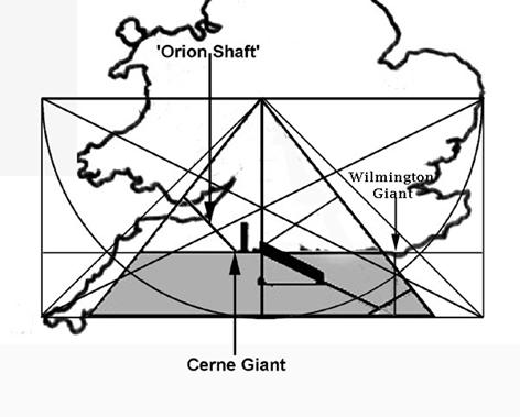
The Orion shaft points up at the southern sky, while the north face of the pyramid looks up towards the northern sky, the context appropriate to the Long Man standing at geometric point just outside the northern slope in the diagram. So for some reason the Master Builders chose the rotate the cross section diagram so that the south face is on the east side, and the north is on the west.
What on Earth had I uncovered? With its perfect context, the Orion of Cerne was a great deal more than I had expected to find from so quirky a notion as inserting the pyramid triangle onto the landscape within the 2 by 1 rectangle. I'll be honest, I was a bit shaken. I put the map down and went into town and headed for the nearest pub, deliberately thinking blokey thoughts in an attempt to stabilize my mind back into the familiar world. I drank a beer, and even contemplated playing a fruit machine. I looked over to the one that was in the pub. It's theme? Egypt, and the pyramids. Gasp! Clearly this thing was not something I could sweep under the carpet. I'd come too far down this path of discovery to turn back. I had to see it through. Was it just an astounding coincidence, or had the secrets of the Great Pyramid been encoded into the British landscape long ago as a kind of treasure map? The latter was of course possible, which entailed so much work by those ancients that it was inconceivable for me to ignore it and not bring it to light. All that planning, sweat, and effort, and as far as I knew I was the only person on Earth who knew about it…clearly I wasn't going to let them down.
As summer drew on I grew in courage and, feeling more like the Nicholas Cage character in National Treasure than the Tom Hanks character in The Da Vinci Code, I even paid Cerne Abbas a visit, finding the village to be idyllic.
It seems that this quirky discovery had raced me several steps forward all at once, giving me answers for questions I hadn't even posed, solutions to clues when I didn't even know what the clues were. It wasn't that I couldn't understand why they would have done this, it was simply that I couldn't quite figure out how I had managed to uncover it without even following a proper trail of clues. As far as the motivations behind the scheme are concerned we may consider a story that was written down in Egypt in the Middle Kingdom. According to this story the pharaoh Khufu was concerned to find the details of the Chambers of Thoth so that he could incorporate their configuration into the internal chambers of his "horizon", the Great Pyramid. Clearly this configuration was felt to have some talismanic power, and it was probably this same power which the surveyor officials set about invoking in Britain by means of a grand geodetic scheme.
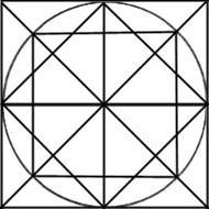
But as we turn our attention to the other chalk giant, the Long Man, we can approach the matter by a more gradual, steady and well-reasoned series of steps. We have already seen that this other chalk giant with his two staffs looks a great deal like Egyptian images which relate to the Balance of the Two Lands. In my piece The Balance of the Two Lands: Ancient Egypt's Division According to the Ratio of Triangular Equilibrium here on the Graham Hancock Forum site I have described how the city of Memphis was said to be located at this place of balance, and how in fact this balance between the lands of Upper and Lower Egypt is in fact a latitude measured off at a certain ratio of the latitude covered by the distance southward from the North Point on the Egyptian coast down to the Primordial Mountain at Thebes. I wrote how "The ratio in question is derived from a process of halving the area of the square using diagonals and a circle, as shown here…This 1 : 3.41 ratio can truly be called a sacred geometric constant because, for example, it is the relative height of the horizontal that divides the areas of all isosceles triangles in half."

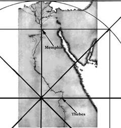
The ratio is expressed at 1 : 3.41 where the 3.41 is the whole length, or as 1: 2.41 where the 2.41 is the longer of the two lengths. I also noted that "The inner square is half the area of the outer, so that this diagram shows the Great Pyramid from above, where the inner square represents the level on which the King's Chamber is placed but shown on the outer surface of the pyramid." The image below of the pyramid seen from above also expresses this, and the one next to it is a proof that the inner square has half the area of the outer.

So if the Long Man represents the Balance of the Lands in the British geodetic scheme, surely that means that he stands at a latitude that similarly expresses this 1 : 2.41 ratio, existing within the foundational 2 by 1 rectangle of the scheme. This is very easily and clearly shown, as in the diagram below.

And we can recap by putting in more of the sites we have so far discussed in this second, rather more busy diagram.
Suffice it to say that these are the more logical steps that I had skipped by going straight to the Cerne Abbas shock, but now we can see more logically why we might try putting in the Pyramid Cross-Section Triangle.
The Yorkshire Exaltation
My thoughts began to turn to Thornborough. Like Cerne Abbas, it seemed to have an Orion association, a Beaker Culture presence was in evidence, and the henges with cursuses were so obviously built by the same people who had put their mark at the Golden City, the Dorchester-on-Thames Complex so integral to the "Angleland" scheme. There was, furthermore, the implicit Egyptianesque aspect, the Giza link. Could it relate in some way to this British Pyramid Plan?
But so far I had only been looking at a 2 by 1 rectangle covering the South of England and Wales. Thornborough was way up in North Yorkshire. How could it be part of the same scheme?
Scanning the map for some kind of pattern, I noticed a similarity between the locations of Thornborough and Cerne Abbas, the two Orion associated sites. From the apex of the Pyramid Plan (at, of all places, West Bromwich in the Midlands). Thornborough looked to me by sight to be the same distance north and east of this apex as Cerne was south and west. What might this indicate, I wondered?
A particular way of thinking had brought me thus far, and the best I could do was to stay true to it. This line of thinking had been based on the assumption that the Master Builders behind this scheme, the surveyor officials, found that they could ascend out of Time into Eternity by working according to intelligible ideas. In other words if I worked in a similar way, going for order, balance, regularity…ma'at, in other words, I could rediscover the trail they left behind. For the geometer looking at the scheme as it so far existed on my maps and diagrams, there is an obvious ordered way of extending it northwards. A 2 by 1 rectangle contains, as we have seen, Golden Proportions, but of itself it is not as regular as it could be, because it has one short side and one long side. It is not as regular as, it does not have so obvious a centre as, the square. The apex of the pyramid triangle is located half way along the northern long side of this rectangle, and were a similar 2 by 1 rectangle to be added to the north, this apex point would be right in the centre of a square. I then noticed that the northern border of the extended scheme was now loosely marked by the meandering course of the old, traditional border between Britannia and Scotland, namely Hadrian's Wall. Hadrian himself was a master builder, and "very expert at geometry", according to his contemporaries, and his first priority when arriving in Egypt was to converse at length with the scholars of the Alexandrian library, and he's is also described consulting the Delphic and Theban oracles. He lived in Britain for about a year.
However, I wasn't about to get too sidetracked away from the Bronze Age period with speculations about Roman knowledge of the old scheme, any more than I had been with the Canterbury Coincidence. The point to retain in my mind, I felt, was the possibility that the old Bronze Age Master Builders had themselves extended the scheme to make a square, and all I was really prepared to take away from the Hadrianic considerations was a new conviction to refer to the plan as the Britannia Scheme rather than the rather Anglo-centric "Angleland", thus embracing Wales within its compass.
So if a closer measurement revealed that Thornborough did have the equivalence to Cerne Abbas with respect to the apex/centre, the question would be why, and I preferred to consider what this might be before I troubled myself with the measurement. The answer was pretty obvious – if the centre was kept as the apex, and a similar pyramid cross-section was placed in the northern rectangle, Thornborough would be perfectly placed at the end of the Orion Shaft.
This wouldn't be as flaky as it might have sounded, as for the Egyptians it was not North that was up, but rather simply upstream that was up. In Egypt this meant that Lower Egypt was down in the lowlands of the Delta to the North, and Upper Egypt was upstream in the South. In Britain all rivers flow from inland regions down to the coast, on all sides, so to the Ancient Egyptians it would be the centre of the nation that was the top, not North or South specifically. What to us seems like an inverted pyramid, with all those Freemasonic, Dan Bownish connotations, would not have seemed upside-down to that ancient mindset.
It was pretty clear what needed to be done. It was time to make the more accurate measurement. It wouldn't be so hard to count the grid squares on an Atlas of Britain, going from page to page get a figure for the position of Cerne Abbas west and south of the apex/centre. Then all I had to do was go north and east the same distance and see if that's were the Thornborough Henges were.
I was sprawled on the floor of the place I lived at the time, my flat in Marlow, by the Thames, with the Atlas in front of me. Anticipation fluttered inside me as I counted north: one, two, three…how amazing would it be if it turned out to be true? Twelve, thirteen, fourteen…could the scheme put in place so long ago really be so vast, elegant and comprehensive? Seventeen, eighteen, nineteen…if so, how amazing that enough information was available to make this much of it re-discoverable! Twenty, twenty-one, twenty-two…was this just the perfect sleuther quest for me, or what?….
Having counted off the number of squares north I began to sidle laterally. …three, four five…I homed in on that fateful destination, that grid-square of destiny…until my finger pinpointed the spot.
And there before me was the village name I had hoped against hope to see…
Thornborough
I cannot adequately describe the feeling that then ran through me. A lofty thrill, exalted, lifted my mind's eye as if on the very falcon's wings of Horus, as I fell forwards onto the floor, my face and palms pressed against the light, polished oak-wood floorboards, as I did my best to stay grounded and on-planet. Oh my word!

"It's all too much!"
(The Pepperland Pyramid)
Link to It's All Too Much on YouTube : http://www.youtube.com/watch?v=y278uc1J3o8&NR=1
So much was suddenly confirmed beyond reasonable doubt, a light shining back along the path I had followed, as well as out along the old geometric paths of Britannia, all the way up to Thornborough. Thornborough was part of the scheme. It is Orion's Belt. So too, logically, is Cerne's Man Orion. Dorchester is the Golden City. The Egyptians did come here. Silbury is a Primordial Mound. There probably was a Silbury Oracle Center. It was placed deliberately at the 2 by 1 bearing from Glastonbury Tor. And somewhere, surely, is a National Treasure, a pharaoh's hoard! And did those feet in ancient times…? Yes – Oziris woz 'ere!

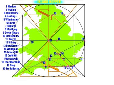
Image taken from my short story Island-Hopper : Ge-Odyssey
The long straight cursus leading from the northern Thornborough henge to the central henge measures up, from the Google satellite picture, as being at the same 45 degree angle of the Orion Shaft, in other words precisely South-East, and so this long straight avenue represents perfectly the Orion Shaft itself on the plan.
Getting it Out There
I had by now become fired up with a desire to share this discovery. I felt it was too magnificent to be appreciated just by myself, so I sent off a few synopses and sample sections. The boss of a small Wessex-based publisher seemed interested, and she invited me down to her cottage for a chat. Excited, I set off, but within twenty minutes of our chat in her living room it had become clear that she wanted me to come up with the money to finance the first print run. Vanity publishing. Poo! She knew John Michel, but I knew he'd already seen the theory, albeit in an earlier form.
A Glastonbury-based publisher well-known in Earth Mysteries circles was also interested, but, they said, unfortunately alignment-based mysteries weren't selling well since Devereux's about face. But then a reply came in from Chris Street, author of the Earthstars books about the Sacred Geometry of London. John Michel wrote the forward for Chris's book, and now Chris was keen to write the forward for mine – there was at least a kind of lineage.
"Yes, please, go ahead," I replied. His critique could not have been more enthusiastic: "…astonishing and undisputable….The geometric evidence on the landscape is irrefutable as are the Egyptian connections. The implications may seem unbelievable but the evidence presented appears very well researched and honest." He did however include the words "despite the terrible pun", referring to my title, Angleland. Hmm…maybe he had a point.
I got back in touch with the Glastonbury-based publisher to tell them about this new development. "We love Christ Street's work," they said. "OK, next time we see John Michel we'll show your book to him and see what he says. If he likes it we'll publish."
But of course, as I noted above, I already knew Michel's position on this, and certainly I didn't hear any more.
Next up was a smaller publisher based near Burrowbridge Mump. They were intrigued by my synopsis. No, they weren't in a position to publish at that time, but could I please send the rest of the book anyway because they were personally very interested. Ruddy cheek!
Next it occurred to me I really ought to send the theory to someone intimately involved with the Egyptian Orion Mystery, as this after all was the at core of my discovery. I sent the theory to Mr O.C.T. (Orion Correlation Theory), Robert Bauval, who at that time lived just a few miles from Marlow, in Beaconsfield. He had the graciousness to phone my home personally. I didn't gather how much of it he had found time to read, and he was busy downloading photos for the book he had on the go at the time while he spoke to me (Talisman, I think it must have been), but he did have an offer for me: "I'm a good friend of John Michel; I'll show it to him if you like."
I muttered some kind of reply, and my gratitude was genuine, but of course, unbeknownst to Robert, this kind of got me back to square one, so I didn't prompt him to follow up that generous offer. John Michel must be a sociable and popular fellow, I reasoned, to be friends with pretty much everyone I had so far contacted.
Then came another shining knight, in the form of John Billingsley, editor of the archaeological journal Northern Earth. Like me, he thought the debunking of the St Michael's Line went too far, and he was interested in this new take on it that gives it fresh life, and he also felt a particular connection to the Dorchester-on-Thames site. At last I got a summary of the scheme published in his journal – a short, condensed article with the Long Man as the theme of the title, that never the less outlined most of the key points. A weight lifted off my shoulders, but I still wanted to go much further with this, to reach a wider audience, get a book published…even one day a TV documentary or DVD….
When an opportunity arose to bring to a wider audience an article focused solely on the Egyptian version of the scheme, the Balance of Lands, here on the Graham Hancock website Forum it was definitely another step in the right direction, especially as Bauval's friend Adriano Forgioni then wanted to publish an Italian translation of it in his widely read magazine HERA. And the piece you are reading is the next step along this path!
The Great King
The grand landscape project here outlined cannot be the result of a gradual cultural diffusion, because it involves insider knowledge of the chambers of Khufu's Pyramid. On the other hand the lack of artifacts inscribed with Egyptian hieroglyphs implies that it was not a project of pure Egyptian colonialism. Then again, the notion of a small Egyptian contingency staying for a while and organizing local workforces also seems unlikely, because there could have been no guarantee that such organization could be achieved at a range of sites as far apart as Cerne Abbas and Thornborough, for jobs as major as the construction of Silbury and the great henges. The plan involves east-west distances, not just the latitudes that are relatively easy to measure from Sun or star inclinations. Establishing the scheme would have entailed a project of landscape triangulation that must have taken a long time.
This leaves us, as far as I can see, with a scenario in which the project as a whole is actualized with the support of a great king whose authority is recognized across the land, and who has in his employ certain Egyptian surveyor officials, including a Master of the King's Works figure who himself has a strong Egyptian connection, perhaps through filial Iberio-proto-Celtic Beaker Culture links. We may call this great king, for convenience, Arthur. For historical comparison in thinking of his vizier and surveyor officials we could think of traveling builders' guilds through the ages and of the itinerant classical scholar of the Italian Renaissance who moved from court to court diffusing by direct contact the ideas he had learned in, for example, the Florentine Platonic Academy, as he found his way through the networks of Upper Class Europe. The myth of Osiris as recorded by Plutarch says that after this king of the Golden Age had established harmony in Egypt by a plan of temple building with the assistance of his divine scribe Thoth, he then traveled to other lands to continue this work. Did the Old Kingdom Egyptians carry their sacred geodesy and the idea of ma'at abroad just as the myth says, even winning as one of their converts the High King of the White Island on the Ocean, rather as later Rome would by sending a missionary (St Augustine of Canterbury) win over to their Christianity as their first Anglo-Saxon convert Aethelbert, whose capital was at Canterbury?
The Riddle
Working with the geodetic scheme outlined above, you may be lead by the following clue to Paul Devereux's belly button. Email solutions, with reasoning, to [email protected]. I'll let you know if you're the first to find the spot. The site is not mentioned in the above article.
At first this Universal frame
From harmony began
And from Vitruvius Da Vinci learned
The perfect square of Man.
With head to East the giant lies
And arms stretched 'cross the land
Leonardo's drawing shows
The secret of the span
There is a hill upon a plain
Find it if you can
A place of golden harmony
The umbilicus of Bran
Two Poems
For me, the existence of this geodetic scheme is a reality. I realize that this could then lead to questions of the finer details of the surveying techniques that were used. However, we might just as easily choose to go at this point in a different direction, away from the technical and towards the poetic and the mystical.
You may find two poems inspired by the scheme on my blog at TWO POEMS
Appendix: Calculation of Pyramid-Related Positions
I haven't mentioned that in my eagerness for this Hermetic landscape scheme to become activated by its reaching a large audience I spent a summer writing up the above theory as a Da Vinci Code-style novel, calling it Arthur's Ark, and giving myself a more concise pen name to boot. Well, to my embarrassment, I did this, but I never had the courage to do much with it, which may be for the best. But by extracting the location calculations from that text it may at least make them seem a little (just a little) less dry. The characters, who we join here well into their quest, are first concerned with proving the halving-of the square method, then moving on to the important latitude and longitudes of the giants. Again, you can find this on my blog at Appendix: Calculation of Pyramid-Related Positions
I have also written a short story based on this geodetic scheme, but don't read it if you don't want the game to be given away re the Riddle. It can be found at: http://cuppalot.blogspot.com/2007/06/island-hopper-geodesy.html while other whimsical offerings on the same basic theme can be found from this link to my other blog: http://jangleland.blogspot.com/2007/09/chronology-of-jangleland-pharaohs.html