


It is our pleasure to welcome Freddy Silva, author of Scotland’s Hidden Sacred Past, as our featured author for January. Freddy’s book investigates the enigmatic stone circles of the Orkney Islands, exploring the Armenian and Sardinian roots of Scotland’s Neolithic civilization. In his article, Freddy examines the mystery behind the creators of these ancient megaliths, shining a spotlight on their archaeo-astronomical connections with the constellation of Orion and other ancient sites around the world.
Interact with Freddy on or AoM Forum here.
A LITTLE SOUTH AND EAST OF ORKNEY
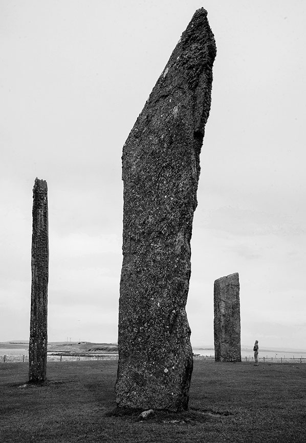
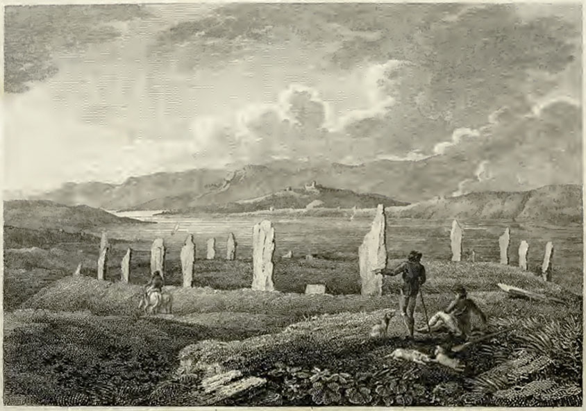
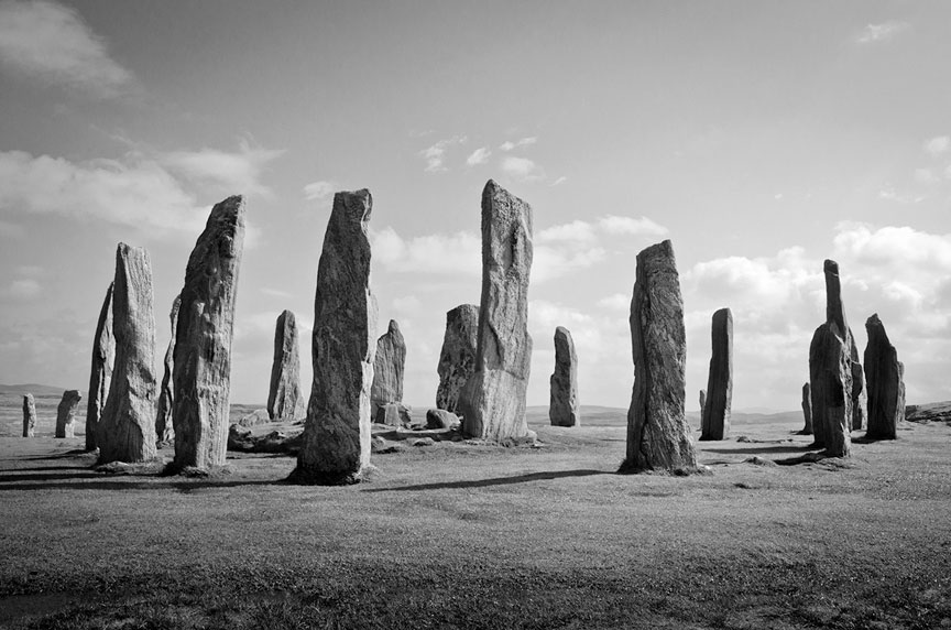
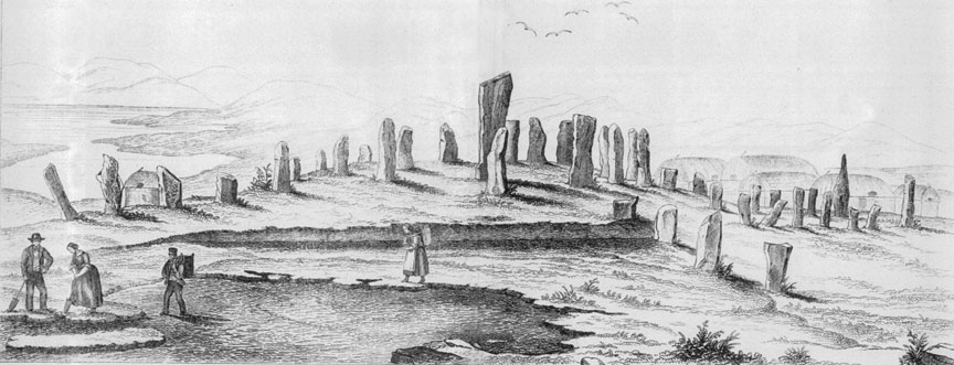
The remaining yet still impressive stones of Stenness.
Around 5300 BC a revolution occurred on Orkney. A group of unnamed seafaring astronomers dared to sail across one of the most hostile waterways in the world to establish the earliest stone circles in the British Isles, along with unusual conical towers and horned passage mounds. Such architecture had no parallel in Britain and had more in common with regions around the Caspian Sea and the Mediterranean.
When Scandinavian settlers arrived in Orkney they recorded how the builders of this megalithic culture were physically different from locals, spoke a different language, wore white tunics and behaved like a priestly caste, they formed a society apart. They had long vanished, all that remained were their names: Papae and Peti.
The origins of these mysterious people and the monuments they left behind, from Orkney to the Hebrides and into Ireland, aroused my curiosity for years, leading to the publication of my research in Scotland’s Hidden Sacred Past. What follows is a précis.
Three stone circles form the axis mundi of Neolithic Orkney. The first, Stenness, is perhaps the most impressive despite only three-and-a-half of its eleven original monoliths remaining. Unlike others of its kind, Stenness looks and feels like a machine or a place of high council rather than an object with which to measure the sky, and it was still remembered as such before the town of Kirkwall took over the role. While looking through the notes of Joseph Banks’ expedition of 1772, I came across a watercolour of a nearby monument that has escaped everyone’s attention. In the foreground, a man sits on a broken stone drawing two megaliths, while a further six stones as tall as Stenness stand behind him. There’s no mistaking the position and orientation of the illustrator, he is on high ground, with Stenness itself positioned in the background with the loch beyond. Between the watercolour and the accompanying survey, one is given the impression of a quadrangular stone monument, and if so, the design seems consistent with similar enclosures such as Crucuno in Carnac, Avebury in England, and Xerez in Portugal, all of which were designed to calculate the extreme rising and settings of the Sun and Moon.

Miller’s watercolour of 1772 of a missing quadrangle of stones. Stenness is in the background
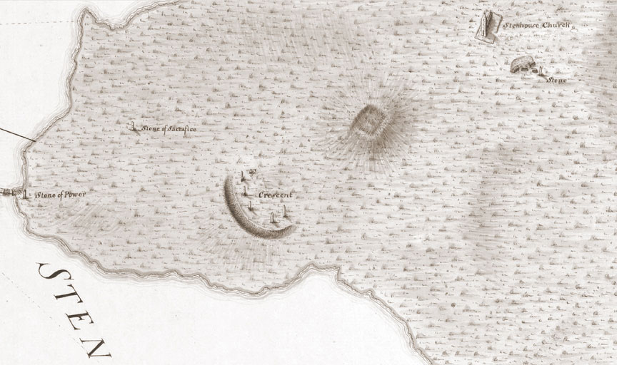
Walden’s survey of the area around Stenness clearly shows a rectangular mound, now missing
Along the narrow isthmus to the northwest of Stenness stands a more intact Ring of Brodgar, twenty-seven of its original fifty-six sandstones are still upright (the number required to calibrate the solar and lunar cycles, just as with the Aubrey Holes around Stonehenge). The circle and its 12-foot deep circular ditch were not placed on the high point of the ridge, as expected, but precisely where the 59th degree of latitude runs through the center.
19th century view of Brodgar
Further along the ridge, there’s a third circle, the Ring of Bookan, occupying the high ground from where it is possible to see the other two sites. All that remains of Bookan is a central mound with a collapsed chamber and a circular ditch filled with soil. However, when Frederick Thomas visited the site in 1848 he clearly mentions stones buried around the perimeter, since scavenged for building material; three are still employed nearby as gate posts.
Little written information survives on this collection of circles, only folklore. As for age, the earliest C-14 dating of debris from the ditch at Brodgar is 3700 BC, but this only informs us when the site fell into disuse and began to silt. The general archaeological consensus is that Bookan itself was likely built c.4500 BC, fell into disuse by 2900 BC, and was thereafter monumentalized for the interment of human remains. When George Petrie assisted in the excavation of the site in 1861 he too was sceptical of Bookan having been originally used for burial, for a number of valid reasons, and that the orthostatic box he sketched inside the collapsed mound served a different purpose.
Since the ancients are known to have built many, if not all, sites according to the rules of sky-ground dualism — whereby the direction or layout of a monument memorializes an important moment in the sky and transfixes it on the ground — I decided to look into the alignment of the three stone circles and see if an archaeo-astronomical date could be established.
The axis of Bookan, Brodgar and Stenness follows a general south-easterly trajectory of 129 degrees, giving a potential correspondence to the winter solstice sunrise c.6800 BC. This was surprising because no one should have been building such structures this early and so far north, even though human activity here is radiocarbon-dated to c.6600 BC. But the three sites are not in perfect alignment – Stenness is askew from the others or seen in reverse, Bookan is off-kilter. Any alignment is therefore redundant, and the answer lies elsewhere. It was at this moment that a vivid snapshot of the belt stars of Orion presented itself in my mind. Could this be what the architects had intended? Between Bookan’s strategic vantage point, Petrie’s sketch of its orthostatic box (giving us a useful angle of alignment) and its line of sight pointing to a natural bowl along the horizon formed by the interweaving of natural landscape features, we are offered a site pointing to a hollow from which a celestial object is supposed to rise.
The typical markers for sky-ground temple relationships fall disproportionally on two specific times of the year: the winter solstice and the spring equinox. Tracking the sky back 8000 years revealed that the Sun and the chamber of Bookan were never designed to meet. The Moon, on the other hand, is referenced at its Major Standstill when it makes a brief appearance a few degrees above the horizon. But what of Orion?
As the program slowly rotated the heavens in the era of 6600 BC, Orion still lay below the horizon, so nothing doing there. Then on the evening of the winter solstice in 5300 BC, the three belt stars rise for the first time, cutting a narrow arc over the island of Hoy for a brief thirty minutes before sliding behind the hills. So this is what the light box at Bookan was looking at so long ago.
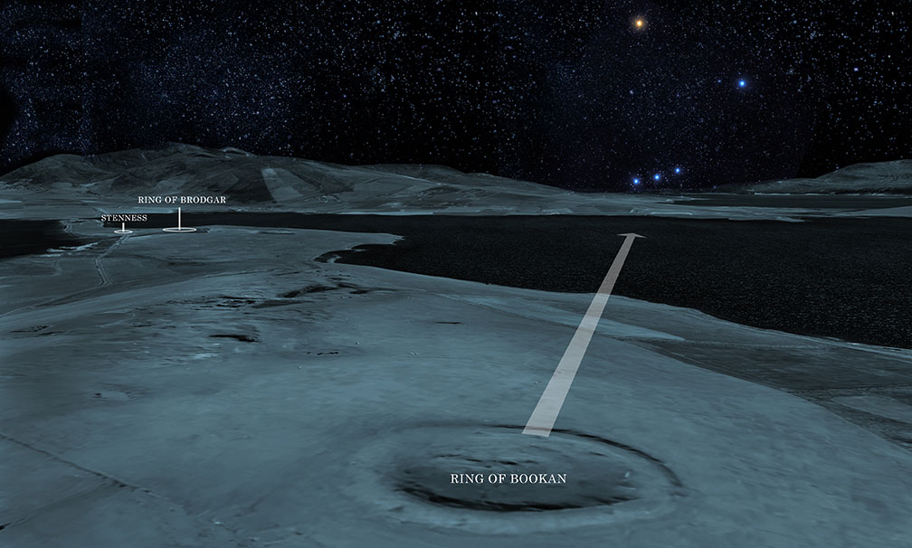
View from Bookan’s orthostatic box of the first rising of Orion, 5300 BC
But Orkney’s ancient architects had something more on their minds. The smaller of the three belt stars, Mintaka, is seen on the right. On the ground, the circle of Stenness is the smaller of the three and is therefore assumed to be that star’s terrestrial counterpart. Taking a bird’s eye view looking south, Orion’s Belt is seen mirrored in reverse by the three stone circles – a sky-ground relationship of which any ancient Egyptian would be proud. On a hunch, I overlaid an accurate survey of the three pyramids over the Orkney stone circles and was surprised to see the same spatial relationship is consistent between the two sites, right down to the tip of each pyramid referencing the centre of each circle.

Orkney’s three stone circles with the Giza pyramids superimposed
The Orkney archipelago has been called the Egypt of the North on account of the disproportionate number of Neolithic sacred sites – 3000 at last count – relative to its territory. The closest comparative example is Malta. Incidentally, a southward trajectory of 126 degrees through Brodgar and Stenness leads you directly to Giza.
Across the archipelago, one finds something truly alien to the region: horned passage mounds. The northernmost is Point of Cott, now partially devoured by rising seas, its orthostatic box more at home in Sardinia than Britain, its alignment matching the first rising of Orion’s Belt on the winter solstice c.5300 BC. To the east lies Head of Work, its chamber marking the equinox sunrise c.5000 BC. And finally the heavily weathered horned mound at Vestra Fiold, not far from where the stone for the circles was quarried. The dates make them contemporaries of the stone circles. Marked on an OS map the three form a perfect isosceles triangle. I couldn’t help bisecting the angles to see what might lie at the center. The exact crossing point occurs on the island of Ramsay, at the base of a steep hill marked by Knowe of Lairo, a 130-foot long-horned mound.
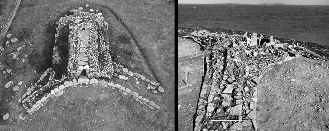
The original horned passage mound at Osono in Sardinia, and its later cousin on Orkney at Point of Cott. Both reference Orion.
It is quite an effort to position four remote objects accurately using GPS alone, but to do so without technology across 340 square miles of undulating terrain, over waterways and hills is impressive. Here we have a kind of flattened pyramid outlined across Orkney, and what’s more, both the perimeter of the triangle and the trajectories of its bisecting lines are marked by a plethora of sites: chambered mounds, brochs, and summits of hills presumably used by an ancient surveyor. The north-south line, for example, ends on the summit of Ward of Redland, the highest point of a range of hills and from where one gets an unobstructed view of three of the four mounds. The exact spot of the construction line and its trajectory is still marked to this day by ancient field boundaries.
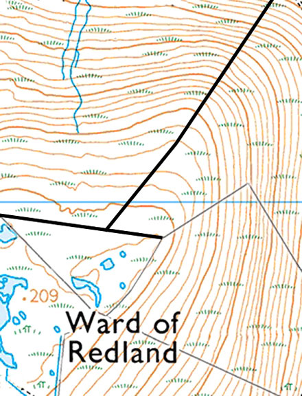
Modern field boundaries at the summit of Ward of Redland still mark the center trajectories of the Orkney triangle.
Since the ancients were fond of mirroring things, it came as no surprise to find the Orkney triangle mirrored on the landscape, its southern tip touching the very edge of the island of Hoy, its construction lines marked by 18 known sites (despite a fair portion of the land now underwater), and just as Point of Cott marks the extreme north of the archipelago, so its mirrored opposite marks the southernmost. If ever there existed a horned mound here it is now submerged.

The Orkney Triangle and its mirror, with ground markers revealing its construction
Orkney’s other oddity is the splendidly preserved Maeshowe, a passage mound predictably catalogued as a burial site despite the absence of human remains. Architecturally the inside of Maeshowe shares more in common with passage mounds of Mycenia and the kurgans of the Black Sea region than it does with Scotland. Kurgan derives from the Armenian kura-garq, ‘crucible of the social class’, and in the context of a circular building denotes a meeting place for high-ranking people – a select priesthood, if you like. The variant kura-grag (‘crucible of fire energy’) implies an astronomical connection and ties in nicely with Maeshowe’s alignment. However, anyone hoping to see the setting midwinter Sun reaching the rear niche will be three weeks too early to witness it, thanks to the effects of Precession.
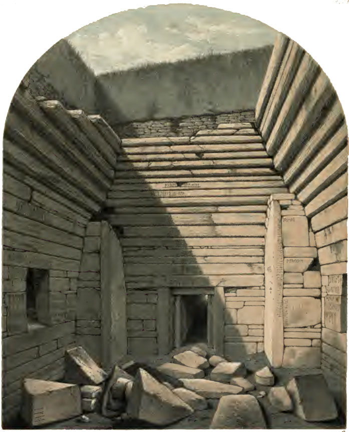
Interior of Maeshowe during Farrer’s excavation 1862
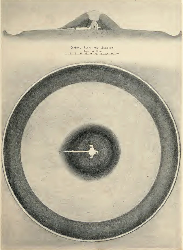
Plan and aerial view of Maeshowe and ring
Crouching inside the passage of Maeshowe affords a selective view of a horizon formed by lowlands and the gap between the slopes of Ward Hill and Knap of Trowieglen on Hoy, essentially suggesting a bowl into which an object descends. Taking the earliest C-14 date of the mound at face value, it would have been 3990 BC when the midwinter Sun was seen descending into this bowl, followed by the Moon at its Minor Standstill, consecrating the cosmic marriage of masculine and feminine. But there’s more. On that same night Orion’s Belt is seen descending into the same bowl, a performance repeated once more on the spring equinox. The date implies Maeshowe was a later addition to the area, as proved by the discovery of an earlier stone platform with sockets for two massive stones, around which the mound was later erected.
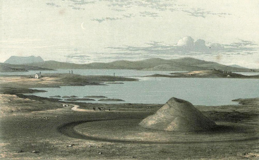
Maeshowe with Stenness and Brodgar in the distance, 1862
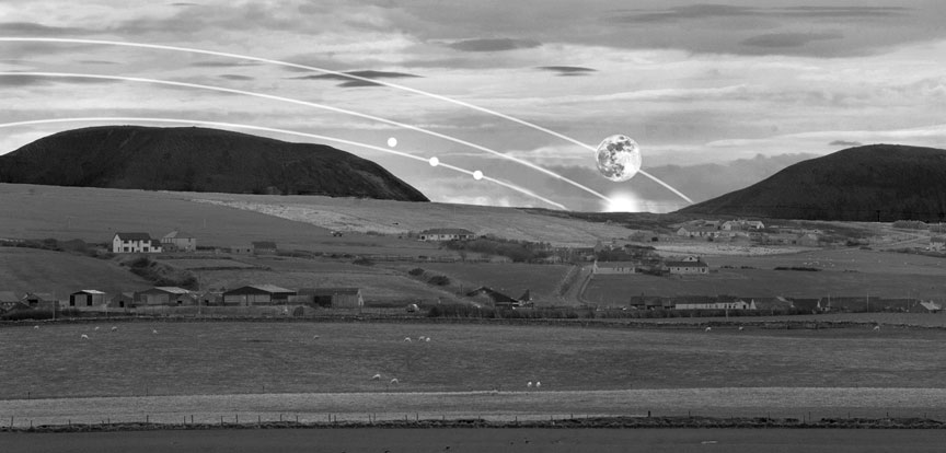
View from Maeshowe’s passage of the natural bowl into which set the Sun, Moon and Orion’s Belt in 3990 BC
The surprise here is that ancient people rarely if ever commemorated or celebrated the setting of objects in the sky, but rather their rising or mid-heaven positions when the energy of such ‘gods’ was deemed to be at its most abundant. Much in the same way, no one celebrates an empty glass of Scotch. This glitch at Maeshowe has been bugging me for years, leading me to speculate that the mound’s reference to the setting of celestial objects was important to people for whom this was culturally significant, and as far as I’m aware, the Egyptians and Armenians are the two rare cultures known to do so. In the Armenian language, Maeshowe appears as marz-hay (pronounced mez-hui), the ‘domain of Armenians’ or ‘domain of Orion’ (hay/hayk refers to both Orion and Armenians). Bringing the Armenian god Ara into the equation, where, depending on the context, the root ar means ‘assembly’, ‘nobility’, ‘power’ and ‘sun’, we can take the variant mes-ar to mean ‘assembly of nobility’ or ‘assembly of the sun’.
Archaeological, genetic and archaeo-astronomical data suggest the ancient architects bypassed mainland Britain and arrived first in Orkney, then followed west towards the Outer Hebrides. Hebrides is a corruption of Hy Bridhe, ‘Isles of the Brides’, possibly in commemoration of the Gaelic goddess Bridhe. Another possibility rests on the movement of language, with Gaelic having evolved from Indo-European regions, specifically Asia Minor, with elements of Egyptian. With the Armenian language as the root, the word bryge was applied semantically to an elevated or illustrious class of people who originally migrated from the Armenian Highlands to western Europe; hy, on the other hand, is a contraction of hye, a person of Armenian origin, which itself derives from hayk, the Orion constellation. Thus to an Armenian visitor, Hye Bryges ostensibly means ‘domain of noble people of Orion’ or ‘domain of noble people of Armenian origin’. This may explain the Gaelic term for the Hebrides, Inse Gall, ‘islands of the strangers’, most likely given to a people arriving from afar of sufficiently contrasting physiognomy for it to be memorialized.
Stone circles and standing stones are also a feature of the Outer Hebrides, the Isle of Lewis in particular. Just as Brodgar and Stenness are both located on major fault lines, so the impressive stone circle and cruciform stone rows of Callanish, along with its attendant sites, cluster within an extremely strong gravity anomaly zone, while the circles themselves delineate a localized region of low natural magnetism. It is therefore odd that amid such meticulous calculation, the ancient architects chose to place Callanish where a prominent crag by the name of Cnoc an Tursa blocks an otherwise uninterrupted view of the horizon. Looking at Callanish from afar, it becomes clear that the circle and its central monolith are deliberately using the mound-shaped crag, least of all because sockets for the missing stones are located there, along with a large back-filled socket for a stone whose scale would have created a focal point in itself.
Callanish central ring, with Cloch an Tursa on the far right
I recalled the stone circles of Orkney and how they mirror the first rising of Orion’s Belt on the winter solstice c.5300 BC. No such association has ever been explored at Callanish, but if made it would establish a coherent pattern of behaviour by the elusive architects. Standing inside the circle looking down the southerly row of stones towards Cnoc an Tursa, Orion’s Belt rose for the first time above the crag on the winter solstice c.5000 BC. At the same moment, looking back at the opposite end of the avenue, which aligns to the celestial pole, the bright star Vega appeared above the stones. This dual relationship presents itself at another striking ancient monument 2500 miles away in the region that used to be ancient Armenia – the enigmatic Stone Circle D at Gobekli Tepe – the difference being that it took place there five-and-a-half thousand years earlier. As I published in my previous book The Missing Lands, the original site was located in Armenian territory and called Port-asar, literally ‘umbilical cord of Osiris’, who is the earthly counterpart of Orion.
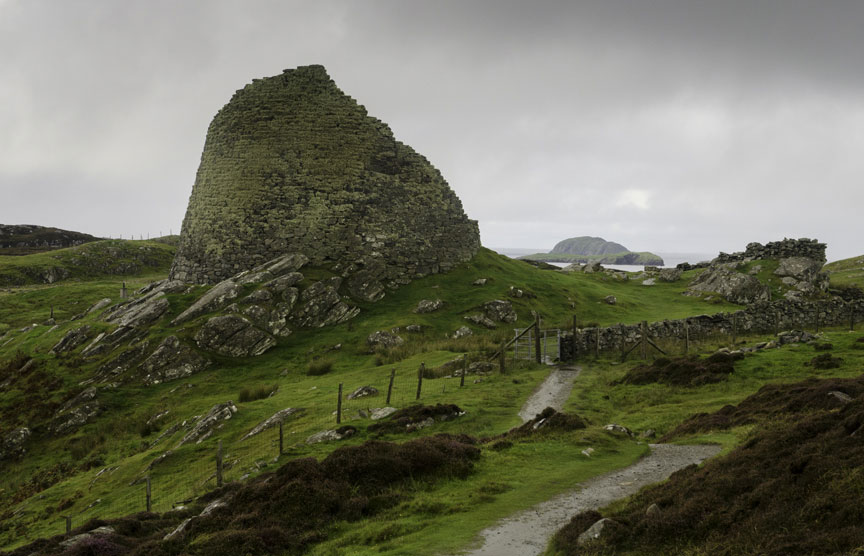
Be that as it may, the most unusual monument on Lewis is neither a megalith nor a stone circle. A few miles north of Callanish stands a tapered stone tower, Dun Carloway. Like others of its kind, it has vexed historians because these iconic structures are unique to Orkney, Shetland, the Western Isles and the tip of northern Scotland. To quote one: “It means that we have here the remains of a period of architectural activity which has no parallel in the early history of our country.”
Dun Carloway has been used, reused and adapted over time. It is built of well-fitted stone without mortar. The central courtyard is surrounded by a hollow wall, inside which a staircase winds its way to where there used to be upper galleries; windows appear to have been sparse. The tower incorporates features far and beyond what is necessary in a residence, for example, the design is based on music ratios: its external to internal diameter conforms to the octave; the main door is framed to a ratio of 1.33:1, equivalent to the note F; the wall from north to south varies in thickness by Pi. It’s as though the residence was intended for a musician or a mathematician.
Or an observer of the sky perhaps? The entrance is impractically placed to face the most windswept direction off the ocean but faces a pointed rock ledge that references the Minor Lunar Standstill as well as the Crossquarters – the midpoints between solstices and equinoxes that mark the beginning of seasons in the Celtic calendar. All this specialist information seems far beyond the everyday requirements of eating and sleeping. There is evidence of people living here in 100 BC but if the tower was meant to offer long-term protection from raiders (the other explanation), the fact that it could shelter no more than a dozen people and animals comfortably, and had no access to a well or sewage disposal, means that two weeks of siege was all the effort required before the besieged began to look at urine as fine wine or to each other as a source of nourishment. There is also the problem of the tower standing fifty feet lower than the adjacent bedrock. As any military strategist knows, if you don’t own the high ground the outcome will not be positive.
Perhaps the tower, like the ancient monuments around it, was inherited from an earlier period and re-used by different people with different needs? Put through Armenian etymology Dun Carloway is best broken down as: dun(dwelling) or dohm (a noble race or family); and kar (stone), ogh (ring or circle), e’ag (being, existence), forming Dun Kar-ogh-e’ag, ‘existence of the circular stone dwelling of a family of noble race.’
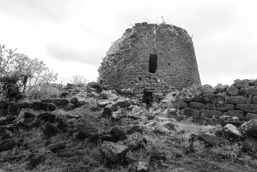
A trip to the Mediterranean island of Sardinia reveals 6500 towers resembling Dun Carloway, each with traditions associating them with seafaring astronomers, very tall ones at that, who migrated here over 8000 years ago from the Armenian Highlands, leaving a genetic footprint in the present population. Such nuraghe lent their name to an entire civilization and yet no one can satisfactorily explain where this word came from or what it means. Many nuraghe can comfortably house no more than four people and have no access to water, making them useless as fortifications; certainly, they were not cost-effective. However, their low entrances, dark interiors, and narrow windows focussed on the artificially flattened summits of nearby hills are all indicative of observatories. Indeed, one observation at nuraghe Ruju and Santu Antine allowed me to calculate the first to mark the rising of Orion and Sirius out of the summit on the winter solstice in 6000 BC, then watching their trajectories descend into the next flattened summit, as observed from the window in nuraghe Santu Antine.
Dun Carloway. And nuraghe Ruju in Sardinia, where 6500 similar towers predate those of Scotland
And just as Bookan is the odd one out in Orkney, so in Sardinia the Ruju-Santu Antine alignment is completed by the passage mound Sa Coveccada, forming a near-straight line, with the third site offset by 2 degrees, altogether mirroring the belt stars of Orion — as they appeared above this location at mid-heaven in the era of 6000 BC.
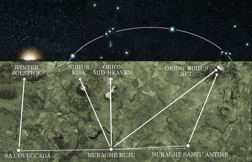
Sunrise, and trajectories of Orion and Sirius as observed from windows in nuraghe Ruju and Santu Antine, and Sa Coveccada. 6000 BC
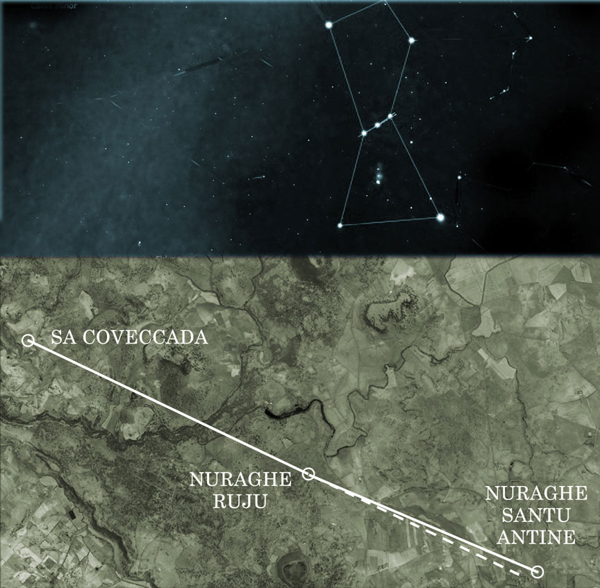
The mirroring of Orion’s Belt in Sardinia
Sardinia is also home to horned mounds, possibly the oldest in existence. They are classified as tomba di gigantiexcept no giants’ remains have been found inside the orthostatic boxes that once were covered with soil, just like the Orkney mounds. Instead, the remains of very, very tall people have been found all over the island in common graves. A cursory investigation into the alignment of these horned mounds indeed finds them all predating those on Orkney by as much as 2500 years, with many marking the rising of Orion on the winter solstice from 4000-5200 BC, with the site at Iloi marking its mid-heaven position in 7200 BC, and Li Loighi and Imbertighe establishing the oldest correspondence, on the equinox of 8500 BC.
Now it gets interesting. As language and people moved westwards from Armenia into the Mediterranean, towards the islands of Malta and Sardinia, the Maltese word nur is traced to Azerbaijan (what used to be old Armenia), its aggregate meaning being ‘just or rightful, light or shining person’. Classical Armenian offers specific details about these rightful people. The word nuirag refers to a ‘holy representative or legate’, from which derives nuyral (devoted). Altogether, the nuraghe of Sardinia are best described as places of ‘the rightful, white, shining, holy representatives’. Incidentally, the Armenian solar god Ardi was wedded to the goddess Sel-ardi, and as the name migrated it took on the shorthand form S’ardi, as in ‘belonging to Ardi’, from which developed Sardinia, ‘the land of the bride of the Sun’.
This overlap of values between ancient Armenian culture and Sardinia, along with people clearly attached to Orion, led me to examine the origin of Scotland’s sacred place names. Orkney is best defined as ar-kar-negh (narrow stones of the god), a possible reference to the visual characteristics of Stenness. This seat of council comes up as tses-nisd (place of ritual) and s’tenel-nish (to place a mark). But Egyptian etymology is even closer to the mark: s-ten-nes (to arrive at a distinguished place), and seh-t-en-nes (to approach the place of council).
Perched on high ground, the Ring of Bookan or Bukan forms the tail of a string of circles. In Armenian, poch’-gahmeans ‘tail stones’ (bear in mind that certain vowels and consonants are interchangeable due to linguistic and geographic variants over time).
The Ring of Brodgar, or Broggar, is described in local folklore as a place where giants danced to music and were turned to stone. Its Armenian equivalent barerq-kar means ‘dance song stones’. However, there is an even closer Egyptian root: b-ra-gah, ‘abode or shrine of the Sun god’.
Turning to the stone circles of Lewis we find Ceann Hulavig’s original Gaelic name Sron A’Chail to originate from the Armenian srah achk-aha, ‘the room of seeing’.
The summit of Callanish is marked by the outcrop Cloch an Tursa, and tur-sar literally means ‘door or gateway to the summit’.
As for Callanish, it was so good they named it twice. The first Armenian interpretation remains almost intact: kar-nish (a stone marker), along with the variants kharag-nish (rock cliff marker), and khachanish (to mark or cross). The site’s Gaelic name Tursachan is explicitly referenced as tur-sa-quah (doorway to the stone seat or throne), although a visiting Egyptian might expand on this with Ta Ur S-aqer, ‘to make perfect the great land of the gods’.
Callanish 1859, still partially buried in peat

Callanish and its earlier Armenian sibling, Karahunj
But who might these gods have been? The only surviving reference to the ancient architects are their names: Papae and Peti.
The Peti of Orkney were considered to have been the original settlers, described as “people of strange habits” who spoke a different language. Both Peti and Papae were associated with abodes of a sacred nature and wore long white robes, the kind of garment typically identifying a priest or sage in ancient temple tradition. Perhaps one group mapped the sky while the other attended to stonemasonry and monuments, anchoring the calculations to the land. Such a division of roles was common in the temple raising practices of ancient Egypt, and an examination of these people’s etymological fingerprint reveals a definite intertwinement. Access to the Egyptian temple was restricted to the learned, the purified and the initiated, qualities reflected in their white robes of office, and the title petriu, ‘those who see’ — visionaries, initiates with more finely attuned faculties, precisely the kind of responsible individuals one wants in charge of a sacred environment. The related term petiu is even closer to the Scottish name. It means ‘heavenly beings’, while the derivative petr means ‘a region of sky’, so clearly the petriu or petiu, and by extension, the Peti, were involved with understanding the stars. They were referred to in Persia (the region known earlier as Sumeria, whose cultural stratum overlays earlier migrants from Armenia) as peri, whom they described as elegant and puissant, tall and graceful people possessing the gifts of clairvoyance and the ability to walk between worlds. The name followed them to Ireland where it was modified to Feadh-Ree (faery, the fair people) to reflect the local dialect.
The name Papae, on the other hand, comes from the Armenian p’apegh, a monk or holy person. Its diminutive papdenotes ‘a grandfather or elder’, while the extension papenakan means ‘inherited from ancestors’.
If the picture painted here is correct — and I am paraphrasing an entire book — then we are presented in Orkney, the Hebrides, and Ireland too, with a priestly class possessing an ancient inherited knowledge handed down from an established yet remote culture, and as early British chroniclers correctly noted, they were not local. As from where these strangers might have originated, on the basis of modern population samples, one genetic group migrated from Scythia to eastern Scotland, while Y-chromosomal evidence suggests a second group migrated up to 3000 BC from the Mediterranean and Iberia to the western and southern British Isles, contributing 24% of modern genetic lines. But perhaps the most telling study concerns the DNA of Scotland’s highly diverse people, which pinpoints their origins in Siberia, Arabia and Egypt.
Source: Freddy Silva, Scotland’s Hidden Sacred Past, published December 2021. Author website by invisibletemple.com
“Bukan is bonny oh, and there lives my love. My heart it lies on him, and will not remove. For Annachi Gordon, oh, he’s bonny and he’s brave…”
Hi Graham , my name is Robert Friend , I’m an amateur archaeologist living in Scotland & a big fan of your writing & talks! I’m not sure if your aware , but there are the remanence of some horned chamber tombs on the Isle of Arran in the firth of Clyde , interestingly they are known as the giant’s graves , located on the south of the island, I’m pretty sure they must have a connection whit the same , builder mentioned in this writing! Would be interested to here your thoughts on that?
Hi Robert,
I’m traveling to Scotland this summer and am interested in visiting some sacred sites. Unfortunately, I’m traveling w a group and we have an itinerary. However there will be some free half days, late nights and early mornings that I can break off. Please let me know if you have any suggestions for my to research and see while I’m there. Im staying in Forfar for 3 nights, Dornach for 4 nights, St. Andrews for 2-3 nights.
Any ideas and suggestions would be appreciated. I obviously need to come back again and get off the mainland to see a lot more. THANK YOU.
It’s amazing how the shining ones pop up everywhere in ancient times.
This is just generally relevant, but…
An associate commented long ago (forty years?) that the stone circle observatories found worldwide are not really circles, but ellipses whose ellipticity varies appropriately with latitude.
Very few commentaries on the stone circles suggest that view.
Does the Graham Hancock following have an observation on this?
Just curious. I have nothing helpful to contribute. Sorry.
Another piece to the puzzle are the numerous unexplained stone ‘Ancient Fortress’ located through out the river valleys of Eastern United States.
Is this “ellipticity” thing the same as the Uriel machine latitudes and the lozenges found, for example,at Rosslyn?
Thank you Freddy Silva and Mr. Graham Hancock!!!! Once again, the content on your website makes my research more alive!!!
It’s so refreshing getting lessons on real history other than the water down version that modern Academia regertates. I suspect it’s because, it’s their way to control the masses. For it’s hard to know where you’re going if you can’t discern where you’ve been. And that my friends, is more frightening than anything.