


We warmly welcome Simon Miles, author of The Map and the Manuscript: Journeys in the Mysteries of the Two Rennes, as our featured author for March.
In his debut book, Simon documents his investigation of over more than twenty years into the “affair of Rennes”, a tangle of puzzles that has fascinated readers and researchers for half a century. Amongst a sequence of breakthrough original insights, The Map and the Manuscript reveals for the first time the traces of a remarkable artefact of the ancient world, a geometrical complex laid out with impressive accuracy and at large scale between certain peaks, churches and châteaux in the landscape of the Pyrenees mountains. This discovery leads to a far-reaching exploration across a rich expanse of topics, from sacred geography to French poetry, from alchemy to dreams, from the Temple of Delphi to the streets of Paris, from hidden designs in old books to secret codes in manuscripts. In his article here, Simon offers some of the insights gained during his extensive investigation into this compelling mystery.
Interact with Simon on our AoM forum here.
One day in the early 1990s, browsing in a bookshop in Melbourne, I stumbled upon a small book called The Holy Place: The Mystery of Rennes-le-Château – Discovering the Eighth Wonder of the Ancient World, by Henry Lincolni. The author claimed to have found alignments between ancient churches, châteaux and mountains in a region in the foothills of the Pyrenees in the south of France. I was always interested in such topics, and so I bought it and read it. I had no idea that it was the beginning of an adventure which was to keep me occupied for the next three decades.
The book was fascinating but frustrating. It was quite unlike anything I had read in this vein before. The sheer volume of alignments which the author had found was tantalising, but there was no way to check the claims as the reproductions of the maps were simply too small. If the claims held up to scrutiny, then something very remarkable was going on. But did they? I decided to find out.
I ordered the 1:25,000 scale map on which Lincoln had based his work from the Institut Géographique National (IGN) in Paris. When it arrived, I set to work on a methodical page-by-page review of his book. To cut a long story short, I found, in general, that the claims of alignments held up, but the claims of more complex geometry were not nearly as convincing. I found the map very curious indeed and began to study it closely.
Very soon after, I made a discovery which changed everything and convinced me that there was, indeed, something very significant going on in the landscape in this secluded valley of the Haute Vallée de l’Aude, the High Valley of the River Aude, in the Languedoc of southern France. It is a place rich in history, and, as it turns out, also in mystery.
There are two small villages in the region, Rennes-le-Château, and Rennes-les-Bains, around which a nest of curious mysteries has arisen. These stories have gained global exposure in a whole genre of books culminating in The Da Vinci Code by Dan Brown. Far too involved to summarise here, they involve the classic elements: lost treasure, unexplained riches, coded parchments, secret societies and mysterious maps. Henry Lincoln, a BBC writer, had previously made several documentaries and written best-selling books in this fieldii, but frankly, these other topics held little interest for me. I couldn’t see any relevance of such matters to the question of ancient geometry in landscape, so I put them to one side.
The early discovery spurred me on. One thing led to another. In an unexpected twist of fate, I was fortunate to end up living in France for several years, in a house on the very map I had ordered from Australia all those years ago. Over the years, I have made, if I may say so, some inroads into the problem of the landscape geometry in the area. But something else has also happened. As it turned out, I was completely wrong that the problem had nothing to do with the modern mysteries around the two villages named Rennes.
One: The 45° alignment
One alignment in particular discussed in Lincoln’s book made a strong impression on me.
It passed through five ancient sites over a distance of around seven miles, and offered a strong case that it had been laid out intentionally.
The line was not found by Lincoln, but had been originally discovered and described by another researcher, David Wood, in his book Genisis (1985)iii. Neither of them seemed to have noticed, however a detail that caught my attention: it fell on a precise bearing of 45°.
The alignment ran (in order from the south-west corner) from the church in the tiny village of St Just-et-le-Bézu, through a Templar commanderie at Lavaldieu, the church of Rennes-les-Bains, and through another Templar château at Montferrand (now in ruins). It terminated at the north-east end at the Château d’Arques, a very curious square stronghold tower set in a large rectangular walled compound dating from at least the 11th century AD.
Below is a depiction of the alignment in Google Earth.
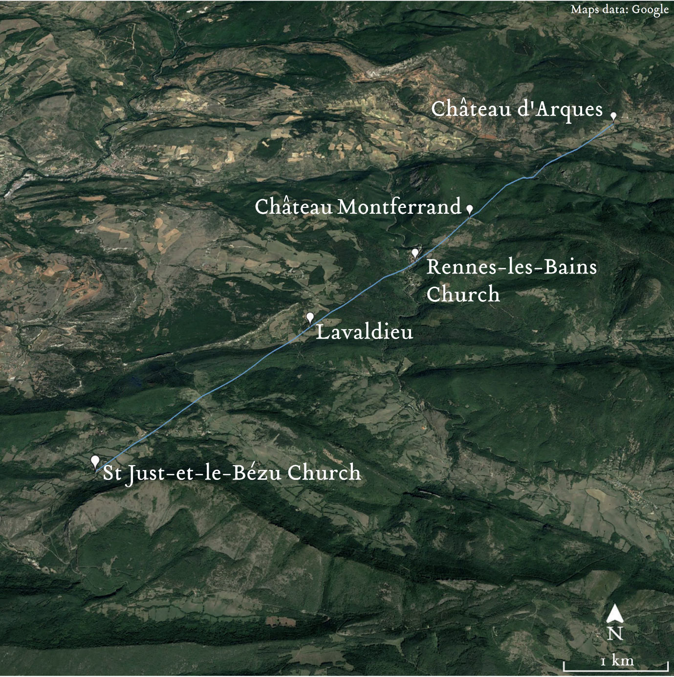
Figure 1: The 45° alignment
Here is a photo of the Château d’Arques, looking towards the west. The four sides of the square tower are aligned to the compass angles, north, south, east and west, and the roof is marked by crossed diagonals.
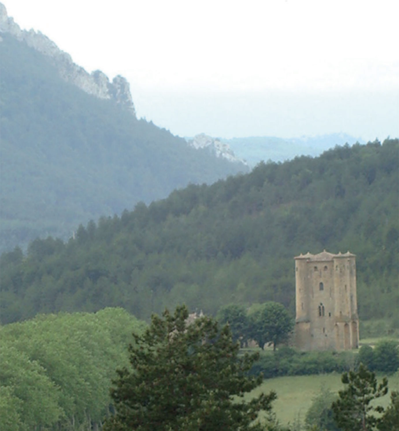
Figure 2: Château d’Arques
I’ve also made a series of videos in Google Earth Studio. Here is the first showing the 45° alignment.
Figure 3: Video: The 45° alignment.
This 45° line, comprised of five sites, in relatively close location, in excellent alignment, on a significant compass-angle bearing, seemed to me to be a very strong candidate for an intentional geometric intervention in landscape by humans of an earlier era. I began to wonder whether there might be other examples on other angles. The most obvious candidate was a meridian, a north-south line. If there had been a genuine programme of laying out alignments in the landscape, a meridian would be a useful line to mark, even perhaps a good place to start. Were there any examples on the map of meridians passing through multiple mountain peaks, churches or châteaux, I wondered?
Two: Meridians in the Mountains
The act of marking a meridian is a fundamental – perhaps the fundamental – human intervention in the world. It is the primary expression of our relationship to physical space. To define a meridian requires an understanding of the relationship between sun and earth and observer. It is the first act in establishing one’s location and is the precondition for all competent navigation. It lies at the root of our conception of time, as well as space. In this sense, it can be considered as the primal expression of human consciousness. Nature does not mark meridians; if we should find one, it can only have arisen through conscious intent.
So, I set out to find examples of meridians on the map. I was looking for north-south alignments passing through the peaks of mountains or ridges, and through churches or châteaux. I oriented my long transparent ruler with the left side of the map so that it was aligned north and south. Then I began to move it slowly and carefully across the surface, keeping it parallel. I had made my way about half-way across the map when I found what I was looking for: two peaks falling on the same north-south line. The first was Le Sarrat Rouge, (the Red Hill), the local highest point of the plateau on the west bank of the River Sals.
The second was a very distinctive local highpoint and popular lookout called La Pique, which culminated in an outcrop of jutting rock at the highest point of a large triangular ridge. My ruler showed a perfect meridian between these two marked positions, Le Sarrat Rouge and La Pique.
As I traced the line further to the south, I noticed that it passed over two parallel ridges or crests, which ran approximately east-west across the landscape. It took me a few moments to realise that in both cases, the meridian crossed on the highest marked spot height of each crest. There were four local high points in close proximity falling with unerring precision on the same meridian, namely 2°17´50˝E.
It was far more impressive than I had dared to imagine, consisting of four distinct peaks on an impeccable, razor-sharp meridian alignment. Even more remarkable to me was the fact that the peaks ascended in height, from north to south.
This implied that if one were to view the scene looking southward from a convenient vantage point further to the north, on the same meridian, one might expect to see the four peaks “stacked”, one above the other. There was indeed such a suitable vantage point to the north, a long high ridge which ran east-west across the landscape and acted as a natural northern border of the plateau which offered a perfect view of the peaks and valleys to the immediate south. The point where the meridian crossed the sighting ridge bore the name: L’Homme Mort. The Dead Man.
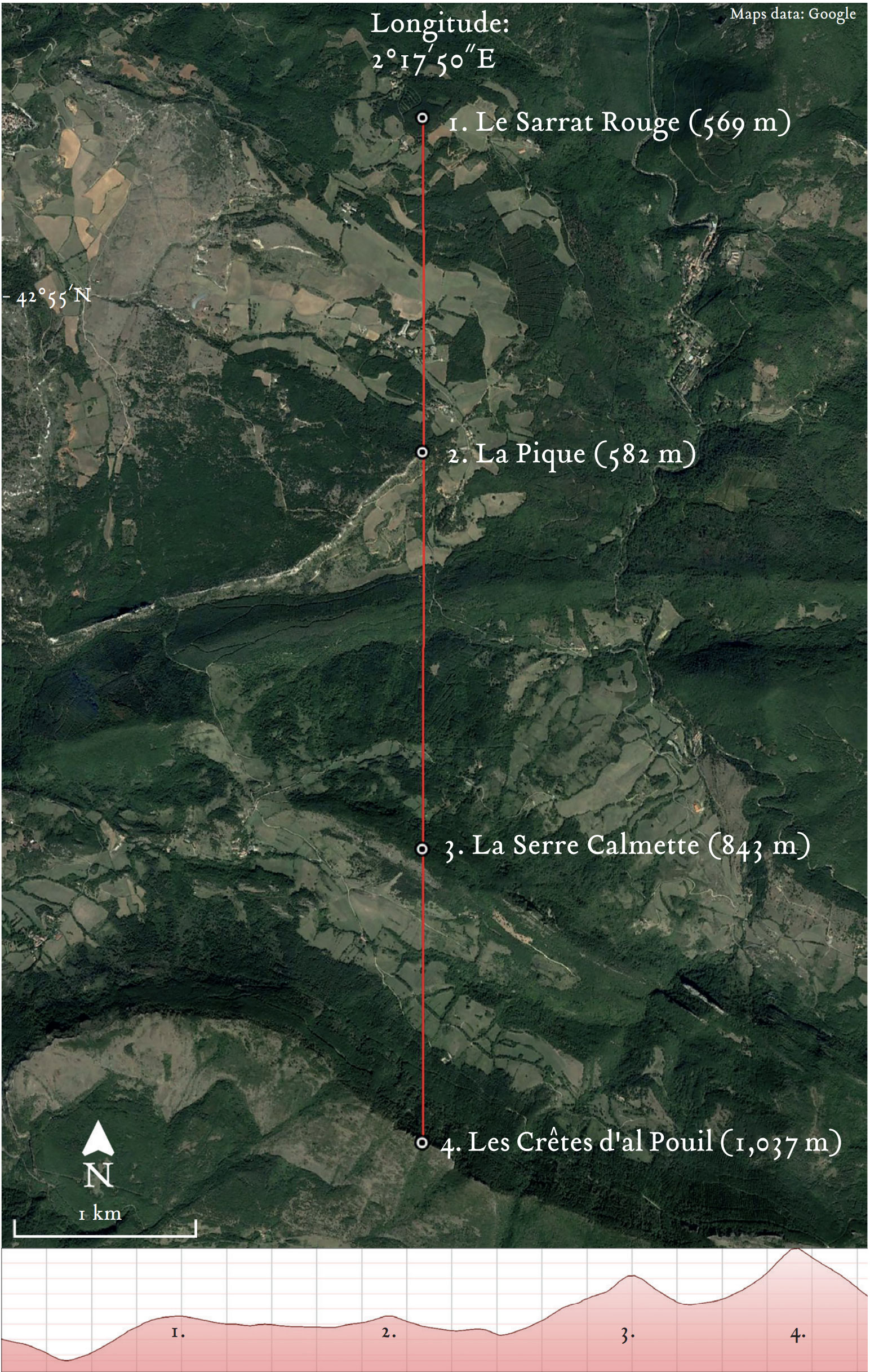
Figure 4: The La Pique meridian
Figure 5: Video of the La Pique meridian.
I had only searched half of the map, so I still had further work to do. I resumed moving the ruler, continuing to the east of the La Pique meridian. It only took a few minutes before I stumbled upon a second example. And this one, if anything, was even better than the first.
The highest peak on the plateau immediately surrounding the two Rennes is Pech Cardou. At 795 metres tall, it is dwarfed by the higher mountains of the Pyrenees to the south, but it is nevertheless an imposing sight visible from miles around. It is found to the east of the River Sals, a short distance north of Rennes-les-Bains.
When I reached the summit of Pech Cardou on the map, I leaned in to inspect the path traced by the edge of the ruler. To my utter astonishment, it passed exactly through a total of eight peaks to the south. These nine positions all fell on a precise bearing of 180°.
Incredibly, there was also a tenth peak on the same meridian, to the north of Pech Cardou. Again, this offered a convenient high vantage point from which one might view the entire meridian. In this case, the viewpoint was a spot height marked 802 m, named Planditou on the map, the highest point of the same long ridge on which was located L’Homme Mort, the vantage point for the La Pique meridian, further to the west. Ten “peaks”, (which included several highest points of ridges, or crests) fell without deviation on the precise 180° line ruled through the summit marker of Pech Cardou on the map.
Furthermore, proceeding south from Pech Cardou, the eight peaks also rose in order of ascending height, from north to south. This implied that to an observer on the summit of Cardou the peaks would appear, again, as if they were stacked one above the other, stretching away to the south and culminating in the towering peak of Pech dels Escarabatets at 1,190 m. The meridian falls on longitude 2°19´40˝E.
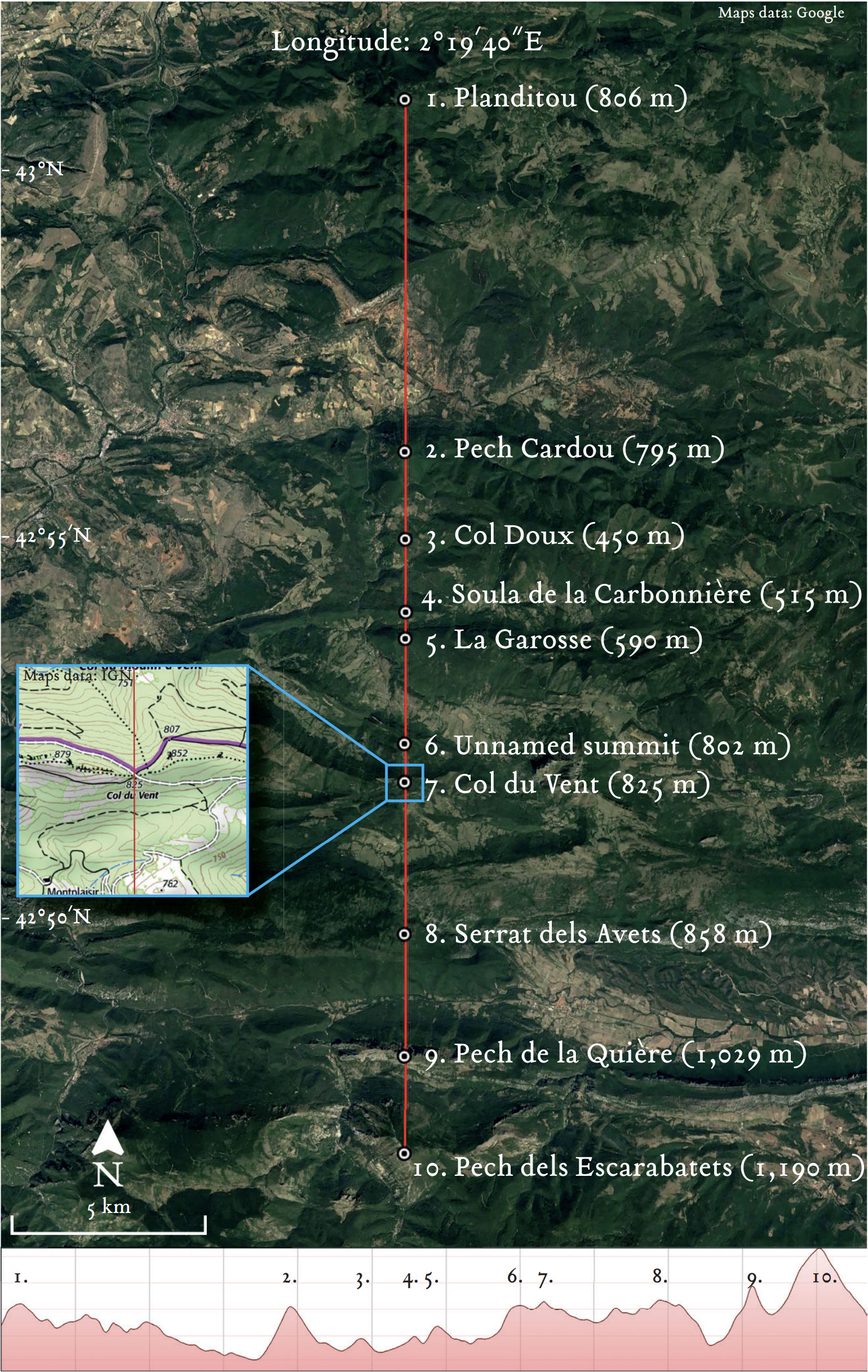
Figure 6: The Pech Cardou meridian
Figure 7: Video of Pech Cardou meridian.
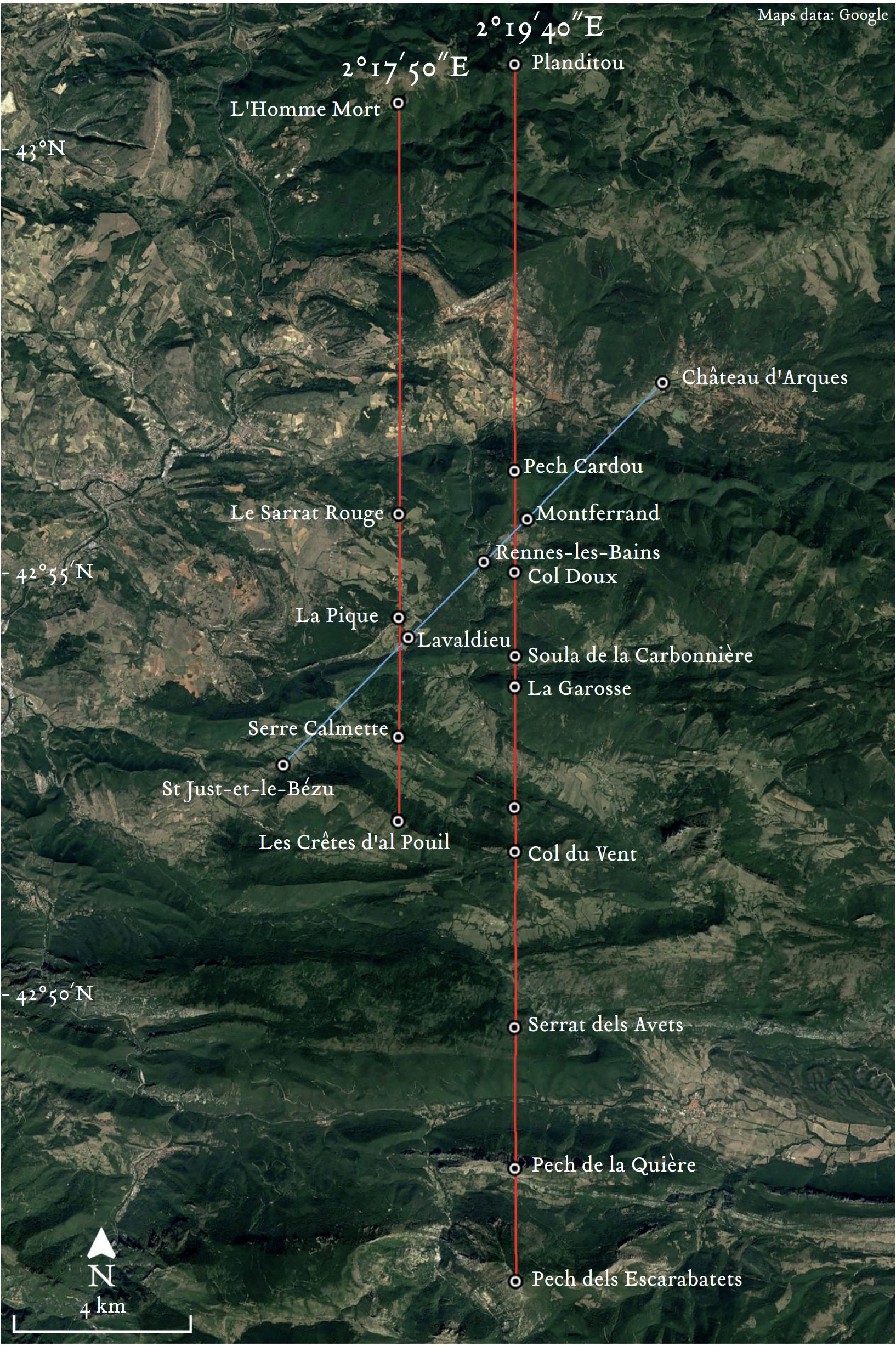
Figure 8: The two meridians of La Pique and Pech Cardou and the 45° alignment
Figure 9: Video: Two meridians and the 45° alignment.
If one meridian on its own was powerful evidence for intentional intervention in landscape by humans, then two of them, so close together and so accurate, must surely be considered as close to definitive proof. For me, there was no longer any possibility that these might have arisen naturally by the play of random geological forces, or simply by chance.
So many questions occurred to me. If human activity had been involved in creating these lines, what could that mean? Can a man move a mountain? Can he nudge a peak, a little to the east, or a little to the west? In any case, I soon realised that the physical act of carving or otherwise altering the position of the landscape was not even the most challenging aspect of such an operation.
The real difficulty would have been in calibration. How could ancient man have reliably determined these precise compass bearings? How does one lay out an exact north-south line?
The discovery of these meridians in the late 1990s took the project to another level. The internet had arrived, and I immersed myself in the resources and connections that the online world offered, but it was not until another ten years passed that I had the opportunity to visit the area for myself at last. I ended up living there for five years, and had the opportunity to explore in person on the ground the incredible landscape I had become so familiar with from so far away via the map.
I was able to verify and photograph the meridians. Here is the La Pique meridian, taken from Le Sarrat Rouge, looking directly south towards La Pique and the two ridges beyond.
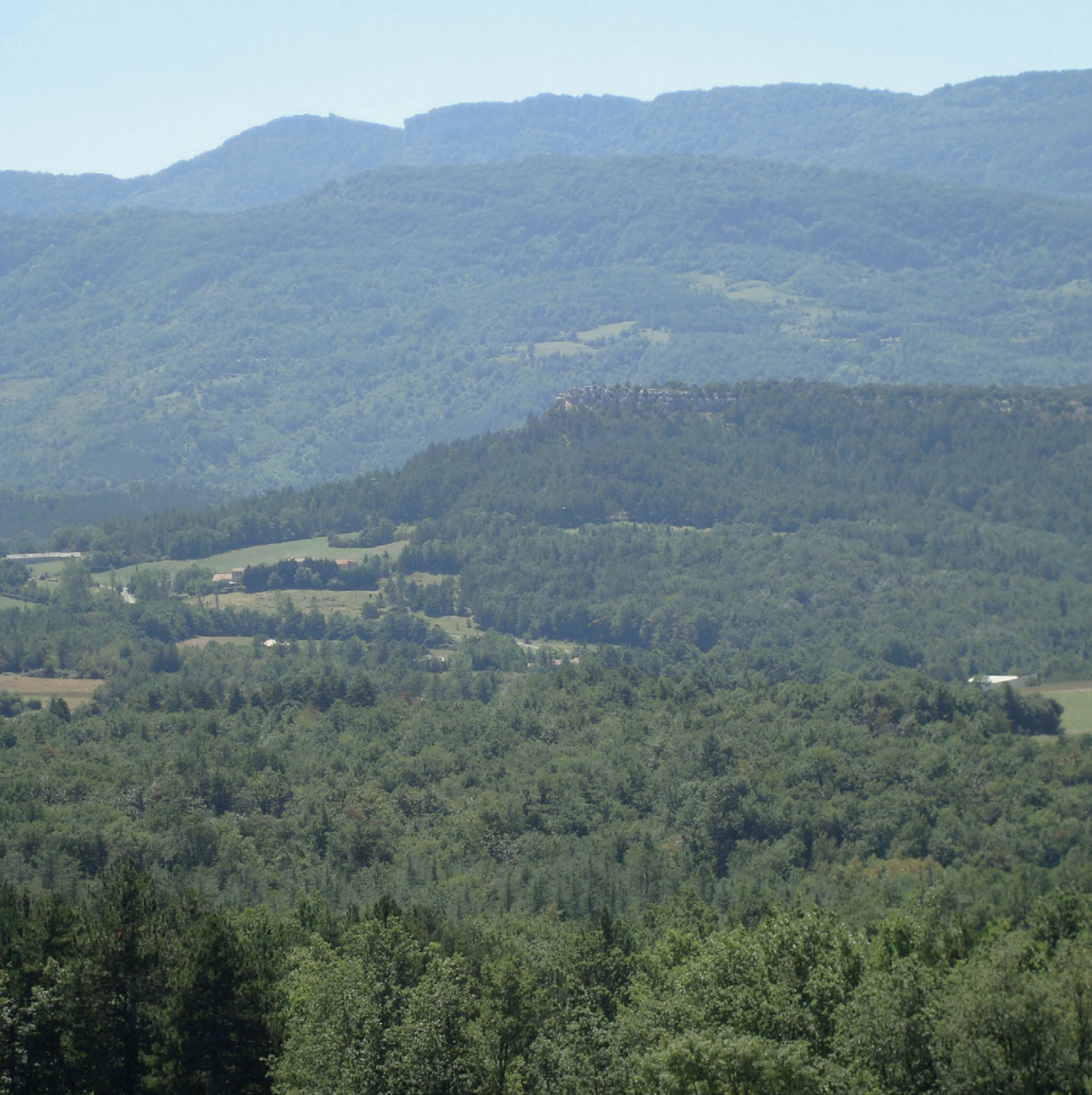
Figure 10: The La Pique Meridian: the view looking due south from the summit of Le Sarrat Rouge. It shows La Pique in the centre of the image, and the two ridges behind of Serre de Calmette and Les Crêtes d’al Pouil.
Here is the Pech Cardou meridian. The photo is taken from the southern slopes of Pech Cardou itself, towards the south and Pech dels Encarabatets.

Figure 11: The Pech Cardou meridian, looking due south from the upper slopes of Pech Cardou. Visible are: Col Doux in the foreground, followed by the ridges of Soula de la Carbonnière and La Garosse, the unnamed 802 m peak, the V-shaped groove of Col du Vent and Pech dels Escarabatets in the distance.
Living in the landscape was a revelation. I was able to explore in person the discoveries I had made on the map on the other side of the world. By now, Google Earth resolution had increased to make it a valuable means of visualising the geometry. I made many new discoveries and expanded the range of the alignments far beyond the confines of the original map. I found that many are correlated to significant angles including the winter solstice sunrise line, and the rising and setting of major stars and constellations.
I also discovered three more meridians, very remarkably located between the two earlier examples! All five terminated at the northern end along the high ridge running east-west across the landscape, offering an ideal vantage point or platform from which to observe the meridians to the south.
The three new meridians were as follows.
The first, on longitude 2°18´00˝E, ran from the chapel in the Templar château of Bézu, then further south through three churches and two peaks.
The second, on longitude 2°18´28˝E, ran from Lavaldieu (on the 45° alignment) to Château Puislaurens to the south, one of the most spectacular of all Templar châteaux across the region.
The third, on longitude 2°19´10˝E ran from Rennes-les-Bains church to the south through three other sites.
All five meridians, and the 45°, are shown on the Google Earth image below.
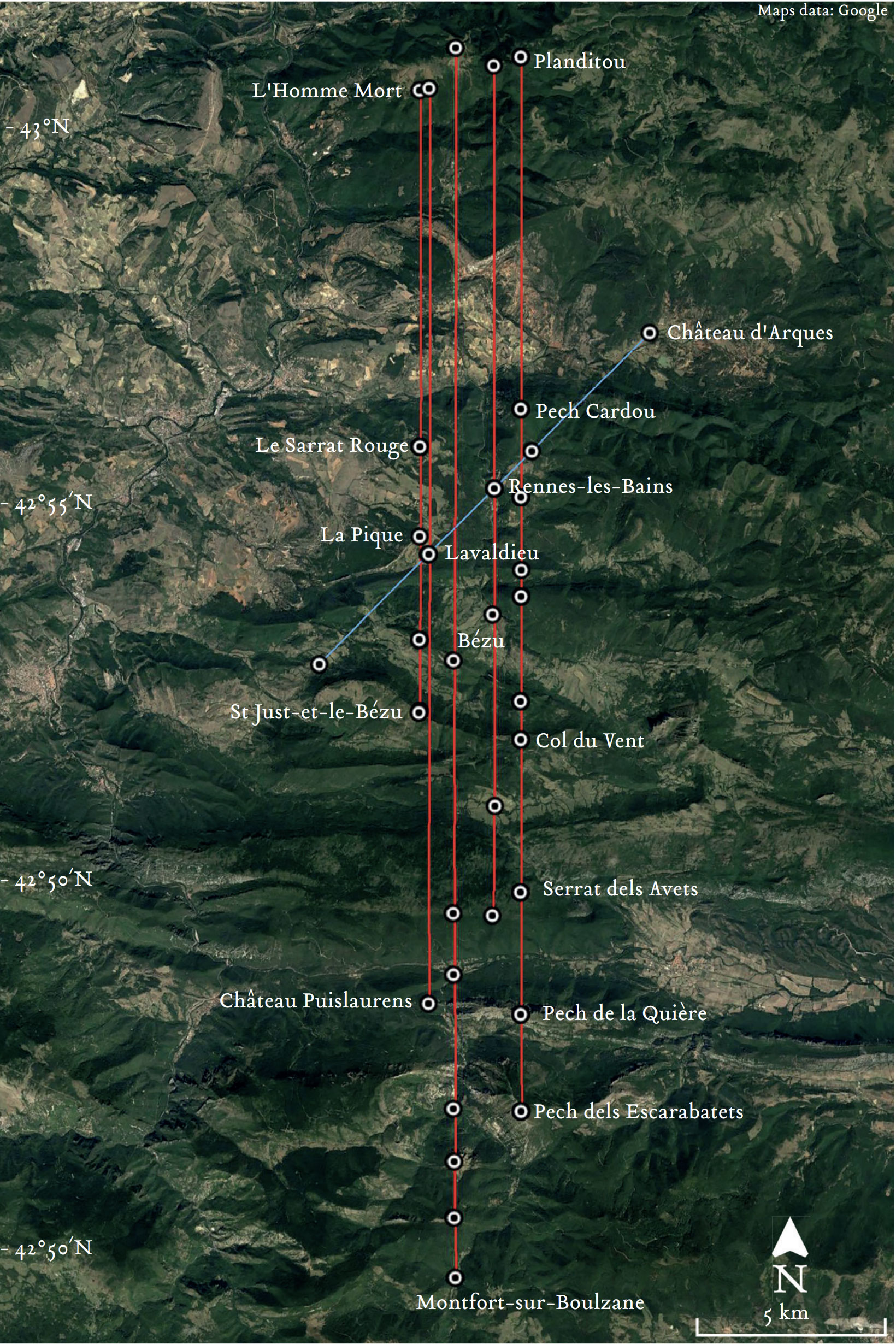
Figure 12: The Field of the meridians. The five meridians on Google Earth, from directly overhead. The sighting ridge is shown at top of image. From east to west, the meridians of: La Pique, Lavaldieu, Bézu, Rennes-les-Bains and Pech Cardou.
Figure 13: Video.
Three: Landscape Zodiacs
The practice of dividing the landscape around a city into a zodiac, or twelve-fold division, was widely if not universally, adopted in the ancient world. This was demonstrated in a series of seminal works written by a French researcher, Jean Richer, a professor of literature and an authority on the late nineteenth-century poet and writer Gérard de Nerval.
After a remarkable dream on a visit to Greece, he began to recover over many years the traces of an ancient conception of landscape or ‘sacred geography’ as he termed it. His first work on this subject, Sacrée Géographie du Monde Grec, was published in 1967 in Parisiv. Several more were to follow describing his discovery of zodiac centres throughout the Near East and around the Mediterranean, including as far west as the Iberian peninsula and Francev.
The first zodiac he discovered was centred on Delphi in Greece, shown below, reproduced in Google Earth. Six alignments divide the landscape into twelve segments, which are then allocated to the signs of the zodiac. He produced considerable evidence to show that this format was fundamental in the layout of landscape in ancient Greece, influencing the choice and symbolism of placenames, temples, coins and more. This pointed to a widespread and persistent effort, in Richer’s view to establish a harmonious link between the heavens above and the land below.
Figure 14: The Zodiac of Delphi. The major alignments and the allocation of zodiac signs to the twelve landscape segments according to Prof. Jean Richer in his book Géographie Sacrée du Monde Grec (Paris, Hachette, 1967)
Richer’s 1967 book was translated into English in 1994 by Christine Rhone as Sacred Geography of the Ancient Greeks: Astrological Symbolism in Art, Architecture and Landscape vi.
This book had a profound effect on me when I encountered it for the first time in the late 1990s, at the same time as I was setting out on this project. Then, in another of the unexpected turns which have marked this journey, I discovered that this same universal format which Richer had identified as the template for the layout of sacred centres in the ancient world was also present in the landscape around Rennes-les-Bains. But with a twist.
I learned, from a recent history of Rennes-les-Bains published in 2006vii, that the original axes of the ancient pre-Roman layout of the village of Rennes-les-Bains, the cardo and decumanus as they were known, were offset by 15° to the usual north-south axis on which towns were typically laid out, because of the unique topography of the valley in which it lies. The River Sals flows at this angle, and the village is constrained to a narrow strip of land running alongside.
When these axes aligned to 15° are combined with the 45° through the church of Rennes-les-Bains, they hint at a full division of the landscape around the village into twelve segments of 30°. Following the hints leads to solid ground. The alignments which make up the twelve-fold division are shown in Figure 16.
This format leads naturally to suggesting the presence of a zodiac in the landscape around Rennes-les-Bains. They also raise the question of whether Professor Richer himself might have been aware of this location and its background, given that his book was published in the same year, 1967, as the book which launched the “affair of Rennes” to a broader audience.viii These questions are explored further in my book.
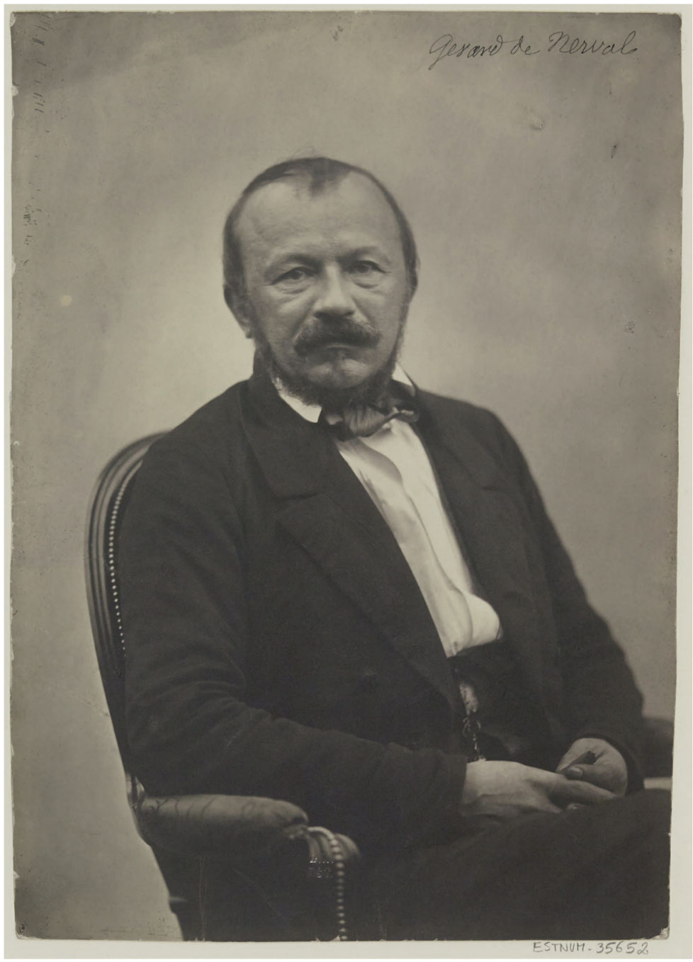
Figure 15: French poet, writer and journalist Gérard de Nerval (22 May 1808 – 26 January 1855).
Photograph by Félix Nadar.

Figure 16: A twelve-fold division of landscape around Rennes-les-Bains, an ancient tradition embedded in the geometric layout of the structures and peaks.
Four: The Arques Square
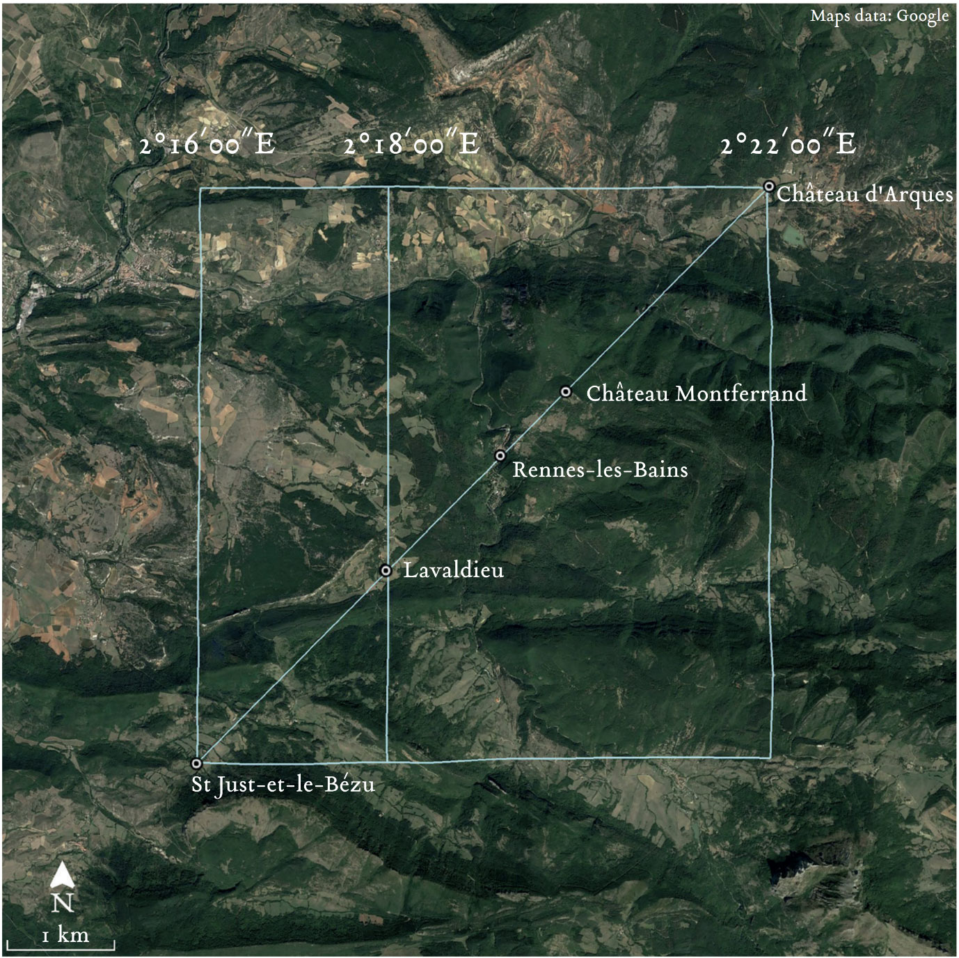
Figure 17: The Arques Square. The endpoints of the 45° alignment, St-Just-et-le-Bézu and Château d’Arques, fall exactly six arcminutes of longitude apart, at 2°16´00˝E and 2°22´00˝E, respectively. Lavaldieu falls exactly one-third of the way along the length at 2°18´00˝E.
It took many years of staring at the map before it occurred to me one day that if the 45° alignment was taken as the diagonal of a square, it has a width of exactly 1/10° of longitude. The square, which I named the Arques Square after the château marking the north-east corner, has many very curious properties.
I found that the midline of the square was marked by the centre of the village of Campagne-sur-Aude, the commanderie and headquarters of the Knights Templar in the valley.
I also calculated that the square has a width at the midline of precisely 25,000 pieds-du-roi. This unit of measure, equal to 326.6mm, was the most widely used foot in France from at least as early as the time of Charlemagne until the seventeenth century. The width naturally depends on the latitude. The Arques Square is located at the exact latitude for which 1/10° of longitude equals 25,000 pieds-du-roi.
The diagram below shows the position of the village in relation to the square.
It forms a pair of 40° right-angled triangles, each with a hypotenuse of 250,000 inches.
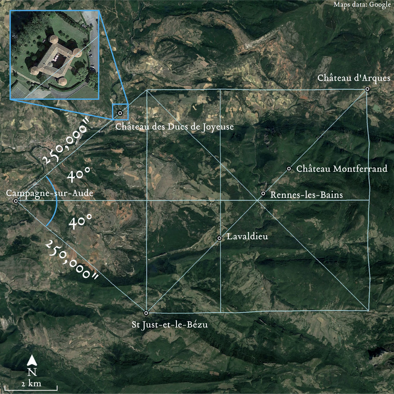
Figure 18: The geometry of the Arques Square, showing Campagne-sur-Aude on the midline. Note the two 40° right-angled triangles and how these define the western side of the Square.
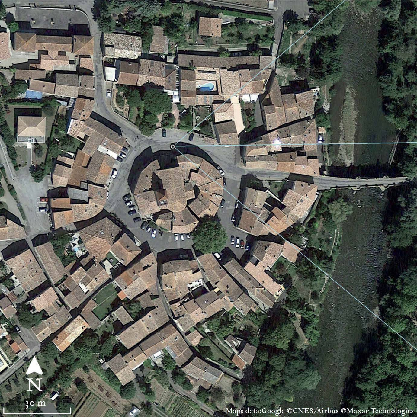
Figure 19: Zooming in on Campagne-sur-Aude. This shows the midline of the Square tangent to the north side of the circle of buildings at the centre of the village, just outside the door of the church.
Figure 20: Video: The Arques Square.
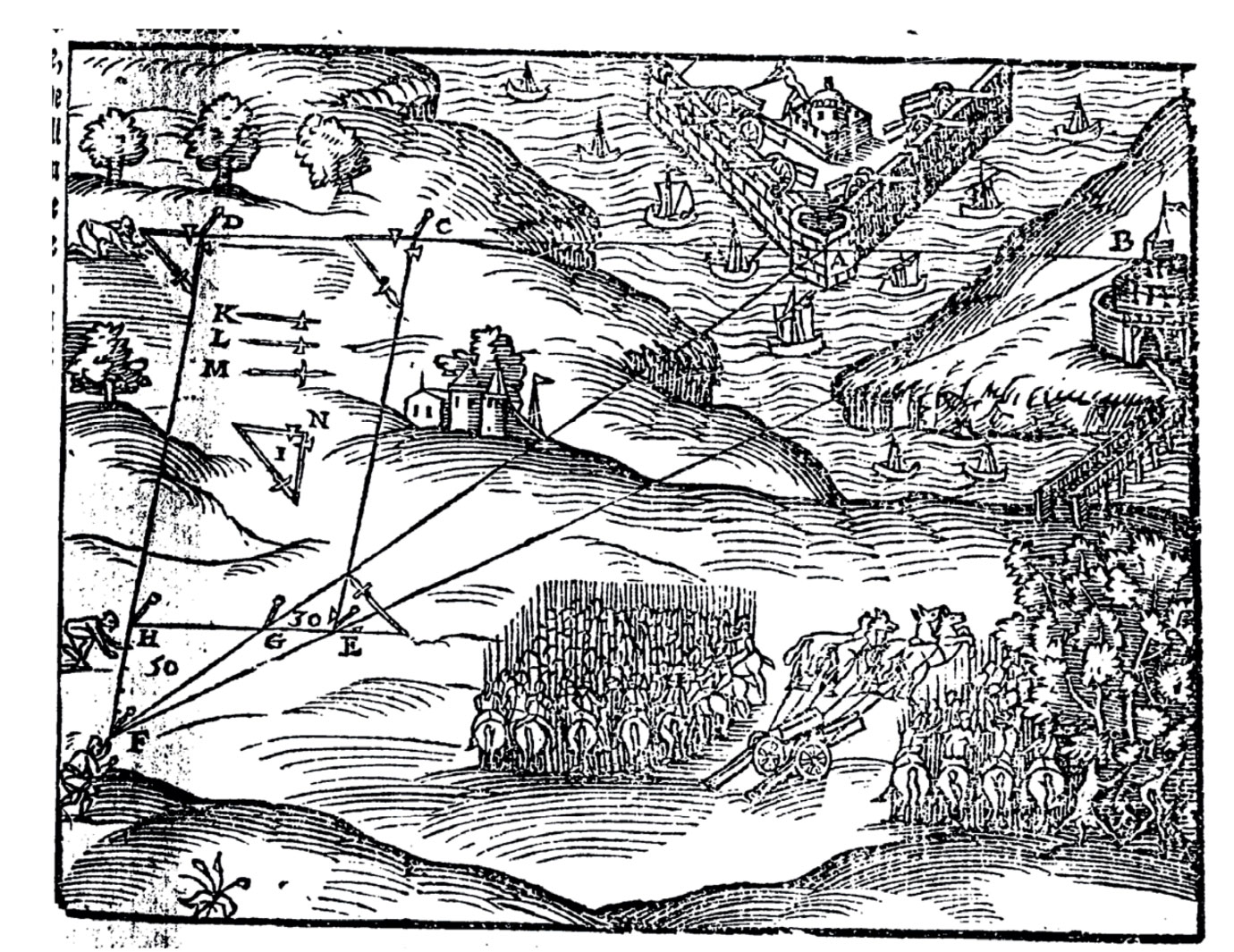
Figure 21: Woodcut engraving from Leonard Digges, Pantometria (London, Abel Ieffes, 1591) ix illustrating the techniques of landscape engineering practised in the sixteenth century and earlier. Long baseline alignments are laid out using specimen triangles pegged out at small scale on flat ground, which are then enlarged to create known geometry in the wider landscape.
Five: The Secret of Boudet’s Map
In the late nineteenth century, the priest of Rennes-les-Bains, Henri Boudet, published a very strange book entitled, La Vraie Langue Celtique et le Cromleck de Rennes-les-Bainsx. It contained a map of the area around Rennes-les-Bains, engraved specifically for the book and included as a separate insert folded inside the back cover.
A large title, reading Rennes Celtique, appears at the top in an unusual font that appears to have been devised specifically for the occasion. The design of the lettering and the size and prominence given to the heading make for an odd effect.
The map has further anomalies. There is no grid shown nor co-ordinate system displayed. Lacking any of the elements usually considered essential, including scale, grid and measure, these shortcomings render it next to useless.
Gérard de Sède addressed these questions when he reproduced Boudet’s map in his 1988 book about the Rennes affair. He commented:
“This book, at first sight ridiculous, is in fact a work of geographic cryptography. That is why it includes a map of the region.”xi
“In other words, the work is a cryptogram. We are thus invited to decipher it, that is to say to transform the apparent nonsense of the text into something meaningful. This operation presupposes the discovery of the key, that is to say the convention used by the author to carry out the reverse operation.”xii
Yet, no such key has ever been found. Boudet’s map has resisted all attempts at deciphering its mysteries for over a century.

Figure 22: Title page of La Vraie Langue Celtique by Henri Boudet (1886)
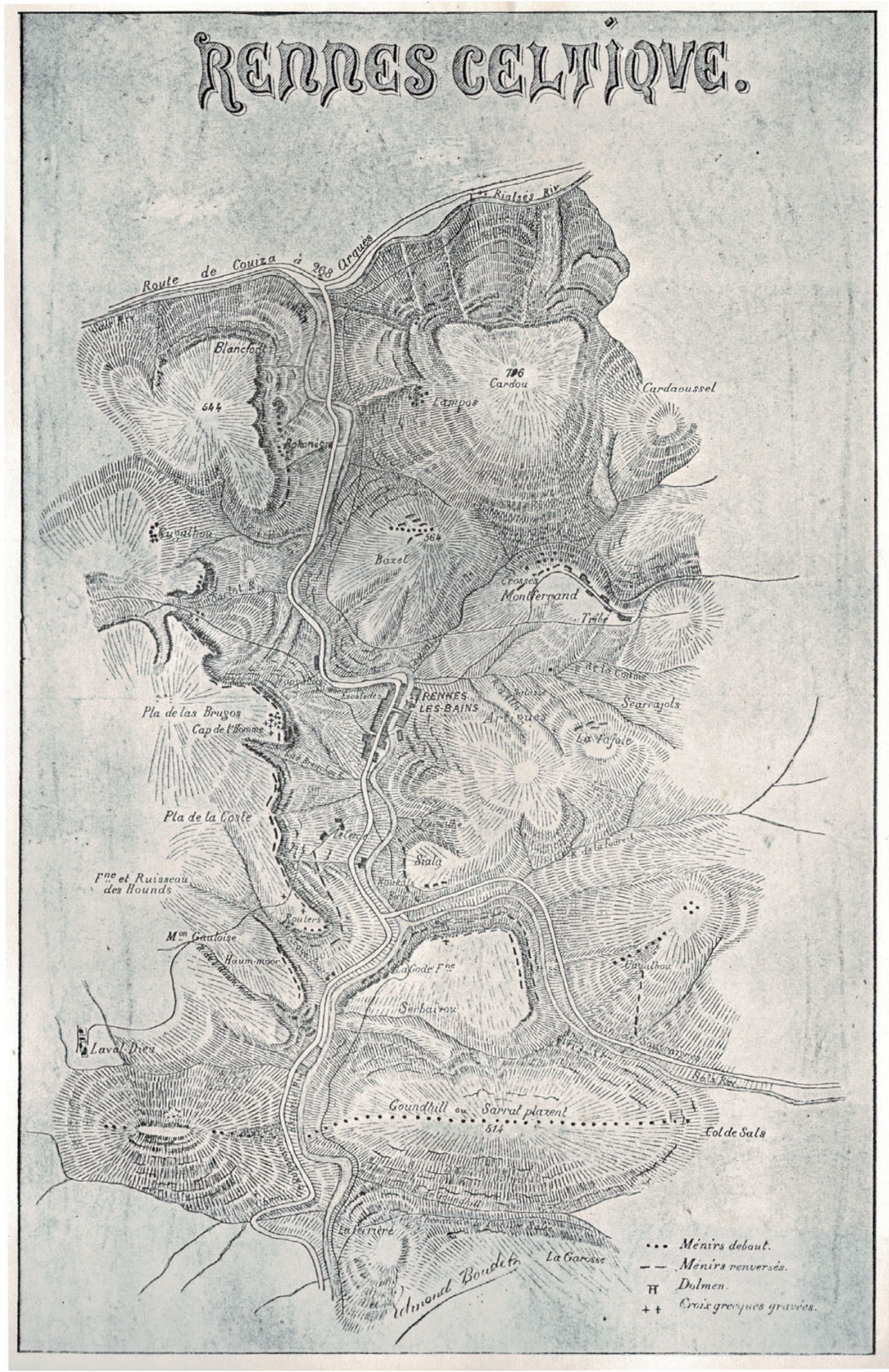
Figure 23: Map included with the original edition.
I have discovered the key, and described it in detail in The Map and the Manuscriptxiii. Here below, I share it in open forum for the first time.
The clue to unlocking the map is hidden in plain sight. The key is this: the first word of the title, Rennes, is exactly two inches in length and one-half inch in height. This is the hidden secret of Boudet’s map and his book: the measure by which the map is conceived and constructed, and by which it needs to be read, is the English inch.
The grid that is obviously missing from the map is a grid of inches, or half-inches. It aligns vertically with the left-hand edge of the title, and horizontally with the top and bottom of the half-inch-high title itself.
There are multiple unambiguous indications that demonstrate this concealed grid is an intentional design layer of the map. With the title providing our cue, we can now rule in the grid on the map. Taking the left and the top edges of the title as reference axes, we extend a grid of inch or half-inch squares across and down the map. When we do so, the first thing to notice is that the left-hand border correlates exactly with a vertical line of the grid.
We also find that the elements of the legend at the bottom right-hand corner of the map are precisely positioned on the grid. The lines of text fall on the sub-division of the inch grid into twelfths. In effect, the text functions as a kind of invisible “scale”. Exploring the map carefully with the grid made visible reveals a host of additional correlations.
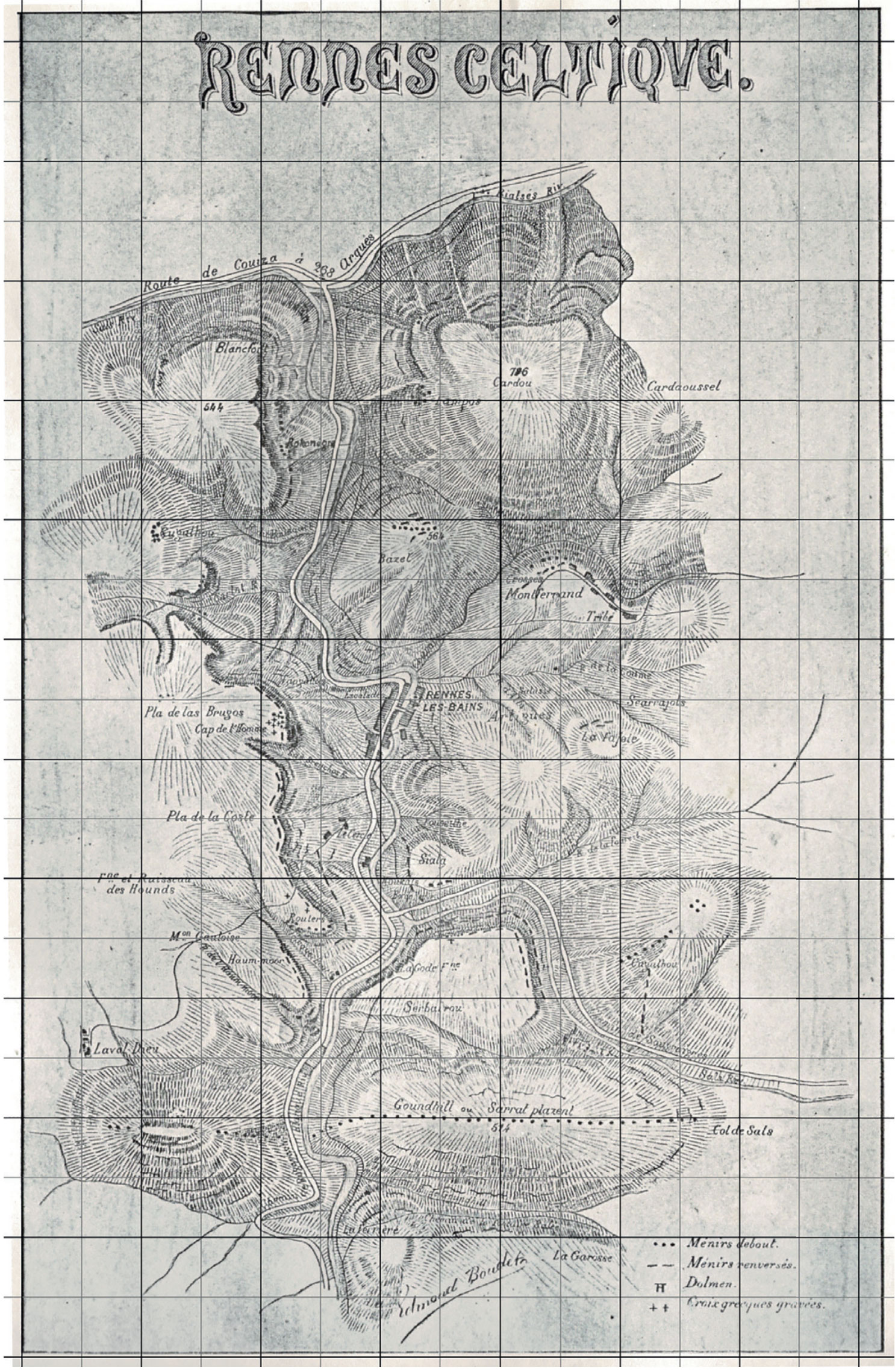
Figure 24: Boudet’s map with superimposed grid of half inches. The grid size and position has been generated using the title as the reference guide. The grid has then been extended over the full map. Notice how it co-incides with the left edge of the frame. There are numerous correlations between grid and map.

Figure 25: The secret key to unlocking the concealed inch grid of the map is deposited in the position and measure of the title. Much of the text on the map, including the Legend, aligns to this grid when further subdivided into squares of 1/12 inches as shown in the examples above.
In the Google Earth image below, the Boudet map has been superimposed at correct scale on the landscape. The three vertical red lines are the meridians of Lavaldieu, Bézu and Rennes-les-Bains. It is very remarkable that the three meridians correspond exactly with three of the grid lines on the Boudet map.
This correlation between the observed meridians in the landscape and the Boudet map, with its hidden grid of inches, is as unexpected as it is astonishing. For me, it was confirmation that the meridians that I had discovered were genuine ancient artefacts, and that knowledge of them had persisted by some means and was recorded, in encrypted form, by the priest Henri Boudet of Rennes-les-Bains in his mysterious book and map.
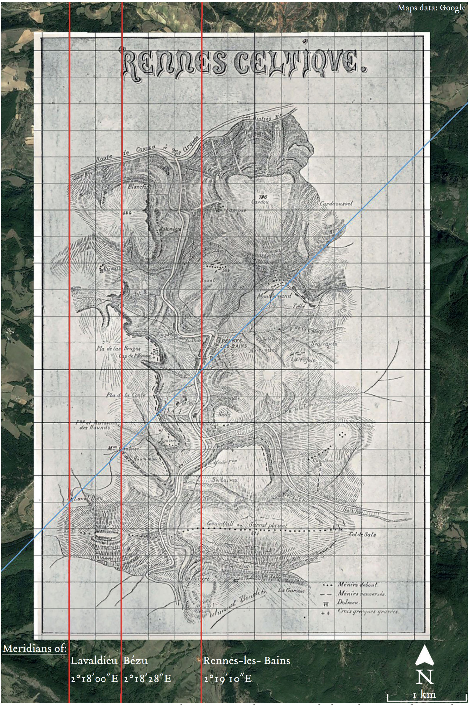
Figure 26: Superimposing Boudet’s map with its concealed grid on Google Earth reveals that the three inner meridians of Lavaldieu, Bézu and Rennes-les-Bains coincide with three vertical lines of the half-inch grid.
Summary
When I began my journey all those years ago in deciding to check for myself whether the claims of Henry Lincoln in The Holy Place were true, or not, I had no idea how far it would take me. Now, all these years later after I picked up that compact volume on a rainy Saturday afternoon in Melbourne, I have come to the conclusion that something genuine has indeed been deposited in the landscape of the Languedoc, even if the details were very different than Lincoln first imagined.xiv
It is an ancient artefact made of geometry, distributed in the landscape of this remarkable area in the foothills of the Pyrenees. I have now spent years exploring it, first on the map, and then in person, and also in Google Earth. There is much more to describe than has been presented, but perhaps enough can be seen in these images to suggest that there is indeed something of potential interest here.
In those early years, I did not consider that my investigation into landscape geometry might have any bearing on the mysteries of Rennes-le-Château and Rennes-les-Bains. Yet, to my great surprise, it has turned out to be directly relevant. The Boudet map demonstrates conclusively that knowledge of these ancient landscape forms has been transmitted in some form into relatively recent times. This insight provides the key to unlocking many further layers of the various puzzles which make up this curious affair.
These topics and much more are explored in detail in my book, The Map and the Manuscript: Journeys in the Mysteries of the Two Rennes, published in 2022 by Ignotum Press, Mossley,UK. My sincere thanks to Graham Hancock and his team for the opportunity to present my work here.
i Lincoln, Henry, The Holy Place: The Mystery of Rennes-le-Château – Discovering the Eighth Wonder of the Ancient World (1991), Jonathan Cape, London.
ii Selected books:
Baigent, Michael, Richard Leigh and Henry Lincoln, The Holy Blood and the Holy Grail (1982), Jonathan Cape, London.
Baigent, Michael, Richard Leigh and Henry Lincoln, The Messianic Legacy (1986), Jonathan Cape, London.
Documentarries:
Lincoln, Henry, BBC Chronicle documentary: The Lost Treasure of Jerusalem (1971). Available 24.6.22 at https://www.youtube.com/watch?v=rkMaGA0HDxs
Lincoln, Henry, BBC Chronicle documentary: The Priest, the Painter & the Devil (1974). https://www.youtube.com/watch?v=Uru8UiCxLnc
Lincoln, Henry, BBC Chronicle documentary: The Shadow of the Templars (1977). https://www.youtube.com/watch?v=-bYKaXJVt6k
iii Wood, David, Genisis (1985), The Baton Press, Tunbridge Wells
iv Richer, Jean, Géographie Sacrée du Monde Grec (1967), Hachette, Paris.
v Including Richer, Jean, Delphes, Délos et Cumes : Les Grecs et le Zodiaque (1970), Julliard, Paris.
Richer, Jean, Géographie Sacrée dans le Monde Romain (1985), Guy Trédaniel, Paris.
vi Richer, Jean, translated by Christine Rhone, Sacred Geography of the Ancient Greeks: Astrological Symbolism in Art, Architecture and Landscape (1994), SUNY Press, New York.
vii Rivière, Jacques and Claude Boumendil, Histoire de Rennes-les-Bains (2006), Belisane, Cazilhac (Aude).
viii De Sède, Gérard, L’Or de Rennes (1967). Translated The Accursed Treasure of Rennes-le-Château (2001) by Bill Kersey from, DEK Publishing, Surrey.
ix Digges, Leonard A geometrical practise, named Pantometria diuided into three bookes, longimetra, planimetra, and stereometria, containing rules manifolde for mensuration of all lines, superficies and solides. London, Henrie Bynneman, 1571.
x Boudet, Henri, foreword by Pierre Plantard, La Vraie Langue Celtique et Le Cromleck de Rennes-les-Bains (1886), 1978, Belfond Press, Paris.
xi Gérard de Sède, Rennes-le-Château : The dossier, the impostures, the fantasies, the hypotheses, op. cit. pp. 142, Plate C.
xii Foreword by Gérard de Sède in Henri Boudet The True Celtic Language and the Stone Circle of Rennes-les-Bains op. cit. p. xiii. p. xii.
xiii Simon M. Miles The Map and the Manuscript: Journeys in the Mysteries of the Two Rennes, (2022), Ignotum Press, Mossley.
xiv I had the opportunity and honour to meet Henry Lincoln several times during my years in the Haute Vallée, and he was always very generous with his time and gracious to me. Sadly, he passed away in early 2022.
I am a geographer who has discovered history in past 25 years. I’m always looking for reasons why settlements have been built and it is often you only realise why, when you go and see for yourself. You notice lines of sight and sometimes meridians, but they CAN often be explained by simple geology. North and South Downs in England mirror each other and with erosion at a constant rate the various ridges and valleys are today at matching heights over 100 miles apart. Man intervenes when they notice these features and therefore build their churches and castles accordingly. This may be what happened here.
However, I have done a similar exercise in my re-writing of the history of William Shakespeare – (Shakespeare Re-invented), which places the original home of the Shakespeare family at Temple Balsall – a remote place near Solihull, still undeveloped. It was only when I realised you could draw a circle around Balsall exactly 100 miles in radius that this was significant. There is a nearby village called Meriden (Middle) and the Roman roads of Fosse Way and Watling Street cross at 90 degrees a mile or so away, marked with a cross. None of these settlements are there by accident. Temple Balsall was a Templar Commanderie and the preserved manor house there still holds a Templar meeting 4 times a year. The clue here is obviously the Templars and is the same in Rennes. My book is out of print but I do have pdfs for those interested.
Does your England centre relate to the manor where the Arcadian shepherds plaque monument is? And/or to the northernmost point of Scotland?
I agree with your view of culture taking cues from nature. My comment on Miles (an appropriate name for a geo code cracker) is in the AOM Forum thread, where I hope that you would comment further.
Please email me your book PDF via contact you could see among my posts that I link to.
[I had posted my comment to Keith, below Blaine, by mistake].
I omitted to say that the 100 miles radius puts Temple Balsall at the centre of England.
“In an unexpected twist of fate, I was fortunate to end up living in France.”
Dear Sir, there are no coincidences. Bless you for following the path you were given.
Thank you for the interesting read.
Does your England centre relate to the manor where the Arcadian shepherds plaque monument is? And/or to the northernmost point of Scotland?
I agree with your view of culture taking cues from nature. My comment on Miles (an appropriate name for a geo code cracker) is in the AOM Forum thread, where I hope that you would comment further.
Please email me your book PDF via contact you could see among my posts that I link to.
Thanks Blaine for your comment and encouragement. I appreciate it.
Build it
And they will come
And here we are!
Mr. Miles,
I am thoroughly enjoying your book. I like how the the conflicts and resolutions are often the “a-ha” moments of symbolic and esoteric discovery. There’s one important left-brained and right-brained pattern that Gérard de Nerval and C. G. Jung exhibited in their birth charts: when both were born, the Moon in Taurus was in sextile to a planet in Pisces. This means that the subtle “link” as the L4/L5 Earth-Moon Lagrange Point with the Moon exalted in Taurus connects apparent creativity to planets in Cancer or Pisces, respectively–a left-brain explanation–in a very mystical and dream-like experience in life–a very right-brained experience. The Sleeping Prophet Edgar Cayce, like Nerval and Jung, shared this exact same aspect at birth. Often individuals of this nature are drawn to astrology because they literally “feel” it’s reality, furthering their demonstrative evidence materially to confirm the feeling. I touch on this in Part III “H. P. Lovecraft and the Dark Forest” article on Graham’s site. Forthcoming manuscript at the publisher’s now: “Cosmic Influences on Crime and Creativity: New England, the occult, and the Escapist Imagination.”
Lastly, also very surprised you didn’t include Jung’s Liber Novus/Red Book or Hillman’s/Shamdasani’s Lament of the Dead in your work. Shamdasani, the translator of Liber Novus (Jung’s “dream diary,” if you will–I prefer “passport to chthonic elements Jung integrated via active imagination”) touches on how really Jungian analytical psychology–what it has become after Jung’s death–seems not to be Jung’s intent.
Dear Anthony,
Thank you very much for your kind comment on my book.
Your insight about the charts of Nerval and Jung is very insightful, and points to a fascinating correlation between them. Nerval had Pluto conjunct Jupiter in Pisces, and died with the newly discovered Neptune just failing to make transit to the two planets. And with Pluto about to transit his Moon.
There’s really something to the Moon in an earth sign when the L4/L5 Lagrange Point of the Earth-Moon is also a placement of a planet sextile the Moon. The astronomy of this aspect and position only becomes astrology when theories of consciousness link. Julian Jaynes’ bicameral mind, Frank Heile’s Three-Agent Model of Consciousness, and Donald Hoffman’s split-brain research are all qualitative correspondences of this. These correspondences in the occur even to the effect of observing “The Secret of the Golden Flower”—the Chinese sacred book brought to the West by Richard Wilhelm. And as synchronicities of this nature as coined by C. G. Jung occur in oddly meaningful ways—Jung was drawn to this book and also Wilhelm—leading here to a full-circle occult influence via Edgar Cayce can be summed up from the Director of the Edgar Cayce’s Association for Research & Enlightenment (A.R.E.), John Van Auken (from his own “Edgar Cayce and the Secret of the Golden Flower: Ancient Taoism Way to Your True Self”):
“By the time I came across the Golden Flower teachings, I understood that ‘Heavenly Heart between the sun and moon’ was actually the place of my deeper mind and its view from behind my two eyes. This fit well with my study of ancient Egyptian wisdom in which the right eye represented the sun and was called the ‘eye of Ra,’ while the left represented the moon and was known as the ‘eye of Horus.’” They are all saying the same thing about “Foucault’s pendulum” as a metaphor for consciousness via Umberto Eco and they all share the same geocentric astrological occurrence at birth.
Anthony, than you for sharing that acute observation. Synchronicity is always active, but only prepared minds notice it. Psychology labels this the ‘curiosity feedback /attraction’ (or something similar) phase in research. But the human sciences have no benefit or recognition of it. They have not yet udnerstood the implication of what Eddington found among physics laws and constants; the edge or limits of knowledge. We could learn of nature only as much as perception allows. I discuss this issue in my paper Blueprint.
Mr. Miles,
If you found regularities, alignments, mathematical relations and laws, strange “coincidences” among the features that should not express those laws, be sure you are on the good path.
This and much more is to be revealed to a mankind related to a Man’s, Heaven’s, and Earth’s interactions. Micro plain reflects macro image as the Heavens too. No doubt human activity obeys mathematical laws, the language of nature.
Measures, Mercator’s system, natural and mathematical constants and laws,…, deep skies, astronomy, geography and much more were known in detail from first cultures. Evidence can be find everywhere.
Have a look at the materials below.
Good luck with your further quest.
Best,
Srđan Nogić (Croatia)
https://pleiadiangeography.wordpress.com/2020/11/20/ireland/
https://m.youtube.com/watch?v=rfUFaKspyJc
https://m.youtube.com/watch?v=Qjnzich2Xfk
This should be cross-referenced with Graham Robb’s book The Ancient Paths: Discovering the Lost Map of Celtic Europe, in the USA called The Discovery of Middle Earth. He finds a large number of lines in the landscape aligned with the solstices.