


We warmly welcome Pétur Halldórsson, author of The Measure of the Cosmos: Deciphering the Imagery of Icelandic Myth, as our featured author this month. Pétur’s book reveals how, for both practical and spiritual reasons, ancient landmarks in most civilised settlements linked their central sacred and administrative areas to both the solstice positions of the sun and multiples of cosmic numbers in the diameter of their cosmos.
Despite wide separation in place and time, all the major civilisations used the same pattern to anchor their first formal settlements to the sky. This cosmic image remains readable in the names and legends attached to landmarks in the core areas at Memphis, Jerusalem, Athens, Rome, Venice, Paris, Jelling, London, Somerset, Ireland, Hebrides, Iceland, and Washington D.C. Pétur examines the idea that the location and layout of these settlements follows a measured plan.
In his article here, Pétur explores some key markers of a land-sky connection in ancient settlements in Iceland and worldwide.
Interact with Pétur on our AoM Forum here.
Through the centuries, nations staked their claim to land by using measurements and calculations based on cosmic ratios. Setter surveys served to connect people to their land and sky, their place and time, and to higher powers. For example, our sun has a diameter of 1,392,000 km and turns on its axis every 25 days. Earth, the third planet, orbits the sun at a distance of 149,600,000 km, the exact distance that could form and sustain water-based life. The average distance from the sun to the earth is the equivalent of 108 times the sun’s diameter. Thus, the diameter of the earth’s orbit is 216 solar diameters. Curiously, these ratios are identical to the ratios humans have been using for thousands of years in land surveys to mark out landmarks around fertile plains, on the scale of 4.5 million: 1. These proportions were used at the human scale. Land survey ratios fit cosmic values long before we could check them with astronomical instruments.
Sagas Indicate A Cosmic Landscape
Research into Icelandic sagas had revealed that the first settlement in the last big ‘greenfield’ landmass, by Pagan people, followed a spatial pattern expressing cosmology, measured with exquisite geometric and numerical precision. Cosmograms project seasonal markers onto prominent landmarks. The best-preserved example of this universal human impulse is in the river delta of south Iceland. This discovery paved the way for the study of cosmograms on the horizons around older settlements in fertile pastures, where thick layers of sediment were carried by major river systems.
Viewed from the centre of civilised river deltas, the seasonal sun markers and cardinal directions form a consistent pattern, enabling an accurate day-count of the seasons and year. The same pattern and set of impulses, symbols and crafts were used again and again, from the Middle East, through Europe, ending in Iceland, with the last example in Washington, USA. Thus, Iceland offers a source of reference to reveal the layout of prehistoric settlements, calendar rituals, geopolitics, and related crafts.
My book is based on the work of the scholar Einar Pálsson, who discovered the ancient pattern of behaviour in the conceptual background of 13th Century Icelandic saga manuscripts.
A chieftain’s son of one of Iceland’s ruling families recorded his forefathers’ knowledge about world place, time and ages in an allegory that sheltered it from the temporal and spiritual authorities in the transition from Pagan spirituality to Christianity.
Points 2 to 9 below outline the key landmarks in the Icelandic settler survey cosmograms, which apply to all the more ancient ones found throughout the world, as well as a more historically recent example.
2. Bergþórshvoll – The Primeval Hill
From the centre of the Ketill Haengur river plain, the first Icelandic settlers viewed the midwinter sunset in the southwest over a hill 108,000 feet away. The geometry and orientation in the older cosmogram in Somerset in England had expressed the same model but keyed to 1 May and 1 November. In Iceland, the more usual and more obvious midwinter and midsummer solstices of 22 December and 22 June were landmarked. All cosmograms use the same cosmic ratios.
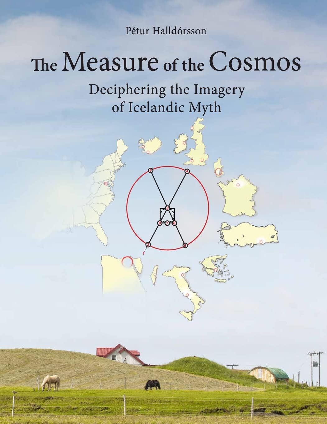
Cosmic Image from The Measure of the Cosmos: Deciphering the Imagery of Icelandic Myth p 28
South Iceland latitude 64°N:
- Horizon, Þrídrangur: Alignment anchor
- Bergþórshvoll: Midwinter solstice sunset
- Center, Steinkross
- Stöng: Midsummer solstice sunrise
- Goðastein: Midwinter solstice sunrise
- Skálholt: Midsummer solstice sunset
- Helgafell: South orientation
- Mt. Triangle: SEast orientation
- Hof: SWest orientation
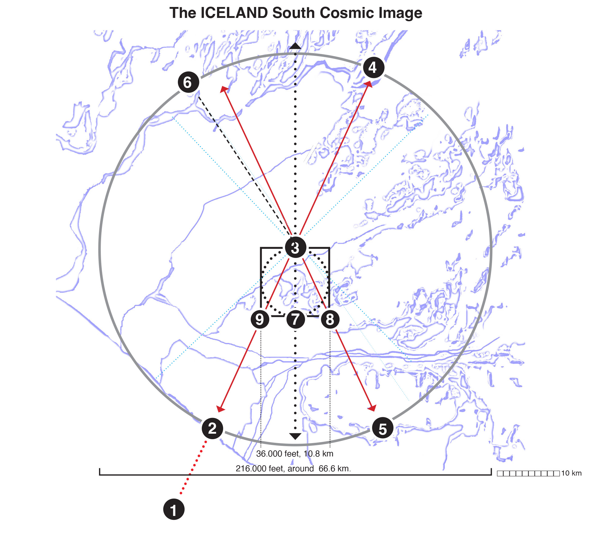
Cosmic Image from The Measure of the Cosmos: Deciphering the Imagery of Icelandic Myth p 28
Somerset, England 51°N:
- Horizon, Burrows Mump
- Glastonbury
- Devil’s Bed & Bolster: The Center
- Avebury
- Stonehenge
- Bristol
- Heaven’s Gate
- Robin Hood’s Bower
- The Bushes
At the time of the settling of Iceland, Pagan traditions had millennia of heritage, including cosmograms nestling in civil landscapes all over the Mideast and Europe. Cosmograms underlie many European megalithic landscapes. Somerset’s major landmarks stand on a basic cosmic grid, suggesting the usual measured plan. The distance between Glastonbury and Avebury, across the centre at Devil’s Bed and Bolster, is 216,000 feet, about 66,000 m. The orientation is within the slightly wider sun watch of the four seasonal landmarks.
The distance from Stonehenge to an old burial mound near Bristol International Airport is also 216,000 feet, about 66,000 m, also across Devil’s Bed and Bolster, itself an old elite burial ground. South from this centre, about 10,800 m towards the noon sun, is Heaven’s Gate, serving as the inner field south marker, 36,000 feet away, or 6’ minutes of earth’s circumference.
Icelandic settlers at the estuary of Rangárvellir also used this diameter, based on 216,000 feet or 360 stadia, the last of its kind. Their landscape features were set down as part of a 12th Century allegorical tale, Njál’s saga, after AD 1000, incidentally later protecting their sacred landmarks from Christianity.
Cosmograms in Rome, Paris and Athens
The same cosmogram was surveyed at Jelling in Denmark, St. Denis in France, Rome, Marathon in Greece, in the Thames estuary of London, including Marble Arch and The Tower, in Somerset, Tara in Ireland, and lastly at Bergþórshvoll in Iceland. Smaller-scaled cosmograms were found in the Vatican City. The same basic calendar and survey model could be used to compare all these markers, and the legends attached to them.
The roots of Icelandic culture lie in European societies. The first Icelandic settlement followed the same basic principles. Direct comparisons imply that geometry, numerology, historic sites, and religious ideas remain linked to the path of the sun, moon and stars, with only the angles differing due to latitude. Iceland’s high latitude causes the widest sun watch of all.
Rome’s river plain was measured in the same way: 108,000 feet inland from the sea is its centre. Its old central field borders include the Etruscan burial ground of Settebagni. Rome’s harbor and its winter sunset Primeval Hill is Isola Sacra, and its winter Far Horizon or Triple Rock is at Lido di Faro.
Cosmograms in Paris and the Holy Land suggest the same survey model was used. Some diameters varied to accommodate natural landmarks. The ‘Triple Rock’ of the Paris cosmogram seems to have been marked by the triangular castle of Rambouillet, outside the measured diameter. The Triple Rock of Jerusalem is the triangular fortress of Lachish, outside the measured diameter. Lachish is pictured on the walls of Sennacherib’s palace at Nineveh, clearly showing its triangular shape. 3
Land and Body as Microcosms
In many settlements, the basic area survey unit was 360 stadia, or 216,000 feet. Survey ropes could have been 190 feet (about 57 m), short enough to hold up between two surveyors, aligned by a third observer.
Most cosmograms were surveyed for agriculture and admin. Sectors of land were based on the length of ox furrows. Plows were hard to turn around, so furrows were made a uniform length. A furlong became 40 x 4 rods, equal to 660 x 60 feet. Eight furlongs make a mile. Three miles make a league or 15,000 feet. Twelve leagues make 180,000 feet, the distance a healthy man could walk in a day. Adding the sacred center square field’s 36,000 feet to 180,000 feet, equals the outer diameter of 216,000 feet.
3. Central Field Markers
The settlements of Ketill Hængur in Iceland, and in the Holy Land around Jerusalem, have similar landmarks, geometry, numerology, calendric and religious uses. Seen from their central vantage point, they link the annual path of sun and moon risings and settings to the economy. The New Testament makes an intriguing statement about Jerusalem having the measure of a cube with the dimensions of 1728. In John 21, an angel measured the holy city with a golden rod: 12,000 x 12,000 x 12,000 stades, a cubic volume of 1,728,000, or 216,000 x 8. This cubic format compares with the Old Testament’s Ark, and the Jerusalem Temple’s Holy of Holies, or Dbir, with its dimensions of 6 x 6 x 6, a cubic volume of 216, a smaller scale of the 60 x 60 x 60 =216,000 feet of the civil landscape.The central point of cosmograms was a place of gathering, elite burials, and a vantage point to check time, distance, and natural and cultural laws. The outer border was 108,000 feet in all directions, about 33 km. The central square field of 36,000 feet always lay south of the centre, towards the noon sun. This geodesy is common to many cosmogram centres:
-
Memphis area in Egypt.
-
Steinkross area in Iceland.
-
St. Denis near Paris in France.
-
Nekrotafeio cemetery in Athens, Greece.
-
Jelling area in Denmark.
-
Fingal’s Cave north of Iona in the Hebrides Islands.
-
Tara Hill area in Ireland.
-
Devil’s Bed & Bolster in Somerset, southern England.
-
Coppett’s Wood at St. Pancras in Islington on the Thames Delta.
-
Etruscan Settebagni in Rome.
-
Har HaMenuchot Hill and the area around Jerusalem.
-
The Pope’s altar over St Peter’s crypt, (East) on a smaller scale.
-
King Athelstan’s domain in England.
King Athelstan’s Perfectly Measured Domain
Egyptian Pharaohs were living symbols of the measuring rod or Maet, or Maat. One of the roles of kings in Europe remained the same. Royal domains were models of units of measurement and centres of administrative order. A manuscript of the time of King Athelstan of England, who ruled at the time of the settlement of Iceland in 874 C.E., records the laws providing for the king’s holy verge or domain. It was to be measured from a centre to an edge at 3 miles, 3 furlongs, 9 acres, 9 feet, 9 hands, and 9 barleycorns. The total makes a radius of 18,000 feet, or a diameter of 36,000 feet.1
This is the same number as the sides of the central fields in many lands. His laws included all the units of measure in decreasing order, in multiples of threes and nines. That law was not just a practical measure, but a sophisticated allegorical symbolism. Athelstan’s royal surveyors may have inherited their numerology from his grandfather, King Alfred. Nevertheless, the geodetic survey model was sustained by our impulse to stake a claim to all the dimensions of nature and culture, which are crucial in agriculture and pastoralism, even in hunting and gathering territory.
The Human Landscape
Rescue teams still use the concept of distance today, as stated in the U.S.A. Coast Guard Addendum to the Rescue Supplement.2 According to the International Search and Rescue at Sea Procedures, involving RFF antenna heights and human sight (section 10), a visible horizon on flat terrain is 18,000 feet (about 10,800 m). This is the same distance as the radius of surveyed central field cosmograms. The cosmogram diameter could be paced out in 12 hours, covering 3,600 furlongs, or 360 stades, or 216,000 feet, or 180,000 + 36,000 feet.
4. Summer sunrises over Stöng, ‘Rod’
In Iceland, the landmark under two summer sunrises, at the start of summer and middle of summer, is named after a measuring rod. Summer ‘deflowers’ the land by turning flowers into fruit in the myths of European and Indo-European cultures. The two days when the sun rises behind Stöng have two related symbolic meanings: conception, and birth or re-creation.1
The Icelandic annual re-creation was paced out from the winter hill at Bergþórshvoll (Iceland South Cosmic Marker 2) to Stöng (Iceland South Cosmic Marker 4), where the first fruits of the season were harvested and sacrificed. A rod or stöng was planted 216,000 feet from the primeval hill. In the Thames estuary, the ‘rod’ site is at Rodings. In Greek culture, rod sites were marked by a Herm, a standing stone with erect male genitals. The ‘rod’ of Athens is at Marathon. In Paris, the rod site is at (H)Ermenoneville, named after Hermes, probably a former Herm site.
Somerset’s Rod
The ‘Rod’ or ‘Stöng’ of Somerset lies north-east of Glastonbury Tor, across the Center at Devil’s Bed and Bolster, with a slight deviation in angle to sunrise on the Gaelic May Day about 1 May, or 40 days after the spring equinox. The Tor is 108,000 feet from its cosmogram centre, with its last stretch along a cairn-lined boulevard named Beckhampton Road, leading to the two small stone circles inside the massive Avebury circle, perhaps identified with sun and moon.
Rome’s Rod
North-east of Rome lies Monte Sabine, in the Sabine Mountains, also a ‘Rod’ site. Roman creation myth notes that the tribes which settled the Apennine peninsula had come from Alba Longa city, built by King Ascanius somewhere in the Tiber River delta. When his family had reigned for 400 years, the king’s brother, Amulius, killed the rightful prince and confined his sister to chastity for life. But she fell pregnant by the god Mars and gave birth to the hero twins, Romulus and Remus. Usurper Amulius ordered them drowned in the river, but the executioners disobeyed that order and placed the brothers on a raft on the river. The river god gave them to a she-wolf to raise on an island. They grew up and reclaimed the kingdom. Two tribes were most prominent in the Tiber region: the Sabines, and a small group of Romulus’ followers on the Palatine Hill. To beget offspring, the Romulans invited the Sabines to a feast. While the Sabines ate and drank, Romulus’ men raped the Sabine women, who bore them children, the first Romans. The Sabine Mountains are named after the Sabine tribe in their foothills. Romulus’ conception feast site was near the amphitheatre, Anfiteatro Romano di Trebula Mutuesca, in Monteleone Sabino. Under summer sunrise, the site is 108,000 feet from Settebagni in Rome, and 216,000 feet from Rome’s Winter Hill at Ostia Antica harbor on Isola Sacra in the Tyrrhenian Sea. From this island, 216,000 feet, northeast over Settebagni, the quarter-day seasonal axis lies on 43° to Monteleone, over the vineyards and distilleries, where the first Romans were allegorically conceived.
Athen’s Rod
Marathon, northeast of Athens in Attica, is famous for its battlefield where Persians came ashore and were defeated by the Greeks in 445 B.C.E. Here, the sun conquered darkness in allegory, as in the first marathon run by the slave Pheidippides from Marathon to Athens to herald the Greek victory. That messenger’s symbolic run followed a cosmogram’s ‘Rod’ line to the centre of a sun watch at Athens’ first cemetery, near the Acropolis. Olymbos lies southeast, and Levka, or ‘White’, lies northwest, 5 and 6 on Athen’s map (Measure of the Cosmos p66). A marathon is about 108,000 feet, walkable in a day, but difficult to run. The marathon run of Pheidippides is probably mythical. There is no mention of this achievement in the 5th Century B.C.E. account of the Battle of Marathon by Herodotus. But the Marathon run appeared in annals for 600 years after the event, and became an Olympic event. Today, the suburbs of Athens reach all the way to Marathon. The famous clash between Greek and Indo-European cultures, and the Greek victory over Persia marked a turning point in history, laying the political foundation of the Western world. Athens became the Greek and Mediterranean capital at the dawn of the Classical period, nurturing arts and sciences as never before. The end of the Persian wars confirmed the global dividing line between Europe and the Middle East. Cosmic sites attract global events.
Jerusalem’s Rod
After the Exodus, the Israelites settled in the Canaanite hills west of the Dead Sea. The neighboring tribes worshiped the sun and monitored its rising and setting on the horizon from their hills or ‘high places’. In Hebrew cosmography, Gilgal symbolized the summer sunrise and the solar year as seen from the sacred centre at Har HaMenuchot. The Israeli cosmography was measured 216,000 feet from its winter sunset or Primeval Hill at Bayt Jibrin, 108,000 feet from the centre. The Bible mentions Gilgal or ‘Circle’ as a place near Jericho, where a stone circle remains, as it also remains at Avebury.
The Rod in South Iceland
In southern Iceland, under a layer of ash from Hekla’s eruption in 1104 C.E., lies the ruins of the farm named Stöng or ‘Rod’ in old annals, one of the island’s famous Medieval relics. It was newly built when it had to be abandoned due to the volcanic eruption. But under it, thousands of older relics were found, including a stable, barn, burial site, and what seems to have been an iron smithy. These deeper layers have not yet been excavated. Behind the main house was a large storeroom with big vats, suggesting a meeting on this landmark of two sunrises, at the start and at the middle of summer.
5. Winter’s Sunrise Over God’s Stone
Mythical Óðin is one-eyed, having traded an eye for eternal wisdom from the Well of Mímir. Now, one eye shines at any time, the moon by night, the sun by day. Óðin’s Valhalla is described in cosmic terms in Grímnismál verses 23 and 24: “These 800 warriors of light emerge from 540 doors to fight darkness”. And 800 x 540 = 432,000, or twice 216,000, two cosmogram diameters.1 The verses read:
“Five hundred doors and forty more, I think there are at Valhalla;
eight hundred warriors exit through each door, when they go to slay the wolf.
Five hundred floors and forty more, I think there are at Bilskirnir;
of all the roofed houses I know of, my son’s is the greatest.”
Ages of 216,000 years
The saga’s imagery mirrors the cosmic law of the World Ages, which is embedded in cultural media worldwide. Ages are also in the myths of Persia and India. The grand rhythm of the cosmos is noted in Hindu segments of years as days in the life of Brahma, in 2, 4, 6, and 8 multiples of 216,000 years.2 These numbers raise Valhalla to the status of perfected creation. The symbolic cosmogram diameter of creation is also in the idea of Miðgarður or Middle Earth.
The Danish cosmogram is double the usual diameter, at 432,000 feet from the mouth of the Ribe River to Aarhus, and from Winter sunrise at Odense to Trehöje on the west coast of Jutland. These two axes cross at the Centre of Jelling. The vitality of New Years and New Ages also resides in the five-fold energy of Óðin’s spear.
In the southern Iceland Rangárvellir plain, the 22 December sun rises over Dagmálafjall, ‘Daybreak mountain’, but there are two winter sunrises over Goðastein, ‘God’s Stone’, at 45-day intervals, around 29 November and 14 January, as seen from the centre at Steinkross.
6. A Summer Marker at Skálholt, ‘Pot Hill’
Midsummer’s Day on July 26 (not to be confused with midsummer solstice day, June 22), 216 days from midwinter, or Christmas, in Iceland, divides the year into two parts around midwinter: just less than 216 days from the winter solstice sunset, and just less than 150 days from the summer solstice. In the mind of a scribe, Skálholt, at 216,000 feet from the Centre, by cosmic law, implies that a day was equivalent to 1,000 feet. Skálholt stands 108,000 feet from the sun watch centre at Steinkross, a stone later sacred to St. Peter, whose name means ‘Stone’. On the quarter day, May 15, or 50 days after Easter, Whitsun sunset was behind Skálholt. And 72 days later, the late summer sunset fell behind Skálholt again.
Rome’s summer sunset marker was at the first Papal city, outside the Vatican City, the archaic quarter day edifice of Sutri, 7 km north of Rome’s summer sunset landmark. The site was donated to Pope Gregory II by the Lombard King Luitprand in 728 C.E. In the Middle Ages, it had become one of the biggest cities on the Apennine peninsula, named Patrimonium Petri, Sacred land of St. Peter, 108,000 feet from Rome’s cosmogram’s centre at Settebagni. Like Skálholt in the cosmogram of Ketill Hængur in Iceland, this spring sunset landmark was also a bishop’s land.
7. Field South Borders in Jerusalem, Iceland, Washington
Helgafell, a small mountain on the Snæfellsnes Peninsula of Iceland, lies 36,000 feet due south of the Centre at Steinkross. In the Holy Land, Bethlehem is 36,000 feet south of Har HaMenuchot, the hilltop burial ground at Jerusalem’s western edge marking the sacred centre of the Holy Land’s cosmogram.
Washington and L’Enfant´s diamond-shaped region around Washington designated the District of Columbia, bears the same name as the Celtic surveyor Columba. That name is attached to surveyors from Greece to Iceland in the Old World. Washington’s border was twice the size of the central fields of Europe’s cosmograms. The survey in DC ran south from the North Boundary Stone at Silver Spring or Blairs Circle to the White House, again 36,000 feet. Washington’s diagonals lie north-south, probably after the shape of the astrolabe, a survey and navigation instrument.
The central field south border marker is important in myth. South is towards the culmination of sun and moon, and of bright southern stars, notably Sirius, opposite the North Star as the Eye of Mímir, or the World Mill, around which the firmament revolves.
In France, King Louis had issued a directive to the scientists of his new Academy to design a new system of earth measurement to be used by all nations. In this action, he took on the same role as a Columba, and as an Icelandic chieftain’s son in 12th-Century Iceland, who preserved ‘his’ culture in allegory. Njál’s Saga combined pagan crafts in a story that survived many generations. Ironically, every culture used cosmic surveys. The metric system was also successful in integrating space and time, nature and culture, in metric 10s. The 12s and 60s of the more versatile systems remain in several countries.
Among the civic settler cosmograms with well-marked central fields are:
- Helgafell, Iceland, 36,000 feet or 6´minutes of earth circumference south of the symbolic centre at Steinkross.
- Salzano, an old ritual centre in northern Italy, has a church bell tower at 36,000 feet or 6´minutes south of the symbolic burial ground of the sacred centre of the Po River basin at Morgano.
- Lysholt, in Denmark, is 6´ minutes or 36,000 feet south of the royal burial ground of Jelling, the sacred centre of the Danish cosmogram.
- Heaven’s Gate in Somerset is 6´ minutes or 36,000 feet south of the ancient cemetery and the centre of the regional cosmogram at Devil’s Bed and Bolster.
- Marble Arch in London is 6´ minutes or 36,000 feet south of the old cemetery at St Pancras, Islington, under Coppet’s Wood Hill, the sacred centre of the London cosmogram.
- The Observatory in Paris is 6´minutes or 36,000 feet south of the old royal burial ground at St. Denis, the sacred centre of its cosmogram.
- San Lorenzo fiuri la Mura on Monte Sacra, or ‘Basilica of St Lawrence outside the Walls on Sacred Mountain’, is 6´ minutes or 36,000 feet south of the ancient Etruscan royal burial ground at Settebagni, the sacred centre of the cosmogram of Rome.
- The stairway into the crypt inside St Peter’s in the Vatican City in Rome faced west, 36 feet from the grave of St Peter, the sacred centre of the cosmogram inside the sacred building, on a scale of 1:1000 to the landscape cosmogram around Rome.
- Memphis, Egypt’s royal burial ground and the sacred centre of the Egyptian cosmogram, faces northward (instead of the usual southward), 60,000 royal cubits from Heliopolis.
- Nekretofeio in Athens, the sacred centre of the Greek cosmogram on Kalithea Hill, faces north, 6´ minutes or 36,000 feet from Agioi Anargyroi-Kamatero, the symbolic north edge of the sacred field.
- The Church of the Nativity, Bethlehem, is 6´minutes or 36,000 feet south of Har HaMenuchot, the sacred centre of the Holy Land’s cosmogram.
Many place names on the central points of cosmograms reflect the concept of sacred burial and a way to the afterlife, as noted in Icelandic parchments. The two central field north-south meridian markers are usually 36,000 feet apart.
Central Field of Earth Under Heaven
In Christianity, Saint Lorenzo was the guardian of the symbolic Centre. The Cube of 6 x 6 x 6 indicates the earthly assets of the state and church. The church San Lorenzo fuori le Mura was designed to embody the foothills of Monte Sacro in the Roman cosmogram. This idea was apparently recast as a Christian symbolic tale about the union of the earthly world of man and the divine world at Helgafell.
8. Þríhyrningur
Mount Triangle, or Þríhyrningur, is 18,000 feet east of Helgafell’s summit (Iceland South Cosmic Marker 7). During spring and autumn equinoxes, midway between the summer and winter solstices, the sun will rise behind Triangle Mountain’s northern summit for three consecutive days. This spot is laced with mythic symbolism.
The first settler under Mt Triangle was Starkaður, son of Börkur Bluetooth Beard, who was the son of Þorkell Tied-Leg. Several men were named Bluetooth in Nordic myth: Danish King Haraldur Bluetooth Gormsson, to whom the learned nobles of Oddi traced their ancestry. Alleged genealogies of the Icelandic settlers suggest Danish customs. Starkaður’s wife was Hallbera, daughter of Hróald the Red and Hildigunnur, who was the daughter of Þorsteinn Cock. At their Mt Triangle landmark farm, Starkaður and Hallbera raised three sons, Þorgeir, Börkur, Þorkell, and their sister Hildigunnur the Healer. The three brothers were obstinate and unruly, craving material gain. Their materialism is a symbol of the Central Field.
9. Hof
The ninth and last surveyed cosmogram marker is the central field’s southwest corner. In Iceland, it is named Hof, ‘Temple’ or ‘Court’, the manor of the settlers’ law-giver Ketill Hængur, ‘Kettle of Salmon’. This site is often dedicated to religious or civil law and order, such as St. Cloud in Paris, Court House in Washington, DC, the Vatican in Rome, Pireas in Athens, and Saqqara in Egypt.
The first land survey in Iceland probably started by defining a sight line from the winter solstice sunset to the summer solstice sunrise half a year later. Then, from the winter solstice sunrise marker, it moved to the early summer sunset mound at Skálholt.
At Hof, the surveyors probably took a well-earned rest and called their leaders and priests to conduct rituals to sanctify their legally and spiritually ordered region. The lawgiver logically made his abode at Hof. In the delta of south Iceland, the character of Mörður became the symbol of law and order. He was probably modelled on a real ancestor, buried in Marðar Mound at Hof. Many other cosmogram courts can be found in India, Sumer, Egypt, Athens, Paris, Rome and England.
Civil Order
Numerous indications suggest that before an unoccupied region was settled, it was surveyed to a particular geometric pattern, symbolizing ideological creation and the basic laws of place and time. A close study of visual art, emblems, rituals, calendars, legends, myths, history, place names, and modern maps reveals this pattern, raising it to conscious study. The settlements in Iceland and Washington D.C. were the last to be surveyed according to Pagan tradition.
Er að fá doktor við Moskvuháskóla. Doktorar virðast sammála Bretum og Pútín. Frábært hjá þér að vanda. Sennilega þyrfti að kanna landnámsristurnar sérstaklega. Skv. því sem ég hef fregnað er uppgröftur á stöðumm víða. Skýrt út með þessum fræðum. Kem heim í sumar. Lít við í Lífsspekifélagið.
Kærar þakkir Erlingur. Til hamingju. Gangi þér vel.
Petur
Comments on this article have moved to the AOM page, under the link ‘Engage with the author here’.
Dear Petur, I have bought “The measure of the cosmos” however I have not been able to locate any manuscript as per your reference please? : “A manuscript of the time of King Athelstan of England, who ruled at the time of the settlement of Iceland in 874 C.E., records the laws providing for the king’s holy verge or domain. It was to be measured from a centre to an edge at 3 miles, 3 furlongs, 9 acres, 9 feet, 9 hands, and 9 barleycorns.”
Kæri Petur, ég hef keypt “Mál alheimsins” en ég hef ekki getað fundið neitt handrit samkvæmt tilvísun þinni vinsamlegast? : “Handrit frá tíma Aðalsteins Englandskonungs, sem ríkti við landnám Íslands árið 874, skráir lögin sem kveða á um heilaga jaðar eða lén konungs. Það átti að mæla frá miðju til brúnar. í 3 mílur, 3 furlongs, 9 hektara, 9 fet, 9 hendur og 9 byggkorn.”
Dear Jez Taylor, thank you.
On page 48 in The Measure of the Cosmos is L.C. Stecchini’s reference to the Standard Collections of Medieval English Laws about the kings holy verge:
Livio Cattullo Stecchini Appendix in Peter Tompkins 1971, Secrets of the Great Pyramid, p. 344.
Dear Petur, many thanks for the clarification. I will endeavour to get Tompkins work. Thankyou