


Sir William Mathew Flinders Challenge
Sir William Mathew Flinders Petrie observed in the 1920’s that there were definite connections between ancient Egypt and southern Russia, more particularly with the Caucasus.
In 1924 he wrote: “A fundamental change has come over Egyptian archaeology with the discovery of the earliest civilization yet known, which appears to be akin to the Solutrean. The remote district of Badari has now entered into the archaeological literature as the seat on the Badarian culture, of a high type in its pottery and ability to glaze, and well advances in figure working. Moreover, this is clearly the basis of all the following prehistoric civilization of Egypt; it forms part of the continuity of civilization in that land. If, as appears, this is derived from the same stock as the Solutrean culture of Europe, it must have travelled down from the Caucasus region, for the Solutrean work passed north of the Black Sea into Austria Poland, and Northern France without developing on the Mediterranean. Hence the groundwork of the Egyptian civilization –planted on an African people – is from the Caucasus; with it presumably, arrived a strong stock of people who brought it , as a mere trade influence could not be supposed to travel so far with such fundamental effect on most arts.” ‘Ancient Egypt’, December 1924
Exploring the ancestral origins theory further Flinders Petrie, in consultation with a Canadian Scientist – Professor Reginald Fessenden, analyzed the Egyptian Book of the Dead to determine its possible geographical origins. In his paper on ‘The Origins of the Book of the Dead’, he notes that the Egyptian mythological landscape of correlates direct with the geography of the Caucasus as described by Ptolemy. Given such remarkable literary and philological evidence Petrie concluded
“It appears, then, that the cultural connections of the earliest Egyptians, as well as the physical descriptions in their mythology, point to the Caucasus region. When, further, we find there the names of the principal places of the mythology in their relative positions, it gives strong grounds for regarding that region as the homeland of the earliest civilization of the Egyptians”. (Ancient Egypt, June 1926).
Subsequent archaeological investigation by Dr. Margaret Murray, a colleague of Flinders Petrie, demonstrated cultural similarities between the regions that included: a) The Egyptian three headed god ‘Ash’, whose heads include a lion, vulture and a snake having an identical counterpart in a Scythian deity; b) seated XIIth dynasty female figurines are similar to those found in the Tripolye culture found in Southern Russia on the Dneiper, as are : c), doll like ‘soul houses’ found as grave goods. Antiquity 15. 384 –386. Connections Between Egypt and Russia. (Gloucester, 1941)
Unfortunately due to the Bolshevik Revolution and the closure of Russian territories, it became impossible for western scientists to investigate Caucasian links with pre-dynastic Egypt. But in addition to this, with the rise of Nazism, it further became politically incorrect to consider a superior people or race invading the Nile Valley. These realities and an inherent bias in the archaeological community against Petrie’s theory all militated against scientific consideration of ancestral Caucasian connections.
It seems then that the archaeological community simply forgave Sir William’s eccentricity and just ignored his conviction of the probability of Egyptian ancestral origins in the Caucasus. Margaret Murray however was an exception and stated: ‘Archaeological evidence in support of that claim is, however, coming in by slow degrees, and it seems probable that in time the evidence will prove that the founder of the science of Archaeology was right in his conjecture’. However, since the first half of the last century it seems that no serious studies were carried out to look for predynastic cultural connections.
Perhaps if earth scientists can confirm Eurasia was indeed flooded during and at the end of the last Ice Age, thereby potentially facilitating millennia long maritime connections between Transcaucasia and the Mediterranean, then this might kindle academic interest into actively seeking ancient cultural links between the two regions. If found, then this would surely exonerate Flinders Petrie’s eccentricity and confirm his conjecture.
Background.
Azerbaijan has long been known as the Land of Fire, but few realize that it has actually been subjected to massive floods in the past so creating a geography that was very different from what we see today. With the Caspian Sea level at 28m below average sea level, (b.s.l.) it is almost impossible to imagine an upper elevation of around 225m above sea level (a.s.l.) and a massive inland sea. And yet this is what strandline evidence reveals. This great flood most likely happened some 18ka to 16ka BP at the end of the Ice Age during deglaciation and cannot be explained by glacial melt water alone.
Geologists are aware of raised terraces in excess of 100m, though these have been attributed to tectonic or mountain building uplift of the Caucasus. Personal investigation however suggests that this is incorrect, and that several flooding factors had to be involved in the creation of the drowned landscape features.
Understanding Azerbaijan’s flood events has been a fascinating and complex study and may even provide explanations for legendary prehistoric flood stories in the Ponto Caspian region. A huge inland sea and associated waterways may also provide clues to the solution of other enigmas such as the large language diversity across the Caucasus. There would also be many more implications as a large body of water would have greatly affected regional climates, regional biogeography and human demographics. It also suggests that intercontinental navigation from the Aral Sea to the Marmara Sea / (almost the Aegean Sea) was possible for millennia in the late Pleistocene. If so, flooding and the eventual disappearance of the waterways will have influenced ancient human life and helped shape prehistory. Intriguingly, the flooded landscape may even be recorded, both directly and indirectly in the rock art of Gobustan.
Interest in Caspian Sea levels began with a visit to Gobustan in April 2000 and viewing the fascinating Stone Age rock art which accurately details the life and times of these ancient inhabitants. Amongst the petroglyphs were a number of boats dating back some 8000 to 9000 years BP showing multiple oarsmen. These hinted at higher sea levels and the possibility of long distance navigation. Indeed, the boat petroglyphs attracted the attention of Thor Heyerdahl, who had a lifelong passion for exploring mankind’s ancient migrations. Unfortunately like other archaeologists and scientists he was at a loss to understand the importance of the vessels particularly as the Caspian Sea is understood to be last connected to the Black Sea some 11,000 years ago. With the Caspian Sea some 4.5 km distant from Gobustan rock art reserve and textbooks informing that over the past 10,000 years the Caspian did not reach any higher than minus 20 m b.s.l., something was not right: there had to be missing pieces to the puzzle. Indeed trying to work out must have happened is like finding bits of a jigsaw puzzle (evidence) and trying to assemble a picture with no clear idea of what the big picture might have looked like. The story is far from complete but an image has emerged that in my mind begins to challenge current understanding of events during and at the end of the Ice Ages.
For example, the presence of mysterious carved channels called ‘cart ruts’, near Baku which are very similar to those found in Malta and indeed throughout the Mediterranean region. Cart ruts are a feature of a Neolithic maritime culture. This raises the question of possible connections between the Mediterranean and the Caspian Sea. (Gallagher, 2002)
These enigmas called out for investigation and became an absorbing and wide ranging study. Looking into geomorphological, biological, archaeological aspects has revealed a story of epic proportions. In order to make sense of the terraces and strandlines it has been necessary to consider factors in additon to glacial meltwater, such as diverted Russian rivers, glacial dam collapses in the Altai region and even the influx of water from the Arctic Ocean. From geomorphological evidence (terraces and strandlines) it is clear that momentous events took place and need to be explained. This article aims to present a range of information that considers different events from current scientific understanding. The interpretations may turn out to be wrong, but the ideas are amenable to scientific and academic investigation.
Introduction
Fluctuations in the level of the Caspian Sea have greatly influenced coastal communities for millennia. This is due to the dynamic balance between regional climate, temperature, rainfall in the catchment areas of the rivers feeding the basin (principally the Volga), and evaporation from the surface of the sea. As an endorheic basin (i.e., having no outflow), water level will either rise or fall depending on climate and rainfall.
In the present era, fluctuations are only of the order of a few meters, and while significant to those living near the coastline, variations are minor when compared to the dramatic regressions and transgressions associated with the Ice Ages (Mamedov. 1997). A Caspian Sea high stand of 50 m above average sea level some 15,000 years ago is considered be the highest elevation over the past 100,000 years (Baker. 2007). Scientific understanding is that, during ice ages, the Caspian Sea greatly shrinks due to a cooler, drier climate. But at the end of an ice age, meltwater inundates the northern watershed areas and drains via river systems into low-lying basins of the Aral, Caspian, and Black Seas. Additional ice cap melting from the Caucasus, Himalayas and Hindu Kush supplements the inflow. Azerbaijan’s terraces, strandlines demonstrate that this is not a completely accurate picture as other factors seem to be involved.
Ice Dammed Lakes.
It is recognized that during Ice Ages Arctic Ocean ice fronts advanced onto mainland Russia and blocked the north-flowing rivers (Yenissei, Ob, Pechora, Dvina, and others) that supply most of the freshwater to the Arctic Ocean (Baker, 2007), (Grosswald, 1998), (Mangerud et al., 2001 and 2004), (Rudoy, 1998). As a result, large ice-dammed lakes formed between the ice sheet in the north and the continental water divides to the south. Lakes overflowed toward the south and, thus, the drainage of much of the Eurasian continent was reversed. The result was a major change in the water balance on the continent, decreased freshwater supply to the Arctic Ocean, and hugely increased fresh water flow to the Aral, Caspian, Black, and Baltic seas. (Figure 1). A consequence of this is that the world’s longest river was created from Siberia to the Mediterranean with the Aral and Caspian Seas becoming sediment traps for the diverted rivers.

Figure 1. Diagram showing the Eurasian ice sheets, pro-glacial lakes and diverted river route from Siberia to the Ponto Caspian region.
Terraces and strandlines.
The legacy of inundations can be seen in the soft Azerbaijan landscape, as terraces and strandlines. Coastal sediments and mud volcanoes provide a record of past deluges, as mud, being soft, easily erodes with wave action to show past water levels: prolonged exposure generates terraces while temporary highstands create strandlines.
Dominant raised terraces can be observed above 120m between Sumgayit and Siyazan ranging over 60 km. Other higher terraces were found as were parallel strandlines ranging to about 225m above sea level in the valleys immediately to the south of Besh Barmak and at Gilazi. (Figure 2). These elevations are obviously well in excess of the accepted Caspian Sea highstand of 50 m a.s.l.
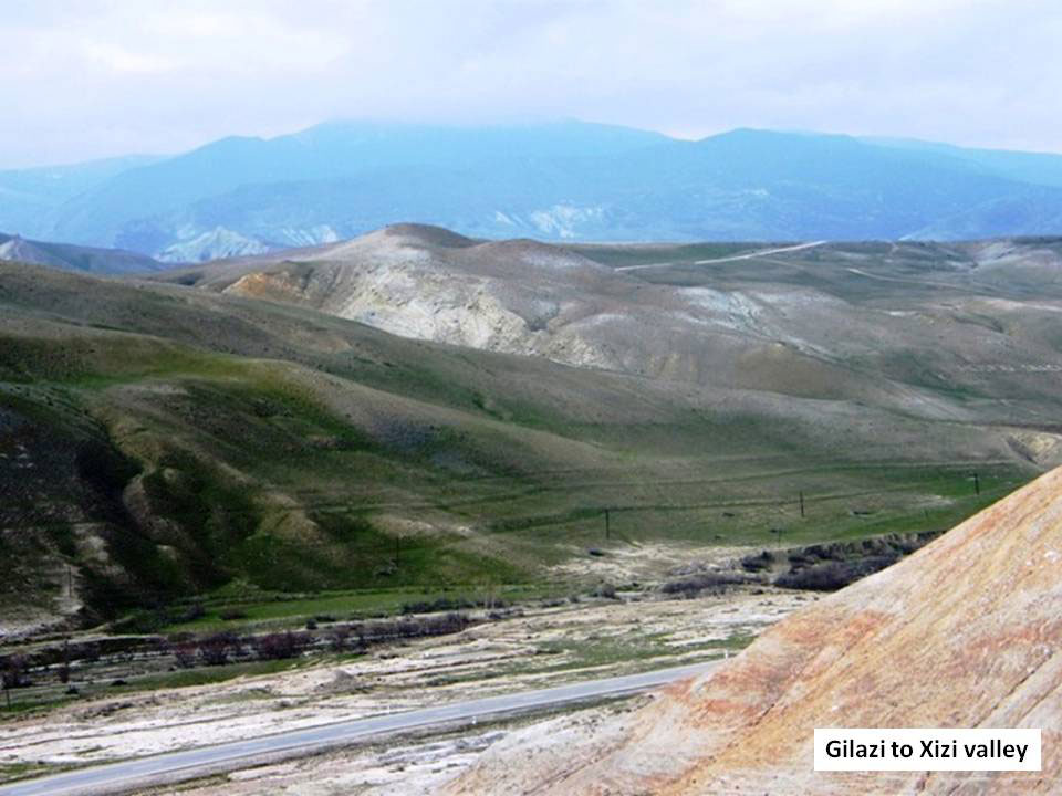
Figure 2. Parallel strandlines of Gilazi Valley. The upper strandline is at an elevation of ca 225m above average sea level and thought to be due to a combination river and glacial meltwater flooding. Strandlines are relatively young.
A possible explanation is that the land itself has risen due to tectonic uplift. However, radiocarbon dating of bulk shell fragments obtained from Gobustan terraces shows that this is not a correct assumption. (Gobustan Coordinates are 40° 6’33.95"N, 49°22’41.46"E). Shell fragments obtained at an elevation of 125m, 80-85m and 18-30m a.s.l., have measured ages of 16,770y, 14,310y and 28,500y respectively (by Beta lab). Logically, with tectonic uplift, older shells would naturally be located on a higher stratum above younger ones. This is not the case and demonstrates the dominance of transgression over uplift. In addition, the Caucasus are known to be rising at a rate of 1cm per year though this may not be true at the Caspian coastline where downward dipping stratigraphic layers near Besh Barmak and Gobustan indicate that subsidence into the Caspian basin may also be a factor.
However, absolute evidence of flooding is clearly demonstrated on a mudflow at the entrance to the Gilazi valley, where several strandlines ranging from 75 to 180m asl can be found. These are indicative of a massive short-lived deluge perhaps with falling sea level. (Figure C) (Gilazi mud flow coordinates: 40°50’50.43"N, 49°18’7.43"E).
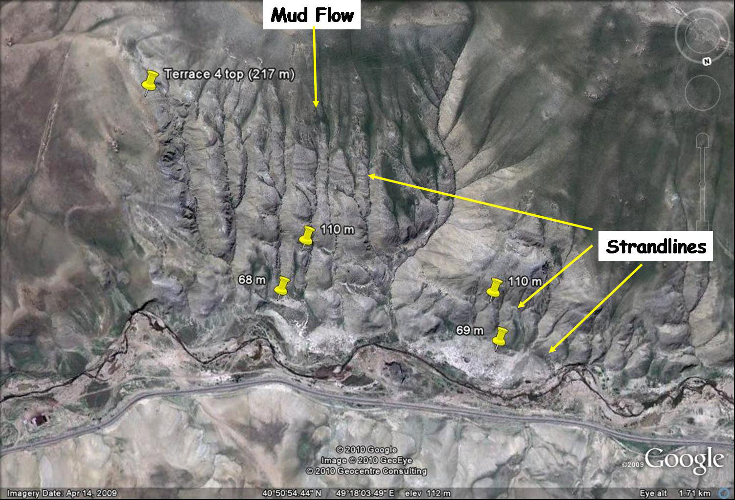
Figure C. Satellite image of Gilazi Valley entrance mudflow. Parallel strandlines cut across the soft strata and provide evidence of recent flooding/transgression.
Of interest here is the fact that correlations of terrace tops can also be made with spillover elevations. For example the extensive coastal plain seen to the north of Baku ranges from sea level at minus 28m to approximately +26m a.s.l. This upper elevation corresponds with the Manych spillover to the north of the Caucasus where the Caspian Sea would overflow to the Sea of Azov and Black Sea. If true, this indicates that there has been little change in elevation due to tectonics since the last spillover. As such it strongly indicates that the +26 m Manych spillway determines the upper level of the coastal terrace.
From this observation it was reasonable to consider a similar explanation for the stepped appearance of even higher terraces noted in the vicinity of Gilazi valley entrance. In this regard, the elevations of two other terrace tops were found to correlate with the Turgay spillover (+125m), which drained the large Siberian Glacial Lake Mansi, and the Kes Ket spillover at 167m which drained Glacial Lake Yenisei. The correlations may be a coincidence, but may indicate that higher Azerbaijani terraces are similarly defined by the elevation of the Siberian spillways and possibly associated with the inflowing of Russian rivers. In effect, the stepped terraces in the Azerbaijan landscape may be the result of an incremental river inflow cascading from Glacial Lakes Mansi and Yenisei, so resulting in a staircase like appearance.
Further evidence of prolonged river inflow during Ice Ages may be found near Gobustan in the form of thick varve like mud sediments at a sheltered escarpment. (Figure 3) These strandline-like features ranging from 60 to 80 m a.s.l. are in fact hardened dark brown coloured muddy sediment layers eroding from the hillside. (Escarpment Coordinates: 40° 3’49.47"N, 49°21’14.71"E). Radiocarbon dating of bulk shell fragments sampled at around 100m a.s.l. at the top of the escarpment provided a measured age to be 32460 +/- 480 years. (Beta Lab). This indicates a relatively young geological age and suggests the fine sediments may be due to Pleistocene inputs from diverted Siberian rivers.
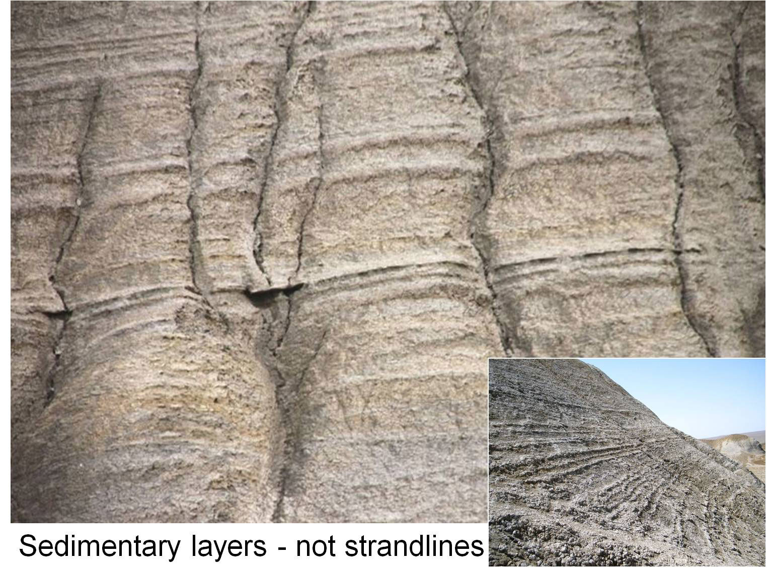
Figure 3. Apparent strandlines on sheltered face of a mud volcano near Gobustan. Their presence in erosion channels indicates sedimentary origins. Elevation is between 60 and 80m a.s.l.
It is interesting to note here that the bulk shell samples extracted from the escarpment are at a lower elevation (100m) and are older than those found on terraces at nearby Gobustan (125m). If the radiocarbon dating is accurate and coastal tectonics discounted, this further supports the interpretation of huge transgressions in the Caspian basin during the Pleistocene.
Interestingly, in an unpublished paper by Lioubimtseva, et al, provide evidence of a single giant freshwater lake covering most of the West Siberian Plain is deduced. She states:
‘Stretching some 1500 km from north to south, and a similar distance east to west at its widest points, at its maximum extent it would have had a surface area at least twice that of the Caspian Sea. Varying from several tens of metres to over 100 m in depth according to local topography, it would have contained of the order of hundreds of thousands of cubic km of water….this mega-lake appears from the available dates to have reached its maximum extent by around 24,000 years ago, and to have existed in some form up until around 12,000 or 13,000 radiocarbon years ago’ (Lioubimtseva et al).
If this is correct, then it suggests that the Turgay spillway at +126m a.s.l. draining the West Siberian Lake (i.e., Lake Mansi) was contiguous with the swollen Caspian Lake during the Ice Age and corresponds to both the extensive Sumgayit to Siyazan raised terrace and Gobustan radiocarbon dating around 17,000 years BP.
To summarize, it is therefore suspected that the swollen Caspian basin was deluged by a combination of diverted river water for millennia during the Ice Age when Arctic Ocean flowing rivers in Siberia were ice dammed, followed by a period of glacial meltwater as the Ice Age ended. In effect prolonged flooding due to river diversion created broad terraces, while at the end of the Ice Age beginning around 18ka BP glacial meltwater supplemented the water level to create even higher strandlines such as those seen ranging some 16km inland into the Gilazi Valley.
Glacial Dam Collapse in the Altai.
The diversion of rivers and glacial meltwater were not the only source of flooding into the Caspian basin. Other catastrophic floods happened with the collapse of glacial dams in the Altai region of Western Mongolia. The largest of these bodies of water involved the Chuya-Kuray lakes, which had a combined volume of 3500 km3. Such dams according to Professor Alexei Rudoy were unstable at the beginning and end of the Ice Ages. (Pers comment). As rivers became trapped by advancing glaciers at valley entrances, lakes built up only to reach a point of instability resulting in collapse of the ice dams. Glacial dams failed every 100 years or so, resulted in multiple floods and created characteristic features such as giant ripples, berms and scabland morphology (Rudoy). A similar sequence of glacial dam collapse has been extensively studied in the United States at Glacial Lake Missoula. Those from the Altai however are not so well known, but would have been equally devastating to those in the flood paths. The volume of water released with the largest of the Altai floods amounts to around 4% of the volume of the present Caspian Sea volume (79,000 km3), (Aladin. 1993), and would be sufficient to raise the Caspian Sea by a maximum of 9m given its current geography. Catastrophic though these glacial dam collapse floods may have been to coastal inhabitants, they were not responsible for the massive transgressions suggested by the Azeri terraces, nor had they the same significance.
As an aside, it may be speculated that even larger acute floods occurred when the onshore sea ice collapsed to release Lioubimtseva’s West Siberian Lake into the Arctic Ocean.
Putting the deluges into context, by extrapolating terrace and strandline elevations across the Caucasus and into the Black Sea region, it must have resulted in massive flooding across Eurasia to generate a super inland lake on a scale comparable in size, or larger, than the Mediterranean Sea. (Figure F). In this regard evidence of flooding and raised terraces can also be found in the Black Sea region where there are many examples of raised terracing also reaching a height of +250m a.s.l. (Ertek, 2011).
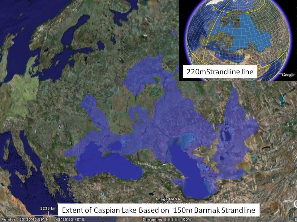
Figure F. Approximation of areal extent of swollen Caspian Lake based on strandlines above 150m and 220m a.s.l.
This inland sea or great flood would be a good candidate for the primeval seas of legend and myth. It may be possible that the collective memory of mankind passed on these events for thousands of years, until they were written in the ancient Aryan scriptures such as the Rigveda and Avesta only later to be adopted by the ancient Sumerians, from whom it maybe was recorded in the Bible. If so the earliest name for this great flood would be the Sea of Vorukashah. (Chapylega). This great flood however does not provide an explanation for the events of the Biblical flood. There may be another candidate for this.
Meltwater Paradox.
With so much fresh water coursing into the Aral and Caspian Seas (Kvalynian Lake) and Black Sea (Euxine Lake), i.e. the Ponto Caspian, a paradox becomes apparent. According to scientific literature, and given that the world’s longest ever river, the 8000km long meltwater cascade flowing from Siberia to the Mediterranean, it is odd that the river showed no obvious sign of discharging into the Aegean Sea during the period between 16,000 and 10,000 years BP. Instead, sediment core samples taken from the Aegean Seabed demonstrate that freshwater input only became significant between 10,000 and 6,000 years BP. (Aksu et al., 2002; Yanko-Hombach, 2007).( Figure 4)
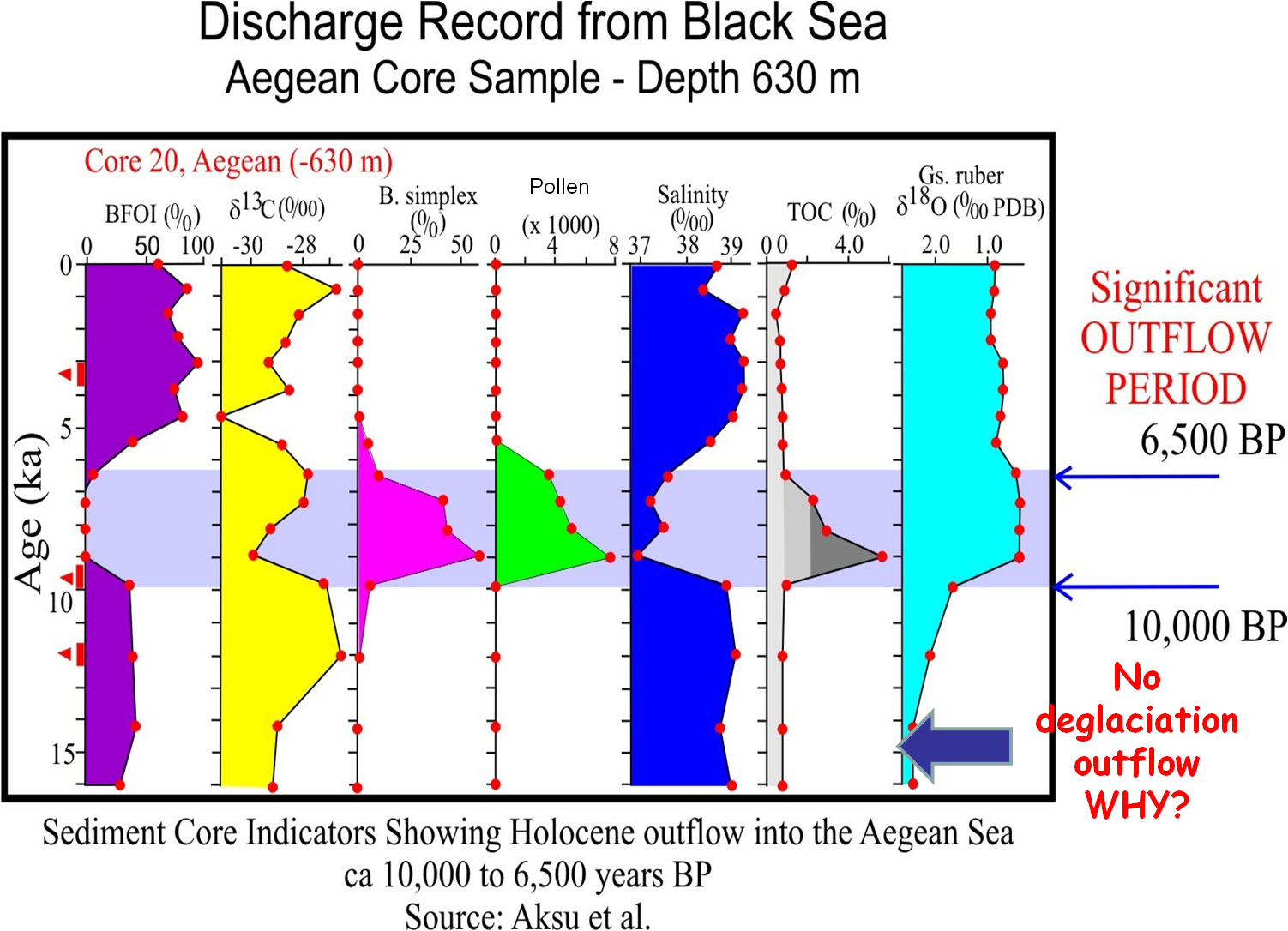
Figure 4. Core sample information from Aegean Sea dating back to 16,000 BP. Freshwater out flow only began at 10,000 BP when Bosporus opened. Prior to this a continental interior endorheic lake must have prevailed.
This can only mean that water was somehow trapped within a massive interior Eurasian lake—one that must have functioned in an endorheic manner. Indeed, the lack of discharge to the Aegean demonstrates massive flooding of the continental interior. This deduction supports the observations of raised terraces and strandlines in the Black and Caspian Seas. It also means that the Bosporus and Dardanelles were not yet opened to discharge excess meltwater as there would be indicators in the Aegean Seabed as meltwater flowed into it. With terrace and strandline elevations in excess of 120m, it is probable that the Black Sea exit to the Bosporus was as a closed bottleneck or choke point. In effect, it may be hypothesized that spillover from the swollen Black Sea basin is the reason for the Bosporus and Dardanelle channels opening around 10,000 years ago.
Allied to the observation of freshwater input into the Ponto Caspian another question arises concerning residual salinity. In view of the many ice ages during the 2.5 million years or so of the Pleistocene period, and the fresh water floods coursing through Caspian basin, it seems paradoxical that the Caspian Sea should have retained a salinity of around 120/00 (i.e. 1/3 oceanic water strength). Surely the Caspian basin saltwater, (and for that matter Azerbaijan’s salinated soils), would have winnowed or leached away long ago? How could this be? After all, it is recognized that the Black Sea suffered a similar Ice Age fate and was considered fresh water before 7500 years ago. Indeed, the Black Sea oscillated from a completely isolated interior lake to a marine environment more than eight times (Schrader, 1979; Zubakov, 1988). Logically then, (and even though the Ponto–Caspian may have functioned as a massive Eurasian endorheic basin, so retaining some saline waters), flushing and winnowing should have rendered the Caspian Sea a fresh water basin during the Pleistocene. While the Black Sea can refill from the Mediterranean Sea during interglacial oceanic highstands via the Bosporus, geography and topography dictates that the Caspian Sea cannot. If this assumption is correct then it begs the questions how did the Caspian Sea replenish its salt level?
A logical answer is that floodwater entered the continental interior from the Arctic Ocean. If this was the case then there would surely be evidence for this. In fact, a range of diverse evidence including relic Arctic and temperate water species, rock art, classical text and maps testifies that this might indeed be the case.(Figure D)
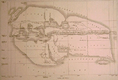
Figure D. Classical map from antiquity by Erastothenes 200 BC, – one of several maps that show the Caspian Sea connected to the Arctic Ocean.
Marine Species
The Ponto Caspian exhibits a number of relic Arctic species chief among which is the Caspian Seal Pusa caspica, which is a distant relation to the Arctic Ringed seal P. hispida. DNA studies indicate that P. caspica separated from its northern cousin by some 700,000 years and became established in the Caspian. This clearly demonstrates past connections.
Looking at another species, Ivanova reports the presence of the common or Blue Mussel Mytilus edulis in gravity cores at a depth of 100m in the North East of the Black Sea, dating between 6000 and 4400 year BP (Ivanova et al 2007). This is of significance because M. edulis is a temperate shallow water northern species found in the Atlantic and the Arctic Ocean/Barents Sea. It neither lives in the Caspian Sea nor the Mediterranean Sea, which excludes introduction from these locations. Its cousin Mytilus galloprovincialis—the Mediterranean mussel—only began to colonize the Black Sea from around 7500 BP once two way Bosporus flow was established (Major 2002).
Another species of interest is the Common Cockle Cardium edule (i.e. Cerastoderma edule) which is found in the Ponto Caspian basins. Scientists consider the animal was transported into the Black Sea as larvae once the global sea level reached the Bosporus sill at minus 40m a.s.l. around 7500 years BP. This however presents a provenance problem for again the common cockle is also not native to the Mediterranean Sea. While there is a possibility that the bivalve is misidentified (from its cousin C. glaucum) it does not explain how the Caspian and Aral Seas became populated. In addition, in order to reach the Caspian and Aral basins, the cockle had to migrate overland and uphill hundreds of kilometers, against the current, which is clearly unlikely, though birds and even anthropogenic influences (boats) may be involved as vectors. Of significance, too, is that C. edule (and its cohort the lagoon cockle C. glaucum) cannot survive in fresh or brackish water. Given that the Common Cockle is not native to the Mediterranean Sea an Arctic Ocean / Barents Sea influx may explain its presence.
Sea water chemistry.
Other research in the Black Sea supports the suggestion of an Arctic marine inflow at the beginning of the Holocene. For example, Major et al. observes the following:
Major concludes: ‘we also show that the inundation by the Mediterranean began at ~9.4 ka BP cal., earlier than previous indications of ~7.6 ka BP cal’ (Major et al., 2002). Major’s observations provide a controversial set of results that demonstrate brackish and marine conditions began to develop in the Black Sea, before the Mediterranean seemingly began to flow northwards through the Bosporus. (Major, 2006)
Holocene Outflow from the Black Sea.
The interpretation of an early onset Mediterranean inflow into the Black Sea basin contradicts the theory of a Holocene outflow from the Black Sea. Observations by Aksu et al, demonstrates a strong outflow to the Aegean Sea between 10,000 to 6,000 years BP. (Figure 4). During this time, fresh water outflow persisted for some 3500 years.
Strong outflow markers such as: the presence of pollen, increase in total organic carbon, a drop in seabed salinity, and presence of the dinoflagellate B.simplex – a marker of cool low water salinity, all provide positive evidence that the dominant flow was from north to south – Black Sea to the Mediterranean. Today there is no sign of similar terrestrial markers outflowing to the Aegean, so something clearly happened at around 10,000 years ago to drive out fresh water from the Black Sea. Furthermore, as it is only around 7600 years BP that Mediterranean species begin to appear in the Black Sea – once a two way flow becomes established through the Bosporus, this raises the question of the cause of salination beginning some 3000 years earlier.
It is also interesting to note from Aksu’s Aegean core samples that there was no outflowing of fresh water from the Black Sea during deglaciation from around 16,000 years BP up to the beginning of the Holocene period 10,000 years ago. This indicates that the Bosporus was not yet open and that glacial meltwater water was being retained within the Eurasian interior in the late Pleistocene, thus providing corroborative evidence for the elevated Azerbaijan strandlines and massive flooding.
Aksu’s Holocene outflow theory presents yet another puzzle to do with the paleoclimate and the source of water creating the outflow. Flooding begin towards the end of the Younger Dryas Ice Age period, when glaciers were still reforming and the climate was cold and dry. With reduced rainfall and minimal glacial meltwater inflow to the Black Sea, the question of where such vast amounts of water could have come from to fill the Black Sea basin to its overflow point, becomes very pertinent. For this to have happened the theory requires a rapid Black Sea refill from a low level standpoint below 100m to an outflow elevation of the Bosporus sill at around minus 40m (Aksu et al 2002). This again is of interest for in order to raise the Black Sea/Lake by some 60 meters, the amount of water required would be around (284,000 km3), – i.e. the equivalent of about 800 years of rainfall, assuming double today’s rainfall level. (Note. Currently, North European river input is largely responsible for a net outflow from the Black Sea of around 300 km3/yrAs such rainfall alone could not provide sufficient water to create the outflow.
In consequence, the Holocene outflow theory demonstrates a dominant fresh water outflow but seems to be unable to account for the large volumes of freshwater exiting the Black Sea Basin. Equally at this early time marine conditions begin to become established in the Black Sea but with species that are not found in the Mediterranean. This suggests that the Mediterranean cannot be the source of the marine influx and so points in the direction of an influx of Arctic Sea water.
Assuming that this happened, then denser sea water would enter the Ponto Caspian and displace fresh water towards the Mediterranean. The net effects would be: a protracted outflow of Black Sea fresh water; the commencement of salination; and an influx and colonization of some arctic species. Terrestrial fresh water outflowing and associated biomarkers would also cease once as the outflow weakened and two way flow normalized in the Bosporus, ( – a feature that persists today).
A late Pleistocene / Early Holocene Arctic marine influx seems to provide answers to the question of the Holocene outflow, but this then raises the question of how arctic waters could enter the continental interior.
Marine Flood
In answering the question of a possible Arctic Ocean inflow, the very different late Ice Age environmental conditions need to be considered. With the weight of two to three kilometres of ice pressing down on the land, the Earth’s crust was depressed downwards. As such this would have allowed sea water to travel much further inland. With the ice sheets stretching south of Moscow it seems plausible that the northern landmass was depressed such that a route was opened through to the Caspian and Black Seas. For this to happen, the Earth’s crust would have to be depressed by around 100-150m. Even today isostatic rebound is continuing to slowly raise Scotland and Northern Europe so it seems not unreasonable that the land was depressed enough for sea to enter the continental interior.
Another consideration is that that tides are especially high in northern latitudes: for example spring tides at the Bay of Fundy can reach 16m. This tidal phenomenon exists because the bay has a few distinct features: a substantial amount of water, a unique funnel shape and immense depth that causes resonance where its natural period of oscillation is between 12 and 13 hours. Indeed, each day, the tides move more than 100 km3 in and out of the bay, a volume four times greater than the discharge of the world’s rivers combined. Sediments at the mouth of the Bay of Fundy are also characterized by huge sand waves. (Gulf of Maine Census, 2012). Interestingly to the south of the Barents Sea, the tides at Mezen Bay are up to 10 metres and sand waves are also present offshore with wave heights up to 17m. Like the Bay of Fundy these are hydrogenic sculptural relief forms of tidal origin. (Pavlidid, Ionin, Scherbakov, et al., 1998).
It may be speculated then that due to a combination of lower Ice Age topography and oceanographic conditions, (perhaps with tidal action and the North Atlantic Conveyor funnelling water into the newly exposed and the isostatically depressed landscape), conditions may have been created that favoured spring tides ‘pumping’ large volumes of seawater into the headwaters of the Volga and Don. Such a scenario, perhaps lasting a few thousand years as the ice sheets disintegrated would is worth considering. Other than a cosmic collision and super tsunami, the ice sheet isokinetic depression and large tides may provide answers the earlier questions and an explanation as to why the Caspian Sea is salty.
Classical References indicating an Arctic Inflow
.
Curiously, there are also references in classical texts that allude to Russian rivers swelling and flowing into the Black Sea. One even involves seals becoming more common in the Caspian:
From the history of Berossus, quoted by Syncellus and Eusebius, it is clear that seals began to appear in greater numbers (in the Caspian) as the deluge drew near, which is significant as indicating an inflow from the Arctic into the Asiatic Mediterranean (Fessenden, 1933).
It is worth noting too that there are a number of ancient maps such as Eratosthenes and Strabo, indicating the Caspian Sea was connected to the Arctic Ocean in antiquity. Indeed, Strabo also mentions that some persons still believed in a connection of the Caspian with the lake Maiotis (Sea of Azov), thus indicating a much later connection between the two basins. (Flinders Petrie, 1924).
Diodorus Sicula further provides an account of the Black Sea bursting through into the Bosporus. (1BC – Bibliotheca Historica):
The Samothracians have a story that before the floods which befell other people, a great one took place among them, in the course of which the outlet at the Cyanean Rocks was first rent asunder and then the Hellespont’. Note. The Cyanean Rocks were two islets which in Diodorus’ time stood at the Bosporus strait where this joins the Black Sea. (Strabo).
Diodorus was clearly referring to the Samothracians, remembering that the former Bosporus land bridge had been ‘rent asunder’ by a bursting through of water. He then says:
For the Pontus (Black Sea) which had at that time the form of a lake, was so swollen by the rivers that flow into it, that, because of the great flood which had poured into it, the waters burst forth violently into the Hellespont.
In all of the writings that survive from antiquity only Diodorus mentions the Black Sea was once a lake before 5600 BC. While Diodorus gives no explanation for the large volumes of water filling the northern rivers, and as this cannot be explained by glacial meltwater or rainfall, then however improbable it may be, consideration should be given to an inflow of Arctic waters.
Rock Art Evidence of a Marine Inflow.
Looking at the marine influx question from yet another perspective and acknowledging that the Caspian Sea once overflowed to the Sea of Azov/Black Sea, it becomes possible to reinterpret some intriguing rock art at Gobustan archaeological reserve. Two examples are relevant.
On Kichickdash hill a 4m long ‘fish’ carved on this outcrop bears no anatomical relationship to any Caspian Sea species. The large size of the carving and its anatomical features suggests it may in fact be a dolphin or beaked whale as viewed from above. (Farajova, 2009) (Figure A).
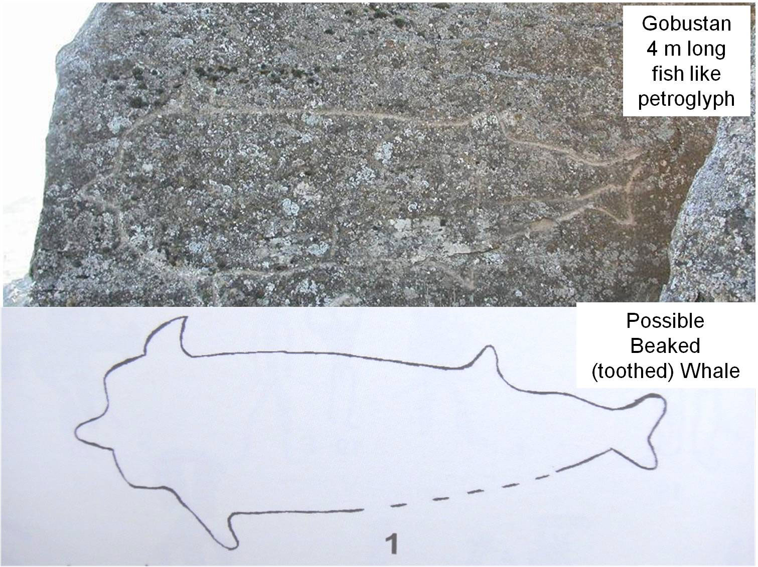
Figure A. A large fish like petroglyph which bears more of a resemblance to a toothed whale. Large cetaceans can only be present if the Caspian Sea was connected to the Arctic Ocean.
A second carving is remarkably like a diving bird. The carving shown in Figure B has two fin-like forelimbs, two flipper like rear limbs and a tail. If it is accepted that the ancient rock artists were accurate in their observations, the closest similarity to any animal is actually to a bird—possibly a member of the Auk family, the Guillemot. Coincidentally the most common Auk in Arctic waters is Brunnich’s Guillemot and a characteristic feature of this bird is a distinct white stripe on its beak, – the gape stripe. It is interesting to note that the rock art also appears to show a line or stripe on the beak and suggests the Stone Age artist has done a remarkable job in portraying this species.

Figure B. Comparison of dolphin like petroglyph to the Arctic Brunnich’e Guillemot. Note feathered tail like appearance and characteristic ‘gape’ stripe on bill.
If both interpretations are correct, (whale and auk) then it suggests that cetaceans and seabirds penetrated far into the continental interior. If so, perhaps the ancient cartographers were correct in their ancient maps showing a Caspian Sea channel open to the Arctic.
Sun Boat and Zig Zag lines. (Boyukdash Boulder No. 29)
Perhaps the most famous carved panel at Gobustan is that of the Hunter Scene and a multi-oared ‘sun boat’. Here, it is interesting to observe that the wavy or zigzag lines behind the hunter are interpreted as water. Azeri archaeologists consider the zigzags to represent rainfall. However knowing that the Caspian Sea overflowing into the Manych corridor at +26m a.s.l, it becomes possible to consider that the long thin set of zigzag lines running behind the hunter, with an off take to the top left, may in fact, be a representation of a swollen the Caspian Sea. (Figure 5) The Caspian Sea similarly is elongated and had an outflow to the North West. In effect, this carving may provide an eye-witness account of the Caspian Sea spilling through the Manych corridor into the Sea of Azov. If so, it supports Strabo’s comments, but also suggests the Caspian Sea was elevated at least in the Early Neolithic when the boat carvings were created. Given that there are many multi-oared boats carved at Gobustan, it further suggests that Early Man had the knowledge and capability to navigate great distances potentially from Central Asia to the Mediterranean.

Figure 5. Zig zag lines behing hunter are recognized as meaning water. Archaeologists consider it to be rain. However the juxtaposition near to the Sun Boat and the elongated shape plus the off take to the top left suggests this may be a representation of the Caspian Sea at an elevation in excess of 26m a.s.l.
As mentioned above, evidence of possible navigation and cultural connections may be implied from the presence of ‘cart ruts’ on the Apsheron Peninsula. While it is not known exactly what these man made carvings were used for, they are very similar to the more extensive ‘cart ruts’ found around the Mediterranean. The latter, particularly those in Malta date, from around 7000 to 4000 years BP and are the product of a maritime culture (Gallagher, 2002; Mottershead, 2008). With an elevated sea level, East to West navigation, was a distinct possibility.
In this regard and of possible significance are numerous rock art carvings of multi-oared boats in Egypt’s Wadis Hamamat and Barramyia (Wilkinson, 2003). These carvings have strong similarities to those found at Gobustan. This could be archaeologically important, for the famous Egyptologist Sir William Mathew Flinders Petrie was convinced (based on philological and some archaeological evidence) of ancestral connections between pre-dynastic Egyptians and the Caucasus. He was, however, unable to explain how this could have come about, and left the challenge open to future generations.
In this context it is noteworthy that pottery from the pre-dynastic Badarian period similarly shows twin pennanted multi-oared boats passing by a long line of mountains which is interpreted by Margaret Murray as descriptive of the landscape passed on the journey made by Egyptian incomers (Murray, 1949). (Figure E) This frames the question, – could the migrants be navigating along the Caucasus Mountain range? It is also significant that the upraised arm gesture is a relatively common symbol in Azerbaijan’s rock art, and even appears in an as yet unstudied huge 200m geoglyph. (Gallagher, 2011).
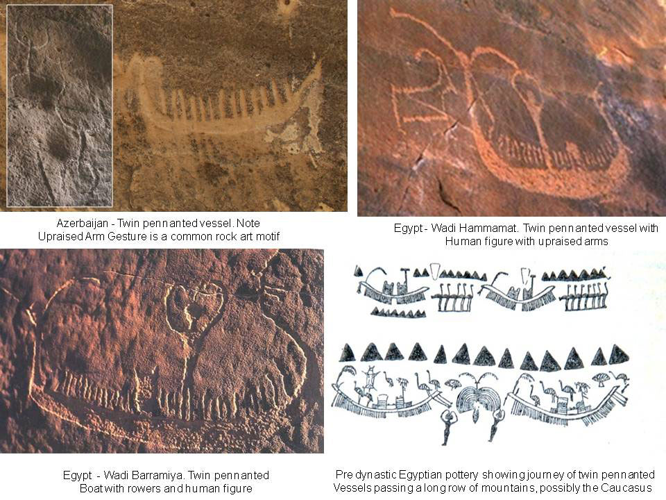
Figure E. Rock art boat with multiple oarsmen, a twin pennant and human figure with upraised arms show similarities between Azerbaijan and Egypt.
In the context of a massive inland body of water and the probability of navigation over huge distances, the central nature of the Caucasian isthmus begins to assume greater significance than it does today. For example the Caucasus becomes an obvious place for mariners to settle. In this regard, one of the perplexing problems confronting linguists is the large and extremely varied array of languages spoken in and around the Caucasus Mountains. Indeed, linguistic comparison allows these languages to be classified into several language families with little or no discernible affinity to each other. (Wikipedia). While it is currently difficult to comprehend how this situation could have arisen, the puzzle perhaps begins to resolve itself if ancient navigation in a deluged landscape is taken into consideration. Linguists may wish to consider this possibility. Indeed a subsequent diaspora from the Caucasus region by boat might also offer a line of investigation for flood stories in more distant lands, cultures and languages.
Conclusion
For several years now, efforts to try to understand the archaeological and geomorphological puzzles in the Azerbaijani landscape have been perplexing and frustrating and remain an engrossing challenge. The raised terraces and strandlines are obviously very real and call for scientific explanation. Trying to make sense of them has been a stretch of the imagination, involved exploring several scientific disciplines and looking for clues far outside the Caspian region and deep into the Ice Ages. While there may be other interpretations for the flood events and the biological and archaeological phenomena observed, the complex picture emerging involving river and glacial meltwater flooding, plus a period of Arctic water inflow, (however improbable), seems to provide explanations for the varied observations and findings. There is an internal consistency in the observations that point towards different types of flooding. The theories and interpretations may well be incorrect, but are of interest and are amenable to investigation.
Today, science and technology have many powerful investigative tools, and it is hoped that this account will serve to encourage investigation. Soil chemistry and the search for microfossils could provide early confirmation of an Arctic inflow. If any of the above ideas were confirmed, especially the sequence and timing of the floods, the extent of a massive Eurasian lake sea, and the reality of an Arctic marine incursion, then it would be of far-reaching significance to many branches of science. The consequences of a Eurasian lake would surely have affected paleoclimate, regional biogeography and human demographics. Indeed, if confirmed, the possible early Holocene marine flood may even provide an explanation for Biblical and legendary flood stories.
Scientists and academics at the Azerbaijan National Academy of Science are in a fortunate position to investigate the geomorphology of mud volcanoes and landscape to confirm flood types, sequences, heights and timelines. Determining these could provide an invaluable insight into a very different landscape: one where internal navigation may have been possible for millennia in prehistory. Such a scenario, must surely have influenced ancient human life and helped shape prehistory. This is surely worth investigating.
References
- Aksu, Ali E. et al. 2002. Persistent Holocene Outflow from the Black Sea to the Eastern Mediterranean Contradicts Noah’s Flood Hypothesis. GSA Today, May 2002, 12(5): 4–10.
- Aladin, N. V., Plotnikov I. S. (1993), Large saline lakes of former USSR: a summary review: Hydrobiologia 267: 1-12, .
- Baker. V.R. (2007) ‘Greatest Floods and Largest Rivers’. Large Rivers: Geomorphology and Management. John Wiley and Sons. Editor. A.Gupta. 65-74. Chapylega, A
- Deuser, W.G., 1972. Late-Pleistocene and Holocene history of the Black Sea as indicated by stable-isotope studies. Journal of Geophysical Research, 77(6): 1071-1077.
- Ertek,T.A., Yildirim,C. Aytaç,A., Kutoglu,S., Kurban,. K, Erginal,.E. Correlation of the marine terraces at the Turkish coast and their interpretation’. Proceedings of MEDCOAST 03 International Conference.(2011)
- Farajova. M. (2009). ‘Rock art of Azerbaijan’. Aspoligraph. P.192.
- Fessenden, R.A. The Deluged Civilisation of the Caucasus Isthmus (1933) http://www.radiocom.net/Deluge/Deluge7-10.htm.
- Gallagher, R (2002). Cart Ruts and Stone Circles’. Azerbaijan International. http://azer.com/aiweb/categories/magazine/ai103_folder/103_articles/103_cart_ruts.html
- Gallagher, R.. Anthropomorphic Images in Azerbaijan’s Landscape. Visions of Azerbaijan. July/August 2011. http://www.visions.az/history,307/
- Grosswald, M. G. (1988). An Antarctic-style ice sheet in the northern hemisphere: Toward a new global glacial theory. Polar Geography, Vol12,Issue 4, p. 239-267
- Grosswald, M.G., (1998). ‘New Approach to the Ice Age Paleohydrology of Northern Eurasia’. ‘Paleohydrological and Environmental Change’. Editors Benito.G and Baker., V.R. 199-214.
- Gulf of Maine Census. http://www.gulfofmaine-census.org/about-the-gulf/physical-characteristics/physioregions/bay-of-fundy/. 2012.
- Ivanova, E.V., Murdmaa, I.O., Chepalyga,A.L., Cronin, T.M. Pasechnik, I.V. Levchenko, O.V , Howe, S.S., Manushkina, A.V d, Elena A. Platonova, E.A. Holocene sea-level oscillations and environmental changes on the Eastern Black Sea shelf. Palaeogeography, Palaeoclimatology, Palaeoecology 246 (2007) 228–259.
- Lioubimtseva, E.U., Gorshkov S.P. , Adams J.M., A Gianr Siberian Lake During the Last Glacial: Evidence and Implications. Unpublished paper. http://www.esd.ornl.gov/projects/qen/lake.html.
- Major, C.O, Goldstein, S.L., Ryan, W.B.F., Lericolais, G., Piotrowski, A.M., Hajdas, I., The co-evolution of Black Sea level and composition through the lastdeglaciation and its paleoclimatic significance. Quaternary Science Reviews 25 (2006) 2031–2047.
- Mangerud. J., Astakhov. V., Jakobsson. M, Svendsen. J.I. (2001) ‘Rapid Communication – Huge Ice Age Lakes in Russia’. Journal of Quaternary Science 16(8) 773-777.
- Mangerud. M.J. et al. (2004) ‘Ice Dammed Lakes and Rerouting of the Draining of northern Eurasia During the Last Glaciation’. Quaternary Science Review 23 1313-1332.
- Mamedov, AV, (1997), The late Pleistocene–Holocene history of the Caspian Sea:
Quaternary International, v. 41–42, 161–166. - Mottershead, D., Pearson, A. & Schaefer, M. (2008). The cart-ruts of Malta: an applied geomorphology approach. Antiquity, 82(318), 1065–1079.
- Murray, M. (1949). The Splendour That Was Egypt. Sidgwick & Jackson Ltd ed (1964)
- Pavlidid, Yu.G., Ionin,A.S.., Scherbakov, F.A., et al (1998) Arctic Shelf. Late Quaternary history as a basement for future forecast scenario. Moscow: GEOS, p.187 (in Russian). (Ref Seabed Morphology of the Russian Arctic Shelf by Sergey Nikiforov, editor. Nova Science Publishers.(2010)
- Petrie, Sir William Flinders. (1924) ‘The Caucasian Atlantis and Egypt’. (Ancient Egypt, December)
- Petrie, Sir William Flinders. (1926) ‘The Origins of the Book of the Dead.’ (Ancient Egypt, June).
- Rudoy. A., (1998) ‘Mountain Ice Dammed Lakes of Southern Siberia and their Influence on the Development and Regime of the Intercontinental Runoff Systems of North Asia in the Late Pleistocene. ‘Paleohydrological and Environmental Change’. Editors Benito.G and Baker., V.R. John Wiley and Sons. 215-234.
- Schrader, H., J., 1979. Quaternary paleoclimatology of the Black Sea basin. Sedimentary Geology, 23(1 4): 165 -180
- Strabo,. Geography Book II Chapter 1
- Wikipedia. ‘Gobustan Rock Art Cultural Landscape’. http://en.wikipedia.org/wiki/Gobustan_Rock_Art_Cultural_Landscape.
- Wikipedia. ‘Languages of the Caucasus’, http://en.wikipedia.org/wiki/Languages_of_the_Caucasus
- Yanko-Hombach , Valentina. 2007. The Black Sea Flood Question: Changes in Coastline, Climate and Human Settlement. Springer ISBN 1-4020-4774-6.
- Wilkinson, T, (2003), Genesis of the Pharaohs, Thames and Hudson.
- Zubakov, V.A., 1988. Climatostratigraphic scheme of the Black Sea Pleistocene and its correlation with the oxygen isotope scale and glacial events. Quaternary Research, 29(1):1 -24.