


On the necessity of researching and protecting these testimonies of the past. The following lines are a brief description of the subject. Further information can be found on my website www.cartruts.de and in my book Wege ins Nichts, which translates as Paths to Nowhere.
Introduction
Parallel grooves, which at first glance resemble petrified vehicle tracks, are found on all continents with the exception of Australia and Antarctica. They are found in various types of rock and often exhibit the same characteristics.
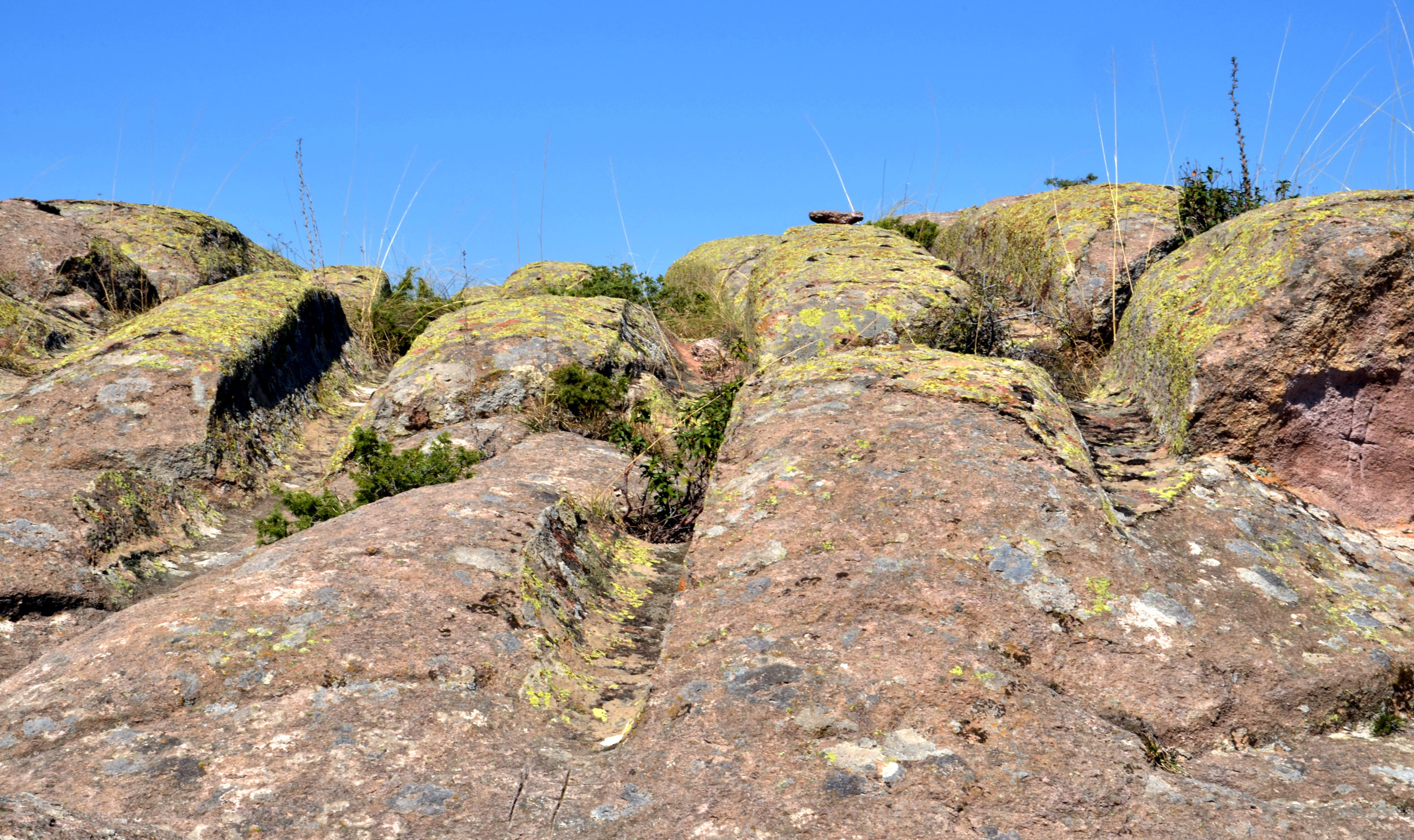
Image 1: Tracks near Kayıhan in Western Anatolia in Turkey
Photo by Uwe Schneider
These are certainly not natural geological phenomena but rather deliberately artificial relics, whose origin and creators are completely unknown.
Various terms have been used to describe these mysterious grooves, including rock tracks, drag marks, track grooves and cart tracks. However, in recent years, the term Cart-Ruts, which is associated with large areas of such grooves on the Maltese islands, has become established.
“These tracks will be the routes of archaeologists for a long time to come.” (José Sabater, 1877)
The characteristics of these tracks and the frequently bizarre peculiarities found in their surroundings stubbornly resist rational explanation by archaeology.
Depending on the region and country, there are different and sometimes contradictory attempts at explanation.
Of course, I am aware of the controversial nature of this topic. How can it be that 55 years after the first manned moon landing, our planet still holds an archaeological riddle to which there are still no satisfactory answers!
In my opinion, there are three reasons for this. Firstly, the tracks appear quite modest and inconspicuous. Indeed, they are often heavily eroded and barely visible. They are certainly far less noticeable than other spectacular constructions from our past, such as the pyramids.
Secondly, one’s first thought is that these tracks must have been made by vehicles. What else could it have been? The fact that no traces of draught animals are visible is not conspicuous.
Thirdly, anyone confronted with the existence of seemingly petrified vehicle tracks will probably believe it’s an April Fool’s joke. Only on closer inspection does it become clear that the tracks are a very bizarre mystery from our past.
Incidences
Based on the current state of knowledge, Cart-Ruts can be found on Easter Island (Chile), in Brazil, Mexico, the USA, the Azores, Portugal, Scotland, France, Spain, including Majorca and Menorca, Libya and South Africa, Italy, including Sardinia and Sicily, but also in Germany, Austria, Switzerland, Croatia, and Cyprus. Huge occurrences have been discovered in Western Anatolia and Cappadocia, but they are also found in Crimea, Azerbaijan, India, China, and Japan. And, of course, there are the tracks on Malta and the neighbouring island of Gozo, which are probably the best known and were the first to reveal the mystery.
For 10 years now, I have been collecting information on this topic, and it is surprising to see that previously unknown areas with Cart-Ruts are still being discovered, largely through internet research but also through accidental discoveries during my excursions.
Characteristics
Cart-Ruts consist of parallel grooves in various types of rock, giving the impression of tracks made by unknown vehicles. Archaeology generally assumes that they are the tracks of animal-drawn carts. Based on current knowledge, the tracks are found in limestone, volcanic tuff deposits, sandstone, and granite.
The tracks come in two different forms. The first type has V-shaped cuts with narrow tracks only a few centimetres wide and either flat or rounded bases (Image 2). The second type has a significantly wider and flatter track base, with almost vertical side walls. This type is more common in southern regions, while the first type can be found, for example, in the Alpine region. Both types are found in large numbers on Malta, whereas in Western Anatolia and Cappadocia, only the tracks with the wider base are present (see Image 1).
Only in Western Anatolia have I been able to document a very short fragment of a track with a narrower, rounded track base.

Image 2: V-shaped tracks in the limestone at the site of Su Crucisissu Mannu on the Italian island of Sardinia.
Photo by Uwe Schneider
Another very remarkable detail of some tracks is that rock obstacles have been broken through. There are some cuts up to about 3 meters deep in the rock, at the bottom of which the Cart-Ruts run. The reason for this is difficult to comprehend, as it would have been possible to avoid the rock barrier or continue the path on other parts of the rock surface. It is not uncommon to find clear scratch-and-drag marks on the side walls of these cuts (Image 3).
Documented in Germany, Italy, France, Spain, Austria, Switzerland, the USA, Western Anatolia, Cappadocia, and Japan.
The track in Spain, for example, is located on the limestone plateau of Castellar de Meca and runs for about 200 meters at a depth of two to three meters through the limestone. The question arises as to how these cuts were made in limestone, sandstone, and volcanic tuff, given the absence of cutting marks. In Western Anatolia, I documented several tracks where the left and right track bases are at different heights due to terrain, yet the track bases remain horizontal. How could this have worked technically for a vehicle? The same characteristic can also be seen in a track on the Maltese island of Gozo (Image 4).
In Sigean near Narbonne in France, there is a wonderfully preserved track with a curious detail: looking northwest, the left track disappears for about 3 meters, as if the vehicle continued only on the right side. Except for a small indentation about 20 cm long, only the smooth, polished surface of the limestone is visible, with no trace of a track, though the surface seems slightly worn.
Another oddity is the occasional change in track width.
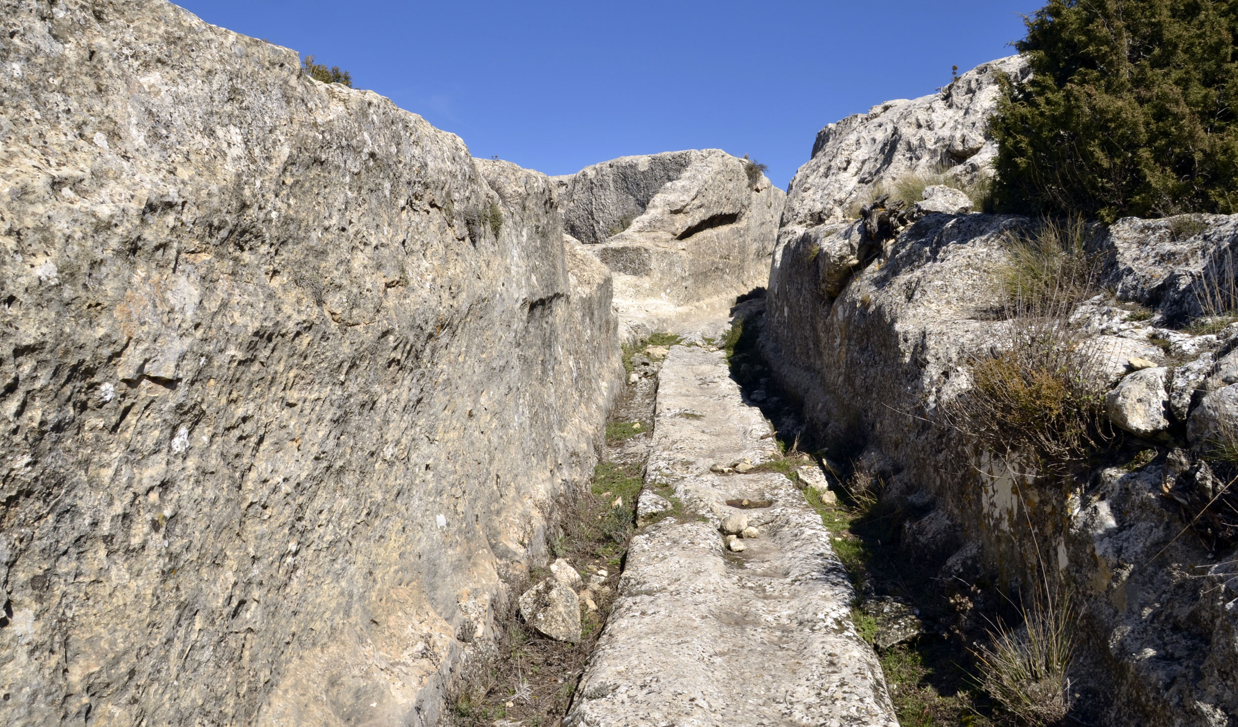
Image 3: Ascent at Castellar de Meca in Spain
Photo by Uwe Schneider
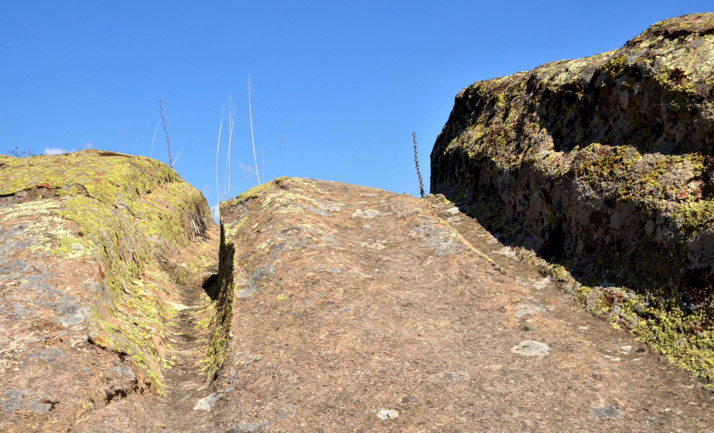
Image 4: Different heights near Kayhan in Turkey
Photo by Uwe Schneider
Further peculiarities in the surroundings of the tracks
It is not uncommon to find modifications to the rock in the middle of the Cart-Ruts and/or in their immediate surroundings. The purpose of this remains unknown. I have documented many Cart-Ruts where a broad abrasion can be found in the middle, reminiscent of drag marks, for example, in Malta, France, Spain, Italy, Azerbaijan, and Turkey (Images 5 and 6).
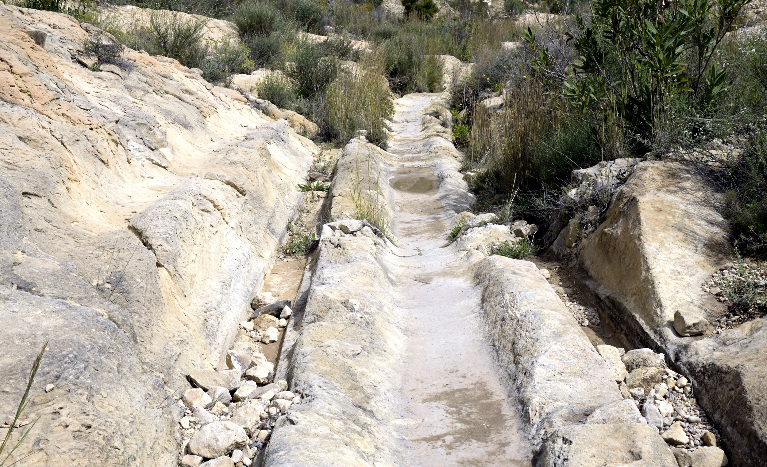
Image 5: Drag marks near Bonavista in Spain
Photo by Uwe Schneider
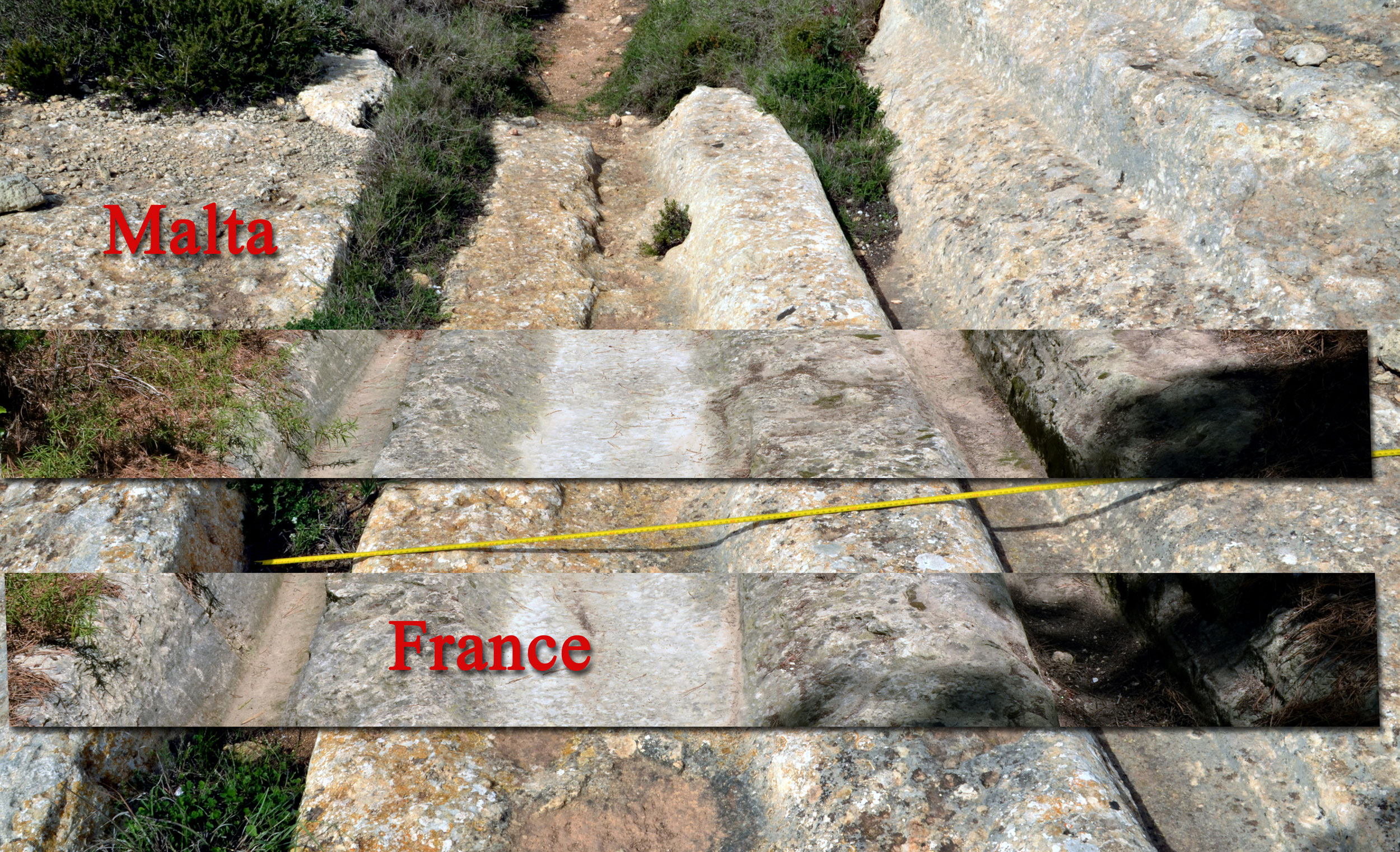
Image 6: Drag marks in Malta and France
Photo by Uwe Schneider
The tracks shown in Image 6 are identical, down to the centimeter! Another peculiarity is stamp-like depressions inside and outside the tracks, found in Sicily, Malta, the USA, and Cappadocia in Turkey. In Western Anatolia, there are many Cart-Ruts with scratch marks visible inside the tracks, as well as on the left and right when passing through rock obstacles (Images 7 and 8).
Rarer still are inexplicable single tracks, which I first saw in Phrygia in Western Anatolia. By now, I have also seen these tracks in Spain and Sardinia. I think one can rule out the possibility that these were water channels, as the height profile does not allow for water transport.
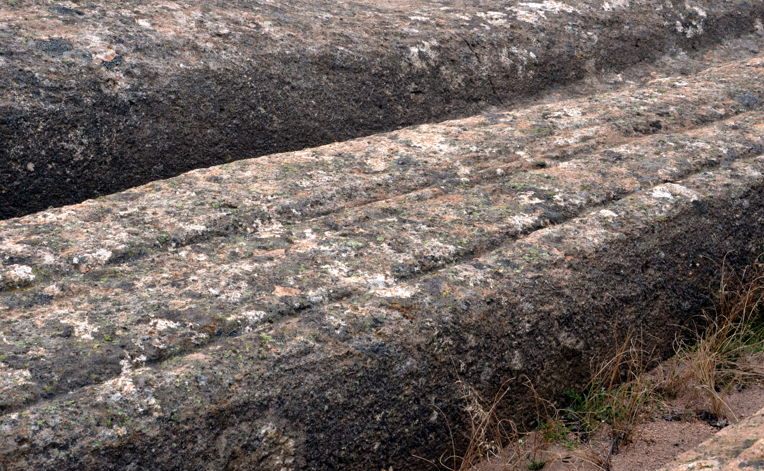
Image 7: Scratch marks in Phrygia, Western Anatolia in Turkey
Photo by Uwe Schneider
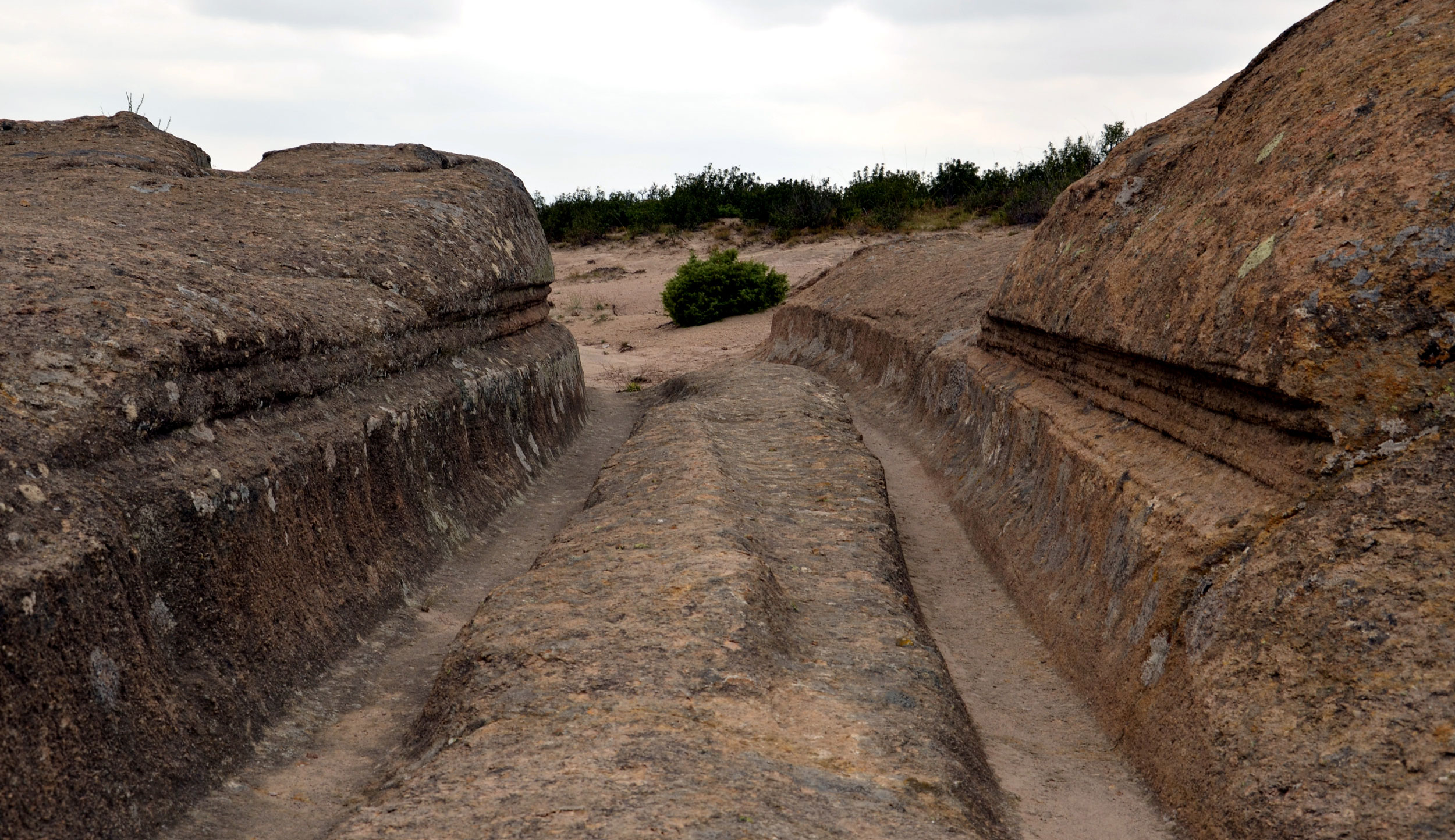
Image 8: Scratch marks in Phrygia, Western Anatolia in Turkey
Photo by Uwe Schneider
Also, very rarely, within these single tracks, one finds step-like structures. They can be found in Spain, Sardinia, and Cappadocia (Image 9).
Not infrequently, one can find perpendicular notches to the track that resemble, to some extent, the remnants of tracks made by tracked vehicles. These have been documented in the USA, Spain, Italy (Sicily and Sardinia), Malta, Western Anatolia, Cappadocia, Crimea, and China (Image 10).
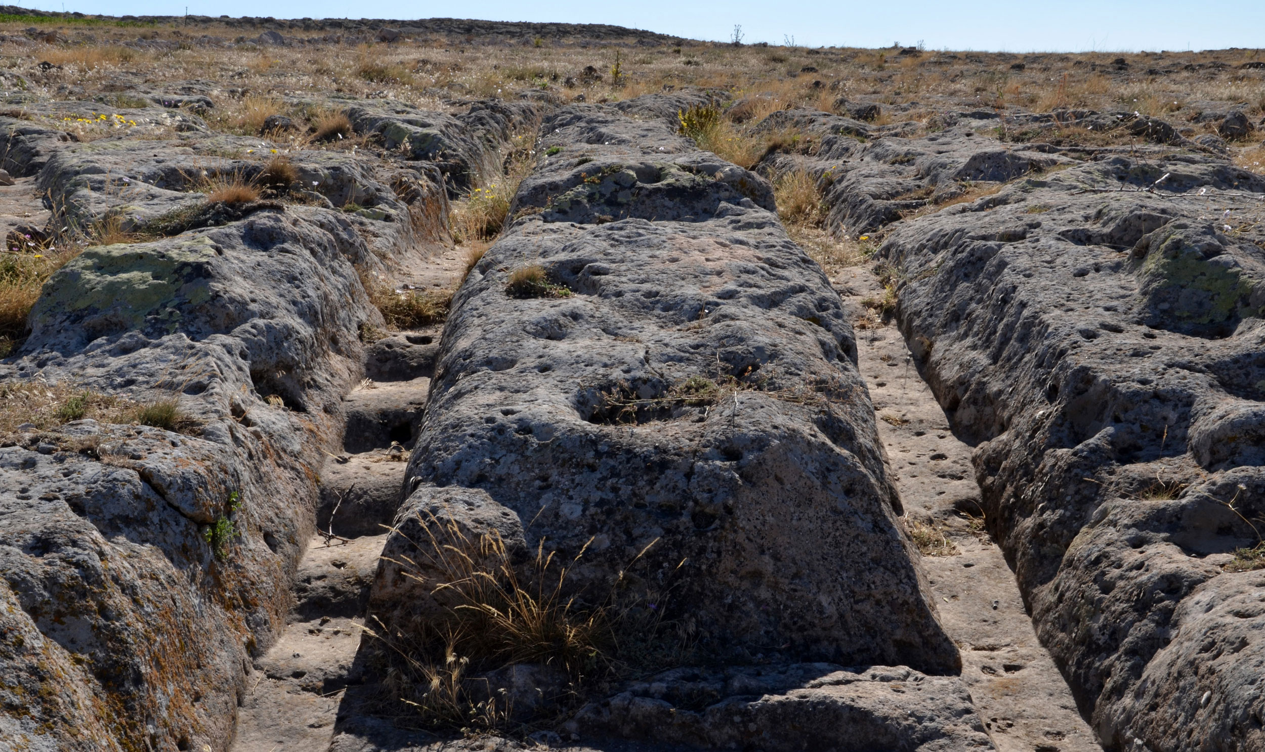
Image 9: Steps in Cappadocia in Turkey
Photo by Uwe Schneider
Image 10: Tracks resembling those of tracked vehicles in Sicily
Photo by Uwe Schneider
Additionally, terrace-like modifications to the rock can be found here and there just outside the Cart-Ruts, giving the impression that there were different construction phases. This can be seen in the USA, Germany, France, and Spain.
In Spain and Cappadocia, Cart-Ruts can be observed that, due to the enormous differences in erosion, must have come from significantly different periods. Obviously, older tracks are radically cut off by younger tracks (Image 11).
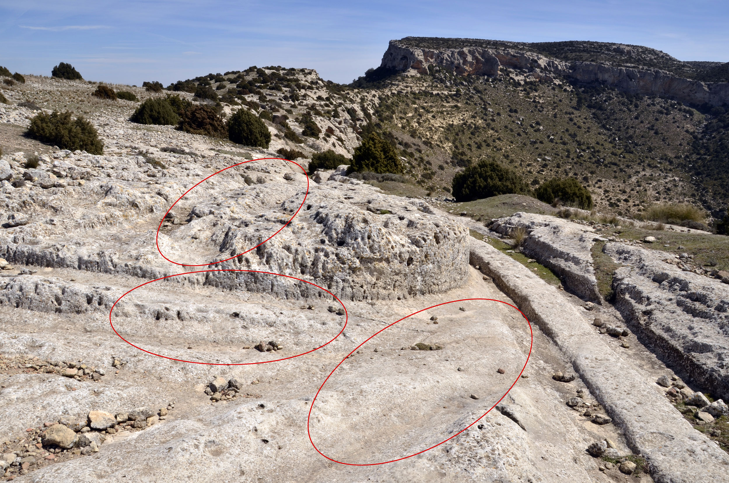
Image 11: Tracks from different times on the Castellar de Meca in Spain.
Photo by Uwe Schneider
First Thoughts on Characteristics
The question that arises for me is what processes led to the formation of these tracks in various types of stone. After examining hundreds of Cart-Ruts, I have yet to find a single one that appears to have been deliberately carved into the rock using tools. Setting aside those affected by erosion, the tracks run smoothly and elegantly through the rock.
It seems highly unlikely that these deep grooves were created by repeated cart usage along the exact same route, with precision to the centimetre. Swiss researchers conducted an abrasion experiment that found that, with a weight of 100 kilograms and after 10,000 passes, the stone only showed an abrasion depth of 1–2 millimetres. Currently, there is no logical or conclusive explanation (see Images 12 and 13).
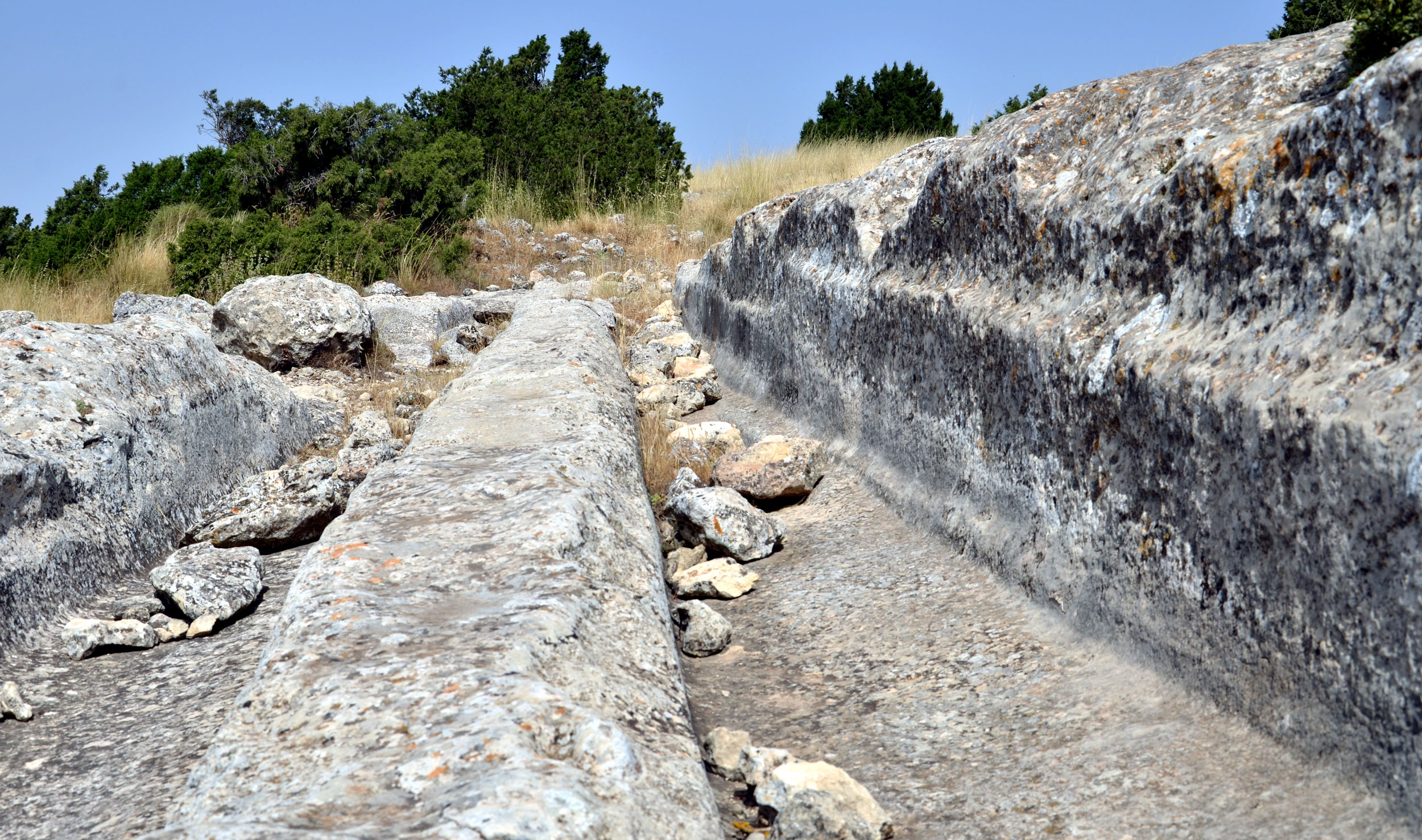
Image 12: A track at Castellar de Meca, Spain.
Photo by Uwe Schneider
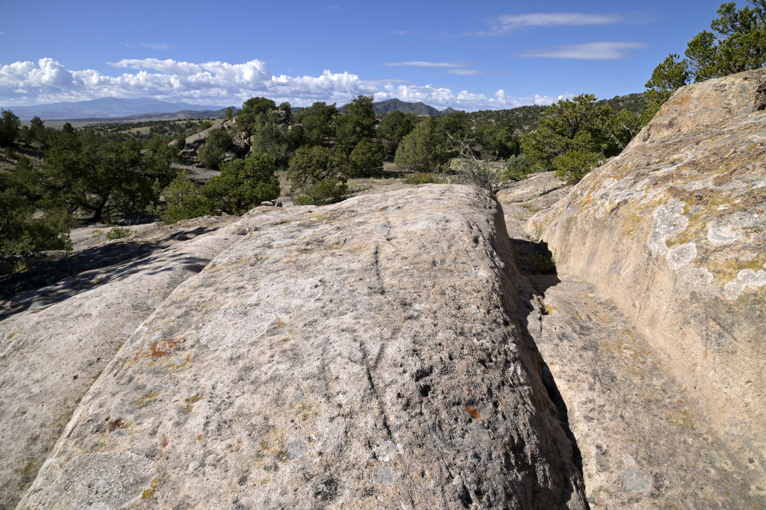
Image 13: A track near Del Norte, Colorado, USA.
Photo by Uwe Schneider
Another issue is the complete lack of any evidence of the animals often assumed to have pulled these carts. After ten years of research on this topic, I have never encountered a single track with signs of animal prints – not even faint ones. Instead, one frequently finds grinding or scratch marks in the centre of the tracks.
Cart-Ruts are frequently described as remnants of Roman trade routes, such as segments of the Via Domitia. However, one must question why these supposed trade routes did not evolve into larger roadways over time.
Moreover, especially in large areas with many tracks, there is no apparent logic to the track layouts. Their patterns resemble the chaotic markings of children’s games in sandboxes, of play, or of jumbled tracks found on military training grounds (see Image 14). Documented examples include Malta, Sicily and Sardinia (in Italy), France, and Anatolia.
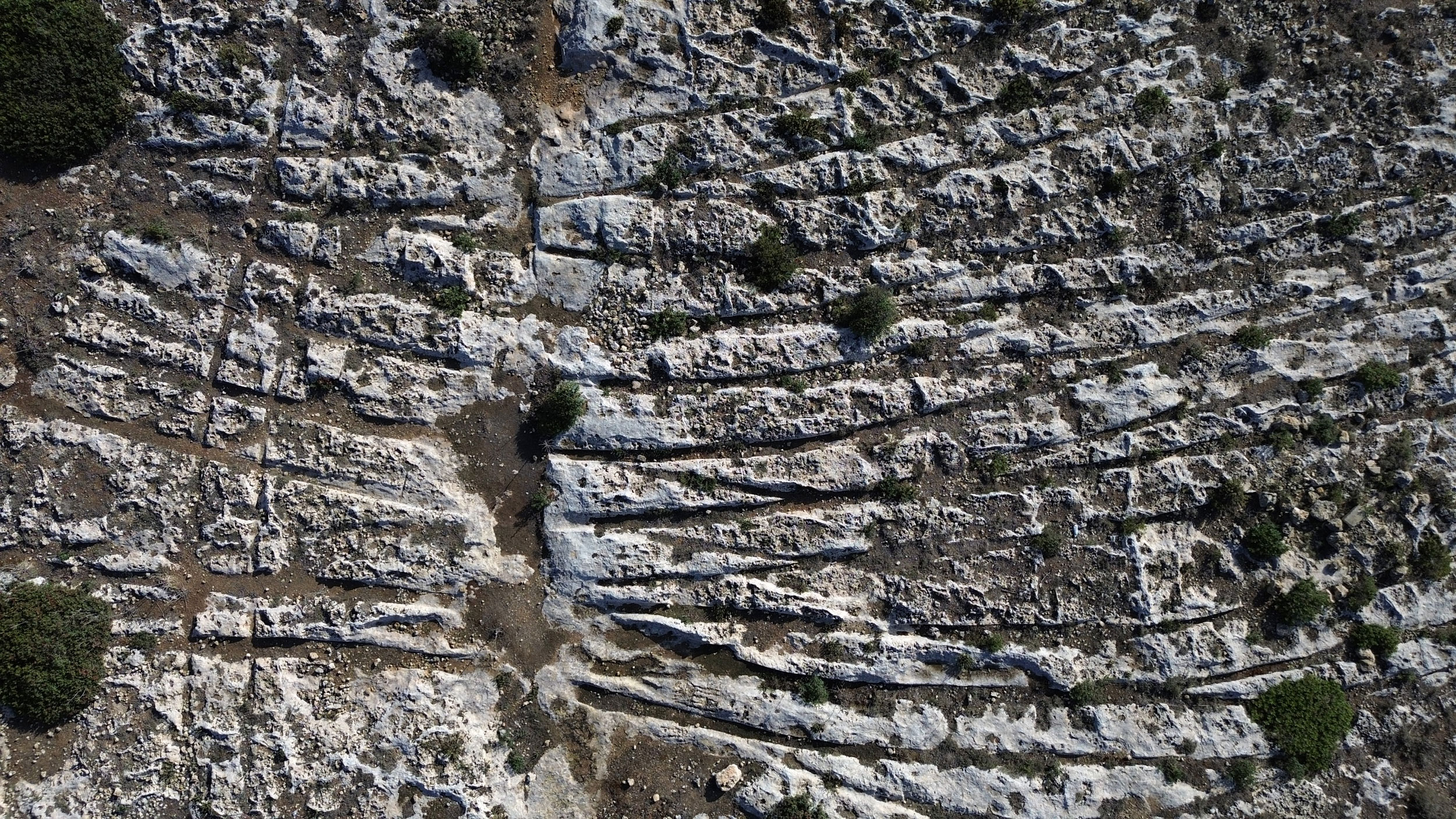
Image 14: Track chaos near Clapham Junction/Misraħ Għar il-Kbir, Malta.
Photo by Uwe Schneider
A further aspect worth scrutinizing is the significant erosion seen in some tracks. For example, on Malta, at a height of more than 100 meters above sea level, a track disappears off a cliff into the mists of the past (see Image 15). Older residents report that there were once Cart-Ruts on the small rocky island of Filfla, about five kilometres off Malta’s coast, which were bombed during military exercises.
Similar tracks that vanish at cliff edges can also be found in Spain and France. Far away, in Cappadocia, Turkey, home to the world’s largest areas of Cart-Ruts, the tracks often run for many kilometres, often broken up by valleys and lowlands caused by erosion.
Because of the morphology of these tracks, it is currently impossible to determine their formation process or even approximate age, as no comprehensive geological studies have been undertaken to date.
Image 15: This track vanishes above Gnejna Bay, Malta.
Photo by Uwe Schneider
Current State of Research
The advent of the internet has enabled me to access a great deal of relevant information from various sources, including insights from Uwe Topper, who explored this topic in the Mediterranean region decades ago and collected various data.
Topper reported that these tracks were already noted in Spanish literature as early as 1794. José Sabater remarked in 1877 that “these tracks will continue to haunt archaeologists for a long time.” Zuazo y Palacios, speaking of the impressive site at Castellar de Meca, once appealed to scientists and archaeologists alike, saying, “We consider these Iberian ruins among the most important in Spain!”
But why should Cart-Ruts be such a “haunting” mystery for archaeologists? I believe the unsettling element is that these tracks simply cannot be classified! They possess too many bizarre and entirely illogical characteristics that strain logical thinking and offer no clear solutions.
Nevertheless, archaeology has indeed taken an interest in this topic, although not to the extent it probably deserves. In 1893, Phillipp Ballif published a book titled “Roman Roads in Bosnia and Herzegovina”. The author travelled through the region, examining Roman roads and observed tracks in the surrounding area with typical Cart-Rut characteristics, which he attributed to Roman activity. The book contains images of heavily eroded grooves. However, no geological analysis or examination of erosion has been conducted (Roman Roads in Bosnia and Herzegovina, Philipp Ballif, Vienna, 1893).
In the 1950s, British archaeologist John Evans studied the Cart-Ruts on Malta and conducted experiments involving draft animals that dragged heavy logs across the landscape. According to David H. Trump, another British archaeologist who delved into the Cart-Rut mystery, Evans’s experiment was unsuccessful. Or perhaps it was successful, in that it demonstrated how difficult it is to create such tracks in hard limestone. Trump, displaying a touch of humour, suggested that the missing tracks of any animals pulling the carts could be explained by “flying geese” hitched to the carts instead. Trump also authored an insightful, if brief, book on Cart-Ruts in Malta, containing many photos and details on the topic.
In this work, Trump mentions that Abela (1649), Houel (1787), and Boisgelin (1805) also studied the tracks. He notes, “Definitive solutions seem as far away as ever.” (Cart-Ruts and Their Impact on the Maltese Landscape, David H. Trump, Malta, 2008).
Between 2000 and 2005, the EU’s CULTURE 2000 Programme funded research into Cart-Ruts by universities in Malta, Spain, and Italy. This research culminated in the publication of a book titled “The Significance of Cart-Ruts in Ancient Landscapes” (2005). The project analysed tracks in Malta and described two sites in Spain.
My impression is that although the publication addresses the topic at length, it does not address the fundamental need for geomorphological studies. Without such research, theories about the tracks remain speculative. I believe that geologists and geomorphologists first need to analyse the tracks to estimate their possible age in order to provide a foundation for further study.
One archaeologist in this publication proposed a theory that the tracks were agricultural in origin and possibly served as irrigation channels. However, after observing numerous tracks – including those in Malta – I find this theory entirely unrealistic.
In an archaeological work focusing mainly on the necropolises of Su Crucifissu Mannu in Sardinia, the Cart-Ruts, which resemble a rail yard in scale, are described as “transport tracks, likely created by rudimentary ‘carts’ used during Roman times to transport construction materials from the nearby town of Turris Libisonis.” Remarkably, many Cart-Ruts intersect with necropolises built later and attributed to the Ozieri culture, dating to approximately 3,500–3,200 BCE (Hypogäum V Von Montalé/Sassari, Nekropolen von Su Crucifissu Mannu/Porto Torres, Giovanni M. Demartis, BetaGamma editor 1999) (see Image 16).
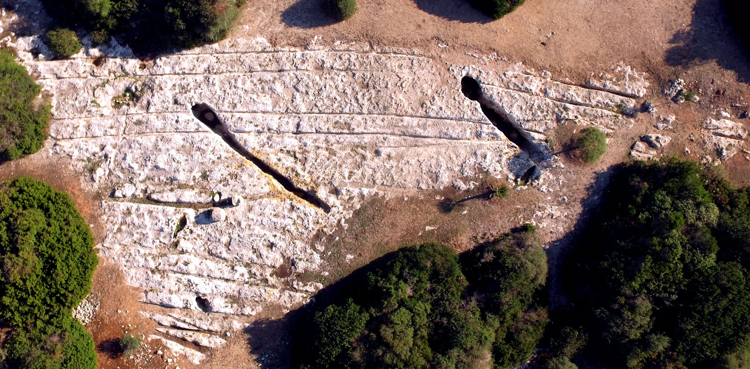
Image 16: Tracks interrupted by necropolises at the Su Crucifissu Mannu site, Sardinia, Italy.
Photo by Uwe Schneider
Since my 2015 expedition to Phrygia in western Anatolia, I have made various efforts to engage archaeologists and geologists in discussions, or at least to exchange views on this topic via email. The result, however, has been disappointing, with only a brief exchange of ideas with a staff member of the German Archaeological Institute (DAI) in Istanbul. Apart from that, there has been no substantive response. Given the open questions and the importance of the topic, this is hard to fathom.
At the DAI in Istanbul, the prevailing theory is that these tracks were created by carts pulled by oxen. Meanwhile, a well-known Turkish archaeologist emphatically assured me that they are traces from quarrying activities.
In the USA, Cart-Ruts are described as tracks left by settlers on their journey westward, caused by the sheer number of wagons passing over them. In an email, a geologist suggested that the tracks could be natural geological formations, similar to those sometimes found in karst areas.
In other words, there are still no conclusive research findings, leaving vast blank spots on the map of our past.
Conclusions
It is generally assumed that Cart-Ruts were formed by vehicles due to their morphology. This assumption is understandable, yet in my opinion, there is no conclusive evidence to support it. But if these grooves are not vehicle tracks, what else could they be? Unfortunately, this question is just as unfathomable as all the others that have been raised about this topic.
I believe one compelling reason to pursue intensive research is the remarkable similarities among tracks found on all continents. If these were simply the remnants of ordinary cart usage, they wouldn’t exhibit such striking, unusual patterns. Moreover, Cart-Ruts would be more widespread, given that carts were widely used and in operation for thousands of years. This suggests that we are dealing with an entirely misunderstood enigma from the past.
I believe future research should prioritise geological and geomorphological studies to provide a rough timeframe, which would enable an assessment of what was technically feasible in that period. Should the findings point to a very distant past, which I consider likely, it would challenge current historical narratives, prompting us to ask new questions with an open mind.
Additionally, specialists knowledgeable in stone-working are needed to understand how different types of rock respond to external forces. These tracks should also be examined by experts from the vehicle industry, as many of the Cart-Ruts are incompatible with known vehicle types.
I think this topic deserves more than a niche existence, as it represents completely unknown terrain on the map of history. In my view, these tracks are worthy of UNESCO World Heritage status! Sadly, some tracks are already being lost due to construction projects or are disappearing under rubble and concrete.
It is beyond my capacity as a private citizen to organise or fund geological and archaeological research. All I can do is continue gathering detailed information about the Cart-Ruts to demonstrate that similar tracks exist worldwide, suggesting an entirely unfamiliar chapter from a likely very distant past. Consequently, I am planning expeditions to Azerbaijan, Japan, and Anatolia in the coming years.
I believe that for a true understanding of the past, this topic requires serious and focused study.
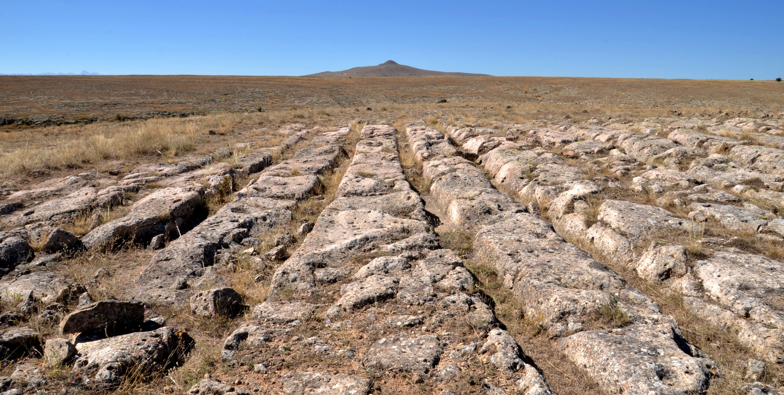
Image 17: The world’s largest Cart-Rut areas can be found in Cappadocia, Turkey.
Photo by Uwe Schneider
To conclude, I would like to mention a remarkable new finding: thanks to Google Earth, Andreas Pilz recently discovered extensive Cart-Rut sites in Apulia, southern Italy, which stretch for kilometres and bear a strong resemblance to the numerous tracks found in Turkey!
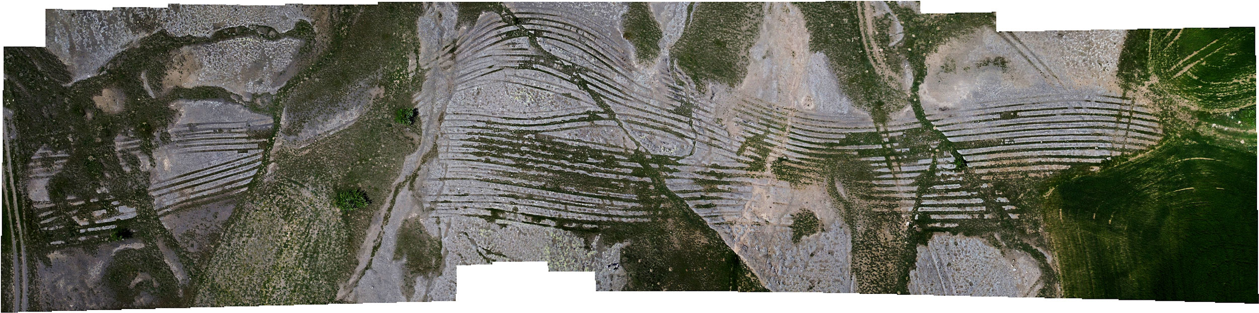
Image 18: Great art near Gesi Güzelköy/Kayseri/Turkey
Photo by Uwe Schneider
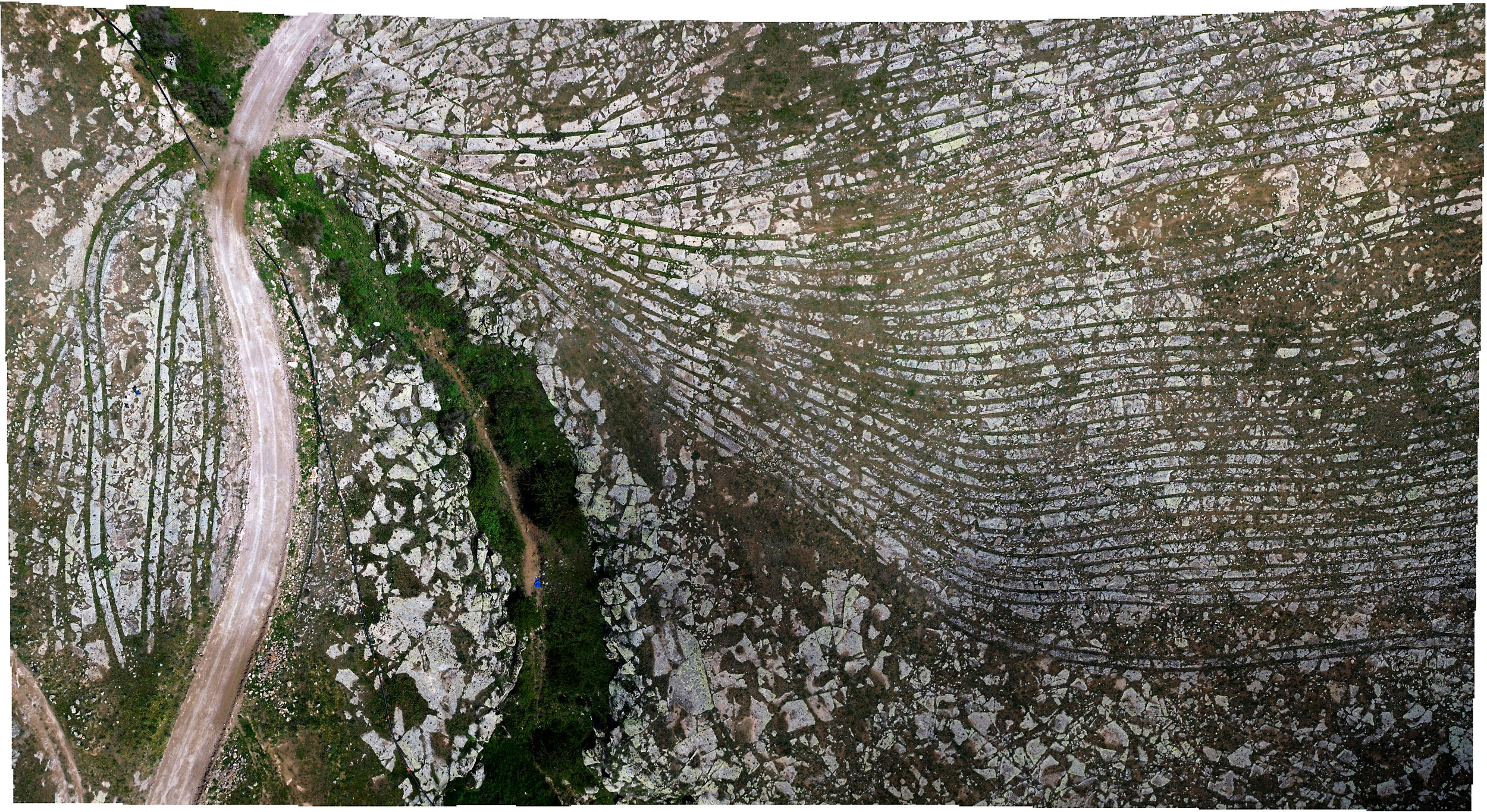
Image 19: A great area near Başköy/Cappadokia/Turkey
Photo by Uwe Schneider
Image 20: Beautiful traces at Güllüce/Central Anatolia/Turkey
Photo by Uwe Schneider
Image 21: Cart-Ruts in Kingman/Arizona/USA
Photo by Uwe Schneider
All coordinates of the tracks can be found on my website: https://www.cartruts.de/
Excellent summary.
These Cart Ruts have always fascinated me, with my background in geology, especially the ones found in igneous rocks.
It frustrates me that there seems to be no explanation for these but I also appreciate that you yourself do not try to explain them and stay impartial with your information. Hopefully with your hard work in studying these enigmas it will interest more qualified researchers and we can learn more about this mystery.
Thank you!
Así es Uwe. Es como si el tema fuese de segunda clase o un tema menor pero considerándolo en su terreno está a la altura en importancia del pasado a una Esfinge solo que a ras de suelo. Es tan misterioso o más que cualquier antigüedad que se levante dos metros del suelo. En cambio es un misterio de altura. Gracias Uwe.
Hallo Herr Schneider,
To me, the most revealing thing is that these identical cart ruts exist all over the world, proving that deep sea seafaring was practised in prehistoric times. Given these tracks and the megalithic structures, it is clear that it was not just a few traders crossing the Atlantic and Pacific Oceans. Rather, it was the exchange of goods and techniques. We must abandon the idea of isolated settlements and cultural centres of prehistoric societies.
In this context, please indulge me as I refer to the book The True(r) Prehistory. It essentially presents findings and facts proving a much earlier settlement and advanced civilisation, and calls for a rewriting of current official doctrine.
Mit freundlichen Grüßen,
Aloys Eiling
I live in Malta and have checked all the various sites out. For those in Malta: I am on the side, they were created for water capture and channelling in different ditections. Some obviously drainage. Would have been a series of wooden gates/sluices for management. There are always large manmade pools/cisterns connected to them. They always start from higher ground. (Good for water) Interestingly..!! They are always found near ancient underground dwellings – Malta has more than people realise. 😉 – some repurposed by later cultures as “catacombs”. Whoever was having to live underground, created them for water management to their dwellings and some agricultral efforts on the surface. How were they made? By removing the wheels from a cart and anchoring 2 large heavy stones (likely a harder stone type) in place. Throw some stones in the cart, get the oxen moving and grind yourself some “cart ruts”.! Same method using a ox pulled single blade plough for the many single cart ruts you find too. The simplest and most logical explanation for the Maltese cart ruts. Easy to create and manage. Water = survival.
I would like to ask you about the interior of these Maltese caves. Are there long tool marks on the walls?
Would be so amazing if a rover ran upon cart ruts on Mars.
The remains of drag-lines from surface mining lignite coal look similar. Perhaps they were dredging the surface looking for something. Fissures could indicate fault lines which could indicate underground water aquifers.
My theory
I propose that the paired grooves known as cart ruts are the preserved impressions of heavy sled transport made across soft, water‑saturated substrates that were rapidly hardened by a sudden environmental event. The sledways were impressed into mud or weathered calcareous deposits during repeated use. A fast hardening episode — climatic shock, rapid dehydration and cementation, hydrothermal pulse, or another high‑energy process — locked those impressions in place. Subsequent coastal retreat, erosion and sea‑level change exposed the hardened corridors while surrounding ground either remained lithified or was eroded away, producing the “frozen in time” networks we see today.
Formation sequence
1. Route selection and use I argue that prehistoric transport favored the easiest drag surfaces. People hauling heavy loads on sleds chose water‑softened corridors — mudflats, calcareous muds, or weathered tuff — because these substrates reduced friction. Repeated passages produced parallel grooves, central abrasion bands and variable gauges reflecting different sled types and loads.
2. Imprint accumulation Over many trips the sled runners and bracing elements produced characteristic micro‑and macro‑features: polished floors, parallel striae, central drag scars, and engineered cuts where obstacles were removed. The networks show overprinting and branching consistent with long‑term reuse and maintenance rather than a single linear road.
3. Sudden hardening event At some point after the tracks formed, a rapid hardening process affected the water‑saturated corridors. This process did not need to lithify the entire landscape — it only needed to cement or desiccate the mud corridors sufficiently to preserve the fine details of the sled impressions. The hardening could be driven by abrupt climate change (a rapid cooling/drying pulse), localized hydrothermal cementation, or another high‑energy phenomenon that produced fast mineral overgrowth or dehydration of the substrate.
4. Landscape evolution and preservation After hardening, normal geomorphic processes continued. Surrounding softer deposits were eroded, cliffs retreated and sea levels changed. The hardened sled corridors, being more erosion‑resistant, remained as erosional lags and now appear as continuous ruts that sometimes run off cliffs and continue onto submerged platforms.
Mechanisms that can produce rapid hardening
Selective substrate response
Only the sled corridors were soft enough to record impressions and only those corridors were saturated and compositionally predisposed to rapid cementation. Adjacent bedrock or dry ground did not record impressions and therefore shows no comparable preservation.
Possible hardening agents
Rapid drying and carbonate cementation in calcareous muds, producing micritic or sparry overgrowths that bind the fabric.
Hydrothermal or hot‑fluid pulses that precipitate silica or carbonate cements quickly in pore spaces.
Localized thermal events that alter mineral fabrics or drive recrystallization in fine sediments.
Electromagnetic or plasma‑related effects remain speculative but could be invoked where other evidence suggests unusual thermal or magnetic signatures.
Conclusion
This theory explains several otherwise puzzling features in a single, testable framework: why cart ruts are selectively preserved, why they appear “frozen” with fine detail, why they sometimes continue off cliffs into the sea, and why networks are complex and overprinted. The core claim is simple and falsifiable — sledways formed in soft, saturated corridors and were rapidly hardened by a discrete environmental process. The next step is targeted fieldwork and laboratory analysis to test the predicted mineralogical, chronological and geomagnetic signatures that would confirm or refute the model.
Wet or boggy surfaces are rarely ideal for a sled because the sleds runners sink into the soft surface. Once they sink it would be very difficult to move the sled.
Some of the ruts look like they are 2 or 3 feet deep, which means a sled would need runners at least 3 feet high. That would make them very prone to tipping over.
Where are the foot prints of whatever was pulling the sled? Pulling a sled would be very hard work, so we ought to be seeing some very deep foot prints, but I cant see any.
Sleds work best on a hard slippery surface. Ski’s compress snow into ice as they move across it, the same is true of sleds being pulled over snow. A sled on a soft wet surface is going to get bogged down.
I recently watched a good documentary about the “water‑saturated substrates” to which you allude. Filmakers showed samples of stone to several geologists, all of whom easily identified the samples as oolitic, which is laid down rapidly by water and then hardens. When the filmmakers told the geologists where the samples came from, all of them then denied the samples were oolites.
The problem being that the samples came from a lower layer in the Grand Canyon. This perfectly flat continuous layer of rock extends from half way into Mexico to halfway into Canada. The same layer, at the same level, is even found in Europe.
Upshot is that catastrophism and prior human activity absolutely MUST be denied no matter what.
So you have a good theory. Now prepare to be canceled.
I consider the theory involving sleds to be impossible. For one thing, many of the curves are far too tight, and for another, I would point to the many details surrounding the cart ruts.
And then we have the abrasion experiment conducted by Swiss researchers. Please take a look at the tracks, especially in Cappadocia and the Kayseri region. And most importantly, you have to see the tracks for yourself. I recommend
Cappadocia/Turkey or Valencia/Spain.
Best regards, Uwe Schneider
I did not realize how widespread cart ruts are around the world. It is a fascinating piece of our ancient puzzle. Thank you for sharing!
Thank god there are people like you and Graham that shine light on these kind of subjects! It’s been ignored for so long and it’s still not being acknowledged by “mainstream” archeology to be tracks of some kind of ancient vehicle or transporting system. Thank you!
Fascinating! Thank you!
Thank you for showing us.
I think these ruts are much older than anyone dares to believe.
Not all, but most of them appear to have been created by one pass, which suggests the ground was still soft!
You have shown us ruts that seem to go over cliffs, and we have even seen them going down into the sea.
Going over a cliff? Going down into the ocean? We seriously have to consider that these ruts could be millions of years old.
I do not believe they are made by cattle pulling carts. Some of those with scratch marks in between ruts look just like the marks left by the sump bolt of a vehicle going over soft ground.
Has anyone broken off a piece of the inside of a rut to check for organic matter incorporated into the stone matrix? The presence of organic matter would indicate a polymer, which would suggest that the ruts may be a byproduct of some stone softening chemistry being used by the locals for some yet poorly understood purpose. The more I look at he ruts, the more I see stone that has been gradually turned to mud and then re-hardened over time, as if some softening agent were on the wheels, and the sides of the vehicle. There are legends, particularly from South America, of a plant mixture that was used to soften stone for megalithic building projects such as Sacsayhuamán. I have also read that the H blocks of Puma Punku are quite possibly polymers due to the presence of organic matter incorporated into the stone.
Additionally, some of the tracks do have depressions between the “wheels” which would correspond to either human or animal feet that were similarly covered with softening agent. How it didn’t negatively affect feet and hooves, I have no idea, but none of the ruts look like they could have formed except in softened stone. I’m just not seeing carvings, especially in places where the tracks cut each other off, such as the Phrygian Valley in Turkey.
As for the very deep tracks, a softening agent could have the effect of deepening the tracks over time, making sections became unusable. This effect would likely continue, even in unused tracks, as the “mud” would tend to run downhill carrying away stone at a faster rate then natural erosion.
Just my two cents.
I have also read that the H blocks of Puma Punku are quite possibly polymers due to the presence of organic matter incorporated into the stone.