


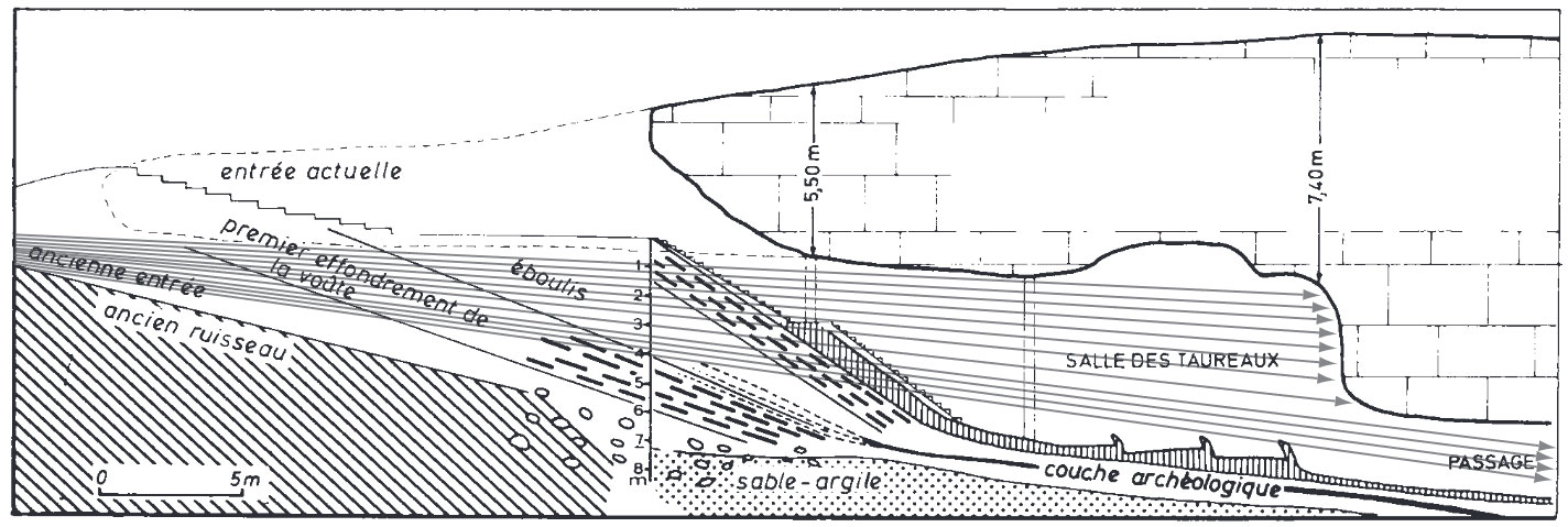
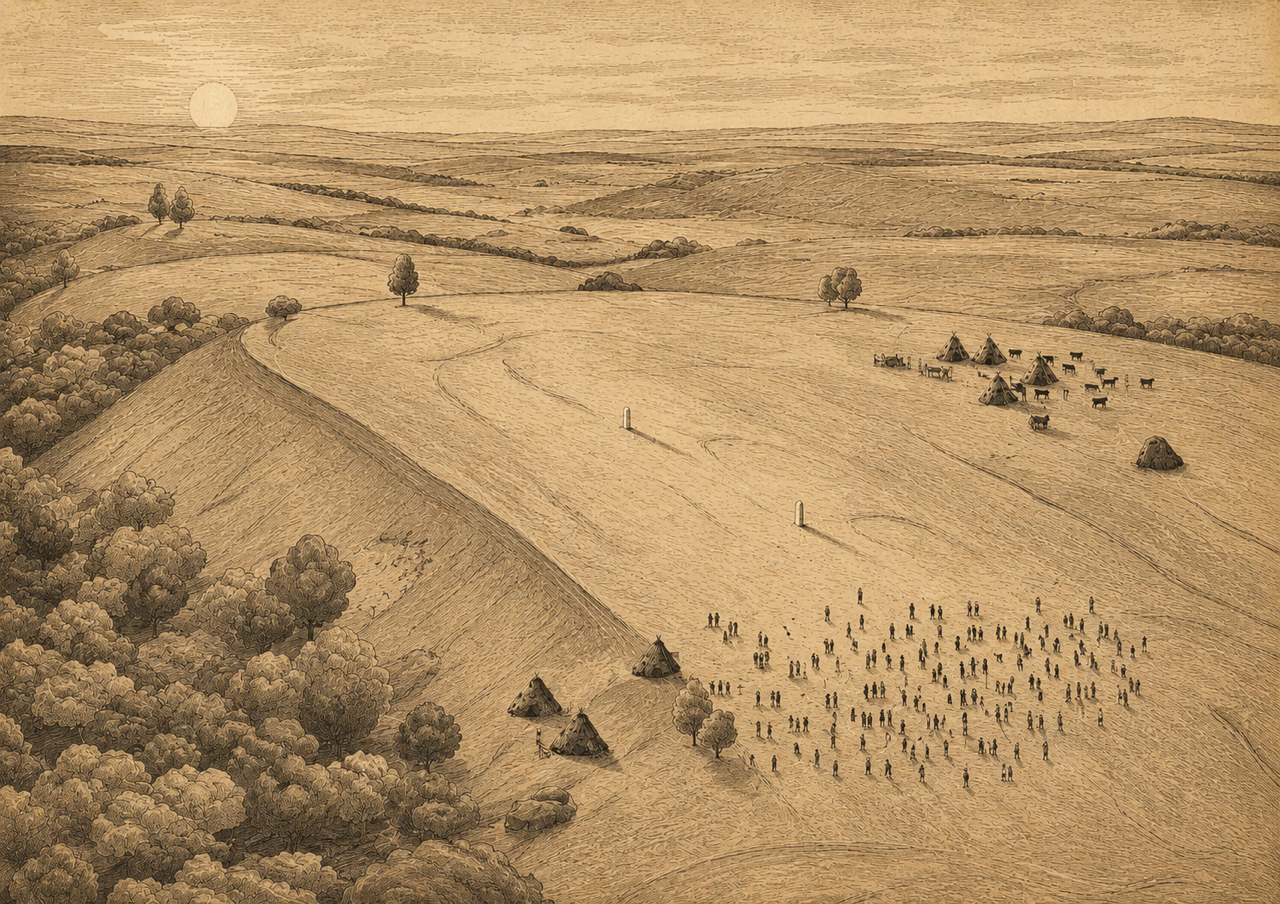
The winter solstice sunrise discovery at the Pre-Pottery Neolithic site of Karahan Tepe1 may not have been the first time the use of solar astronomy was recorded in stone. Observing the solstices is part of a much longer legacy dating back deep into the Upper Palaeolithic era (50,000 to 12,000 Before Present). The interiors of caves were being used as rock canvases in Western Europe, some with astronomical symbols, and often with entrances precisely aligned to the rising and setting sun on the solstices. Hunter-gatherer groups are now thought to have had a detailed understanding of the solstices and astronomy in general. This knowledge continued into the Pre-Pottery Neolithic in the Fertile Crescent, with sites such as Göbekli Tepe c.9600 BC, Karahan Tepe c.9400 BC, Jericho c.8300 BC and Atlit Yam c.7400 BC incorporating the solstices into their design. Furthermore, in Mesolithic Britain just over 10,000 years ago, the earliest inhabitants of the Stonehenge area in Wiltshire and Warren Field in Aberdeenshire studied the movements of the moon and the solstices, long before any ‘megaliths’ were put in place. This article looks at all these examples and questions why the solstice was so important to hunter-gatherers before agriculture was established, and re-evaluates the meaning of the Karahan Tepe winter solstice alignment.
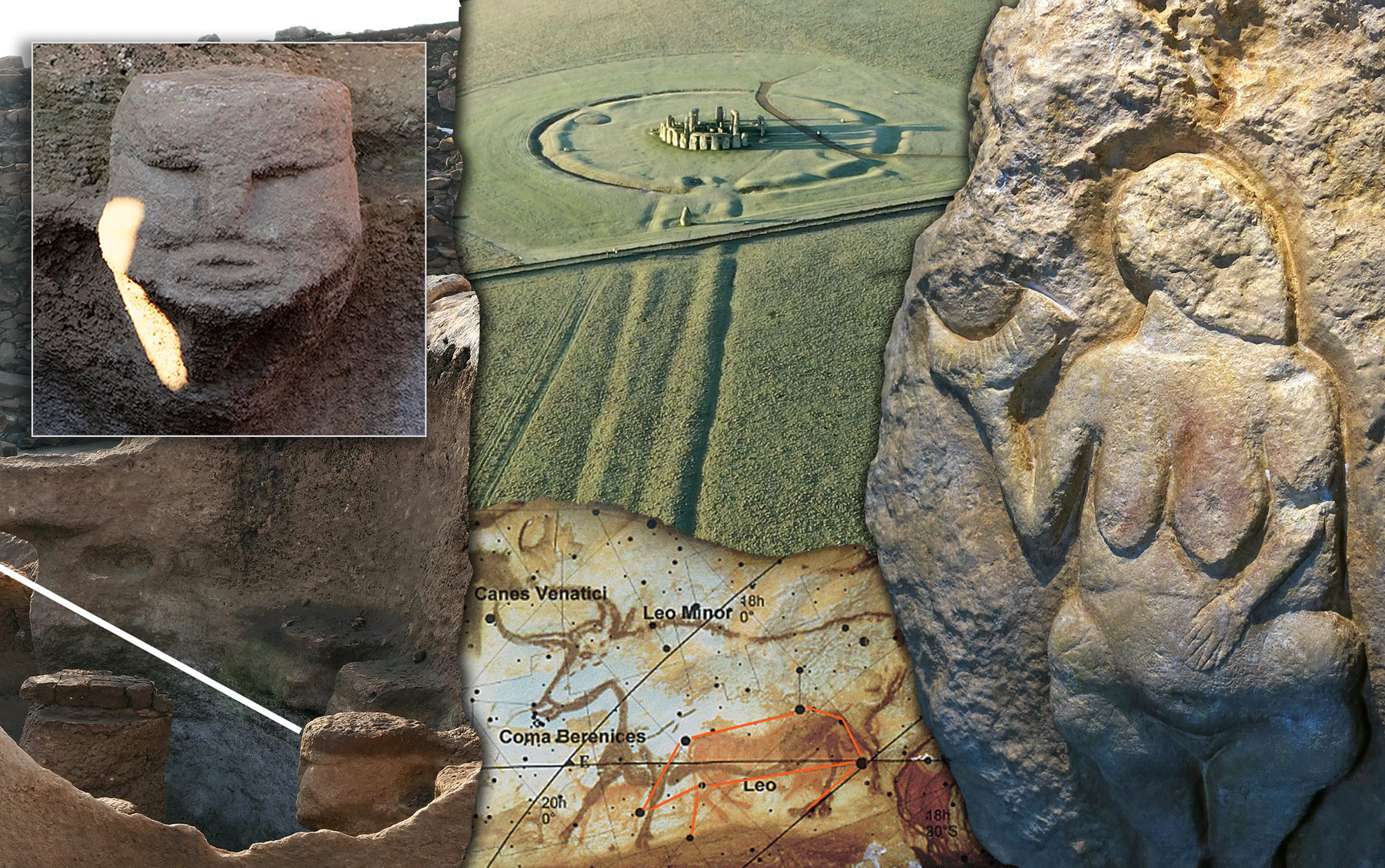
Stonehenge (top middle), Lascaux (bottom middle), Karahan Tepe images (Left), images: Hugh Newman. Laussel Venus, c.25,000 BP Venus (right) image: Don Hitchcock (used with permission).
Counting and the Moon
In The Roots of Civilisation (1972)2 Alexander Marshack studied hundreds of Upper Palaeolithic carved bone plaques, which displayed ‘time-factored’ notation systems, many linked to lunar calendars. His controversial book proposed that early hunter-gatherers were much smarter than the ‘savages’ they were usually depicted as. He found evidence of the tracing of the rhythms of the moon and sun, and other numerical calculations from the Upper Palaeolithic to the Mesolithic era. His research was much criticised, but opened the door for further investigations into who these people really were and how they thought. He believed their art contained narratives, symbolism and astronomical features, displaying an early form of science. Included in his research were perforated bone and ivory discs that may have acted as time-keeping devices. One reconstructed example was found to have 72 notches around the edge, 5° between each notch. 72 is a number linked to the precession of the equinoxes (see image further below).3 Although he stayed away from analysing the more famous cave paintings, his research had a lasting influence, highlighting the capabilities of people in this era and their fascination with recording the workings of the sun and the moon.
The notational systems that Marshack researched may also be present at Karahan Tepe. On top of the hill, a 6-foot-wide section of bedrock is decorated with multiple parallel lines in layers, with a notable serpent head at its base. It looks much like what he found on the numerous bone plaques, yet it has not been fully investigated or deciphered. Bahattin Celik first noted it in a paper in 2011, where he described what he saw as a “tally-like description”.4 If Karahan Tepe was a place to record the winter solstice, counting the days may have been an important part of time-keeping at the site. The section of bedrock is badly worn, so it is hard to determine the exact number of carved lines, yet it is has obvious similarities to numerous Palaeolithic and Mesolithic examples that Marshack interpreted as “notations made for calendrical record-keeping” or even ‘tallies’ for feasting gifts and debts often given away at large events centred around the solstices.5 This could well have been what was happening at Karahan Tepe.
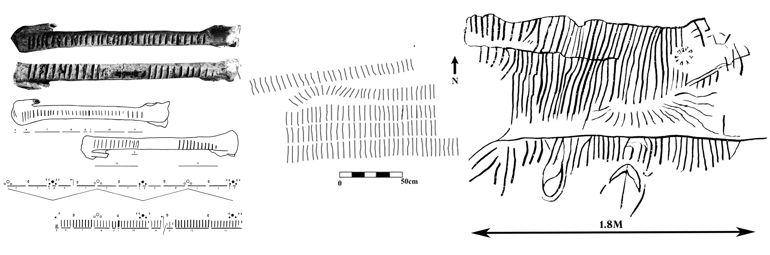
Left: A bone engraved on two sides from Fourneau du Diable, Dordogne, France. Dated to the Solutrean, c.21,000 to 17,000 years old. The engraved marks indicate possible lunar phasing. Image: Alexander Marshack. The Roots of Civilization: the Cognitive Beginning of Man’s First Art, Symbol and Notation. New York: McGraw-Hill. 1972 Middle: Lines and symbols carved into the bedrock at the peak of Karahan Tepe, reported by Bahattin Celik, 2011. Image: Bahattin Celik. Karahan Tepe: a new cultural centre in the Urfa area in Turkey. p.250 Right: Hugh Newman’s illustration adapted from a 3D lidar scan.
Sefer Tepe lies a few miles north of Karahan Tepe and was in use during the Pre-Pottery Neolithic B (c.8500 BC). Numerous T-shaped pillars have been found in situ along with dozens of beautifully crafted artefacts. One of these pieces is a 6cm-wide limestone disc discovered in 2022, which has 13 circular peck marks in different configurations on both sides, possibly representing the number of full moons or new moons in a calendar year.6 Linear notches are also carved between these circles on the flat side of the disc.
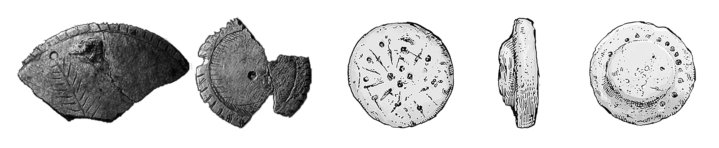
Left: Engraved and perforated discs from Mas d’Azil, France, 19,800 years old, between 8cm and 10cm wide. The example on the left would have had a total of 72 notches around the circumference. Image: Chantal Jègues-Wolkiewiez – Paleolithic techniques and tools used to calculate space and time, Part 3. 2012 Pleistocene coalition news, VOLUME 4, ISSUE 1 JANUARY-FEBRUARY 2012. Right: Small limestone disc from Sefer Tepe, 6cm diameter, with 13 circles on both sides in different configurations. Artwork by Dan Lish (used with permission).
Cave Art
The Upper Palaeolithic cave paintings of Western Europe give a fascinating glimpse into the artistic mindset of the creators. Lascaux is one of the later-occupied caves, dated to approximately 17,000 years old, although evidence of human activity reaches 21,000 BP.. It was discovered in 1940 by four local boys and investigated by archaeologist Henri Breuil, nicknamed the ‘Pope of Prehistory’ (as he was also a Catholic priest). Breuil initially believed that the symbols could be representing constellations.7 This idea was further developed in the 1990s when Spanish prehistorian Luz Antequera Congregado noticed that the seven dots, along with the auroch image, could represent the Pleiades cluster and the Taurus constellation.8
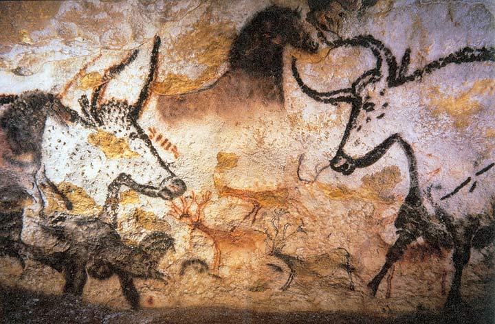
Lascaux Aurochs, Horses and Deer, photo Prof saxx (CBYSA3.0)
The depictions of certain astronomical features in Upper Palaeolithic cave art have been noted by several other researchers over the last few decades. French archaeoastronomer Chantal Jeguès-Wolkiewiez proposed that the ‘Hall of the Bulls’ was a primitive ‘Zodiac,’ and more recently, Dr Martin Sweatman of Edinburgh University has found correlations between the cave art of the Lascaux ‘shaft scene’ and symbols on Pillar 43 at Göbekli Tepe, which he published in his book, Prehistory Decoded (2017).9
Enter the Solstice
The symbolism of the cave paintings is hard to decipher, but when Chantal Jeguès-Wolkiewiez continued her studies of Lascaux, finding specific solar alignments in relation to cave entrances and their interior paintings, a new line of enquiry was opened. Over a seven-year period, she visited 130 caves and found that 122 of them aligned to the solstices or equinoxes, which is well beyond the realm of chance.10 The comparison to later Neolithic and Bronze Age megalithic sites is of interest here, because it was for a long time thought that such orientations were primarily used for agricultural purposes, but this has now been turned on its head. The solstice, it seems, had another function for hunter-gatherers.
None of the caves that were studied had a clear view of the sky above (as though they were roofed), yet in some cases, their entrances allowed light in on these particular turning points of the year, which would illuminate the paintings. For example, the Abri Castanet Rock Shelter (37,000 BP), and Bison Cave (33,000 BP) are illuminated during the winter solstice sunset; Lascaux and Bernifal Caves on the summer solstice sunset, and Blanchard and Combarelles Cave-I on the equinoxes, although a majority of the studied caves orient to the winter solstice sunrise.
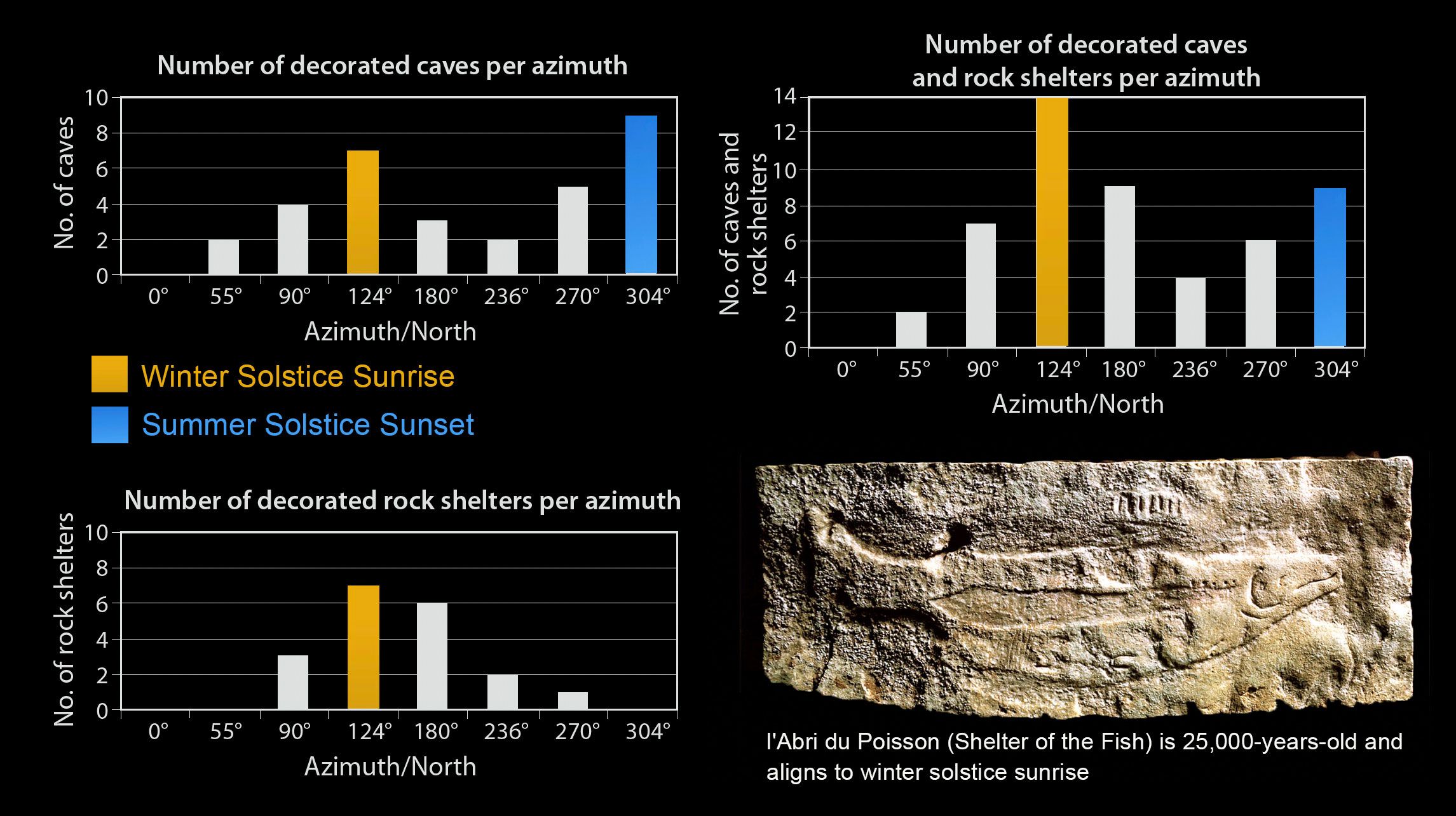
Data obtained by Jègues-Wolkiewiez indicate that the entrance orientations of decorated caves and rock shelters in the Les Eyzies-de-Tayac, Dordogne region strongly cluster towards the rising or setting positions of the sun at solstices. Inset: l’Abri du Poisson Cave aligns to the winter solstice sunrise. Photo Heinrich Wendel (CCBYSA4.0)
“Chantal Jeguès-Wolkiewiez has argued that certain caves and rock shelters in the Upper Palaeolithic were decorated and used for rituals because their entrances were aligned with solstice and equinox positions of the sun. In her sample, undecorated caves and rock shelters show no such preferential orientations.”11
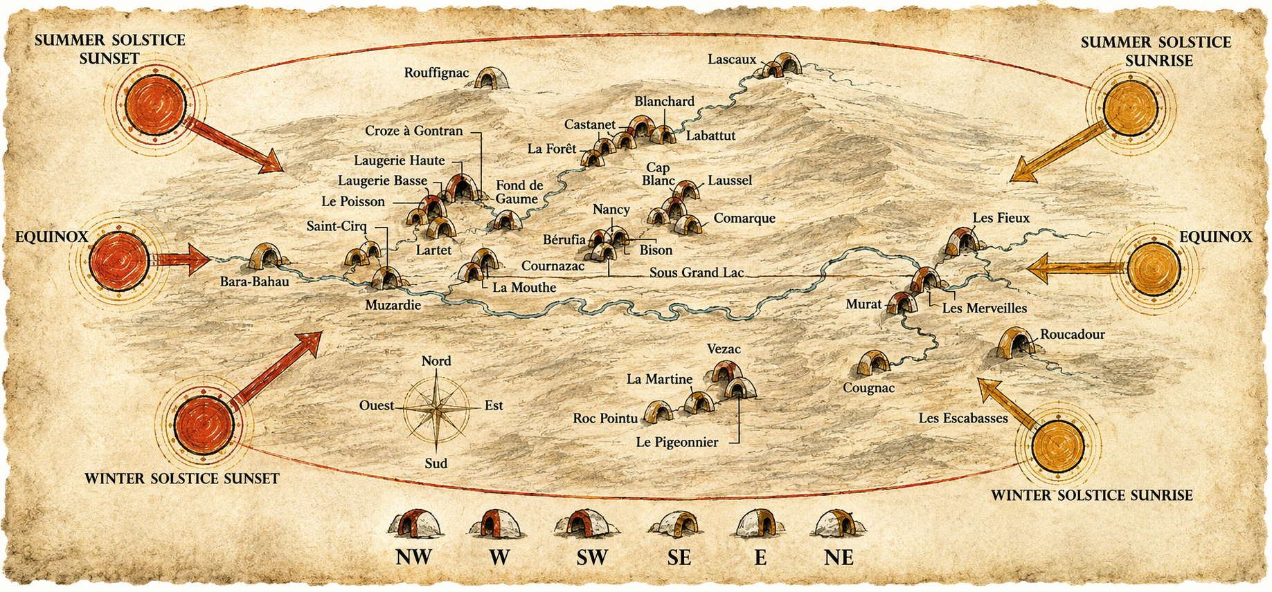
Map adapted showing the solstice and equinox orientations of painted cave entrances in the Dordogne region of France. Adapted from Chantal Jeguès-Wolkiewiez by Hugh Newman
The obliquity of the ecliptic has slightly altered the sunrise and sunset positions over the millennia, but the Lascaux alignment still works, as it is only just over 1° difference. The summer solstice sunset still illuminates the cave entranceway, which leads to the ‘Hall of the Bulls.’ It has also been noted that the orientation of the entrance is 3° south of the summer solstice sunset position. However, when taking into account the slight slope at the entrance, it was found to give a clear illumination lasting for 50 minutes, and could be viewed for several days over the summer solstice (due to the ‘standstill’ of the sun during this period). Jeguès-Wolkiewiez also confirmed from a visit in December 1999 that light from the full moon during midwinter would also illuminate the paintings (the moon follows the same path of the sun at the opposite side of the year).12
Lascaux lateral section drawing showing the slope angle that the sun shines through to illuminate the painted areas. Image by Brian Hayden and Suzanne Villeneuve, 2011 (https://doi.org/10.1017/S0959774311000400), after Leroi-Gourhan, 1979 and Chantal Jeguès-Wolkiewiez, 2000.
L’Abri du Poisson (Shelter of the Fish) was discovered in 1892 and is located on the banks of the Vézère River in Dordogne. A low-relief of a salmon nearly 1 metre long (3.2ft) was found engraved on the ceiling, with its lower jaw appearing to be ‘pulled back’. This unique characteristic is, in fact, what happens to male salmon in the breeding season, which takes place in December. This cave is 25,000 years old and is aligned to the winter solstice sunrise when the interior gets illuminated.13 Marshack found further calendrical motifs that appeared to reflect the seasonality of fish mating, and also deer molting and vegetation sprouting.14
Furthermore, the stunning 3D relief of the Venus of Laussel from the same era was found carved in a cave that orients to the winter solstice sunrise. This goddess carving has in its right hand an unusual ‘horn’ with 13 markings on it, perhaps representing the number of full or new moons in a solar year.15 Further goddess figures were found in the cave, as well as the Laussel Priapus, from a Gravettian layer (22,000 BP); a male fertility idol with a large, erect phallus. These 3D relief carvings were not only placed in a cave that orients to the winter solstice sunrise, like at Karahan Tepe, but they also echo the stone carving style that dominated Taş Tepeler sites thousands of years later.
Further north, similar astronomically oriented caves highlight how widespread this knowledge was: “Long-distance movements and a dispersal of cultural influences were clearly present during this [Magdalenian 17,000 – 12,000 BP] period… On the Russian plain … there were summer and winter sites along [the network of rivers that flow toward the Black Sea], including riverside sites that were specialised for seasonal resource exploitation and for seasonal symbolic performance and production.”16
Throughout the world, hunter-gatherers understood the extreme north and south rising points of the sun on the horizon. Their observations eventually enabled them to align their cave entrances, record the ecliptic, depict constellations, and even develop a ‘zodiac’, all painted accurately on the ceilings of caves during this era. These traditions reached far and wide before influencing the Pre-Pottery Neolithic zone of Southern Turkey.
“Recognition of the ecliptic and the construction of a zodiac to monitor solar, lunar and planetary movements entails fairly sophisticated astronomical concepts and has often been considered the hallmark of complex literate societies.”17
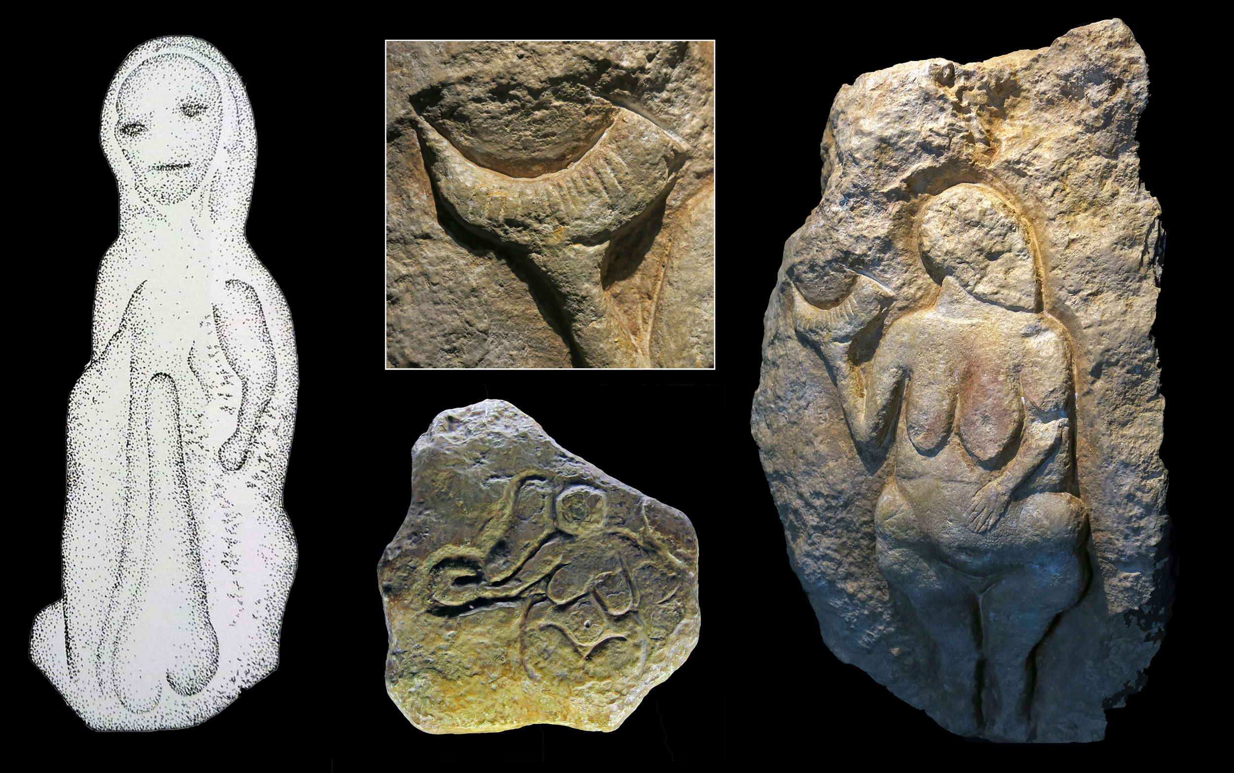
Artefacts from the Laussel Cave, including the Laussel Priapus (left), a goddess figure c.32,000 BP (bottom) and details of the Laussel Venus, c.25,000 BP (right). Images: Don Hitchcock (used with permission).
Hunter-Gatherer Star-Watchers
The implications of these discoveries were developed further in Astronomy in the Upper Palaeolithic? By Brian Hayden and Suzanne Villeneuve (2011), who also took a close look at ethnographical studies of hunter-gatherer groups from around the world and their relationships to the sky.18 They collected information on hunter-gatherers, outlining what they called ‘simple’ and ‘complex’ group types, where the latter were categorised into the following:
- relatively high population densities;
- seasonal or full sedentism;
- individual or family control of products and some productive resource areas (private ownership);
- storage (controlled by individuals or families);
- significant socioeconomic differences within communities (often reflected in burials);
- trade and the creation of prestige objects based on surpluses;
- competitive displays and elaborate feasting activities based on surpluses;
- bride prices or dowries together with enhancement of the value of individual children;
- attempts by elites to control access to the supernatural;
- hierarchical and heterarchical sociopolitical organisations based on economic production;
- complex counting systems that extend into the hundreds or thousands.
From these, “80 per cent of the groups (63 of 79) exhibited some solstice observation or monitoring and/or calendars (most often lunar)….In all of the 63 groups, it was the winter solstice that appeared to have played an important role in terms of celestial observations, in commencing the year, rituals, dances and feasts, or in some cases food restrictions.”19 In most cases, a shaman or priest was in charge of monitoring the solstice, and determined the calendar feast dates, rituals, dances and ceremonies. Disputes would often arise regarding choosing the correct timing for these events, and meetings of these elders would have to take place to acquire accurate data, developing an elaborate system of solar astronomy over many generations.
“Moreover, aggrandizers in complex hunter-gatherer societies often form ‘secret societies’ in which esoteric astronomical knowledge is developed. The existence of calendrical notations and secluded meeting places for secret-society members are suggested to be at least plausible interpretations for a number of Upper Palaeolithic caves and images.”20
One of the hunter-gatherer groups in the study was the Chumash people of southern California, who had a secret society called the ‘antap. They were a prestigious group that included chiefs, their families, and religious specialists. The highest-ranking position was the Sun Priest, who was also the head astronomer, who maintained careful observations of the sun and used precise solstice points to make adjustments to their calendar. The Sun Priests would go inside mountain caves at solstice sunrises, which contained solar and celestial rock-art associated with vision quests. They also stored their ritual paraphernalia in these caves.21
Other hunter-gatherer groups in North America followed similar solstice activity. This kind of knowledge was always kept secret, and only the assigned elites would have the training and understanding to maintain their connection with the movements of the heavens. This ‘training’ would be a long-term endeavour, much like we find with the carved bone plaques of the Upper Palaeolithic era, where one person would have to make daily etchings at specific times to complete the notation of lunar movements, which could last for months, even years. This was not an idle pastime. Time-keeping was an esteemed role in the community that was generational and required specialist effort.
“Somewhat speculatively, we might suggest that if some Upper Palaeolithic caves were being used in a fashion similar to the ‘antap use of caves by secret societies (i.e. for some of their more important rituals or initiations), then using them at key solstice times of the year, when the sun would shine into their entry chambers, could have formed part of the supernatural ‘secrets’ of the societies that possibly constituted visible proof of the depth of their knowledge of the supernatural world, both in the upper (celestial) and lower (underworld) cosmos. Privileged visitors from other communities and new initiates could probably have been awed at the more spectacular celestial events played out in the entryway of some caves, not to mention in inner chambers where dramatic decor created by powerful secret societies could have constituted visible proof of their knowledge, power and wealth.”22
This could be what we find at Karahan Tepe, where the stone head in Structure AB would become illuminated at this important time of year. It can be imagined that the astronomer-priests of Karahan Tepe would be seated on the western edge of the main enclosure, and only the Sun Priest and privileged visitors would be allowed to go into the Pillars Shrine to observe the movement of the blade of light across the face on the winter solstice morning. Structure AB may also have been covered over, creating a cave-like environment.23
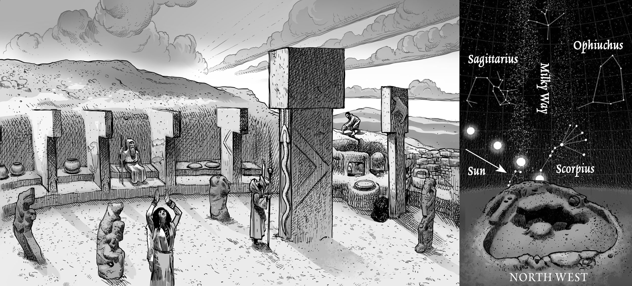
Imagined ceremonial scene from Karahan Tepe. Inset: Andrew Collins discovered that the Milky Way rises vertically 2½ hours after midsummer sunset in 9000 BC above Structure AA. Artwork by Dan Lish (used with permission).
“Astronomical and calendrical knowledge, at least at the level of detailed solstice monitoring, was a recurring feature in many complex hunter-gatherer groups and continued to be a major feature in more complex societies from the dawn of agriculture to the first high civilizations.”24
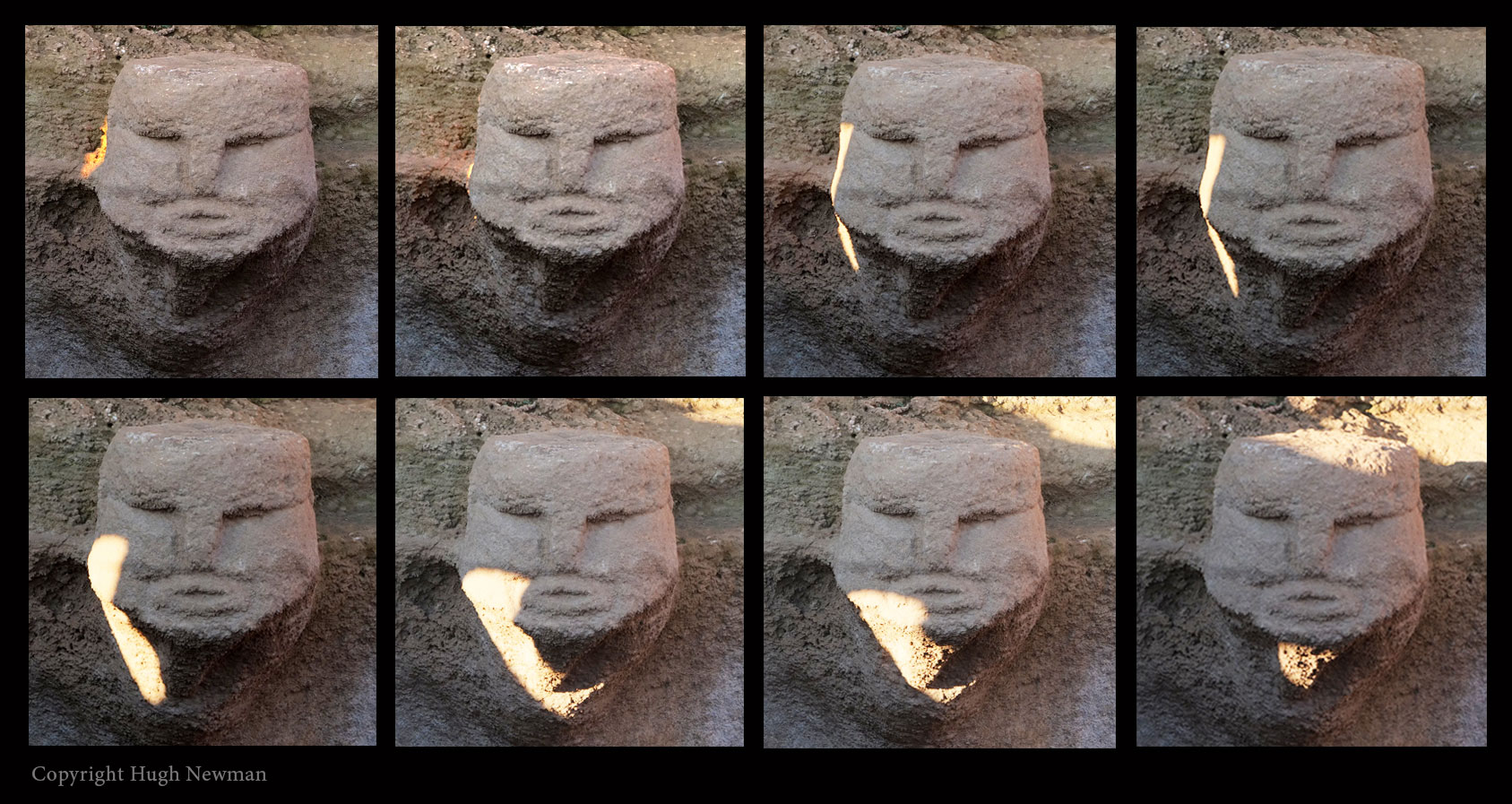
The 45 min sequence of the light phenomena on December 21st 2022 at Karahan Tepe. Photos: Hugh Newman.
This partly correlates with Dr Lee Clare’s idea of three types of ‘charismatic leaders’ at Göbekli Tepe: the ritual adept, the storyteller and the hunter.25 The role of the ‘ritual adept’ was essential to the community, being in charge of scheduling ceremonies, initiations and rituals, and therefore involved in recording time. They also acted as the connection between this world and the world of the ancestors. However, in Clare’s hypothesis, there is no mention of any form of astronomy, or the fact that anthropological studies of hunter-gatherer groups routinely had connections to the solstices. This is partly due to the misleading roof hypothesis that has been put forward (with little evidence) by E. B. Banning26 and others,27 and therefore, because there were roofs, the archaeologists believe these people didn’t look towards the sky or study the movements of the sun. In a previous article, the author and JJ Ainsworth challenged this simplistic notion, as it simply does not fit with the data.28 Karahan Tepe has a profound winter solstice phenomenon built carefully into the site, which, although ignored by the archaeologists, has been proven to work with and without a roof, and can still be directly observed every single year.
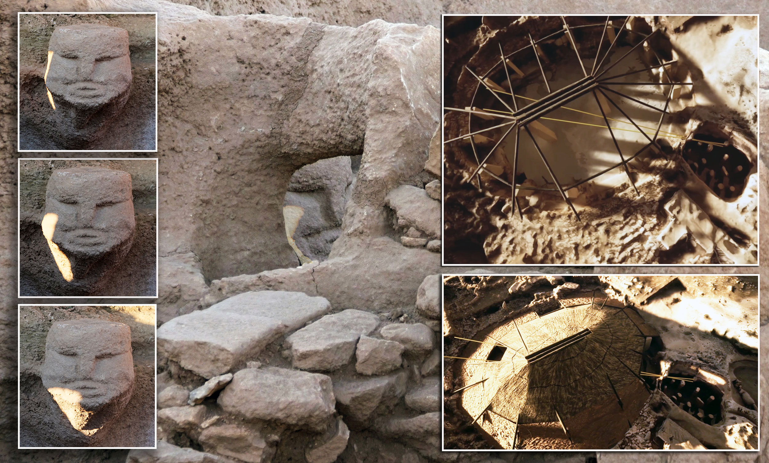
The Karahan Tepe winter solstice alignment with roof reconstructions on the right. Images: Hugh Newman and Kevin Eslinger (used with permission).
The Pre-Pottery Neolithic Solstice
Now it has been proven that the winter solstice sunrise was an established alignment at Karahan Tepe, and there is a long history of studying the solstices from the Upper Palaeolithic era, are there any other Pre-Pottery Neolithic sites that incorporated this knowledge?
Göbekli Tepe has two enclosures that could arguably have solstice alignments. Enclosure D, dated to 9600 BC in the southeast depression and Enclosure F on the southwestern slope are separated by about 100 feet of distance and 800 years of time, F dating to around 8800 BC. Enclosure D is rich in astronomical iconography and symbolism and has already been put forward as being an observatory. Andrew Collins claims the mean azimuth of the central pillars of Enclosures D orient towards the setting of Deneb, the brightest star of Cygnus in the north.29 Italian archaeoastronomer Giulio Magli believes it was constructed to follow the rising of Sirius in the south.30 JJ Ainsworth sees it in a slightly different light, with the combination of these ideas into a hypothesis that they were basing their star observations of the Golden Gate of the Ecliptic, which will be covered in detail in a future article.
In 2024, a carved slab of stone with intricate reliefs was found in the southeastern wall of Enclosure D.31 It is located precisely in the direction of winter solstice sunrise at the time of its construction (if viewing it from between the central T-pillars). It has a central H in relief, and a sharp C (looking like an inverted V) on its left and an inverted C on the right. The horizon in this direction is also clear of obstructions, and the winter solstice sunrise could easily have been observed between two of the outer T-pillars (like at Karahan Tepe). We can speculate that the H may represent two upright pillars and the horizon between them, as that is exactly what you see when looking in this direction.

Main image: Enclosure D at Göbekli Tepe showing the solstice orientations and the inverted V symbol from a slab (no.7), which shows the angles between the summer solstice and the winter solstice sunrises. Adapted from Dr Lee Clare, 2024 (CCBYSA4.0). Inset: The main enclosures with their orientations, notably Enclosure F, which has a summer solstice sunrise and winter solstice sunset angle. Inset diagram: Andrew Collins (with permission).
When placed over a plan of Enclosure D, the carved inverted left V also gives us the angle between the midsummer sunrise and the midwinter sunrise for the dates of Göbekli Tepe.32 This, of course, could be a coincidence, yet Pillar 30 marks the summer solstice (which has an inverted H on it) and the stone slab marks the winter solstice. More research needs to be carried out on-site, and it must also be determined if this stone slab was, in fact, one small part of a full-sized porthole stone.
Enclosure F is oriented west-southwest to east-northeast to within a degree of the rising of the sun at the time of the summer solstice, and in the opposite direction, to the winter solstice sunset. Its azimuth is 59°, which would give a relatively clear view of the horizon where this would have taken place during the era of Göbekli Tepe.33 There are no porthole stones which could help prove this was designed to observe the solstice, but it was constructed after Karahan Tepe, where solstice observations were already established.
Solstices in the Levant
Jericho (Tell es-Sultan) is famous for its giant walls and stone tower and is located east of Jerusalem, with continuous occupation since Pre-Pottery Neolithic times. It had a giant rock-cut ditch, was the first city in the world, and was occupied by many cultures, starting with the Natufians. The Jericho Tower dates back 10,300 years. In a 2008 paper, Roy Liran and Ran Barkai from Tel Aviv University analysed the position of the tower in relation to the summer solstice sunset and got some astonishing results.34 The interior stepped passage of the tower orients to azimuth 290° (or 20° north of west). At this time, the summer solstice sunset would have illuminated the passage of the tower. In some ways, this could be a representation of being in a cave. However, it’s a bit more complicated than that.
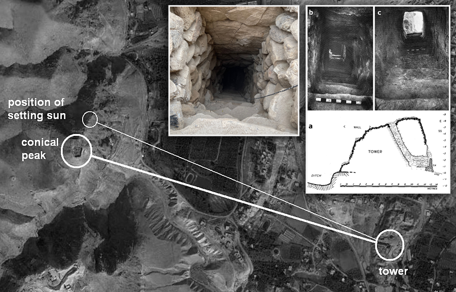
Jericho’s summer solstice sunset astronomical alignment.
Black and white images courtesy of Ran Barkai (used with permission). Top Center image Hugh Newman.
“In a recent paper we have suggested that the tower’s alignment was with geographic and celestial contexts. It was connected with the nearby Quruntul summit by building a straight staircase pointing at the peak. Additionally, the axis created by the tower, stair and mountain has the exact azimuth (290°) of the setting sun during Jericho’s summer solstice, supporting the idea that the builders used the tower as a link to the cosmos. The tower and wall were built to mimic the mountainous ridge to the west, and to provide a suitable setting for experiencing the summer solstice.”35
Constructing the Jericho tower would have been a massive building project, and at this time, they were certainly hunter-gatherers. As we have seen, it could have been the central focus of their community and served as a continuation of what their Upper Palaeolithic ancestors had been passing down for generations.
Discovered in the 1980s, Atlit Yam is a submerged late Pre-Pottery Neolithic B (and C) complex, situated 300 ft offshore and 40 ft underwater off the Northern Carmel coast. It is dated to between 7250 and 5970 BC and is the largest site of the dozens of studies off the same coast. Its notable feature is a semi-stone circle with cup-marks on it, as well as “a wall built of mud bricks, pairs of parallel walls, paved floors, water wells, hearths as well as about 20 round storage and production installations made of undressed stones.”36
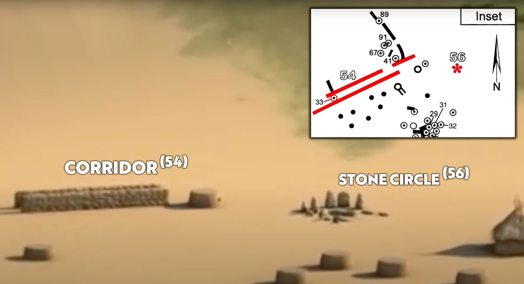
The summer solstice sunrise alignment at Atlit Yam marked by red lines along the double wall. Image: M. Sibson (used with permission).
Next to the semi-stone circle, these parallel stone walls are up to 30m (95ft) long, which align with the summer solstice sunrise. British Archaeoastronomer Clive Ruggles confirmed that the two corridors at Atlit Yam were: “oriented in the direction of sunrise on the June solstice.”37 Notched artefacts have also been unearthed, suggesting they were day-counting. Altit Yam existed some 2000 years after Karahan Tepe, so it being aligned to the summer solstice is not unexpected. However, it demonstrates, like at Jericho and Karahan Tepe, that communities maintained the tradition of keeping their alignments prominently marked in their settlements.
The Astronomers of Mesolithic Britain
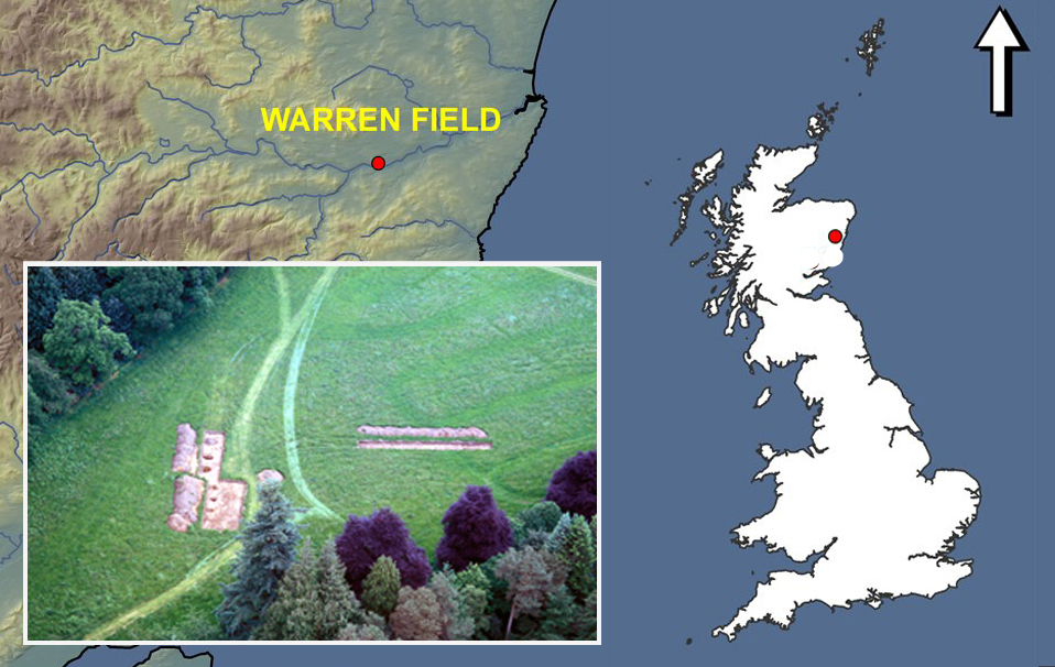
The Mesolithic era of Britain had some hunter-gatherer astronomers of its own. Just over 10,000 years ago, the people of Stonehenge in Wiltshire38 and Warren Field in Aberdeenshire,39 utilised large wooden posts and landscape features to determine the movements of the moon and the solstices.
The Warren Field ‘Time-Reckoner’
The northerly location of Warren Field is striking because the ice sheets (in 8000 BC) started retreating from this area of Aberdeenshire before most of the rest of Scotland, meaning this area was a place to freely roam, hunt, gather food sources and observe the sky.
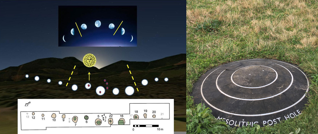
Left: The Warren Field lunar calendar with the winter solstice sunrise. Gaffney et al, 2013 (CCBY3.0)
Right: One of the Stonehenge post holes from the Mesolithic era. Both sites date back to 8000 BC (Photo Hugh Newman).
The site is comprised of a series of 12 pits in a gentle curve facing the area of the midwinter sunrise and the waxing and waning moon. According to archaeologist Vince Gaffney, these could represent the 12 lunar months, and the winter solstice would “calibrate” the calendar due to the fluctuations of the moon during the solar year. Next to the central circle number five, three small post holes are located, which have not been explained, but could simply be there to mark the winter solstice sunrise and the fact that it rises in the same position over several days, before returning north on the horizon in the proceeding days.
Location map of Warren Field with inset showing excavation at the site. Gaffney et al, 2013 1, 2 (CCBY3.0).
It is also just south of the Hill of Fare, which was the sacred mountain of the Bronze Age megalith builders, who constructed the famous recumbent stone circles of Aberdeenshire. It is also located near the 6000-year-old farm at Balbridie, one of Scotland’s oldest Neolithic settlements, where some of the earliest evidence of agriculture was found in the British Isles.40 We can certainly speculate on the possibility that the Warren Field calendar helped initiate these innovations.
Although artefacts are rare at Mesolithic sites such as Warren Field, Star-Carr in Yorkshire stands out. Ceremonial and animistic beliefs may have played a role in their culture. “These incredibly rare finds include headdresses made from red deer skulls, thought to be used by shamans in ritual practices, barbed points (harpoons) used in hunting and fishing, the ‘oldest house in Britain’, and the earliest evidence of carpentry that we have in Europe.”41
The ‘Star Carr Pendant’ was found at the site in 2015 and has been described as the oldest Mesolithic art in Britain. It is made from shale and has tally marks and a perforation, resembling Alexander Marshack’s ‘time-factored’ notation systems.
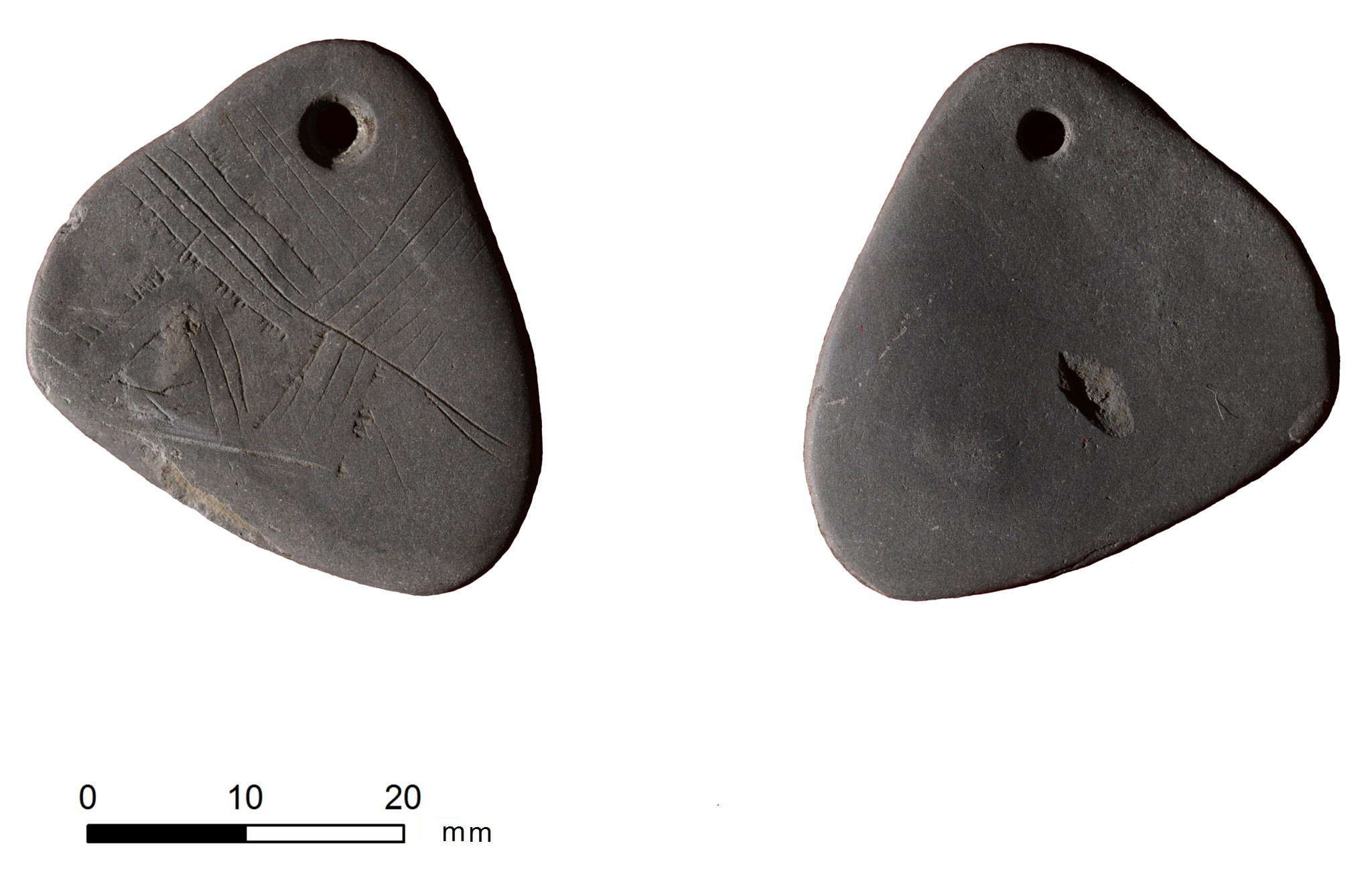
The ‘Star Carr Pendant’ is a unique engraved shale pendant from the Mesolithic site of Star Carr in North Yorkshire, England. It has been described as the oldest Mesolithic art in the British Isles. Image Milner et al, 2016 (CCBY3.0)
The First Stonehenge
Stonehenge is famous for its summer solstice sunrise alignment, which is still celebrated today. Every year on June 21st, thousands of people come together to celebrate this stunning solar display. From within the centre of Stonehenge, the sun rises over the distant Heel Stone, which sits on the path of the earthen Avenue oriented to the north-east, the midsummer sunrise position. However, when Stonehenge was being built around 2500 BC, the land had already been in use for 5500 years, and even back then, the summer solstice (and winter solstice) may well have been observed by the local people at that time. Let’s begin our analysis, not in the centre of Britain’s national temple, but just to the northwest in an unlikely place, the former ‘Stonehenge car park’.
Discovered in 1967, three early-Mesolithic pits (A, B and C) were excavated under the car park at Stonehenge, within 150m – 200m of the centre of the later-constructed stone circle. A further pit was identified 100m to the east/southeast in 1988. The true age of the post-holes was not known about for some time, and this is where the story gets interesting. Cecil Newham, before he knew about the extreme antiquity of the post-holes, calculated that their positions were astronomically significant. He was assuming that Stonehenge existed contemporaneously with the former pine posts (which were estimated to be up to 30ft /9m high) and worked out numerous astronomical alignments based on what he knew at the time. Newham’s data was drawn from the position of the Heel Stone (which marks the solstice alignments) and the four station stones outside the main circle.42 Whether any of these were here in Mesolithic times is unclear, although it’s entirely possible they started experimenting on the landscape to develop their astronomical skills at a very early date. After the carbon-dates confirmed that the post holes date to 8820 BC – 6500 BC, his theories were overlooked. However, the exact location of Stonehenge was in fact being utilised during the Mesolithic era, so his theories are returning to the spotlight, but from a slightly different perspective.
The Avenue marks out this summer solstice sunrise (and also the winter solstice sunset in the opposite direction). It was long thought that the parallel ditches and banks were placed there after the construction of the stone circle to mark the solstices. Since excavation in 2008, however, when a section of the Avenue was opened up, this has now been turned on its head. The findings revealed, “that large and deep periglacial fissures running parallel with the much later Avenue, are fortuitously aligned on the midsummer solstice sunrise and the midwinter solstice sunset.”43 This axis may have been further emphasised by two mounds marking each end of the periglacial stripes. ‘Newall’s Mound’ is located on the ‘elbow’ of the Avenue to the northeast, made up of deposits of clay and flints. The other is within Stonehenge itself, on the southeastern area of the Trilithon Horseshoe. It was here in 2008 that archaeologists Timothy Darvill and Geoffrey Wainwright unearthed pine charcoal dating back to 9330 – 9070 years old,44 placing the location of Stonehenge firmly within the Mesolithic. These mounds could be partly natural, but even if they were, their locations appear to have been significant to the people of the area.
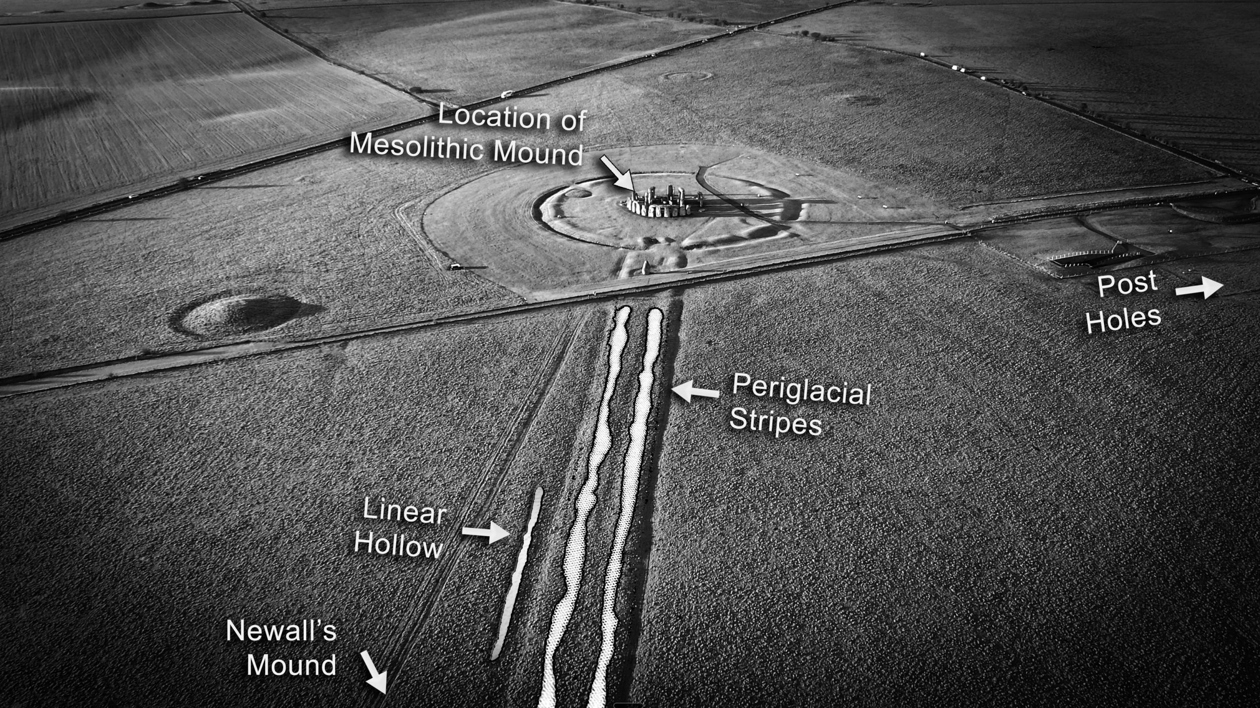
Stonehenge showing the Mesolithic mounds, post-holes, solstice-oriented periglacial ridges, and a linear hollow that would later become the ‘Avenue’. Image by Hugh Newman
The geology auspiciously assisted in Salisbury Plain becoming an important part in the development of astronomical observation in southwest England. It has been known for some time that these periglacial stripes perfectly aligned to the solstices, but now with mounds on either end, it becomes clear the primary orientation was looking from Newall’s Mound up to the mound in Stonehenge, as it would have created a perfect horizon with a clear ‘bump’ marking the position of sunset on the shortest day of the year. Both directions could have been observed over the solar year and must have been important landscape features to the Mesolithic people at this time.
Archaeologist Mike Parker Pearson and his colleagues have given “cosmogonic significance to the location.” They suggest, “A long-term history of gatherings at the Stonehenge locale throughout the Mesolithic would have created a network of well-worn paths and routeways all leading towards it. In the same way that all roads led to Rome, all paths in the earlier Holocene of central southern England might have led to Stonehenge, or rather to the nearby springheads and valley sides of the Avon.”45
At this time, a flint knapping site and natural spring called Blick Mead was starting to be used, where “large Mesolithic gatherings and extravagant feasts”46 became commonplace in the land next to the water source. Drawing groups from as far afield as Wales and Sussex, they may well have been spending time making astronomical observations over many generations. Flint could be acquired and processed at Blick Mead, natural water sources abounded, and it was a known hunting zone. All this, along with giant wooden posts marking the area like beacons, Mesolithic Stonehenge was apparently thriving and sowing seeds of ideas that would come to full fruition some 5000 years later.
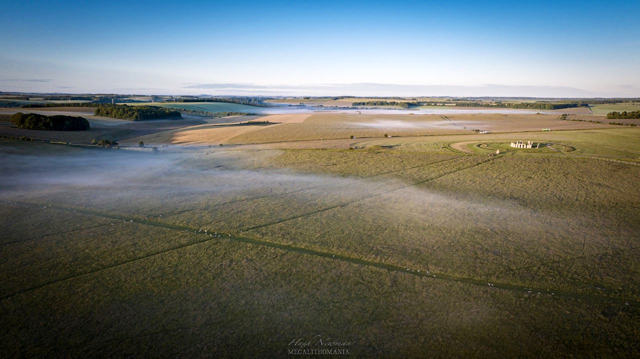
Aerial photo of Stonehenge showing the Avenue, which was once a natural feature in Mesolithic times Photo: Hugh Newman.
In June 2026, archaeologist Phil Harding (formerly of Time Team) and his team from Wessex Archaeology uncovered more wooden post holes, but this time they appear to be an astronomical “prototype” of Stonehenge within 3 miles of the structure, dated to just before the construction of the stone circle (c.3000 BC). Located near Bulford, the discovery consisted of two timber poles 120 metres apart that align with the summer and winter solstices (within 1 degree), according to archaeoastronomer Dr Fabio Silva. It appears to have been built approximately 500 years before the great stone circle was erected, suggesting that the legacy of solstice observation from the Mesolithic era to the construction of the stone circle now has a new addition slotted into the timeline.
The Bulford summer and winter solstice alignment marked by the newly discovered wooden posts which dates to 500 years before Stonehenge. Image by Hugh Newman.
No doubt more Upper Palaeolithic and Mesolithic discoveries like the ones discussed in this article will come to light, but for now, these examples of solar alignments from an earlier era certainly suggest that the builders of Karahan Tepe were part of a long legacy of very capable and intelligent hunter-gatherers, who had a tremendous understanding of the movements of the sun. We can now get a sense of the mindset of the Taş Tepeler people, as anthropological data, along with this worldwide understanding of studying the movements of the sun, has revealed that this was not an idle, monotonous pastime, but rather a long-standing tradition, embedded with initiation, ceremony and feasting. Observing and studying the sky played a significant role in the mindset and cultural advancements of the Taş Tepeler people, but it was the hunter-gatherer groups before the Pre-Pottery Neolithic era, across the Upper Palaeolithic world, who originally developed a substantial understanding of the solstices long before the agricultural revolution, and their insights and ingenuity created a remarkable legacy that is still being celebrated today.
Hugh Newman is the author of Göbekli Tepe and Karahan Tepe: The World’s First Megaliths (Wooden Books 2023). He is an explorer, co-founder of the Megalithomania Conference, and tour/expedition leader. He has appeared on the History Channel, Discovery, Gaia TV, the Smithsonian Channel, and the Science Channel. He lives near Stonehenge in Wiltshire, UK. megalithomania.co.uk
© 2026 Hugh Newman. The author would like to thank JJ Ainsworth, Andrew Collins, Dr. Martin Sweatman, and Prof Vince Gaffney for their help with this article. Thanks to Don Hitchcock and Dan Lish for photos and artwork.
References:
- Hugh Newman and JJ Ainsworth. Secrets of Karahan Tepe: The Discovery of a Stunning Winter Solstice Alignment. https://grahamhancock.com/newmanainsworth1/
- Alexander Marshack. The Roots of Civilization: the Cognitive Beginning of Man’s First Art, Symbol and Notation. New York: McGraw-Hill. 1972.
- Chantal Jègues-Wolkiewiez. Paleolithic techniques and tools used to calculate space and time, Part 3. Pleistocene coalition news Vol 4, issue 1, 2012
- Bahattin Celik. Karahan Tepe: a new cultural centre in the Urfa area in Turkey. p.250
- Brian Hayden and Suzanne Villeneuve. Astronomy in the Upper Palaeolithic? Cambridge Archaeological Journal , Volume 21 , Issue 3 , October 2011. DOI: https://doi.org/10.1017/S0959774311000400. p.332
- Hugh Newman. Göbekli Tepe and Karahan Tepe: The World’s First Megaliths. Wooden Books 2023. p.43
- Alastair Coombs. Stone Age Stellarium. 2018. https://alistaircoombs.com/2018/08/13/stone-age-stellariums/
- Luz Antequera Congregate. Art and Astronomy, Evolution of the Drawings of the Constellations. 2000. Complutense, SA
- Martin B. Sweatman. Prehistory Decoded. Troubador Publishing. 2018.
- Chantal Jeguès-Wolkiewiez. Cro-Magnon: premier astronome de l’humanité? Science et vie 2007: pp.93-101
- Hayden and Villeneuve. 2011. p.350
- https://web.archive.org/web/20040611215439/http://archeociel.com/lascaux.htm
- http://histoiredutemps.free.fr/terrestre/hominide/cro.magnon.htm#cr1
- Michael Hudson. After the Ice Age: How Calendar-keeping shaped Early Social Structuring. (UMKC) in Paul G. Bahn, ed., An Enquiring Mind: Studies in Honor of Alexander Marshack. American school of prehistoric research monograph series, Oxford and Oakville: Oxbow Books, 2009. pp.149-53
- William Irwin Thompson. The time falling bodies take to light: mythology, sexuality, and the origins of culture. New York: St. Martin’s Press. p. 105. 1981
- Hudson, 2009. p.150
- Hayden and Villeneuve. 2011. p.346
- Hayden and Villeneuve. 2011. p.340
- Hayden and Villeneuve. 2011. p.336
- Hayden and Villeneuve. 2011. p.331
- Hayden and Villeneuve. 2011. p.339
- Hayden and Villeneuve. 2011. p.350-351
- Andrew Collins. Karahan Tepe: Civilization of the Anunnaki and the Cosmic Origins of the Serpent of Eden, Andrew Collins. 2024. Inner Traditions, USA. www.innertraditions.com/karahan-tepe. p.114
- Hayden and Villeneuve. 2011. p.340
- Lee Clare. Inspired individuals and charismatic leaders: Hunter-gatherer crisis and the rise and fall of invisible decision-makers at Göbeklitepe. 2024. https://doi.org/10.4312/dp.51.16
- E. B. Banning. So Fair a House: Göbekli Tepe and the Identification of Temples in the Pre-Pottery Neolithic of the Near East, Current AnthropologyVolume 52, Number 5. 2011. www.journals.uchicago.edu/doi/10.1086/661207
- Prof. Neci Karul quoted in Debunking claims about Göbekli Tepe, By Koray Erdogan. 2024. www.turkiyetoday.com/culture/debunking-claims-gobeklitepe-75895/
- Hugh Newman and JJ Ainsworth. Reconstructing Karahan Tepe’s 11,400-year-old Winter Solstice Alignment. December 2024
- Andrew Collins. The Cygnus Mystery. Watkins Publishing. 2006.
- Magli, G. Sirius and the project of the megalithic enclosures at Göbekli Tepe. Nexus Netw J 18, 337–346, 2016. https://doi.org/10.1007/s00004-015-0277-1
- Lee Clare. Inspired individuals and charismatic leaders: Hunter-gatherer crisis and the rise and fall of invisible decision-makers at Göbeklitepe. 2024. https://doi.org/10.4312/dp.51.16
- Göbekli Tepe’s Stunning New Discoveries 2024, Taş Tepeler Update. Video on MegalithomaniaUk Youtube Channel. https://youtu.be/gS_CBwKbc7E
- www.andrewcollins.com/page/articles/Karahan.htm
- Ran Barkai and Roy Liran. Midsummer Sunset at Neolithic Jericho. Time & Mind. Vol 1, Issue 3. 2008. pp.273-284.
- Ran Barkai and Roy Liran. 2008. pp.273-284
- Ehud Galili, Liora Kolska Horwitz, Vered Eshed, Baruch Rosen, Israel Hershkovitz. Submerged prehisotric settlements off the Mediterranean coast of Israel. Skills Journal. Vol.2. 2013. p.183.
- Archaeoastronomer Clive Ruggles in The Mystery of Atlit Yam Documentary, Jean Bergeron 2014. However he states it is the summer solstice sunset in https://link.springer.com/chapter/10.1007/978-3-030-37367-2_23.
- Cecil Augustus Newham. The Astronomical Significance of Stonehenge, 1972. J. Blackburn Pub.
- Vincent Gaffney et al. Time and a Place: A luni-solar ‘time-reckoner’ from 8th millennium BC Scotland. 2004. https://doi.org/10.11141/ia.34.1
- www.heraldscotland.com/news/homenews/21859258.balbirdie-ancient-site-reveals-neolithic-farmers-avoided-manure/
- www.starcarr.com/history.html.
- Cecil Augustus Newham. The Astronomical Significance of Stonehenge, 1972. J. Blackburn Pub.
- Mike Parker Pearson, Joshua Pollard, Colin Richards, Julian Thomas, Chris Tilley, and Kate Welham. Stonehenge for the Ancestors, Chapter 1: Before Stonehenge: The Mesolithic and Early Neolithic. Leiden, The Netherlands: Sidestone Press. p.23
- Timothy Darvill and Geoffrey Wainright. 2009. Stonehenge Excavations 2008. The Antiquaries Journal 89: pp.1–19
- Mike Parker Pearson, Joshua Pollard, Colin Richards, Julian Thomas, Chris Tilley, and Kate Welham. Stonehenge for the Ancestors, Chapter 1: Before Stonehenge: The Mesolithic and Early Neolithic. Leiden, The Netherlands: Sidestone Press. p.23
- https://archaeology.co.uk/articles/features/blick-mead.htm.
- https://www.newscientist.com/article/2530818-ancient-monument-may-have-been-an-early-stonehenge-prototype/
Interesting that the light appears first at the ear, and finishes with the throat. Hearing, and then speech or song. Perhaps this related to something, a cosmogeny, a magical or mystical doctrine, a ritual structure, a metaphysic?
That is interesting. In the pantheon, the ears and the eloquent speaker or speech, are antipodal when in a circular format.
Lord Rayleigh , author of “The Theory of Sound” born on the exact day of the ears. The guy who did the magnificent work on Echolocation in Bats and Whales, Roger Payne, also born on the same day, as was Munch, painter of “The Scream”.
The antipodal position, is the day of sacred expression. Water , voice, and verb.
Certainly ideas to consider. The fact that it has an open mouth and the eyes appear to look towards the porthole stone suggests this could be some form of narrative encased in stone.
Great stuff Hugh. That disc with 13 holes would make a perfect hand held time keeper for anyone keeping the trecenas or even the entire 260 day calendar. Pegs in the holes. 20 trecenas of 13 days each. The thing that really helps track that cycle, is animal behavior. This even to the point, that if you lose track, you can get back on it, by watching the animals or humans. What this means, is that you can identify the day out of the 20, and then the trecena (if you lost that), can be detected over a couple rounds.
The one suitable purpose is simply keeping men out of the doghouse with the ladies. In tight quarters over a long winter that can be life preserving. There’s a trigger alert day for that.
But in hunting, the animal behavior is understated, because you must hunt carefully, not aggressively if you want to keep the game local. My time as a youth spent hunting , fishing and trapping, is absolutely invaluable to keeping the days.
I always like to bring up that Stone Henge was found to be tracking the 36 decans also. In those they are very much separate as a set of identifiers as the sun signs. They get specific even in body shape.
The female figure (everyone calls Venus) is almost certainly born in Dec 21 – 31. It is one of the easiest body shapes to identify birth time in the pantheon. The back goes straight to the thighs and the breasts are large.
The time keepers, and the astronomers are two different groups just as they are today. When they both combine with the story tellers you get master level text and stories.
I feel pretty strongly that the 20 days would be identified before the decans, and they come with the trecenas, because the 13 day burst is quite noticeable. It isn’t that hard to follow the carry over of the day the #1 lands on.
The first 20 hexagrams of the I-Ching are the twenty days, and they are highly developed. Being tailored to advising the ruler, one better be correct, so if we take the dating of that as 7,000 years old, then the days are much older. I do not believe the I-Ching could have been developed the way it is, without thousands of time keepers. The decans are 21-56.
The teaching has to be strict, because new students get excited and want to claim new findings. That phase lasts about 5 years depending on the student. Then , it tails off and the realization of the thorough nature of the ancestors findings becomes stark. 20 years, I have nothing to add yet. It speaks of comprehensive and detailed chewing on the information by many intelligent people.
I have yet to find the decans without the days. We need a Chronobiologist timekeeper. Sociologists and Anthropologists also. It seems we have the astronomy taken care of.
I have been told by one chronobiologist that many domestic animals have a 20 day menstrual cycle, but I don’t track that. There is much to do.
Thanks for the stuff.
Fascinating, thanks for this info, David.