


Article updated 12 May 2025 to include acknowledgement of Luigi Usai’s findings. Originally published 13th March 2025.
Introduction
Humanity has always shared a profound, unbreakable bond with water. We build our lives along its shores, draw sustenance from its depths, and trace our stories by its edges. A shoreline on a map isn’t just a line—it’s a frontier that has guided our survival and sculpted the course of history. The Mediterranean Sea, with its vast, shimmering reach, has long been a cradle for civilizations and a wellspring of enduring myths. Yet there’s a persistent chasm between the oral traditions we’ve inherited and the physical evidence of the past, leaving most of these tales dismissed as mere fantasy. Beneath those calm waves, however, lies a discovery that could challenge our understanding of the Mediterranean’s shifting boundaries and open a window into a forgotten chapter of humanity—one that might finally reconcile the threads of legend with the truths of history.
A Link to the Deep Past
In November 2024, while generating topographic maps in QGIS for my book on Atlantis, I uncovered something truly extraordinary. I was tracing what I believed to be an ancient shoreline, a line where I had long suspected there might be a slim chance of finding evidence. Yet, I had all but abandoned hope, convinced that time, combined with the limitations of resolution, had buried any traces of human activity from that era beyond recovery. I’d resigned myself to the idea that expecting to find anything would be a fool’s errand—until this discovery proved me wrong.
Forty kilometers south-southeast of Portopalo, Sicily, at the edge of the Malta-Sicily Escarpment, a submerged site rests in silent mystery. I believe this to be Telepylos, the legendary city of the Laestrygonians from Homer’s Odyssey—a land of flesh-eating giants, defined by a sheltered harbor and encircled by towering cliffs. The name “Telepylos,” meaning “far-gates,” likely stems from the narrow, natural passage into its harbor, a feature that could trap ships within, rendering it both defensible and remarkable.
Spanning 17.64 kilometers in length and 4.41 kilometers in width, its dimensions align precisely with ancient measurements: 100 stadia by 25 stadia, based on the commonly accepted 176.4 meters per stadion. These figures aren’t arbitrary—the city’s layout reveals a carefully structured grid, reflecting a sophisticated grasp of urban planning and design. This precision debunks any idea that the site is a random anomaly; its unmistakably human-made features point to deliberate craftsmanship and advanced engineering. With a scale and complexity that rivals the grandeur often tied to Atlantis, Telepylos emerges as one of the most extraordinary examples of ancient construction ever unearthed, sparking deep questions about the capabilities of its architects and the cultural significance of its form.
Encircling the entire city is an immense canal, over half a kilometer wide and stretching 51.5 kilometers—about one-quarter the length of the Suez Canal, yet more than twice its width. Rising some 50 meters above the water below, the city’s elevated terrain, combined with this formidable waterway, created a nearly impregnable fortress. The sheer effort and resources required to carve out such a defensive ring offer a vivid glimpse into the adaptability and determination of its builders, hinting at both their technological prowess and a pressing need for security in an unpredictable era.
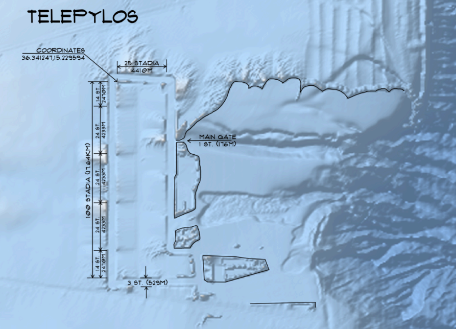
Fig 1 – Bathymetric shaded relief map. Dimensions shown are Metric and Ancient Greek (1 Stadia=176.4m).
The main gate—a narrow passage framed by sheer cliffs—leads into an inner harbor. A continuous row of cliffs defines the northern edge, while a headland juts southward, shaping a protective bay. Although there is much accumulation of sediment, using a simple process I call digital dredging, underwater landscapes were virtually reshaped by removing layers of soft, loose sediment from bathymetric data to reveal underlying structures or features. Using high-resolution heightmap data from EMODnet—a comprehensive resource for European marine bathymetry—I imported the raw depth measurements into Unreal Engine, a powerful tool for 3D visualization and terrain manipulation. Within Unreal Engine, I applied a targeted editing process, stripping away up to 50 meters of accumulated sediment in specific areas where soft, unconsolidated material typically gathers, in this case, the inner bay and perimeter canal. This digital excavation enhances the visibility of harder, potentially significant formations beneath, offering a clearer view of the seabed’s natural or artificial contours. The result is a refined, interactive 3D model that simulates what the bathymetry might look like after such sediment removal, blending scientific precision with creative exploration.
Though the current survey remains incomplete, several large, potentially intentional formations beg further exploration.One structure that is hard to ignore appears to be a central temple, positioned directly opposite the entrance to the main gate. A time may come where it is revealed to rival the Great Pyramid in scale. Standing over 150m above the ancient waterline, it must have been a sight to behold.
Another structure, also nearly 150 meters above the ancient sea shore, positioned at the headland’s tip, might be interpreted as a massive lighthouse. If further exploration confirms these possibilities, they could reveal a city designed with maritime precision and advanced planning, amplifying its historical weight.
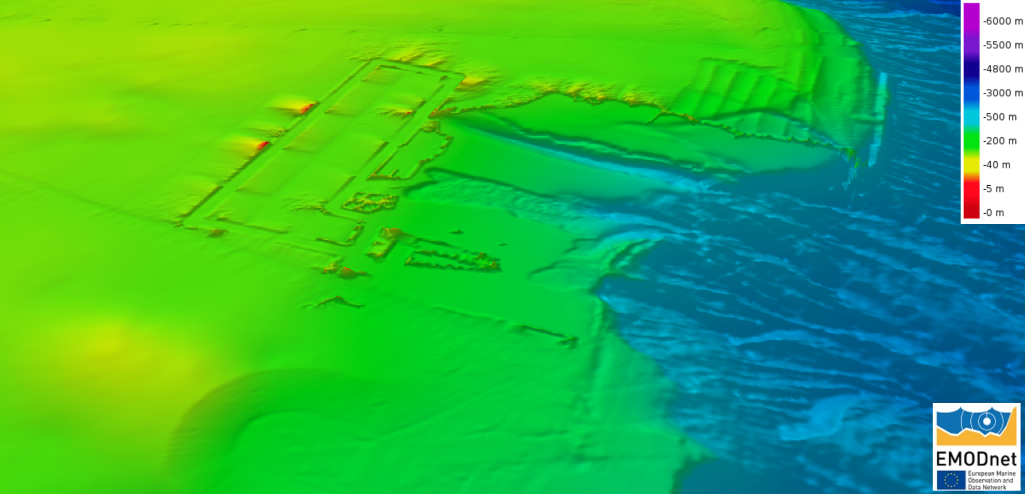
Fig 2 – Isometric 3d view of site using a Mean depth rainbow colour shaded relief map (https://emodnet.ec.europa.eu/)
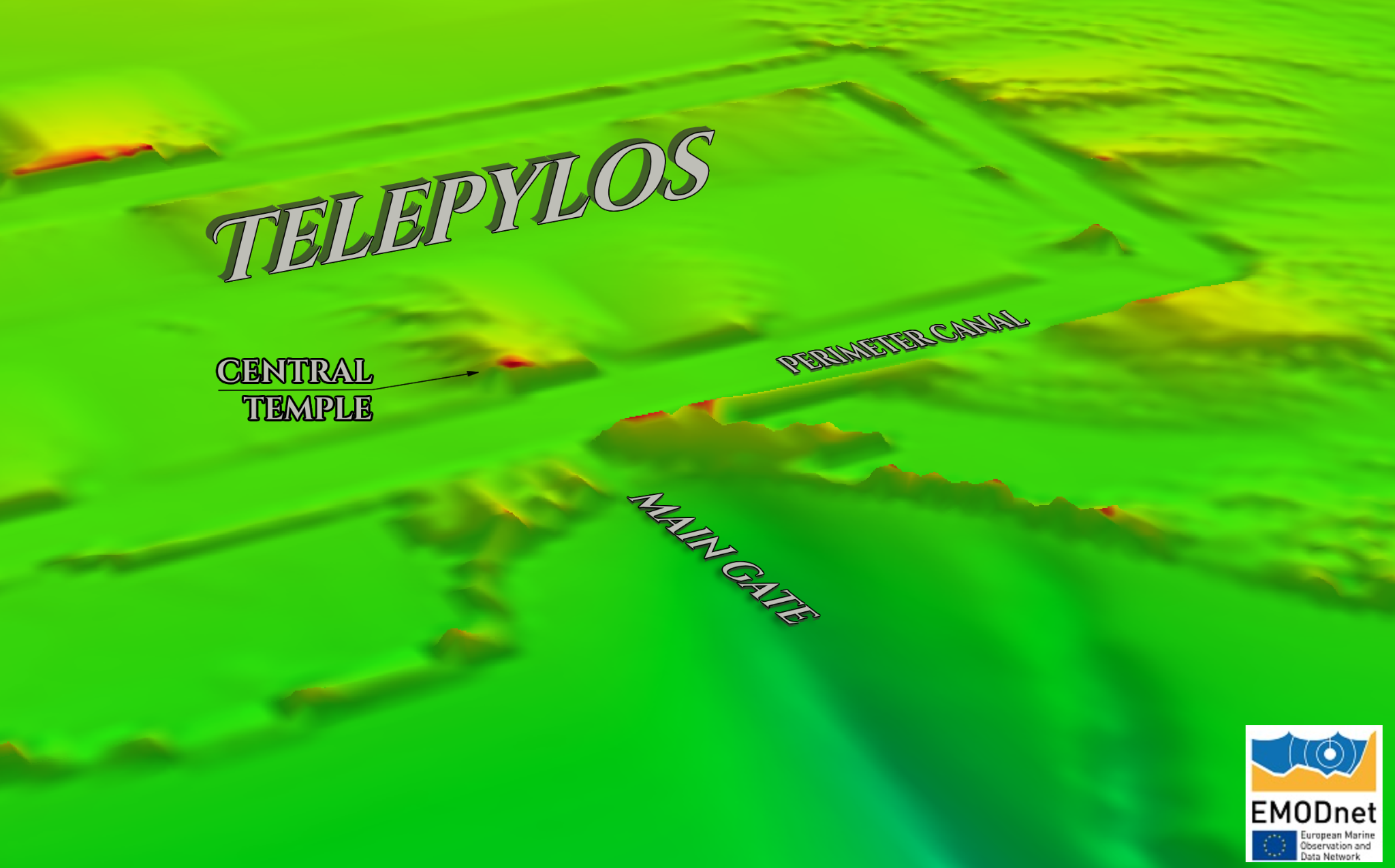
Fig 3 – Central temple, positioned directly opposite the entrance to the main gate. (https://emodnet.ec.europa.eu/)
Telepylos stands out not only for its discovery but for the enigmas it poses. How could such a sprawling settlement exist in this location, now lost beneath the sea? When did it meet its end, and what forces conspired to bury it in the Mediterranean’s depths?
Odysseus at Telepylos
The tale of Odysseus’ encounter with the Laestrygonians, as told in the Odyssey, blends terror with a hint of dark humor. He describes a harrowing ordeal—giant, flesh-eating inhabitants raining destruction on his fleet—but a closer reading suggests he may have stretched the truth, perhaps to save face or heighten the drama. His account demands careful scrutiny.
Odysseus, the wily hero, moors his ship at a rocky outcropping and sends two scouts and a herald ashore to meet the locals, keeping himself at a cautious distance. A young girl—notably not a giant—guides the men to her parents. Then, the story takes a grim turn: the Laestrygonians attack, allegedly devouring some of Odysseus’ crew, while the survivors flee to their ships, only to be bombarded by massive boulders from above, shattering the fleet. Odysseus, watching from his strategic perch, swiftly cuts the mooring line and orders his crew to row for their lives, abandoning the rest to their fate.
How does he know what happened ashore? No one survived to report back. From his distant vantage point, he could only piece together a narrative, likely shaped by fear, survival instinct, or the haze of memory. Giants might have been imposing statues, misread in panic. Hurling stones could point to early siege weapons—catapults or trebuchets—rather than superhuman strength. Cannibalism? Perhaps an embellishment to underscore the brutality of an unknown foe. Odysseus’ instincts secured his survival, but the details of his tale invite skepticism, refined over centuries by oral tradition and Homer’s dramatic flair.
Some might argue I’m shaping the story to match the site, but my intent is to place Homer’s words within their geographical context—to explore how the landscape itself might have inspired the narrative, not to force an interpretation.
From the Odyssey (paraphrased):
“When we arrived at the well-sheltered harbor, sheer cliffs flanked both sides. Along the north, a continuous wall of stone stretched unbroken. On the opposite side, a great headland jutted into the sea, enclosing the bay. The fleet sailed ahead through the narrow passage into a peaceful harbor, where ships lay in still waters. Sensing caution, I stayed back, mooring our black ship at a rocky outcropping near the entrance and climbed to a rugged height to scout the land. Initially, I saw no fields or farmland—only mountains and thick forests stretching far. Yet beyond the trees, faint spirals of smoke curled into the sky, suggesting life. Hoping for answers, I sent two men and a herald to seek the locals and learn what kind of people dwelt there. They rowed a small boat ashore, and from my perch, I watched them step onto a well-worn road along the forest’s edge—a smooth, deliberate path, not the wilds of an empty land, but a sign of human hands. It led away from the shore, vanishing into the dense trees, toward what I could only guess was the city beyond.”
Odysseus’ View: A Glimpse Through the Fog
How closely does the submerged site south-southeast of Portopalo align with Odysseus’ fleeting visit to Telepylos in Homer’s Odyssey? The connection is striking, yet tantalizingly incomplete—much like the hero’s own experience. Odysseus, ever the cautious navigator, never ventured deep into the heart of Telepylos. As he recounts, he noted the numerous ships moored within its sheltered harbor—a sight that likely signaled both opportunity and danger. Instead of pressing inland, he chose to anchor his black ship at a rocky outcrop along the northern edge of the bay, a decision shaped by his approach from the east. This vantage point, likely the eastern shore given his trajectory, offered safety and a clear view of the harbor’s entrance without committing his crew to the unknown depths beyond.
The landscape he describes matches the underwater terrain with uncanny precision. The “sheer wall of stone” stretching along the north corresponds to the towering cliffs that still define the site’s submerged profile, their imposing forms enduring despite 50 meters of sediment piled atop them over millennia of rising seas. This buildup, a slow burial rather than a sudden collapse, cloaks the city’s grandeur but leaves its skeletal outline intact. The main gate—a narrow passage flanked by cliffs—remains discernible, leading to the inner harbor just as Homer depicted. Nearby, the headland jutting southward into the bay mirrors the “great headland” of the tale, enclosing the waters in a protective embrace. These features anchor Odysseus’ words to a real place, suggesting his account wasn’t mere fancy but a distorted reflection of an ancient reality.
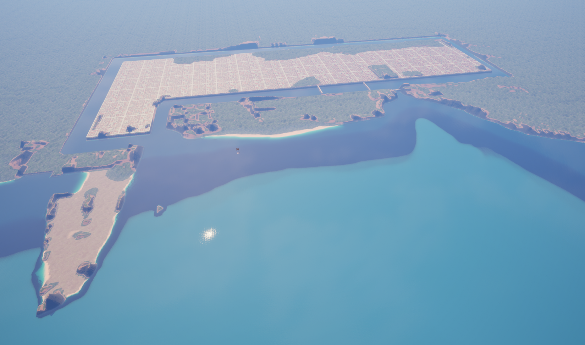
Fig 4 – Visualization of Telepylos circa 9,600 BC.
Yet what Odysseus saw—and what Homer preserved—is only a sliver of Telepylos’ story. Unlike Plato’s vivid, almost encyclopedic portrait of Atlantis, drawn from a wellspring of detailed tradition, Homer offers a fragmented glimpse, filtered through Odysseus’ narrow lens. The hero’s perspective was inherently limited—he stayed at the periphery, peering into a world he never fully grasped. Had his scouts and herald survived their ill-fated meeting with the Laestrygonians, the Odyssey might never have emerged as we know it, leaving us with even less to decipher. Instead, we inherit a visceral, savage impression: a city of chaos and barbarity, its inhabitants hurling boulders, its harbor a trap. This portrayal masks the true scale and sophistication hinted at by the site’s engineered canals and structured layout—a grandeur Odysseus couldn’t fathom from his distant perch.
Had Homer known the city’s vastness—its 17.64-by-4.41-kilometer expanse, its half-kilometer-wide canal—he might have crafted a tale of awe rather than terror, celebrating Telepylos as a marvel of human endeavor. Odysseus’ restricted view makes sense in this light; he never breached the harbor’s edge or traced the roads winding inland. His survival hinged on that caution, but it left him blind to the city’s deeper truths. By contrast, Plato’s Atlantis sprang from a richer, more intimate source—perhaps a priestly record or a cultural memory passed down with care. If Odysseus had sailed to Atlantis instead, his account would likely remain just as superficial, confined to fleeting impressions from afar, unable to capture the intricate rings and towering temples Plato describes.
This disparity underscores Telepylos’ enigma. Odysseus’ tale is a shadow on the cave wall—vivid, gripping, yet incomplete. The submerged site fills in the gaps, bridging myth and reality with its silent stones. It invites us to see beyond the hero’s fog, to imagine a Telepylos not of giants and ruin, but of ingenuity and ambition, lost to time yet waiting to be reclaimed.
Telepylos: A Submerged Legacy
How does a city “sink” beneath the waves? The city never sank as much as it succumbed to the rising waters. There are countless myths regarding flooding events in the Mediterranean, and this gives them proper context.
During the last Ice Age, the Mediterranean was cut off from the Atlantic as global sea levels plummeted. Its waters receded further, unveiling vast stretches of fertile plains where civilizations took root and flourished. As glaciers melted, the sea slowly reclaimed these lands—not through a sudden catastrophe, but in a steady transformation stretching across millennia. Even the Mediterranean’s gentle microclimate couldn’t stem this inexorable rise. Periodic surges of peak flooding left their mark on our ancient memory, yet they linger like a fading dream, easily swept away by the dawn of a new era.
The Zanclean megaflood hypothesis suggests that 5.33 million years ago, after the Messinian Salinity Crisis, the basin refilled in a dramatic surge as Atlantic waters breached Gibraltar within a few years—one of Earth’s most striking geological shifts. But I propose an alternative timeline.
The Bolonia–Tangiers Land Bridge Hypothesis
It is commonly accepted that during the Ice Age, global sea levels dropped approximately 125m below current levels. Prior to the Ice Age, the Mediterranean was like it is today generally, but as the sea level dropped, a land bridge was exposed and cut off the Mediterranean from the Atlantic.
Sea levels may have fallen as much as 250 meters—double the widely accepted 125-meter drop. Cut off from the Atlantic, the basin became a closed system, with evaporation outpacing inflow from rivers and rain, exposing broad coastlines ripe for settlement.
The Strait of Gibraltar’s inflow governs Mediterranean water levels. If blocked, the basin would settle into a lower equilibrium as levels dropped. Bathymetric maps hint at an ancient land bridge linking southern Spain (near Bolonia) to northern Morocco (near Tangiers). At the -275m depth contour, a continuous shoreline emerges, suggesting a connection that may have risen to -60m, isolating the Mediterranean for up to 80,000 years.
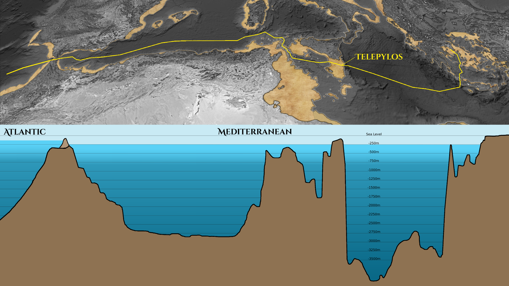
Fig. 5 – Plan and Profile of the Mediterranean during the Last Glacial Maximum.
While global seas fell by about 125 meters, the Mediterranean plunged to 250 meters below current levels, reaching stability for possibly 80,000 years. This extended window allowed civilizations to establish, flourish, and innovate. The exposed plains, fertile and tempered by a predictable climate, became cultural and economic hubs. Telepylos stands as a monument to this era—its construction spanning generations, a feat defying the simplicity often ascribed to prehistory. Likely abandoned by 8,600 BC, its origins stretch far earlier, perhaps thriving for millennia before the sea overtook it. Its timeline intriguingly overlaps with Atlantis, another lost maritime titan.
Though parallels between Telepylos and Atlantis remain speculative, both are depicted as thriving ports along vital trade routes, surrounded by rich lands. Telepylos, with its monumental scale and intricate design, offers a tantalizing glimpse into the potential of ancient societies, urging us to rethink what was possible in the distant past. Could it be the key to merging myth with history? Its questions—of origin, fate, and ties to other legendary cities—beckon us to probe deeper into the Mediterranean’s submerged secrets.
Telepylos in Context: The Mediterranean’s Hidden Network
Telepylos’ story extends beyond its walls—its existence hints at a broader, hidden Mediterranean world. If the Bolonia–Tangiers Land Bridge Hypothesis holds true, the Mediterranean basin during the Last Glacial Maximum was not the sea we know today. Its shores stretched far beyond their current bounds, its plains bloomed with life, and its waters were hemmed in by a natural barrier that severed it from the Atlantic. This wasn’t a desolate void but a vibrant crossroads, potentially teeming with early human societies. Telepylos, with its vast harbor and engineered defenses, was likely no solitary marvel but a key node in a now-submerged network of settlements.
Archaeological parallels paint a broader picture. In southeastern Turkey, Göbekli Tepe—dated to around 9,600 BC—stands as proof that monumental architecture thrived in an era once deemed too primitive for such feats. Its carved pillars and enclosures mirror the ambition seen in Telepylos’ canal and cliffs. Elsewhere, submerged sites like Japan’s Yonaguni Monument or France’s Cosquer Cave—flooded as seas rose—suggest a recurring theme: coastal cultures flourishing during the Ice Age, only to be erased by the same unstoppable tides that claimed Telepylos. These parallels frame it as a maritime hub, possibly a linchpin in a chain of settlements that dotted the basin’s expanded shores.
Bathymetric data deepens this vision. The -250m contour along the Malta-Sicily Escarpment reveals a sprawling shelf—hundreds of kilometers of once-habitable land that could have sustained a constellation of communities. If the land bridge held for 80,000 years, as proposed, this prolonged stability would have nurtured a thriving prehistoric world. Farmers likely tilled the fertile plains, their crops feeding growing populations. Sailors navigated the reduced sea, their vessels threading between ports like Telepylos, guided perhaps by that potential lighthouse at the headland’s tip. The canal, a half-kilometer wide, speaks of wealth and power worth defending—whether from rival groups or the sea itself.
This network’s scale is staggering yet plausible. Telepylos’ precise layout and monumental features suggest it was built to endure, a testament to a society that mastered its environment. Its fate, though, was shared by its unseen neighbors. As the Ice Age waned and the land bridge gave way, rising waters didn’t just swallow one city—they drowned an entire cultural landscape. Telepylos endures as a rare, detectable relic, its submerged ruins a window into this lost era. It hints at a Mediterranean not of scattered outposts but of interwoven societies—a tapestry of human endeavor now hidden beneath the waves, awaiting rediscovery through modern exploration.
Correcting the Timeline
In Greek mythic tradition, Plato’s Timaeus and Critias place Atlantis’ fall 9,000 years before Solon (ca. 600 BCE), while Odysseus and Heracles roam the Late Bronze Age (13th–12th century BCE). But what if this chronology is misaligned? Telepylos, built at -250m, could only have thrived during a prolonged era of shoreline stability. As Earth warmed post-Ice Age, global seas rose from -125m. When the Atlantic breached the land bridge at -60m—its precise timing uncertain—that stability crumbled, and the sea swallowed coastal worlds. This suggests Telepylos was uninhabited until 8,600 BCE, with roots stretching thousands of years earlier.
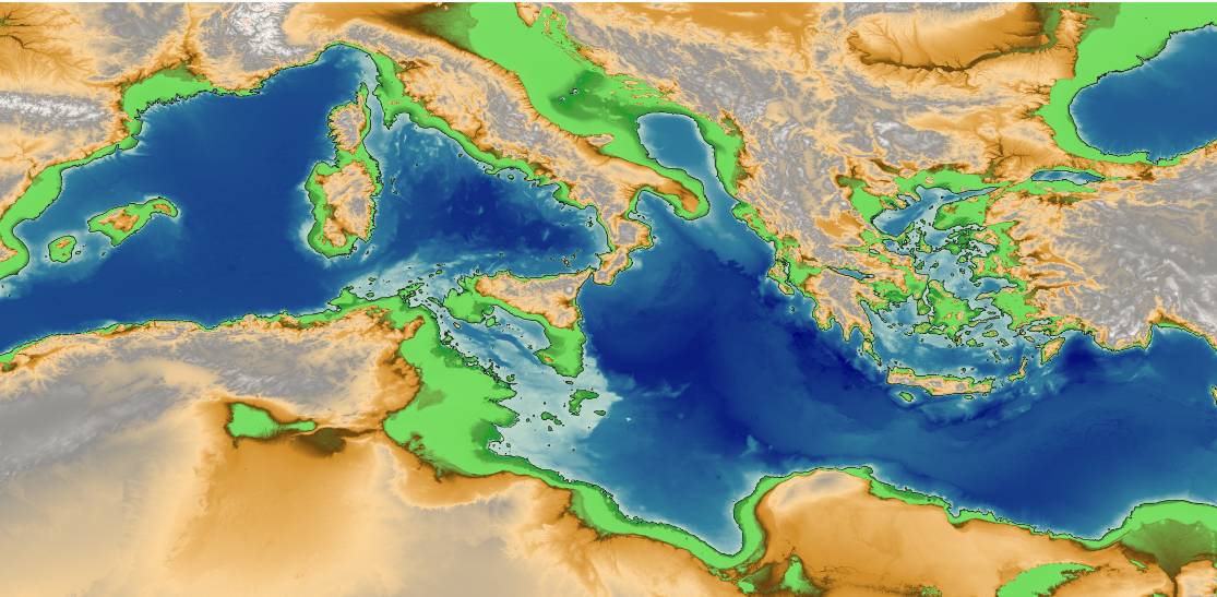
Fig. 6 – Bathymetric map showing the Mediterranean basin at 250 meters below current sea levels, illustrating hypothesized exposed landmasses during the Wisconsinan glacial period. Credit: Data from EMODnet Bathymetry Database (www.emodnet-bathymetry.eu)
If Telepylos predates the Bronze Age by millennia, the Odyssey and Iliad may reflect a far older world—one where the Mediterranean’s shores stretched vastly different. This implies Odysseus, and the myths tied to him, have been misplaced in time, echoing a distant era lost to rising tides. It’s a seismic shift in perspective, suggesting countless “mythical” cities and peoples lie submerged, waiting to be found.
By revisiting Homer’s Odyssey through this lens and cross-referencing modern geospatial data (like EMODnet and GEBCO), we can re-evaluate countless mythological tales, mapping their ancient narratives onto tangible landscapes and uncovering new insights into how these stories reflect humanity’s evolving relationship with the physical world.
This claim challenges orthodoxy, and I’m no master of classics—nor is anyone, truly. Our knowledge rests on fragile assumptions, gaps in evidence, and unchallenged narratives. The scale of this discovery staggers even me. Yet history evolves with each breakthrough— heliocentrism, evolution, quantum physics—all once unthinkable. If Telepylos demands a rewrite, we must heed the call, however daunting.
A New Dawn for the Ancient World
For centuries, we’ve cast humanity’s oldest myths as mere stories—tales to amuse or explain the unknown. But what if they’re rooted in reality? Telepylos stands as tangible proof that entire chapters of our past, once labeled “myth,” lie dormant beneath the waves.
The next step is clear: Telepylos needs exploration. Plans for a full underwater survey with ROVs and submersibles are underway, though funding remains uncertain. This isn’t just a pursuit of knowledge—it’s a challenge to historical norms. Telepylos’ scale, its link to the Odyssey, and its breathtaking mystery hold the makings of an archaeological revolution—ripe for books, documentaries, films, even interactive games. Imagine strolling its harbors in VR or watching its rise and fall on screen. With Nolan set to adapt The Odyssey, I’d love to share this find’s potential to reshape that epic.
Beyond lies Atlantis. I’m growing certain of its location, possibly sharing a shoreline with Telepylos, yet it had a much different fate. Proving one city’s existence strengthens the case for another. Telepylos is the gateway—the first step to rewriting our past and reclaiming truths long submerged. We can cling to a world where myths stay myths, or embrace a dawn where the ancient world is rediscovered. In archaeology, one truth endures: the deeper you dig, the older the story gets.
Primary Sources & Research Papers
- Garcia-Castellanos, D., Estrada, F., Jiménez-Munt, I., Gorini, C., Fernàndez, M., Vergés, J., & De Vicente, R. (2009). Catastrophic flood of the Mediterranean after the Messinian salinity crisis. Nature, 462(7274), 778–781. doi:10.1038/nature08555
- Lamb, H. H. (1995). Climate, History and the Modern World. Routledge.
- Micallef, A., Camerlenghi, A., Georgiopoulou, A., Garcia-Castellanos, D., & Gutscher, M.-A. (2018). The Malta-Sicily Escarpment: Mass Movement Dynamics in a Sediment-Undersupplied Margin. Tectonophysics, 744, 315-332. doi:10.1016/j.tecto.2018.07.017
- Parker, A., & Ollier, C. D. (2016). The Zanclean Flood and Open-Channel Hydraulics: The Role of Gibraltar in Mediterranean Sea-Level Change. Quaternary International, 408(1), 22–34. doi:10.1016/j.quaint.2016.01.034
- Postglacial Sea Level Rise in the Mediterranean and its Impact on Coastal Settlements. (2015). Journal of Quaternary Science, 30(3), 233–246.
Historical & Archaeological References
- Homer. The Odyssey. Trans. Richmond Lattimore. University of Chicago Press, 1965.
- Plato. Timaeus & Critias. Trans. Benjamin Jowett. Clarendon Press, 1871.
- Strabo. Geographica. Trans. Horace Leonard Jones. Harvard University Press, 1923.
- Thucydides. History of the Peloponnesian War. Trans. Rex Warner. Penguin Classics, 1954.
Geological & Environmental Studies
- Stanley, D. J., & Warne, A. G. (1994). Worldwide Initiation of Holocene Transgression and its Effects on Mediterranean Coastal Sites. Science, 265(5173), 998–1007. doi:10.1126/science.265.5173.998
- Flemming, N. C. (1978). Holocene Eustatic Changes and Coastal Archaeology in the Mediterranean Region. Nature, 271, 315–317.
- Shackleton, N. J. (1987). Oxygen Isotopes, Ice Volume, and Sea Level. Quaternary Science Reviews, 6(3-4), 183-190.
Note from the Author:
While my work explains how I arrived at identifying Telepylos, I later discovered that Luigi Usai had already observed an underwater anomaly off the coast of Sicily, suggesting a submerged city in 2021 that he documented in several papers and his book, Riscriviamo La Storia, published in Italian in 2022.
I’m grateful he brought attention to that area. While my own approach to this topic has developed independently, I welcome any insights that deepen our collective understanding of these underwater structures. Acknowledging and learning from prior efforts is an essential part of the scientific process. As mentioned, Telepylos is only one piece of a much larger lost world, essentially a gateway to an even greater mystery that deserves deeper investigation.
Thanks Andre for the excellent and enlightening article. I had not heard of this site before.
Not many have. The site was surveyed in 2012, and when I spoke to the Marine Geologist, Dr. Aaron Micallef about the survey, he said they didnt recognize it for what it was.
Really strange: because to me, Aaron Micallef wrote this:
Dear Luigi,
Many thanks for your email.
I am afraid the features you refer to are not anthropogenic. They result from the varying resolution of the data acquired during different seafloor surveys. The long rectangular shapes indicate areas with higher spatial resolution from data I collected in 2012.
I apologize if this is not the response you were expecting.
Best wishes,
Aaron
Aaron Micallef
a: Luigi Usai
data: 21 lug 2024, 01:17
oggetto: Re: Online Directory: New discoveries about the Sicily-Malta Geology and Seafloor Surveying
proveniente da: um.edu.mt
firmato da: um-edu-mt.20230601.gappssmtp.com
sicurezza: Crittografia standard (TLS) Scopri di più
I spoke with Dr. Micaleff via Zoom about this, and although my new evidence seemed to resonate with him, I certainly don’t speak on his behalf.
This is excellent, thank you for sharing!
Thanks for sharing your research and perspective. We know very little about our ancient history. People like you and Graham are vital to discovering the truth.
And thank you for your comment. I am an unknown in this field, just a citizen scientist trying to do their part.
Before you read the following quotes, note that if the received dates are mistranslated or misreported by about an order of magnitude, then the Atlantis war coincides with the invasion of the Sea Peoples. This is actually a necessary assumption in order to make Atlantis and Athens coexist, anyway… Also note the Greek word for “island” was also the word for “peninsula”…
Here is an excerpt from Plato’s Timaeus, written ~2400 years ago:
“Many great and wonderful deeds are recorded of your state in our histories. But one of them exceeds all the rest in greatness and valour. For these histories tell of a mighty power which unprovoked made an expedition against the whole of Europe and Asia, and to which your city (Athens) put an end. This power came forth out of the Atlantic Ocean, for in those days the Atlantic was navigable; and there was an island (peninsula) situated in front of the straits which are by you called the Pillars of Heracles; the island (peninsula) was larger (“greater”, not necessarily bigger in physical size) than Libya and Asia put together, and was the way to other islands, and from these you might pass to the whole of the opposite continent which surrounded the true ocean; for this sea which is within the Straits of Heracles is only a harbour, having a narrow entrance, but that other is a real sea, and the surrounding land may be most truly called a boundless continent.”
Now, Plato’s Critias:
“And [Poseidon] named them all; the eldest, who was the first king, he named Atlas, and after him the whole island (peninsula) and the ocean were called Atlantic. To his twin brother, who was born after him, and obtained as his lot the extremity of the island towards the pillars of Heracles (Morocco), facing the country which is now called the region of Gades (Cadiz, Spain) in that part of the world, he gave the name which in the Hellenic language is Eumelus, in the language of the country which is named after him, Gadeirus.”
Finally, read The Histories of Herodotus:
“I have now described all the nomadic Libyans who live on the coast. Farther inland than these is that Libyan country which is haunted by wild beasts, and beyond this wild beasts’ haunt runs a ridge of sand that stretches from Thebes of Egypt to the Pillars of Heracles.60
…After another ten days’ journey there is again a hill of salt, and water, and men living there. Near to this salt is a mountain called Atlas, whose shape is slender and conical; and it is said to be so high that its heights cannot be seen, for clouds are always on them winter and summer. The people of the country call it the pillar of heaven. [4] These men get their name, which is Atlantes, from this mountain. It is said that they eat no living creature, and see no dreams in their sleep. 185.
I know and can tell the names of all the peoples that live on the ridge as far as the Atlantes, but no farther than that. But I know this, that the ridge reaches as far as the Pillars of Heracles and beyond them.”
I’m not going to copy/paste every single quote, but a correct translation seems to reveal that Atlantis was a “mighty peninsula” NOT a “large island”. Here are a few other points worthy of noticing: Greek and Egyptian historians believed Libya/Africa to be much smaller, because they sailed around it multiple times, somehow. The Indus Valley civilization were identified as Eastern Ethiopians. Finally, don’t miss the fact that ancient Greeks knew of some “opposite continent” “surrounding” a navigable Atlantic Ocean…
Atlantis was island, and I found it before Telepylos.
The only issue is, its much harder to prove.
False, Atlantis was not an island and you did not find it. Not every lost city is Atlantis. There are many other lost cities, and I’m interested to see whatever you think you found, if you ever stop playing games and release the information. Regardless, it is not Atlantis. The description of Atlantis is 100% explicit and clear in the quoted passages of Plato and Herodotus. Atlantis is Northwest Africa. Mauritania/Morocco, with the capitol city at Richat.
I’m really interested: please, could you tell me where I can find your research about Atlantis?
I’m very curious: if you are interested, I can analize it and tell you if I do find potential errors/mistakes.
My research show that Atlantis should be the Sardinian Corsican geological block; may I ask you please where did you find Atlantis? I’m really curious about it.
If you accept new informations about new discoveries, when I found the Sicily Malta Platform – Sicily Malta Escarpment bathymetric anomalies, I found many more: that one was just one of many anomalies.
I found more in Birsa Bank, on the Sardinian Corsican Paleoshores, and many more.
I published most of my discoveries on my website http://www.atlantisfound.it, give me the time to check some correct link:
Birsa Bank strange artifacts:
https://www.atlantisfound.it/2022/01/16/luigi-usais-birsa-bank-civilisation/
https://www.atlantisfound.it/2022/01/01/luigi-usai-discovery-on-submerged-mediterranean-banks/
New bathymetric anomalies on the Sicily Channel:
https://www.atlantisfound.it/2025/04/01/nuove-potenziali-scoperte-altre-anomalie-batimetriche-nel-canale-di-sicilia-d/
As far as the city name I found on the Sicily Malta Platform, her name is Su Mei Lin, written in Mandarin Chinese like this: 苏美邻。
I gave the city the name of my chinese friend from Shenzhen, China.
Of course, I do understand why you call it Telepylos, I found it really interesting, I didn’t ask any LLM to suggest me a plausible name, I just gave the fist name I thought 😀
There’s something else I don’t understand. When I did this discovery of bathymetric anomalies, I did hundreds of screenshots, which I published everywhere. I don’t understand: why did you just publish 2 Cropped photos and a VR seabed reconstruction? Why not to publish tons of more images, to show to the public what I found?
In my website, http://www.atlantisfound.it, I’m publishing high definition images with the best resolution possible with Emodnet Bathymetry.
I think you’ll find something useful for your research.
Best regards
Luigi, Quartucciu, Italy
https://www.google.com/search?q=%E8%8B%8F%E7%BE%8E%E9%82%BB+Usai&newwindow=1&sca_esv=fb769e0fcd5d8652&rlz=1C1CHBF_itIT1151IT1151&udm=2&biw=1536&bih=730&ei=XWf1Z8_CC9KAi-gPrfjP8QM&ved=0ahUKEwiP5daDhcmMAxVSwAIHHS38Mz4Q4dUDCBE&uact=5&oq=%E8%8B%8F%E7%BE%8E%E9%82%BB+Usai&gs_lp=EgNpbWciDuiLj-e-jumCuyBVc2FpSPEQUKMJWMYOcAF4AJABAJgBgwGgAeUEqgEDMC41uAEDyAEA-AEBmAIAoAIAmAMAiAYBkgcAoAf_AbIHALgHAA&sclient=img
Awesome information very believable
Brilliant, fascinating and enthralling. Thank you. It is so satisfying to observe falsification in action, to watch assumptions elevated by decreed conditioning gradually implode into their own dust. It also hints how readily and perhaps even eagerly humanity is coerced and controlled by conditioning that more often or not appears so distantly removed from beneficence.
André thanks for this ver interesting article. I do have one question on the method used and it is just curiosity not mend as criticism. When applying the process of sediment removal, did you use any presumption on the underlying structure or did the structure emerge out of nothing? Or asked differently, when you take an arbitrary piece of ocean floor and apply the same method, would nothing show up? I am just curious as this seems an enormous powerfull tool to investigate coastlines.
Also to how many meters of sediment would this scale and how is the error in the result dependent on the amount of sediment?
It was derived from the paper cited…Micallef, A., Camerlenghi, A., Georgiopoulou, A., Garcia-Castellanos, D., & Gutscher, M.-A. (2018). The Malta-Sicily Escarpment: Mass Movement Dynamics in a Sediment-Undersupplied Margin.
There was 50m of loose silt and sand built up around the entrance, so 50m was removed from the heightmap in areas adjacent to hard edges, or cliffs. The perimeter canal would not be visible today if initially it wasnt so deep.
I’m really sorry but these are glitches from how the software stitches multiple data sources together. If you turn on the ‘Source Reference of the DTM’ option in the EMODnet Bathymetry viewer you can clearly see the reference data that causes the glitch. You see these software artefacts all over the world, as the dataset for EMODnet viewer improves these glitches often disappear.
Im sorry but you are incorrect.
I have looked at the source you refer to but that changes nothing. I have extensive experience with bathymetric imaging and ‘stitching’ and this is not the case.
The site measures precisely to the ancient Stadia, which immediately nullifies any ‘glitch’ argument.
I’m guessing, but this is far too deep to send a person down to have a look, but is there not photographic equipment than can be used?
You are correct that it is too deep for recreational diving, however its at a depth that could be reached through saturation diving.
Yes. I’m a bit surprised that given the current interest in deep-sea mining, and the endless goes at the Titanic, that there isn’t unmanned equipment available to get down and take a look. There must be massess of stuff to be found, as GH noted in his ‘Underwater’ 20 odd years ago.
Dear Andre, my name is Giorgio Aprile, you are confirming what I had also hypothesized, as you will read in the report I can send you. I am a geologist who lives in those places, in Ispica, and I would love to collaborate with you on a possible research campaign. I can provide useful logistical support also based on my knowledge of the territory and its human and material resources. You can contact me on Facebook or by email
Dr. Luigi Usai already discovered this structures and they are published since December 2021 on Google searching the words
Sicily Malta Escarpment. You should give him credit, if you are using the scientific method.
https://www.atlantisfound.it/2025/03/30/sicily-malta-platform-escarpment-emodnet-bathymetry-by-luigi-usai/
Best regards
Thank you for bringing Dr. Usai’s work to my attention. I wasn’t aware of his specific findings on the Sicily–Malta Escarpment, and I appreciate the opportunity to learn more about his research. My own approach to this topic developed independently, but I welcome any insights that deepen our collective understanding of these underwater structures. Acknowledging and learning from prior efforts is an essential part of the scientific process, so I’m grateful you mentioned his name and will make sure to give credit where it’s due.
This discovery’s been published online 4 years ago by Dr. Luigi Usai… on Amazon you can even find a book with this submerged city:
https://www.amazon.it/Riscriviamo-Storia-Incredibile-sottomarina-Mediterraneo/dp/B09Q8WN1KK/ref=sr_1_15?dib=eyJ2IjoiMSJ9.GhdYhmJCIPfrrldMyiYC8z9PsVttnZch4zTijAh79282yA89ANZ8j66DyFWVZMPaUOy3lIm5NQ2QaXTY2E0A0loaNQpMfWU4TW5ryF9FfkXWFqFeiXRQyt6uhVPhthab4bAGQ_Hol3tYujF0KfB0Y0xSbioL-4ZpqwFPyA7vXF817riIdFNWDrtQ5xviWJx2O6WclxyVJfvUftSEu5mRXNRpfd7ZRJ2Bswkqxe9W0lM.GOWKv49fLK1Bz98DJJivIU2VAtvwJ5uCm2i69gz3f7s&dib_tag=se&qid=1743508398&refinements=p_27%3A%22Luigi+Usai%22&s=books&sr=1-15
Thank you for bringing Dr. Usai’s work to my attention. I wasn’t aware of his specific findings on the Sicily–Malta Escarpment, and I appreciate the opportunity to learn more about his research. My own approach to this topic developed independently, but I welcome any insights that deepen our collective understanding of these underwater structures. Acknowledging and learning from prior efforts is an essential part of the scientific process, so I’m grateful you mentioned his name and will make sure to give credit where it’s due.
Subject: Clarification on the Discovery of the Submerged City near the Sicily-Malta Escarpment
Dear Mr. Chaisson,
I hope this message finds you well. I am writing to provide some important clarifications regarding the discovery of the submerged city located near the Sicily-Malta Escarpment. It appears there has been some confusion about the attribution of this discovery, and I would like to respectfully address the issue and clarify the true circumstances surrounding it.
The first official discovery of the submerged structures in this region was made by Dr. Luigi Usai, a researcher from Quartucciu, Sardinia. Dr. Usai published his findings in December 2021, revealing detailed bathymetric images of the submerged city. His work was documented with precise coordinates, photographs, and data, and was promptly shared with various authorities, including the Italian Ministry of Culture and the Superintendency of the Sea.
Dr. Usai’s discovery has been publicly acknowledged and verified by numerous credible sources. One of the key sources for this confirmation is Atlantipedia, a well-known platform dedicated to the study of ancient submerged civilizations. The authors of Atlantipedia were themselves witnesses to Dr. Usai’s work and can attest that he was the first to uncover these underwater structures. In fact, Atlantipedia published articles and shared detailed discussions regarding Dr. Usai’s findings as early as 2021, establishing him as the primary discoverer of these underwater anomalies. You can find more information on their website here: Atlantipedia – Luigi Usai’s Discovery: https://atlantipedia.ie/samples/tag/luigi-usai/
It is essential to note that although other researchers, including yourself, have independently studied similar bathymetric images, the original discovery and analysis were conducted by Dr. Usai. As a result, the scientific community and the public should credit Dr. Usai for his pioneering work on this subject. Dr. Usai’s findings have been documented in his book “Riscriviamo la Storia: l’incredibile città sottomarina nel Mediterraneo”, which further outlines his extensive research and conclusions about the submerged city.
It is understandable that researchers may independently come across similar data, but it is crucial in scientific discourse to recognize and respect the contributions of earlier discoveries. Acknowledging Dr. Usai’s role as the first to discover and publish these findings not only ensures academic integrity but also upholds the value of prior research.
In light of these facts, I kindly request that you and your team update any references to the discovery of the Sicily-Malta submerged city to accurately reflect Dr. Usai’s original role in this groundbreaking work. This will help maintain the integrity of scientific reporting and provide proper recognition to Dr. Usai for his contributions to this fascinating field of study.
Thank you for your understanding, and I look forward to your response.
Best regards,
Simonetta Pinna
What important about this discovery is not the city itself, but what it implies.
Telepylos is a gateway to a much broader understanding of the mediterranean over the last 100,000 years. If Dr. Usai, and indeed the broader scienticific communnity was aware of this site then they missed the true revelation and the implications.
He can have all the credit for seeing it first, frankly I expected someone had to have seen it before me but in truth he did not really know what he was looking at, and its importance in uncovering our lost past.
Sicily Malta platform and Sicily Malta Escarpment Discovery by Dr Luigi Usai in December 2021
https://www.atlantisfound.it/2022/01/13/scarpata-continentale-sicilia-malta-le-civilta-nascoste-e-perdute/
La notizia era già stata pubblicata e ufficializzata da altre testate giornalistiche online molti anni prima.
https://www.comunicatostampa.org/86597350/misteriosa-civilta-sommersa-ritrovata-al-largo-delle-coste-siciliane/
Official Discovery of Atlantis by Dr. Luigi Usai, Quartucciu, Sardinia
https://dataverse.harvard.edu/dataset.xhtml?persistentId=doi:10.7910/DVN/OYEIHZ
https://www.atlantisfound.it/2022/01/13/scarpata-continentale-sicilia-malta-le-civilta-nascoste-e-perdute/
La notizia è stata pubblicata per 4 anni consecutivi in centinaia di siti web, testate giornalistiche e video di YouTube
https://www.atlantisfound.it/2021/12/29/amazing-discovery-of-a-submerged-civilization/
The Discovery published on YouTube
https://youtu.be/22V3cKQkDzc?si=UvOGbMUhtKJDLvi2
Scientific method means to share information and telling the Truth.
Thank you in Advance for your contribution to History
Official Discovery of Atlantis by Dr Luigi Usai published on Mendeley
https://data.mendeley.com/datasets/cxkbdkrp6y/1
Luigi Usai even published a song about his discovery of a new sunken city on the Sicily Malta Platform / Sicily Malta Escarpment… hahaha so funny!
https://suno.com/song/cb7fe23e-191c-4d86-995d-ce681a19bce7
Subject: Cordial but Firm Request for Correction Regarding the Submerged City off the Coast of Sicily
Dear Mr. André Chaisson,
I am writing to you as Dr. Luigi Usai to express my disappointment regarding your recent article published on grahamhancock.com, concerning the submerged city off the coast of Sicily.
As someone currently pursuing a Master’s degree in Journalism here in Cagliari, Italy, I fully understand the dynamics of your profession and recognize that errors can occasionally occur in the process of research and publication. However, in the case of your article, I believe a significant oversight has caused considerable damage to my reputation as a researcher and scholar, especially considering my extensive academic background and dedication to this field.
As you are well aware, a fundamental principle of journalism is accuracy and the verification of sources. Unfortunately, your article does not acknowledge my work in discovering and documenting the submerged city off the coast of Sicily, which dates back to December 2021. Instead, the discovery is attributed to another individual who subsequently presented material potentially of lesser quality compared to the detailed images I initially published.
I understand that misunderstandings or a lack of complete information may have occurred. However, this omission and misattribution negatively impact my scientific reputation and the credibility of my research.
Therefore, I am writing to you cordially but firmly to request a public correction of your article. It is crucial to me that my prior discovery is acknowledged, with my name and the timeframe of my initial publications being clearly stated.
My discovery has even been published on Harvard University’s Dataverse: https://dataverse.harvard.edu/dataverse/harvard?q=Usai%20Luigi
For your reference and to facilitate the necessary correction, I would like to provide you with the scientific sources that clearly establish my priority in this discovery:
Source 1: Mysterious submerged artifacts on the Hyblean carbonate platform, west of Sicily-Malta Escarpment found by Luigi Usai
By luigiusai
Dec 29, 2021
https://www.atlantisfound.it/2021/12/29/amazing-discovery-of-a-submerged-civilization/
Source 2: Atene del 9600 a.C.? – piattaforma continentale carbonatica iblea Sicilia-Malta (Athens of 9600 BC? – Hyblean carbonate continental platform Sicily-Malta)
By luigiusai
Jan 13, 2022
https://www.atlantisfound.it/2022/01/13/scarpata-continentale-sicilia-malta-le-civilta-nascoste-e-perdute/
Source 3: Sicily Malta Plateau Platform and Sicily Malta Escarpment
By luigiusai
Jul 1, 2024
https://www.atlantisfound.it/2024/07/01/sicily-malta-platform-and-sicily-malta-escarpment/
Source 4: Harvard Dataverse
https://dataverse.harvard.edu/dataverse/harvard?q=Usai%20Luigi
Source 5: Mendeley repository: Official discovery of the legendary island of Atlantis
Published: 2 October 2024
DOI: 10.17632/cxkbdkrp6y.2
Contributor: Luigi Usai
https://data.mendeley.com/datasets/cxkbdkrp6y/2
Source 6: Atlantipedia website, well-known among Atlantis researchers worldwide:
https://atlantipedia.ie/samples/tag/luigi-usai/
Source 7: By searching on Google for the terms “Sicily Malta Platform” and “Sicily Malta Escarpment,” separately or together, and clicking on images, for over four years now, images from my websites dealing with the scientific discovery of bathymetric anomalies on the seabed of the Sicily Malta platform have been presented.
https://www.google.com/search?newwindow=1&sca_esv=lpd&hl=en&q=Sicily+Malta+Platform&tbm=isch&source=lnms&sa=X&ved=2ahUKEwi7_Y-w_q6FAxW-R_EDHYJgD8QQ0pQJegQIDBAB&biw=1536&bih=714&dpr=2.5#imgrc=a-specific-image-link-would-be-needed-here (Note: A specific image link would be needed here to be truly effective.)
Source 8: Teoria della Riva Würmiana
https://www.atlantisfound.it/2023/03/07/teoria-della-riva-wurmiana/
Source 9: I published songs about this particular discovery:
https://suno.com/song/cb7fe23e-191c-4d86-995d-ce681a19bce7
Source 10: Widespread Awareness and Formal Notifications in Italy: For the past four years, my findings have garnered significant attention within Italy, with hundreds of thousands of individuals having already viewed the images and information I have published online. Furthermore, to ensure official awareness and proper documentation, I sent formal registered emails (PEC – Posta Elettronica Certificata) approximately four years ago to the Soprintendenza del Mare (Superintendency of the Sea), the Italian Government, and numerous Italian Archaeological Superintendencies, officially reporting my discoveries at that time.
I would also be grateful if you could inform me about the procedure that grahamhancock.com follows for correcting articles online, so that I can track the update and ensure the correction is clear and visible to your readership.
I am confident that a respected professional like yourself will recognize the importance of accurate information and will take the necessary steps to rectify this unintentional inaccuracy.
Thank you for your time and understanding. I look forward to your kind response.
Sincerely,
Dr. Luigi Usai
(Master’s Student in Journalism, University of Cagliari)
If I may, why do you keep on referring to yourself as a Dr.? You don’t own a PhD title and you even acknowledge it yourself, in your CV in your website, as well as in your posts. So why is this so? It feels quite disingenuous and annoying in fact, never mind how insulting it is to people who actually own PhD titles. Don’t you think that it severely undermines your credibility?
Thank you for your question regarding the use of the title “Dottore” in Italy.
In the Italian academic system, the title Dottore is traditionally conferred upon the successful completion of a three-year undergraduate degree (Laurea Triennale), which is the equivalent of a bachelor’s degree in Anglo-American systems. Upon completion of a Master’s degree (Laurea Magistrale, typically a two-year postgraduate course following the Triennale), the individual is again formally awarded the title of Dottore, more precisely Dottore Magistrale.
Therefore, in Italy, it is both customary and institutionally recognized to refer to oneself as Dottore after completing university studies, and this designation carries no implication of holding a PhD. The title is not only legal and appropriate within the Italian context, but also deeply rooted in its educational and cultural traditions.
It is important to recognize that academic titles and conventions differ significantly across countries. The usage of “Doctor” is not globally standardized, and what may be perceived as unusual or inappropriate in one educational system may be entirely correct in another. In this case, there is no misrepresentation or appropriation of a title, but rather the correct application of Italian academic norms.
I hope this clarifies any misunderstanding. The world is beautifully diverse, and academic cultures are no exception.
List of further evidence of the discovery by Dr. Luigi Usai, Quartucciu, Italy:
Luigi Usai has translated the discovery into many other languages, including Mandarin Chinese, German, Russian, French, English, Spanish, and Portuguese. Therefore, stating that Luigi Usai did not understand the value of his discovery is an incredible insult. I demand your official apology.
Source 11:
https://www.comunicatostampa.org/86597350/misteriosa-civilta-sommersa-ritrovata-al-largo-delle-coste-siciliane/#google_vignette
Source 12:
https://openlibrary.org/works/OL27042772W/Riscriviamo_la_Storia
You can see that the cover published on Luigi Usai’s book several years ago includes images of the discovery, already years before André Chaisson claimed to have discovered it himself.
Source 13: another Luigi Usai’s book about the discoveries made using Emodnet Bathymetry:
https://www.amazon.it/Urbanistica-preistorica-Luigi-Usai/dp/B0B92RGDZJ
Source 14:
https://books.google.it/books/about/Urbanistica_preistorica.html?id=NQdQzwEACAAJ&redir_esc=y
Source 15:
https://openlibrary.org/authors/OL7175730A/Luigi_Usai
Source 16:
Luigi Usai created even youtube videos about this particular discovery:
https://www.youtube.com/watch?v=kwSmHfqOk_I
Source 17:
https://www.amazon.es/Riscriviamo-Storia-Incredibile-sottomarina-Mediterraneo/dp/B09Q8WN1KK
Rewriting History: Incredible Discovery of an Unknown Submarine Civilization on the Bottom of the Mediterranean
Hardcover – January 13, 2022
Italian Edition by Luigi Usai (Author)
The incredible discovery of an unknown submarine civilization on the floor of the Mediterranean, in what is currently known by geographers as the Sicily-Malta Escarpment, opens entirely new and unprecedented scenarios in fields such as history, geology, oceanography, tectonics, religion, culture, anthropology, and geopolitics. This discovery brings about significant changes in the way humanity perceives itself and its origins.
This volume presents the bathymetric data that demonstrates and seeks to clarify this extraordinary archaeological finding.
After this book, part of Ancient History will need to be rewritten.
Source 18: Luigi Usai’s books in Taiwan: Luigi Usai has mentioned the discovery of the structures in the Sicily-Malta paleocoasts in many of his works
https://www.sanmin.com.tw/search/index/?au=Luigi%20Usai
Source 19: Luigi Usai has translated the discovery into many other languages, including Mandarin Chinese, German, Russian, French, English, Spanish, and Portuguese. Therefore, stating that Luigi Usai did not understand the value of his discovery is an incredible insult. I demand your official apology.
https://www.atlantisfound.it/2022/01/13/sizilien-malta-continental-escarpment-die-verborgenen-und-verlorenen-zivilisationen/
Source 20: Italian newspapers
https://www.comunicatostampa.org/865105753/scoperte-strutture-sottomarine-sommerse-la-piattaforma-sommersa-sicilia-malta-al-centro-dellattenzione-scientifica/
I also have certified emails and PEC messages addressed to the President of the Italian Republic, to a Professor of Oceanography at the University of Malta; there was even a phone call with Mr. Leonardo Melis, a Sardinian author who has published many books. I have emails with the Archaeological Superintendencies from various parts of Italy. I have been invited four times to the Italian Radio and Television, RAI, although due to various circumstances, I have never attended so far.
Please let me know if you need some more proof of my discovery of these bathymetric anomalies.
Best Regards
Luigi Usai, http://www.atlantisfound.it
Quartucciu, Italy
I will add an acknowledgement.
Write other beautiful posts like this, where you discovered relativity theory and gravitation, and then please add an acknoledgment to Einstein and Newton. I found this post Amazing, really, thank you!
I guess sarcastic, disingenious posts are permitted here.
Luigi, I was almost interested in your contribution before I realised you’re an insecure, spammy, deluded fuckwit. You have a three year degree lol – congratulations, who gives a flying fuck? Degrees are bullshit. Uni is bullshit. That actually most certainly does NOT qualify you to call yourself Dottore in Italy or anywhere else. Why you would even want to do so when academics are massive fucking wankers, and the academic world is broken, is beyond me. Perhaps you are just letting everyone know you are a massive wanker. Anyway, by now, after a million spammy shitty posts of self-promoting, pretentious, anal-retentive retardation, your point (about being an insecure wanker) is very clear. Not that we wanted to know. But thanks anyway. Anyway, great work, Mr Chaisson. An interesting article with original discoveries and research. Hopefully your observations will receive due acknowledgement.
Subject: New Possible Discoveries at Birsa Bank – With Gratitude and Open Collaboration
Dear Mr. Hancock, Mr. Chaisson, and the entire team at GrahamHancock.com,
I would like to sincerely thank you for the important work you do in sharing and exploring alternative perspectives on human history, and for helping bring global attention to topics that deserve further investigation.
In particular, I would like to extend my heartfelt gratitude to Mr. Chaisson for his kind support in helping to disseminate important information regarding recent discoveries in the Central Mediterranean. His contribution has meant a great deal to me.
I would like to take this opportunity to share with you a new series of significant images that I believe may show further anomalous underwater structures in the area of Birsa Bank. These are now available on my website, and I hope you will find them interesting or at least worthy of a second look:
👉 https://www.atlantisfound.it/2022/01/16/luigi-usais-birsa-bank-civilisation/
I have dozens of similar pieces of evidence collected and organized—images, comparisons, and geospatial data—that I believe could support a broader understanding of lost or submerged civilizations. Naturally, I would be honored to receive your opinions, public feedback, or even a constructive debunking if you find the material unconvincing.
Of course, I fully acknowledge that these formations could ultimately turn out to be nothing more than bathymetric anomalies. However, their remarkably regular geometry—appearing consistently across at least five independent global bathymetric data systems—has led me, over the past four years, to hypothesize that the Birsa Bank underwater area may have been anthropized and could potentially contain prehistoric remains.
This is why I believe it is essential to call upon the Scientific Community worldwide to help investigate this further—either to uncover new details, or to provide conclusive evidence that no human modification exists.
Even if it turns out to be a case of misinterpretation, such an outcome would still be a valuable win-win: it would improve our understanding of the submerged Mediterranean landscape and enhance the accuracy of bathymetric interpretation going forward. Either way, we would gain knowledge.
Open dialogue is key, and I’d be thrilled to contribute in any way I can to the ongoing conversation around human history, ancient civilizations, and the mysteries of our past.
With sincere appreciation and respect,
Luigi Usai
http://www.atlantisfound.it
https://it.linkedin.com/in/luigiusaivr?trk=public_post_feed-actor-name
Urgent communication from researcher Luigi Usai
I wish to inform the readers of this site and the author Graham Hancock that I am fully collaborative and available to disseminate the incredible information in my possession, relating to underwater archaeological discoveries of exceptional historical and cultural importance.
In particular, I would like to point out that on the following web page:
🔗 https://www.atlantisfound.it/2025/04/06/artefatto-al-largo-delle-paleocoste-sardo-corso-atlantidee-a-forma-di-p/
it is possible to view a further bathymetric artefact located on the seabed of the Sardinian-Corsican-Atlantian paleocoasts, which confirms and enriches the hypotheses already in circulation on the existence of advanced civilizations preceding the known cultures.
However, I would like to express deep concern about the consequences of the article published on this site at the following link:
🔗 https://grahamhancock.com/chaissona1/
This content has generated, worldwide, a series of articles (often written or integrated by artificial intelligences) containing incorrect and defamatory information. In particular, the discovery of a rectangular-shaped submerged city, located in Sicily, is attributed to a phantom “Rosario Pappalardo”: a fictitious and never-existing name, probably inserted by artificial intelligences to avoid violations of the European GDPR regulation, which protects personal data and prevents them from directly citing my real name.
In reality, the discovery is the result of my research, carried out with passion, competence and transparency for years.
This misinformation, unknowingly spread by many newspapers, YouTube videos and other media, is causing serious damage to my personal and professional reputation. I am therefore seriously considering taking legal action to obtain fair compensation and to stop the spread of false and misleading news that undermine my work and scientific truth.
I remain available for any constructive discussion and I hope that the truth of the facts can soon be clarified publicly.
Luigi Usai
Independent Researcher
🌐 http://www.atlantisfound.it
https://comunicatistampagratis.it/scoperte-straordinarie-sui-fondali-del-mar-mediterraneo-e-del-canale-di-sicilia/
Here’s a short text in English:
Fortunately, in 2021, I saved the page documenting the discoveries on the Sicily-Malta platform. You can find the archived version here: Atlantis Found – Web Archive Link:
https://web.archive.org/web/20220501000000*/https://www.atlantisfound.it/
This has allowed me to preserve valuable information about these findings!
Unusual Bathymetric Discoveries Off Greenland – A Preliminary Investigation by Luigi Usai, Quartucciu, Sardinia (Italy)
Recently, I analyzed open-source bathymetric data of the Greenland seafloor and identified a series of morphological anomalies that raise geological and geomorphological questions. The observed structures exhibit regular geometries, linear patterns, and unexpected symmetries, which are difficult to attribute to known natural processes.
The main interpretative hypotheses include: ✅ Natural geological origin, related to little-understood phenomena such as underwater glaciation or atypical submarine volcanism. ✅ Possible traces of remote human activity, potentially dating back to glacial periods when sea levels were lower. ✅ Artifacts from bathymetric modeling, caused by errors or data interpolation. ✅ Sonar interference and presence of tectonic structures, with the possibility of an undocumented fault line altering acoustic wave propagation.
This discovery deserves further multidisciplinary investigation to better understand the nature of these anomalies. I invite scholars and researchers to examine the data and contribute to the discussion.
🔗 For further details: Atlantis Found
https://www.atlantisfound.it/2025/05/09/7007/