


Please see the email, below, marked as item 1. I recently shared it with several prominent geologists. I apologize for its length, but it should be worth your time. The email is followed by several items from a presentation that I gave to a group in California in September 2015. In that presentation I incorporated evidence from the local region that support the assertion that there was a worldwide flood.
The heart of the issue is that new map data reveal submerged, former river systems that could not have been created by subsurface processes. Yet geologists believe that they were, and it has prompted me to call them out because they are fitting the creation of these structures into their ‘no flood, ever’ paradigm. Such explanations illustrate the practice of fitting observations to theory, which is anti-science; they are but ad hoc speculations crafted to eliminate apparent conflict with the prevailing paradigm. Not just that, but it is also the confusion of cause and effect: whatever turbidity flows that have been observed in/near these structures are post-submersion consequences and certainly not the creation mechanism. To consider that these submerged systems were carved by subsurface processes finds its historical equivalent in the theory that celestial bodies orbit Earth.
In addition, I identify the cosmic impact site that two recent papers fail to accomplish, and I describe associated effects that include the introduction of the worldwide flood’s water. The newly introduced waters forever changed the planet, and they buried both Mu and Atlantis, each of which will eventually be discovered far beneath the ocean’s surface in places that have thus far been beyond our consideration.
For those interested, there is this presentation, “Resolving the Problem of Atlantis,” that I presented in April 2015 to the Explorers Club in NYC.
I hope that all this will help you and others to put human pre-history into proper context.
Regards,
Michael Jaye, PhD.
1. Recently sent email:
Dear Profs _________,
As you are probably aware, for nearly 200 years geologists have accepted that the Earth has had all its water since nearly its beginning. This paradigm finds its origin in the early decades of the 1800s when Buckland, Sedgwick, Conybeare, Lyell, etc., began the process of determining whether or not the whole of the Earth suffered a deluge. It became apparent to all that diluvial gravels belonged to multiple, distinct events, and because there was not a common event in the record, there could not have been a worldwide flood (e.g. Sedgwick’s recantation, 1831). But this conclusion and its ensuing paradigm precluded the possibility that now-submerged landscapes might have been inundated by some unknown event. From the evidence, the precise conclusion should have been: a presumed worldwide flood did not inundate presently exposed landscapes. This is wholly different from claiming that there was never a worldwide flood. Yet “no global flood, ever” became the accepted paradigm that persists to this day, and it has far-reaching implications.
Relatively new data in the form of Google Earth and Google Maps (satellite view) expose the erroneous paradigm. The map data reveal the remnants of a massive cosmic impact in what is now the Southern Ocean. (Location of impact is corroborated by this article). The impacting object had a dense, solid core that was surrounded by a fragile outer layer. Assumed to have formed in the Oort Cloud, this outer layer would be consistent with known comet composition – predominantly ice – and upon melting it would deliver more than 3 km of water to former oceans and seas. This impact created the YD nanodiamond layer and associated environmental effects, placing the event 13kybp. The flood waters submerged and preserved Monterey Canyon and similar drainage systems found throughout the planet. Humans commemorate the event in ubiquitous oral traditions: there was a catastrophic, worldwide flood.
Here are three Google Maps views of the impact site. It is in the Southern Ocean southeast of South Africa and nearly due south of Madagascar. Center impact is vic 56.83S, 53.75E.
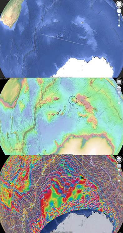
These are identical perspectives of the impact site available to everyone with a computer and Google Earth. The upper is the standard view with superimposed diameter measuring 2500 km; the middle is a bathymetry map depicting raised regions of deposits borne by the impacting object – the circle identifies the location of the nucleus remnants (RGB color scale corresponds to highest to lowest elevations); the lower view is a magnetic anomaly map (RGB scale corresponds with most to least intense susceptibilities). Magnetic anomalies extend 1500 km to the northeast through the impact crescent’s gap. We note that the maps constitute data that had not been available to geologists or other scientists until recently.
In the Oort Cloud where this object formed, gravitational accelerations induced by the solid, inner core were less than 1% of Earth’s. Aggregations forming the outer water-ice and debris shell made it more massive than the core, yet accelerations induced by the combined system were on the order of 2% of Earth’s. These small accelerations explain why the impacting object was so loosely packed, porous, and fragile, as well as why its impact effects on the Earth are so unimpressive and far less damaging than what might be expected from a similarly sized but solid object.
The object that struck (in what is now the Southern Ocean) created the nano-diamond layer, it caused the YD climate changes, and it flooded the planet by adding more than 3 km to former ocean depths.
The waters preserved the many submerged river drainage systems that we can now “see” with Google Earth in the bathymetry. Here are some examples:
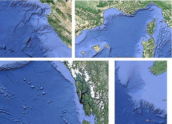
To anyone but a trained geologist the noticeable, meandering features are submerged river drainage systems.
Yet one of the four is published by geologists as having drainages that were subaerially carved, and it is the one in the upper right (western Med) – Garcia-Castellanos (Nature, 2009) claimed that the Med flooded through the Strait of Gibraltar (their timing is way off, however). We note that the former drainages in the Med end at a common depth because carving/erosion is a subaerial process that ceases upon contact with a terminal body of water. Like those in the Med, the drainages in the other three examples were also subaerially carved and seeking their terminal bodies of water. They are preserved because they were quickly submerged by the flood waters.
Here is a schematic from the Nature paper that depicts the waters beginning to enter the Med. Note the there was a body of water in the Med and that for millions of years the waters drained into it, thereby carving the features that are now preserved in the bathymetry, which we can now “see” via Google Earth.
Submarine geomorphologists (and other geologists) conjecture that turbidity flows carved these submerged drainages because to them there was never a worldwide flood. But it is an absolute, physical impossibility for any flow to remain focused and energetic at the depths and distances involved to carve these structures. Geologists are fitting data to theory, and that is the practice of anti-science, or fantasy. Also, ascribing the structures’ creation to subsurface flows is the confusion of cause and effect: whatever turbidity flows that have been observed near these structures are consequences of the structures, post submersion, and certainly not their creation mechanism. To think that subsurface processes carved these features is equivalent to believing that all celestial bodies orbit the Earth.
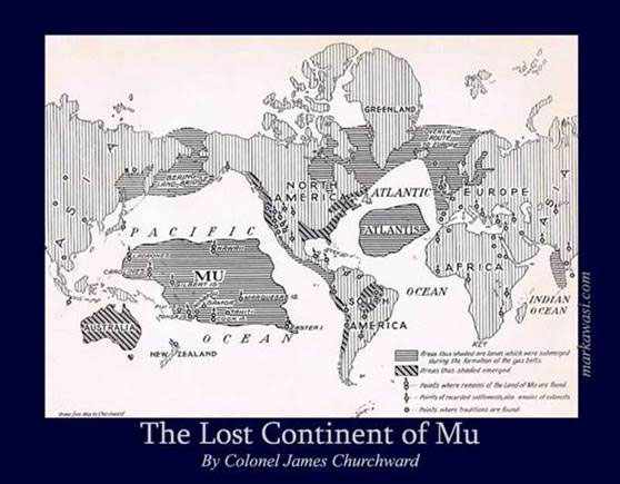
COL James Churchward’s work (e.g. The Lost Continent of Mu) is discredited because of the “no flood, ever” paradigm. Nonetheless, here is a map he created roughly 100 years ago based on his travels and research – note the location of Mu.
Now here is a three-color GIS-produced map (model) of pre-flood Earth (blue = former seas; tan = formerly exposed landscapes; yellow = presently exposed landscapes) created by removing more than 3 km water from Earth’s surface:
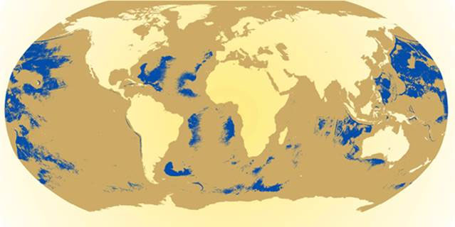
Note the formerly exposed region to the west of South America, particularly its western extent, in the GIS-model, and compare it to Churchward’s Mu.
There’s more: this recent finding included a human DNA “heat map”:
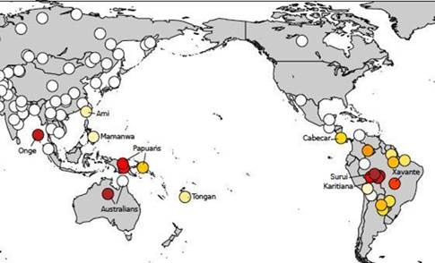
Explaining the heat map is obvious in the context of the worldwide flood: peoples inhabiting Mu shared a common ancestry, and descendants of flood survivors in Australia and regional Pacific islands are DNA-linked to descendants of flood survivors in South America. (By the way, the hypothesis that human migrations to the Americas via some land bridge near the Arctic Circle is wholly invalidated by this map.)
In October 1962, the research vessel Anton Bruun discovered what appear to be human artifacts in the deep abyss. This is a photo and its corresponding caption from the voyage:
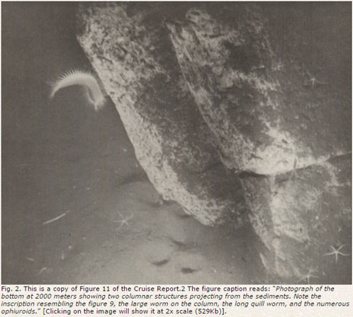
From the voyage report:
“Columns under the Sea – or – unusual rock formations off Callao, Peru, at a depth of 2000 meters some exceptionally interesting photographs were obtained. The figure shows two columnar structures projecting from the sediments…. It is tempting to suggest that these represent evidence of submerged man-made structures. The apparent “inscriptions” on the columns is suggestive as is also their upright condition. The absence of typical submerged rock exposure is further suggestive that these photos have recorded more than just sedimentary rock exposure. The possibility certainly exists, even if the probability is low, that these photographs do show evidence of submerged man-made structures….”
The columns are remnants of human activity from Churchward’s lost continent, Mu.
In addition, if you are familiar with Dillehay’s Monte Verde, then you would know that he conclusively places humans in South America between 12,400 and 12,800 years before present. Also, the Haida (noted seafarers) have been dated as far back as 13,000 years ago. Each settlement’s time estimate corresponds with the YD nanodiamond layer creation and the associated climate effects that were caused by the cosmic impact in the Southern Ocean that delivered the worldwide flood.
Humans evolved in the former abyss where, in the absence of more than 3km water, atmospheric pressures would have increased temperatures – it is why we are furless. Correspondingly, our furry relatives evolved in landscapes that were more than 3km above the former sea level – it was much, much cooler up here (prior to the flood), and we encounter them now because we survived into available landscapes. Most important is this implication: we humans are not properly adapted for the post-flood Earth environment that we encounter. Hence our problems….
It is only a matter of time until other evidence of human activity is discovered in the deep abyss. At that time what will geologists do (other than try to discredit the findings)?
But the bottom line is this: geologists are preventing us from achieving a correct understanding of Earth and human history, and the community of scientists needs to be made aware of geology’s nearly 200-year old, fundamental, paradigmatic “no flood, ever” error. It is perhaps the most profound error in the history of science.
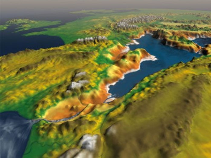
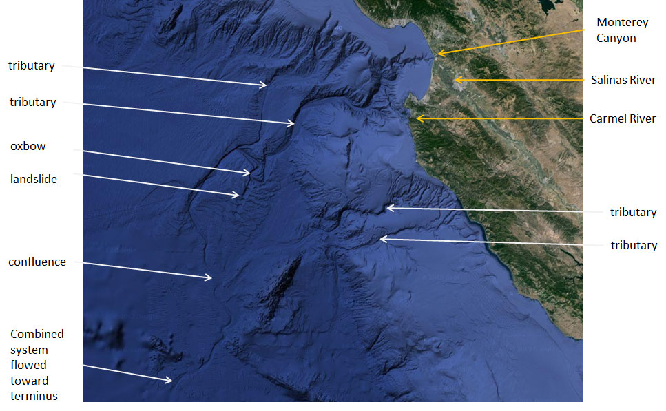
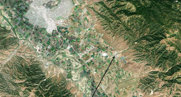
2. The rapid introduction of such a vast amount of water preserved the Monterey Canyon drainage system. The figure below depicts an annotated Google Earth map of the region that was drained by the system. At more than 3 km above the former sea level, what is now California would have been continuously inundated by rains caused by winds uplifted by the nearly vertical and formerly exposed continental margin. Eventually those rainwaters would have been energized by the fall back down the shelf, leading to the creation of Monterey Canyon; this process explains the many other well-preserved river drainage systems found submerged throughout the planet. The confluence region in the figure is ambiguous or smeared as a consequence of river borne sediments being deposited into rising ocean waters, much like the formation of river deltas. This accounts for the nature of a U.S. Geological Survey sample core drilled in this confluence region: it is primarily composed of terrigenous sand, and its secondary composition is terrigenous gravel deposits. Other river-borne materials that were deposited into the rising ocean waters account for the region’s sediment-filled channels.
3. Evidence from coastal California also demonstrates what the worldwide floodwaters did to the local ecosystem. The following image is an overhead view of the Salinas Valley, not far from where I am writing this. It was once a lakebed, and the former water level can be discerned on each side of what is now the valley. This region was once two miles above the former sea level, and uplifted winds condensed to create persistent rains that eroded the hills and filled the lake (these waters would eventually drain to the northwest, and energy acquired in the two+ mile fall back down the shelf is what carved Monterey Canyon). The arrow points to the only (intermittent) stream in the valley, carving its way toward the Salinas River as it drains the series of arroyos and hills to its east and northeast. It demonstrates what 13,000 years of erosion looks like.
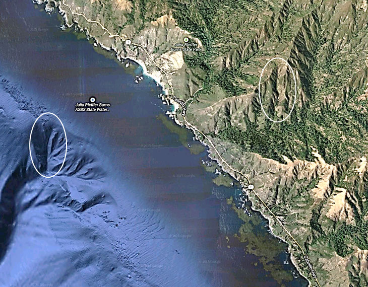
4. Not far to the south of Carmel, CA, is the Big Sur region, a part of which is shown below in a Google Earth image. Two nearly identical valleys are circled, one far below the present ocean surface and the other subaerial (the submerged feature is far too deep to have been covered by melt waters from the last ice age). The valleys have nearly identical dimensions (vertically and horizontally). Under Geology’s “no flood” paradigm, this would imply that subsurface erosive processes are identical to subaerial erosive processes, an absurdity when one considers the immense density differences between the media. The only way that the two features could be so similar is if the now submerged feature was subaerially carved and then later submerged.
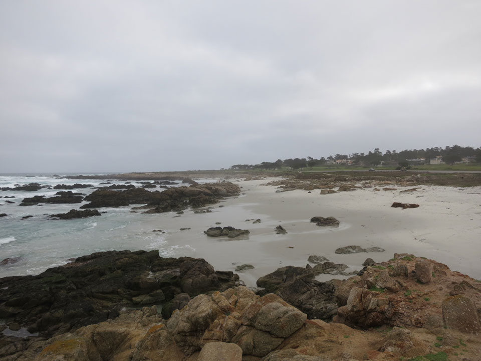
5. Rocks in the surf, those protruding from the beach, and those well above the beach (foreground) all show identical erosion. This would be impossible had the rocks in the ocean been exposed to pounding surf for eons. The relatively recent introduction of the ocean waters accounts for the similarity in the wear of the various features – all the local formations were subjected to identical erosion for millions of years, and the upper layer of soil was removed by the recently introduced ocean waters, and the past 13,000 years of surf erosion has not created a discernible difference in the rock formations.
In addition, the rocks in the surf are jagged, an impossibility had they been exposed to pounding surf for billions of years.
6. Having formed in the Oort Cloud, the outer layer of the impacting object was consistent with known comet composition: porous, mostly open space, “unbelievably fragile,” and “less strong than a snowbank” – descriptions from Prof. Michael A’Hearn, project lead of NASA’s Deep Impact mission into Comet Tempel 1. In the Oort Cloud where this object formed, gravitational accelerations induced by the solid, inner core nucleus were less than 1% of Earth’s. Aggregations forming the impacting object’s outer water-ice and debris shell made it more massive than its core, yet accelerations induced by the entire object were on the order of 2% of Earth’s. These comparatively small accelerations explain why the impacting object was so loosely packed, porous, and fragile, as well as why its impact effects on the Earth were far less damaging than what might be expected from a similarly sized but solid object.
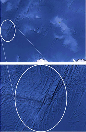
Despite the fragility in its outer layers, the force of the impact nonetheless shifted local topography in the western edge of the crescent by up to 150 km; terrain elongations are evident in the Google Maps (satellite view) images of the impact crescent’s western extent, shown below. Deposit mounds interior to the crescent are remnants from the melted mineral-ice complex that comprised the impacting object’s outer layer.
Another important consequence of this impact: common, smaller, and irregularly shaped comets are fragments from these larger objects that have broken off due to eons of gravitational interactions.
To my knowledge, the long standing “theory” that comets are composed largely of dirty ice, has not been borne out in recent probes. Alternately, plasma physics as tested in the lab and described by The Thunderbolts Project, offers a more likely explanation for the phemomea that led to this initial theory.
Lawson,
NASA’s Deep Impact into comet Temple1 found that comets were mostly open space and predominantly comprised of ice. See:
– A’Hearn M, et al. (2005) Deep Impact: Excavating Comet Tempel 1. Science (310)5746:258-264.
– Susnshine J, et al. (2007) The distribution of water ice in the interior of Comet Tempel 1. Icarus 190:284-294.
– Kerr, R (2005) Deep Impact finds a flying snowbank of a comet. Science (309)5741:1667
The object that struck Earth in what is now the Southern Ocean is the source of the smaller comets we encounter. This object was likely brought to our solar system by a binary star system that passed through the Oort Cloud roughly 70kybp (see Mamajek E, et al. (2015) The closest known flyby of a star to the solar system. ApJ (800), L17).
The comets we observe are but fragments from these large but fragile objects.
I have always wondered if such an occurrence would change gravitation on Earth since the mass would have changed. I would also think that the spin rate of earth and/or orbit may also have changed.
Less spin would lead to longer days which would lead to more sunlight.
Which would help explain why prehistoric flora was so much bigger.
All good information. Trying to catch up. Thanks for more to think about 🙂
Excellent excellent!!!
Excellent news excellent work
Thanks for your research. I grew up in Pacific Grove, and so have always known about the deep deep trench off the Monterey coast (beware of riptides!) and used to tell friends that there were monsters living way down in those depths…
I’m curious, though, if there’s any room in your theory for the expanding Earth model? Neal Adams has gotten a ton of grief for his video simulation, but in it he does make a fascinating point about the Pacific Ocean…the age of the ocean floor, specifically.
When I look at the three-color GIS-produced map and the DNA “heat map” I’m only more intrigued by the idea that Asia and the Americas were once connected (we learned in grade school that Japan and California had super similar, almost identical, flora and climate, though thousands of miles apart).
Could Mu have been a low-lying landmass that broke apart at fracture zones on its eastern and western sides, and was so “dislodged” from its moorings, so to speak? As the Earth expanded, if we flirt with this theory, the gaps between Asia, Mu and the Americas (and Antarctica for that matter) would have widened. Based on fault line data, it’s almost tempting to imagine that the Ring of Fire seismic zone itself may have caused the landmass between the current continents to “sink” or lower as a whole when all sides of the current Pacific fractured at highly active fault zones. It’s tempting to see the Pacific Ocean floor as almost a loose plate, sinking deeper as a whole as the planet expands…
Add that to your comet concept, and something interesting emerges…
Ironically, I live in Iceland now, so my current reality is all about the land I live on splitting apart, expanding, rising. I must really love earthquake zones!
(P.s. I’ve always been fascinated by the idea of the Azores, all alone out there in the middle of the Altantic, due south of where I am now. Then I noticed on Google Earth the submerged triangle landmass they sit on, and the stories of underwater pyramids surrounding them. Maybe an aspect of Atlantis as well?)
All the best from Reykjavík!
Once again, thanks for your post and video!
Truly thrilling! The linked presentation, Resolving the Problem of Atlantis, was even more exciting than the article, and is highly recommended. I find it encouraging that scientists, and geologists in particular, are actually undertaking the challenges of shifting this paradigm (which otherwise would proceed at a glacial pace. Get it?) and with the excellent scholarship of fearless explorers like Michael Jaye and others, I believe we’re going to begin to see REAL changes in understanding very soon. Thank you for sharing!
This certainly has resonance with Graham Hancock’s recent publication Magicians of the Gods which despite the title is a serious attempt to shift the paradigm currently held and proffer evidence of just such a flood in the YD timescale.
Finally someone is making sense to me. Ive long poured over google earth looking at oddities and thinking about a cataclysm so large it would be hard to tell because everything was affected so one would have nothing to compare it to. You kept me up way past my bedtime. Well done!
Hi,
I enjoy Mr Hancock’s work, though am not so sure about this. I’ve not read all the detail, though the claim that a comet filled the Earth’s oceans only 12,000 yrs ago seems a bit much. For reference –
1,386,000,000 cubic km of water in earth’s oceans – http://oceanservice.noaa.gov/facts/oceanwater.html
That would make a sphere 1,383km across. The moon is 3,474 km diameter.
The asteroid that wiped out the dinosaurs was apparently only 10km across – http://www.iflscience.com/revealed-asteroid-killed-dinosaurs-boiled-earth-s-atmosphere
Perhaps this 10km across asteroid was just a fragment and the other pieces hot other bodies of water and ice which melted?
Excellent indeed. The maps appear to be incomplete. SE Asia on around into the area between NW India to the Straits of Hormuz would also have been exposed. From the Gulf of Siam on down to Australia may have been dry land 13,000 plus years ago. The recent discovery of Dwarka in India some 17 km off shore is an example. I would postulate that a major human settlement should be found at the mouth of the Euphrates River where it would have met the ocean at the Straits of Hormuz. The entire Persian Gulf having been a fertile valley at the time. The so called Garden of Eden?
So…… evidence seems to be massing that the world today is probably not the pinnacle assumed to be… more than likely society is currently the way it is as we are still coping with at least a couple of pretty horrific previous doomsday scenarios, set now into legends and folklaw. I have often thought about recipes and similar cookery of hitherto unconnected places that did not have a good enough explanation to me as to why the cuisine of one place resembled dishes from more distance and sea separated geographical regions. Wondering still about it all…
I can fully accept many of the conclusions here based on the evidence presented, including the Southern Ocean impact site. I’m still more inclined however, to the North American ice-sheet impact hypothesis to explain rapid sea-level rise. The evidence presentd by Hancock / Carlson, such as the heavy sedimentary deposits, their associated water flow features along with other high volume water erosion features, seem more compelling. There is equally compelling evidence that such ice-sheets (the Laurentide and Barents-Kara Ice Sheets), were present at the last Glacial Maximum as to be beyond dispute. Their hypothesis also fits more comfortably with the YD temperature variation as does the required water volume creating the more modest 400ft sea-level rise. It’s always prudent to examine all possibilities nevertheless, and most of the evidence presented here supports either hypothesis.
Thanks for that brilliant lecture. I would like to inform you as to why those core samples of the comet’s centre have high gamma readings. I believe it originated from a planet called Maldek that fairly recently existed where the Asteroid belt now is between Mars and Jupiter. There were beings similar to us living there at the time, and also on Mars. They had a nuclear war between them, and in a skirmish set off a chain reaction of nuclear blasts that ripped apart the entire planet, also blowing the atmosphere off Mars.
Perhaps these comets are from the asteroid belt, and still contain chunks of that planet and its ocean. (Explaining the formation of carbonates in the core data)
This came to a friend of mine during a DMT trip.
Enjoy looking into that one.
well interesting ”BUT ” the earth is only about 7 thousand years old . see I believe in the BIBLE , all the chapters / pages etc ……/ thank you you got ome nice data / pictures
Hi all , Global flood 100% fact ! As for Atlantis , I Have conclusive proof of its whereabouts. A book will lay all the cards on the table. Praises to God.
The location of Atlantis is described in this presentation: https://vimeo.com/126026401.
I hope that it matches the location for which you have conclusive proof.