


By Deepak Bhattacharya 1 & P. C. Naik 2
Edited by Sharif Sakr
Abstract
The location and design of the ancient temples of Bhubaneswar have been guided by rich astronomical insight. Not only temples, even the painted hill caves, ancient forts and river docks have been placed and constructed in accordance with the location of individual stars and with outlines of constellations that have related shapes or star-lore. Individual monuments have corresponding stars, and as a group they form a similar pattern on the ground as they do in the sky above. The star-temple correlation is centred on the constellation of Orion, which is reproduced in its entirety.
Location and Historical Context
Bhubaneswar is located 20.05° North / 85.82°East, on the Eastern coast of India. As the present administrative capital of Orissa province, it is globally well-connected. The modern city covers around approximately 30 square kilometres, whereas the ancient monuments are clustered in an area of 10 sq. km, termed the core area in the INTACH[1]-EKAMRA heritage conservation plan of 1989. Ekamra is the name given to Bhubaneswar in the ancient literature. The historical period of the Bhubaneswar monuments covers two millennia, between 300BC and 1600AD. This architectural heritage includes Jaina, Buddhist and Hindu sites (the latter being most recent and numerous). The names and cultural classification of the 28 main archaeological sites is given in Fig. 1, along with code numbers from 1-28 to allow easy reference later on.
- Oddisi Research Laboratory , Kedargouri Road, Bhubaneswar – 751002, India.
- Dept. of Physics, Dharanidhar College, Keounjhar – 758001, India.
[email protected] & [email protected]
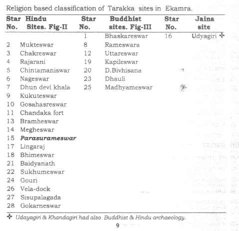 |
| Fig. 1 – Table showing main monument sites of Bhubaneswar, with religious classification. |
Introduction
The celestial bodies have fascinated man since his beginning. Not only has he observed and recorded celestial phenomena, but he also appears to have felt an urge to design and locate religious buildings in line with individual stars or constellations [2]. It is as if he wanted to make reflections of the heavenly bodies on earth. There are reports on the astronomical connections of historical monuments in Egypt, Central America, Northern Europe, Cambodia, Egypt, Indonesia, Polynesia and elsewhere. But none have been reported from the Indian subcontinent. This is strange, considering that India is the very geographical zone in which the Sanatana, Jaina and Buddhist religions, with all their abundant astronomical fascinations, flourished.
From the Vedic period, celestial observations in India evolved into a systematic science, called Siddhanta, which has survived even into modern times. Authorities like Aryabhatta, Varahamihira, Bramhagupta, Baskaracharya, Satananda, Samant Chandra Sekhar and many more have left invaluable contributions, including observations, calculations and instruments; thereby maintaining an uninterrupted tradition for about 1500 years. This tradition has exercised immense influence on society by way of elaborate prescription of ideal dates and times for observance of religious and social functions, including birth and marriage.
The Rig Veda contains a concise description of stars and constellations. It is indeed an ode to the cosmos, in limited diction, of unparalleled quality and antiquity. The Rig Veda refers to Orion as Kala Purusha, Yajna purusha, Yajna Soma, Rudra, Ekadasa Rudra, etc., and it emphasises the importance of this particular constellation. The abstract cosmic divinity of Orion in the Rig Veda assumes physical forms in anthropomorphic and zoomorphic chitrabasha artwork, which is found in abundance in Bhubaneswar. It also may be expressed through the aniconic symbol of the Siva Linga (the phallic stone within a circle, representing Siva-Shakti), the shape of which matches the Orion constellation when viewed from the side in two-dimensional profile (i.e. as it is represented in temple art). Expressed in these ways, Kalingan archaeology reveals a central importance of the Rudra and Kalapurusha stars, and of astronomy in general.
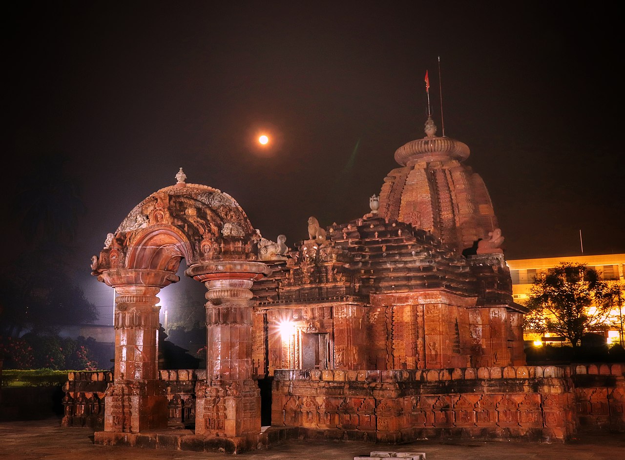
The ancient city of Ekamra/Bhubaneswar is a prominent Saivic site with hundreds of Siva temples, some of which are world-famous (the Lingaraj, Parasurameswar, Rajarani etc.). It was also centre of Kalingan trade networks, which extended across the Bay of Bengal and included the Indonesian Archipelago. Kalingan mariners were surely adept in identifying stars as navigational aids in the high seas. This knowledge could have spread into wider Kalingan society, reaching the educated elite including the royalty and master craftsmen, who together patronised and constructed the ancient Kalingan monuments.
The concurrency of Vedic astronomical traditions and astronomical maritime navigation practices with a long historical period of building activity begs the question of whether or not the Kalingan temple-builders were influenced by Vedic astronomical concepts. Did they attempt to align their temples with stars or constellations that are important in Vedic astronomy?
Materials and Method
Extensive field study was conducted, covering all the ancient archaeological sites in the Ekamra Heritage Zone. A map of heritage sites in Bhubaneswar was superimposed on a star map in order to judge correspondence (Exp. 1). A theodolite survey was then conducted in order to obtain accurate measures of the angular relationships between ancient structures in Bhubaneswar (Exp. 2). Ecclesiastical practices, mythic lore and architectural phenomena associated with each ancient site were noted, and compared with the Siddhanta lore surrounding the geometrically-correlated stars and constellations. All data were fed into three-dimensional imaging software to produce accurate virtual images of the ancient buildings, stars, and their correlation (Exp 3.). This has never been done before in India.
Experiment One – Map Superimposition
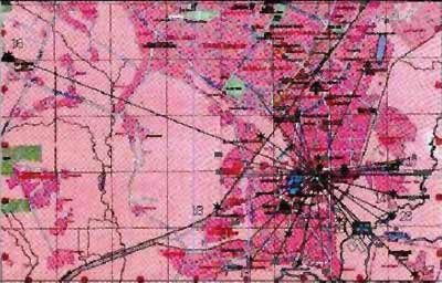
The standard Survey of India tourist map for Bhubaneswar [3] has some of the monuments marked on it. The authors marked other monuments, with reference to a standard INTACH map, giving a total of 28 marked monuments. Each monument was given a number code between 1 and 28, as in Fig 1 above. The zone in which all the monuments lay covered only the lower half of the map, and this section was scanned and reproduced at 1/3 scale [4]. All marked monuments were radially connected with straight lines to the Parasurameswar temple, to produce a starry pattern with the Parasurameswar temple at the centre. We call this starry pattern Tarakka. The terrestrial Tarakka was then compared with star map, centred over the star Betelgeuse (α Orionis), which is known as Rudra, the “red hot star”, in Siddhanta astronomy. Where the angles roughly matched up, the corresponding stars were given the appropriate number code, to pair them with the matching terrestrial monuments. The reasons for using this method of comparison are explained below.
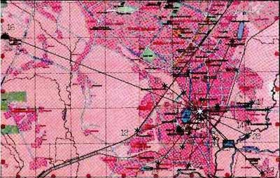 |
| Fig. 2 – Survey of India with Terrestrial Tarakka |
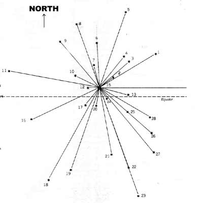 |
| Fig. 3 – Star positions in the night sky, based on bi-polar zenithal view standard star map (Ref. 13). |
 |
| Fig 4 – Theodolite Readings. |
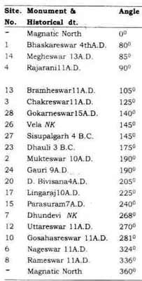
Experiment Two – Theodolite Survey
To verify the reliability of the Survey of India map, we decided to test the angular distances between monuments using a theodolite. Metro Mansion, a tall multi-storeyed building was selected as the base of the theodolite readings, because its roof offered a good view of all the main monuments, and it was only around 500ft NE of the central Parasurameswar temple (site 15). The theodolite [5] was calibrated and aligned to magnetic north (MN) with a compass [6] and positioned on the south-east corner of the building. Readings were taken in clockwise order from MN, starting with site no. 1. The angular difference between a) two monuments and b) the gross offset from MN was measured and recorded ( Table I ). Due to obstruction by a water tank of the field of view between angles 240° and 350° along the Western horizon, the theodolite was repositioned on the NW corner of the building, reset and re-calibrated with the standard reference and the NS baseline. Due to these adjustments, both theodolite positions can be taken as one, called TP. Interestingly, no monuments were found in line with magnetic north or south, such that the north-south is not emphasised. In contrast, the east-west line is prominently represented in both the terrestrial and celestial schemes. To us, this suggests that the east-west line is the more important basis of calculation in Siddhanta astronomy.
A theodolite-based (and hence partial ) Tarakka was superimposed on the Survey of India map, with TP centred on the appropriate position on this map (see Fig. 4). This superimposition confirmed the basic terrestrial Tarakka as previously judged (in Exp.1) from the Survey of India map. The few slight mismatches in the correlation between the terrestrial and celestial Tarakkas can be at least partially explained by the polar view zenithal projection of the star chart we used to draw the celestial Tarakka, which is different from the zenithal equal projection used on the Survey of India map used for the terrestrial Tarakka.
 |
| Fig 5 – Superimposition of theodolite-based Tarakka onto Survey of India map. |
Experiment Three – Computer Simulation
Using Iron CAD software a three-dimensional model of the celestial hemisphere was generated, with the help of a Japanese star globe. Angles measured from the centre in reference to vertical and horizontal star positions (declinations and longitude) were determined, such that a celestial dome was formed. This dome was then reflected onto a representative 2D horizontal plane (RHP), by vertical cascading of the stars. Monument positions were then mapped onto the RHP for comparison. The celestial dome and RHP could both be rotated at will to offer virtual reality viewing of the celestial and terrestrial Tarrakas simultaneously. Figure 6 below shows a sample image from IronCAD, comparing the reflected star positions (represented by small coloured domes) with the positions of monuments (figuratively represented). The superimposition is centred over the star Betelgeuse and the Parasurameswar temple, which is coloured red. The arrow represents north for the stars and magnetic north for the temples.
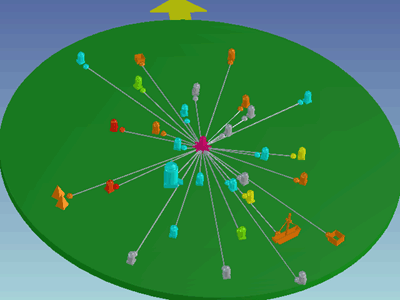 |
| Fig. 6 IronCAD image comparing star positions with monument positions. |
The Nature of the Star-Temple Correlation
The correlation we are presenting is approximate, not exact. The star and ground maps we have been using have different projections. Moreover, the star chart we used to draw our celestial Tarakka shows star positions for the date 2000AD. But the hub of the terrestrial Tarakka dates to between 2300 and 1300 years ago and is on +20 degrees latitude. It may be possible to use find a date when the correlations is more exact, and this may have some bearing on the origin of the embryonic Tarakka – the initial idea to mirror the stars using temples. However, this will be complicated by the fact that all the sites involved in the Tarakka were not built at the same time. Since this is the first article to present the Tarakka hypothesis, we will focus on showing that a meaningful sky-ground correlation exists today, even though it is not precise. Issues relating to mismatches in precise angles, and their possible usefulness in dating either the embryonic Tarakka or the individual buildings involved in it, will be left for another time.
Key Star-Temple Associations
The key point in our attempt to investigate the possibility of astronomical traditions in Kalingan architecture was the identification of reference stars and corresponding sites on the ground. Three clues were hit upon fairly easily:
α-Orionis, the ageing red giant known as Rudra (Betelgeuse), is sung about vociferously in the Rig Veda, and it corresponds in many clear ways with the Parasurameswar temple in Bhubaneswar. The name of the temple means “Siva with a battle-axe” and temple artwork expresses the terrific or war-like aspect of Siva, which is easily compared with the “red-hot” star of the Orion constellation. Unusually, the temple was originally painted red and some traces of this paint remain.
β-Orionis, alias Rigel, is identified with a bow and arrow held by a hunter or warrior, in both Siddhantic and Western star-lore. Indeed, the star’s Siddhantic name, Bana raja, means “king with arrow”. It is the brightest star in the Orion constellation. The spire of the Lingaraj temple sports a bow and arrow (Dhanu-O-Pinaka), and is totally unique in this respect. It is also the tallest monument, reaching 180 feet.
The combined monument site of Rameswar-Laxmaneswar offers an uncanny similarity with the constellation Cassiopeia (Kasyapa). Moreover the names of the individual monuments within this site seem to bear relationships with the Siddhantic names for the constellation’s component stars.
Studying the angular position of α-Orionis, α-Cassiopeia and β-Orionis in star maps and making angular comparisons (Exps.1-3), it became abundantly clear that a 1-to-1 correspondence might be feasible and worthy of further investigation.
The Tarakka
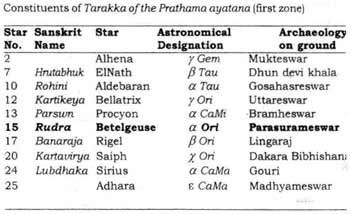
Regional sub-epics talk about the “Forest of Tarakka”, wherein the Lord Siva is said to have appeared for the first time, at the center of the Universe. On a star chart, the star α-Orionis can be joined with imaginary radiating lines to various other stars bright or culturally important stars, forming a starry pattern or “inter-star” in which α-Orionis/Rudra is at the center. Using the map and, wherever possible, the theodolite results, the monuments on the ground can likewise be joined by radial lines to the central Parasurameswar temple, which represents both Betelgeuse and Siva, creating a terrestrial image of the inter-star. In view of the mythology, we will call this inter-star pattern “Tarakka”. Because the angular distances between the stars in the celestial Tarakka, and the angular distances between the monuments in the celestial Tarakka are approximately equivalent, the terrestrial Tarakka can be easily correlated with the celestial one (see Fig. 6). The concept of the Tarakka pattern compels us to exclude any other star or monument as the central one, because an inter-star pattern cannot be replicated using any star other than Rudra, or any temple other than Parasurameswar. The celestial Tarakka comprises of 28 stars, arranged in a pleasing three-tiered format, with each tier (ayatana)having nine stars. The same system applies in the terrestrial Tarakka. The star-temple correlations of each tier will be detailed below.
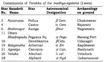
First Tier of the Tarakka
The location of the most spectacular constellation, Orion, is relatively central in the sky, as seen today, with one half in the northern hemisphere and the other half in the southern hemisphere. It has been visible between +20° and -20° latitude roughly overhead every night for thousands of years. The prominent stars (listed in table 3) around Orion with Betelguese in the centre may be joined to form a small Tarakka, which represents the inner tier (prathama ayatana) of the wider Tarakka described above. The corresponding sites on the ground are given in the last column of the table in Figure 7. The identification of these corresponding sites is entirely based on the angular distance between the stars in the sky.
 |
| Fig. 7 – Table summarising First Tier of Tarakka |
As mentioned above, the Parasurameswar and Lingaraj temples both also contain clear internal clues as to their relationships to the stars of Betelgeuse and Rigel respectively. Such clues can also be found for two other temples in the first tier. The star Sirius (α-CaMa), which is the brightest star in close vicinity to Orion, is called “Lubdhaka” in Siddhanta and is referred to as a consort of Rudra. On the ground the corresponding monument is that of Gouri, located almost adjacent to Parasurameswar. Gouri is the site of an annual ritual in which the presiding deity (who has been Lingaraj since the 10th Century AD) leaves his temple with a priestly entourage and travels to the Gouri temple in order to get married. It is interesting to speculate that before the 10th Century, when Siva was the presiding deity and Parasurameswar was the primary temple, the marriage ritual involved the Parasurameswar and Gouri temples, mirroring the Siddhantic connection between the stars of Rudra and Lubdhaka. Today, the head priests of these two temples are still from the same family.
Aldebaran (α-Taurus) is another star in the first tier of the Tarakka. It is quite close to Betelguese but lies in the zodiacal constellation of Taurus. The bull is theriomorphic insignia of Lord Siva. The bull is his vehicle and also his zodiacal birth sign. The temple which corresponds with α-Taurus is Gosahasreswar, which means “Lord of a thousand cattle”.
Site No. 25, the Madhyameswar temple, correlates with the Adhara star (ε-CaMa). This temple was built on the site of a Buddhist pillar, which was converted into a massive Linga (stone phallus). This suggests that this particular location may have been consecrated even before the Hindu period.
Second Tier of Tarakka
The second tier includes nine more stars, all of which can be matched with temples on the basis of geometry – see Figure 8 below.
 |
| Fig. 8 – Table showing correlations in the Second Tier. |
In addition to the geometrical correlation, there are internal relationships that deserve mention.
The star Canopus is called Agastya in Siddhanta and correlates with the Baidyanath temple. In the Indian system of medicine (Ayurveda), the medicinal plant Sesbania grandiflora (L) is called Agasti. Baidyanath means lord of doctors.
The stars Pollux and Castor of the Gemini constellation represent, in Siddhanta, the heads of a loving couple. Castor, which is the brightest star in the Gemini constellation, is geometrically correlated with the Rajirani temple, which literally means “King and Queen”. This temple is dedicated to love, beauty and feminine grace.
Pegasus Square is a prominent geometrical shape of four bright stars, which are joined with other stars in the Pegasus constellation that form the flying horse of Greek star-lore. Pegasus Square is geometrically correlated with the Barangagada fort (now in ruins) which lies in the north-west outskirts of Bhubaneswar city. The square shape of the constellation matches well the shape of the fort walls [7].
The star Deneb-Kaitos is the constellation of Cetus, which has the form of a pair of triangles. The corresponding monuments are the pair of hillocks, Udayagiri and Khandagiri. These hillocks contain ancient Jaina, Buddhist and Hindu cave and rock art, including the famous rock edict of emperor Kharagola (dated to between 1st Century BC and 2nd Century AD).
The star Alsuhail (Velaka in Siddhanta) in the constellation Vela geometrically correlates with the site on the Western bank of the Gangua river that has previously been identified as an amphitheatre. The word Vela means “raft” in the Oriya language. Its shape in occidental star maps is that of a boat with unfurled mast. We have investigated the ‘amphitheatre’ and strongly suspect that further archaeological investigation will reveal that it was actually a dock. It consists of a low-lying square structure bounded on three sides by land, and with the fourth side opening out to the river. The structure bears much similarity to the Harappan dock at Lothal in Gujerat [8], and we believe it is an inland river dock of ancient Kalinga. We suggest that the site be renamed as “Vela dock“.
Third Tier of the Tarakka
The star-temple correlations in the third, outer tier of the Tarakka pattern are summarised below in Figure 9.
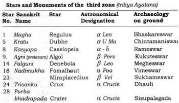 |
| Fig. 9 – Table showing correlations in third tier. |
We will now discuss in detail the non-geometric relationships between certain temples and their correlating stars.
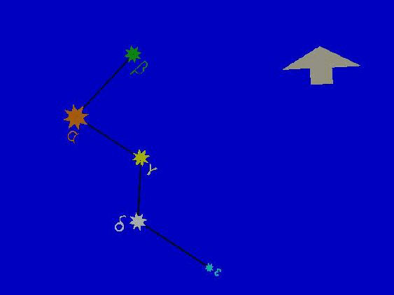 |
| Fig. 10 – Diagram showing Cassiopeia constellation. |
The star Regulus is the brightest star in the constellation Leo, and it correlates amazingly with the site of a very ancient Mayuran Lion centre. This centre was demolished at some point in history, converted into a massive Linga and subsequently into a Siva temple called Bhaskareswar. The roof of this temple is characterised by flame-like wisps of sculpted stone, which give a fiery or Sun-like impression. Fire and the Sun are both associated with the Leo constellation in Western and Eastern star-lore. In Western and Eastern astrology for example, Leo’s ruling planet is the Sun and its element is Fire.
The five stars of Cassiopeia correlate with five temples on the ground, not only in terms of their positions relative to the central position of Rudra/Parasurameswar, but also in terms of their positions relative to each other. The five stars of Cassiopeia are arranged in an extended W-shape, and this is well mirrored in the relative positions of the five temples on the ground. A diagram of the Cassiopeia constellation is show in Fig.10, and the correlation is summarised in the table in Fig. 11 below.
Again we find that before these Hindu temples, this site had Buddhist architecture that was deconstructed and converted into Hindu architecture. Following this history, the Lord Lingaraj travels from his own temple to this site to represent his victorious banishment of the Buddhists from Kalinga.
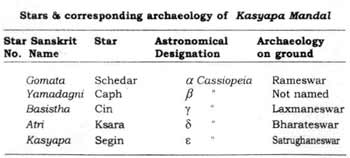 |
| Fig. 11 – Table showing Cassiopeia correlation. |
Small Stars
Some small stars are identifiable with lesser known monuments. For example, Manibhadreswar and neighbouring east-facing Lingas correspond with the body of the bow held by Kalapurusa in the Orion group. Similarly, the 32nd star of Orion is the corresponding star for the Taleswar (9th AD) and Hrutabhuk (El Nath) monuments. Star No. 7, which is associated with Agni corresponds to Dhun devi khala where the Bhois annually perform the rutual of walking on burning charcoal and fire on the month of Ashok Astami (month of Aries). Manibhadreswar and neighbouring east-facing Lingas correspond with the body of the bow held by Kalapurusa in the Orion
Tarakka of Buddhist sites?
We attempted to recreate the Tarakka using only sites that contain Buddhist relics or remants, with site no.12 (a formerly Buddhist site) as the hub star. It was not possible to produce a Tarakka using these sites, and this may suggest that the Tarakka reflection is of Hindu rather than Buddhist origin. The Buddhist Sundas and Satavahanas have left behind a large amount of art depicting various types of boats and masted ships, but nowhere is there any art or archaeology relating to astronomy or maritime navigation. Such art and archaeology is far traced only to the Hindu Kalinga period.
The Orion Constellation (Kalapurusha mandal)
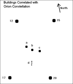 |
| Fig. 12 |
Figure 12 shows a diagram of the buildings that we think represent the Orion Constellation and Figure 13 summarises the correlation of temples with stars. This correlation comprises of stars/monuments nos. 12, 15, 17 and 20, plus the three belt stars (z Ori, e Ori, d Ori) which correlate with the buildings marked a, b and c respectively. The nebular pair (M-42 and 43) correspond with the monuments (d) of the Ganja-Jamuna complex and Laxmiswara. These sites face east and are in a north-south line much like the blue star triplets that mark the scabbard of the Orion warrior/hunter. It is interesting to note that site 12 faces 15 and 17 faces 20. Site a faces c while b faces north. Sites 15 and 17 face opposite directions (non-co-linear, as in star maps) and are ex-Buddhist sites.
The author Bhattacharya identified in the 1998 the remains of an Mayuran Lion center at site 20 and has proved the present Linga is comprised of a portion of the pillar, while a defaced Lion head is placed near the north gate. In other words sites 12 and 20 were originally Buddhist sites, while 15 and 17 are original Hindu sites.
It is also interesting to note the similarities between the words Orion, Oriya (the language of the Oriyas, the people of Orissa), Orient (a word generally associated with India and Indo-China, Orissa (the Indian state of which Bhubaneswar is the capital) and Oryza Sativa Linn (rice, the staple diet of Orissa). Prof. Dr. B. P. Choudhury has identified rice in the temple art of the Parasurameswar temple. The architectural and astronomical pursuits of the people of the Oriyas seem to concentrate on the constellation on the constellation of Orion. While we cannot conclude anything from this, we just wish to note is as something interesting and possibly significant.
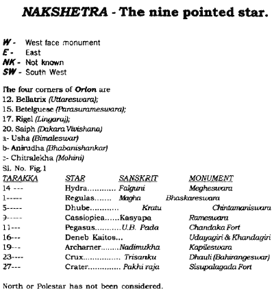
| Star No. | Sanskrit Name | Star | Designation on ground | Astronomical Archaeology |
| 12 | Kartikeya | Bellatrix | γ Ori | Uttareswar |
| 15 | Rudra | Betelgeuse | α Ori | Parasurameswar |
| 17 | Banaraja | Rigel | β Ori | Lingaraj |
| 20 | Kartavirya | Saiph | χ Ori | Dakara Bibhishana |
| a | Usha | — | ζ Ori | Bimaleswar |
| b | Anirudha | — | ε Ori | Bhavanisankar |
| c | Chitralekha | — | δ Ori | Mohinee |
| d | — | — | M 42 & 43 | Gangajamuna & Laxmiswara |
| e | — | — | θ Ori | Devipadahara Tank |
| Fig. 13 – Table summarising Orion Correlation | ||||
|---|---|---|---|---|
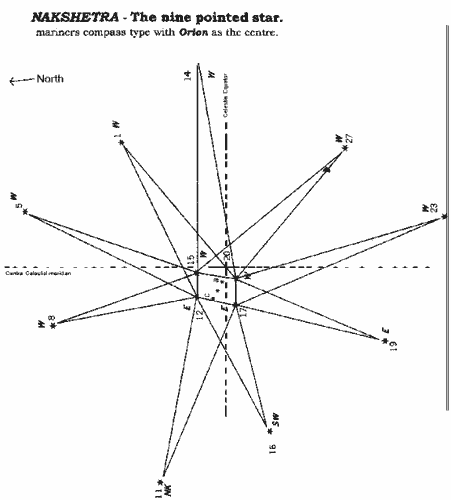
Nakshetra – the star with nine zones
In the above text we have showed that as we look up into the night sky we find a one-to-one correspondence between stars and monuments. In many cases, when we view individual monuments from above, they actually look like stars on the ground.
 |
| Fig. 14 |
Although the Tarakka pattern is infracted if we try to use any star/temple other than Rudra/Parasurameswar as the central point, it does also seem to be possible to create a Tarakka using the four main stars of the Orion constellation. Sites 12, 15, 17 and 20 form a rectangular shape at the center of this terrestrial Tarakka. If we then take only those buildings (temples) that are relatively equidistant from any one or two of Orion’s terrestrial constituents and join them with straight lines from either ends, we get a nine-pointed star (Nakshetra). This Nakshetra can be formed in the sky as well. This is of great interest to us because the Nakshetra is a Vedic concept of very great antiquity. The Nakshetra seems to contain the primary direction-indicators (dikpalas) of the Kalingas. The name Dikpalas literally means “maintainers of directions”, and these pointers are found on the spires of Kalingan temples. When the central star was at or near zenith, the Nakshetra could have acted as a kind of compass, whether on land or at sea. The Nakshetra is similar to the modern 8-pointed compass. In later times it appears that the Kalingas, when representing their dikpalas, reduced the rectangular perimeter of Orion to a square, and reduced the number of direction-pointers from nine to eight. The authors have conducted further research into the use of the Nakshetra as a compass on the high seas and intend to publish it in the near future.
 |
| Fig. 15 |
Our findings regarding the Tarakka and Nakshetra lead us to suspect that use of these patterns may have been central to the astronomy and navigation of the bygone maritime civilization of Bhubaneswar, such that it was considered important enough to be commemorated in their art and architecture. One thing that may be gathered from the use of the Tarakka and Nakshetra, which do not take either pole into account (and focus instead on the east-west line), is that the underlying science predates the time when polaris occupied the North Pole (the time of Christ). One advantage of avoiding dependence on the poles would have been that navigators could have used the same astronomical techniques in either hemisphere.
Dating the Tarakka/Nakshetra
The intersecting point of the celestial equator and the central celestial meridian is an interesting location in the night sky. At some point in the past, Rudra could have reached a latitude of 20.05degrees above the celestial equator, coinciding with the local latitude of Bhubaneswar, such that this important star would have reached the zenith (i.e. it would have been directly overhead, viewed from Bhubaneswar). At this time, the Tarakka and Nakshetra would have been in full effect as navigational aids. Also at this time, e Ori (Aniruddha), the central belt star of Orion, would have been at the intersection of the celestial equator and the central celestial meridian, offering a rare celestial spectacle in Bhubaneswar’s night sky. At that point in time, the tradition of Lord Siva (associated with Orion) appearing in his cosmic form in the center of the universe and performing the Ananda Nataraja (“joyful dance of the King” [9]) may been generated in the minds of the faithful. The author Naik has determined that Rudra/Betelguese was on +20degrees latitude in 104BC. The location of the as yet unexcavated Bhavani shankar monument, which correlates with the central belt star of Orion (Aniruddha) indicates good geometric consonance with the position of this star on the celestial intersection point. Such a central position in the night sky (i.e. the ancient concept of the “center of the universe”) would only have been meaningful if associated with Orion, which in many ways is the central constellation of Vedic, Hindu and Saivic concepts.
|
| Fig. 14 |
Figure 14 shows the Nakshetra as it looks on the ground, composed of the numbered temples. Superimposed on this diagram is the intersection point of the celestial equator and celestial meridian as it was in 2000AD. Fig. 15 contains a key and a summary of the correlation.
|
| Fig. 15 |
The Milky Way
The Milky Way in Indian texts is termed Biyat Ganga, Swargaganga, Akas Ganga and Khiroda Ganga, and it is imagined as the heavenly Ganges or as a river of milk. On the ground, the approximate corresponding path of the Milky Way, as visible between November and April, matches the mariners path along the Prachi river system, via Chilika towards Suvarna dwipa (Indonesia). On the banks of this river system are located the sites of Bhubaneswar, Puri and Konarak.
Bramha Temple
No monument has been found corresponding to the bright yellow star Capella (α-Aur). This star is associated in Siddhanta with the Brahminic super-deity, Bramha. It is conjectured that in the past a Bramha monument did stand in the correct position, between the north-west corner of the present-day Swastik Enclave building, and the Forestry Deptmartment’s Aranya guesthouse. The author Bhattacharya found large sandstone blocks during work on the foundations of the Swastik Enclave building. Ruins of the temple may have been moved during the 20th Century to a new location on the east bank of the Bindusagar. At this incongruous site there is to be found a strange monument with a mixture of early modern architecture and ancient stone sculpture. The ancient remains include a grand statue of Bramha, depicted with four faces in his celebastic form under an ornate arch with the Kalingan Kirtimukha (master craftsman’s seal). The statue is 5ft-high and made of polished black granite.
The Diamond Triangle
We further conjecture that the naming of the triangle of Bhubaneswar, Puri and Konarak as the “Golden Triangle” may have been inspired by the astronomical “Diamond Triangle” (Hirak Tribhuja). This astronomical triangle consists of the brilliant stars Altair, Vega and Deneb. The sides of this isosceles triangle almost match the relative distance between the sites on the ground, although the terrestrial triangle is inverted (see Fig 16). The triangle also approximately matches the positions of Konarak/Puri, Sri Lanka and Sri Vijaya (the Mekong Valley).
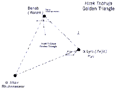 |
| Fig. 16 – The Diamond Triangle as seen in the sky, compared with the Golden Triangle of Orissan tourist sites. |
Aberrations
- No monument is traceable for the bright star Capella, although a new site has been theorised.
- The large monuments of Boital=Sisireswar and Basudev do not correspond with any bright stars.
- Small disparities in the locations of stars 2, 3, 4, and 24 and their corresponding monuments have been noted. This may be due to effects of precession or the polar view zenithal projection of our star map.
- The fort correlating with star 11 seems too far out of the core zone to match the actual distance of the star from Rudra (although the angle is correct). The presence of a better but buried correlating site is theorised, at the same angle relative to Parasurameswar but closer to it.
- In view of obstruction of the sky-line by modern buildings, angular measurement of only visible sites were taken.
Expectations
If pictures of the night-sky over Bhubaneswar at some point in the past (e.g. 2000 years ago) could be superimposed with satellite images of the Tarakka area centred on the Parasurameswar temple, we expect this would reveal a number of other things.
- A closer geometric correspondence than that shown above.
- Points of correlation between ground and sky that we have not yet detected – including unexcavated sites.
- A date at which the correlation is best.
We also think that simulation of changes in the stars over India due to precession may help to explain gradual shifts in architectural activity (which we think may possibly mirror the precession of Orion), and may also shed light on the twists and turns in the Hindu epics as well as features of the chitra bhasa (story-telling sculpture) on the astronomically-inspired temples of Bhubaneswar.
Other Sites
The Pashimeswar group of monuments near the town of Boudh in central Orissa contains four star-shaped monuments with star-shaped Shakti-Lingas dating to the 10th Century AD, which match the shape of Orion. Other monument groups in India, which seem to demonstrate similar astronomical reflections are listed in table 7 below.
| Table – 7 | ||
|---|---|---|
| Monuments | Place | Possible Cellestial correspondence |
| Pasupatinath | Kathamandu | Aldebaran |
| Martand | Kashmir | Sun |
| Somnath | Pattan (Gujrat) | Betelgeuse & Ekadasa Rudra |
| Ellora* | Maharastra | Bellatrix |
| Pattadakal, Halebid, Bellur, Sutrapada, Saraswati temple (gada) etc. | Karnataka | Orion & Individual Stars |
| Chidambaram* | ||
| Kailasnath | ||
| Brihadeswar* | Tamilnadu | do |
| Minakshi | Anirudha & Chitralekha ? | |
| Srirangam* | ||
| Gopurams* | South India | Similarity with Inca type. |
| Simanchalam* | Andhra | Rudra |
| Kamakshi | Assam | Moon |
- The panchayatan system has close resemblence with Orion.
- Above are only a token list. Astral trace in archeaology is not limited to Ekamra
* Site visited by authors.
Conclusion
As to the question of whether ancient Kalingan architects were influenced by Vedic ideas, the answers seems to be more complex than a simple yes or no. All the monuments detailed above enshrine Saivic icons and anicons, which are held as non-Vedic in origin (their origin is considered much earlier). However, the cosmic aspect of the Linga anicon indicates a possible convergence of Vedic (abstract) concepts with earlier practice. In other words, the astronomy reflected in the stone archaeology can be traced back even beyond the Vedic literature, even though the archaeology as it stands today is actually post-Vedic.
As to the question of whether astronomy affected the positioning and design of Bhubaneswar’s temples, the answer is affirmative. We have found a multimode relationships between the celestial and terrestrial Tarakkas. This practice also seems to have existed across the Bay and elsewhere in India.
It is apparent that astronomy is a useful research tool in the science and practice of Hindu archaeology.
Acknowledgements
Interphasing and interacting the celestial scan with terrestrial zone may not have been possible for virtual realisation but for the gracious assistance of Er. S. Pattnaik and the especially skillful Er. J. P. Mahanto of Eastend infotech, Bayan Bhavan , Bhubaneswar. Free of charge they computed the data and generated near-virtual imagery using 3D software – for the first time this has been done in the sub-continent. Thanks also to: Dr. Bhagwan Panda, Secretary of the Kedarnath Gabesana Pratisthan, for assisting with the Lexicons, Purana references and Sanskrit translations, to Dr. P. K. Kar, Head of the Geography Dept. at Utkal University, for lending his theodolite, to Dr. D. Behera, senior scienctist of PCB, and Mr. P. K. Dikhit, Assistant Archaeologist at the A.S.I Excavation Division for helping with the theodolite experiment, to Mr. Lingaraj Maharana, Mr. T. B. Sahoo, Sudhir Kar and D. B. Mishra for helping with the computer graphics and laser typing, to Mr. Debaraj Pradhan, Secretary of Maritime and SE Asian Studies and Sri Manmath Samal, Librarian, at the Orissa State Museum for valuable references. , to temple sebayats for physical help and measurements. The entire work done on a voluntary basis, financed by Smt Mamata Bhattacharya .
References
- Prof.K.C.Panigrahi – Archaeological remains at Bhubaneswar – 2nd Ed.1981,pp.
- Prof.T.E.Donalandson – Hindu temple art of Orissa – 1985, Lieden pp – 51-63.
- Moti Chandra – Trade & Trade Routes in Ancient India; Abhinava publication, New Dellhi 16-pp 144.
- Pandya, Dikshit, Kansara ,Issues in Vedic astronomy & astrology ; Proceedings colloquim on vedic astronomy & astrology 26.28 Sep/89.Nagpur.ISBN.81 208.1089.9, pp.101.339.
- R.P. Mohapatra , Archaeology in Orissa , Vol-1986, pp 19 +54,55.
- T.Gopinath Rao ,Elements of Hindu Iconography, New york 1968, 2nd Ed. Vol.II part II. Pp-474.
- Sabda-Kalpadruma . Chowakhamba sanskrit series, work No.93, part II.1961 pp.450.
- Bhattacharya et.all. The Magnificiant Monument of Sri Parasurameswar ISBN . 81.90559.0.4.( under print )
- Rastogi & Merhotra. Compendium of Indian Medicinal plants, Vol.II.CDRI, CSIR publication . 1970.79.pp.530.
- W.M.Smart, Text-Book on shperical Astronomy, Cambridge University press , 1947.pp.25-27.
- D.Arkasomayaji, Commentary to Siddhanta Siromani of Bhaskaracharya, Kendriya Sanskrit Vidyapeetha, Tirupati, 1980.pp.393.
- B.Guha and A.Guha , Rigveda O Nakshatra, Calcutta -1967.
- Yale Catalogue of bright stara . 2000 A.D.
- V.Dehejia – Early stone temples of Orissa, vikas , 1979.pp.33.61 & pp.205.
- Prof,R.C, Majumdar, Survanadwipa . vol . I.1986.pp.6,17,30,31,33,39-87,180,181.
- K.S.Shukla, Aryabhatiya of Aryabhata, Indian National Science Academy, New Delhi – 1976.
- P.K.Mishra, Indian Journal of History of Science, 31(3), 1996-pp-281-289.
- Dr.S.K.Panda – Political & Cultural History of Orissa – ISBN-81-224-1197.5,1999.pp.62.
- Sunil Gupta. Archaeology of Indian Maritime Traditions : Early historic phase; man Environment XIX (1-2) . 1994.pp.217.225.
- Rear Admiral K.Sridharan AVSM. A Maritime history of India 1982.pp.1.38,GC Publication.
- Prof.H.B.Sircar . Corpus of Inscriptions of Java Vol.II.1972.
- Ananda Coomarswamy, History of Indian and Indonesian art. 1st Ed.1997.
- Marshall, Foucher, Majjumdar. Monuments of Sanchi.vol-II & III-ASI.
Footnotes:
- There is another ancient wall beneath Indira Ghandi park in the city, at the right angle and distance, which could be part of the fort that was originally meant to correlate with Pegasus Square.
- The Lothal dock measures 35.36m x 216m. The length of the Vela dock is similar, but its width is three times greater.