


By Deepak Bhattacharya 1 & P. C. Naik
Edited by Christopher F. Ash
Part I : Correlation with ancient Kalingan archaeology, Tradition and Legend
Abstract
The location and design of the ancient temples of Bhubaneswar have been guided by a rich astronomical insight. The positions of these structures correspond to the locations of stars. These stars may have served as a kind of “compass” for ancient mariners, and the cult that assigned to them significance may have followed their precessional movement in an overland migration back and forth over the indian sub-continant over a period of thousands of years.
Introduction
In the sub Puranas (Hindu ancient scripture) called Koiel(y) Purana, a forest by the name “Tarakka” is mentioned in the context of the first appearance of the Hindu super-deity, Lord Shiva, in his “Natraja” (“Lord of dance”) form.2 In our previous paper we discussed a geographical zone, Ekamra (or Bhubaneswar), the monuments of which, we suggest, have a one to one correspondence with as many as 37 bright stars. We have also suggested that smaller stars and whole constellations are reflected or recreated with monuments on the ground. Each component member monument bears a multi-mode relationship to the heavens, its architectural features also resembling stars (when a tangential (or “birds-eye-view”) perspective is taken of individual monuments, or the entire group or part thereof, they appear as fallen stars on the ground).
While we have elected to name the zone “Tarakka,” meaning “intra-star zone,” we have thus-far avoided linking Ekamra with that mythical forest of “Tarakka,” despite the term “Tarakka” being an apt description of our subject: it being a true “Forest of Stars.”
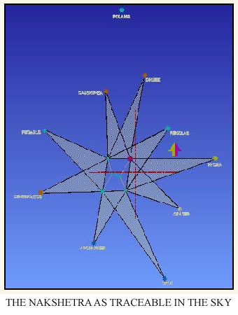
Examining the Tarakka geographic zone, we find that four constituent members form a rectangle at the center. There, the trapezium matches a terrestrial model of the Orion constellation. Taking only those temples which are relatively equidistant from any two of Orion’s terrestrial constituents and joining the three buildings with straight lines to form a tapered triangle produces a nine-pointed-star known as Nakshetra (“nine zones”). Incredibly, this Nakshetra is also perfectly traceable in the sky . There, the geometry offers a wealth of complementary angles and pointers — or possibly even direction indicators.
The Vedic terms “Nakshetra” and “Tarakka” both mean “Star” (“Tara”). It is our position that the study of Tarakka / Nakshetra was among the primary scholastic activities of a bygone civilization that conceived this nomenclature. Our study indicates that such a school of ancient astronomy as may have existed, amalgamated zenithal and azimuthal components and coordinates (as do modern astronomers) in direction-finding, and incorporated into its scheme very bright stars from both hemispheres while excluding the poles. The Nakshetra-type direction indicators also exclude the north Pole-star and thus likely predates the Common Era (1 AD, when Polaris occupied the north celestial Pole). If Nakshetra is part of Tarakka, and Tarakka is part of Bhubaneswar, such an ancient astronomical “school” may have been located at this site.
Theoretically, the Nakshetra may have had a practical application as a route-finder for ocean navigators of that bygone civilization, such that they would have been at ease sailing in either hemisphere; something as yet unreported from any other civilization.
Our Position:
- The nomenclature Nakshetra, in terms of antiquity, is Vedic.
- This Geometric configuration of Nakshetra, when at zenith, can function as an excellent direction-finder both on land or on the high seas. It is also eerily close to the modern, eight-pointed navigation compass. [We think it possible that in later times, the rectangular perimeter of the Orion constellation may have been reduced to a square and the nine direction pointers reduced to eight; the celestial-inspired format ultimately forming the basis of a simple instrument: the mariners compass.]
- While Tarakka has been identified by us with Bhubaneswar, Nakshetra remains a part of it.
- The culture that exists today in the Tarakka zone posseses a rich tradition and claims an equally rich heritage, including religio-socio-cultural practices associated with sea voyage and with the ancient archaeology of this very zone. They are not nomadic today and neither are they reported to have had a emigrated into the area at any time in the past.
- Interestingly, we have been able to locate, study and investigate a series of archaeological items from the area useful in Azimuth, declination and direction computing.These artfacts include astrolabes, compass, mariners wheels / sail-set-wheels, looking devices, time-measuring instruments, clear sky diurnal and nocturnal use versatile devices, and more.
- The history of the past 500 years are said to mark the “dark age” of this area and its people.
Miscellaneous socio-religious aspects associated with Nakshetra
During the monsoon season of June to September, such a celestial Nakshetra (nine-pointed compass) – with the Orion constellation at its center – would not be visible from the territories of Kalinga, neither from the better-part of the Indian sub-continent (with the exception of Kailash mt./the Himalayas, Tibet, etc.) including the bays of the Indian Ocean. This means that, for four months out of the year, the celestial signature of the Lord is covered by the heavy and all pervading monsoon clouds which are 10 to 30 Km thick (Orion, as we have presented in our previous communications, was and yet remains in Hindu culture, synonymous with Rudra/Lord Shiva).
All over India, this period is known as Shiva Jala abhiseka; and is marked by devotees by the carrying of pristine and holy waters to Shiva temples. Interestingly however, this abhiseka is not observed at the ancient site of Parasurameshwar nor at Lingaraj, the two principal living shiva temples at Bhubaneswar/Ekamra (the heart of TARAKKA/Nakshetra and erstwhile capital of Kalinga). These two sites form the northeast and northwest corners of the earthly model of Orion, “Tarakka.”
Furthermore, at these sites, this period is refered to a the “Chaturmasia” period, during which the ruling deity, Lord Lingaraj (which we identify with b Orion) is said to fall sick and take to bed. But before He takes to bed, along with the minister (Kapilnath), He visits Parasurameshwara (idendified by us with a Orion) and, with humble words, hands over the reins of the city and empire to Parasurameshwara (a Orionis / Rudra / Betelgeuse of Tarakka). This temporary exchange of tenure ends with the clearing of the sky and the onset of fair weather. The annual period of divine “bed rest” is prominently marked in the Oriya calendar as Shiva Sayan and Shiva Uthapana chaturdasi respectively. Both these dates would be very important to sea voyagers, for whom clear sky and fair weather mean good sailing conditions.
On the day prior to every new moon and full moon on the Hindu Lunar calendar, a day known as “chaturdasis,” a person belonging to the Khandait (“warrior”) clan, having the surname of Samartha (“capable”), climbs to the top of the 180ft high monument (which we associate with b Orion) and holds aloft to the sky, a flaming torch (“maha deepa”).
To whom is this torch held aloft? Is it to the Vedic Jagya soma, known as “Puaranic Kalapurusha,” “Orion,” “Rudra” and “Adra” (meaning “red hot”)?
This ceremony raises a number of interesting questions.
First, why are the reigns of the city handed over with “humble words?” It seems passing strange that a living deity, with full royal appendages, enshrined in a 180ft-high, imposing, ornate monument, should make a pilgrimage to the home of a lesser deity, housed in a 45ft-high, comparatively small monument.
According to Hindu mythology, Parasuram is Rudra. Rudra, according to ancient Hindu astronomy (“siddhanta”) is identified with a Orionis, a variable, “red hot” star of magnitude 1, and a very ancient star as well. As for the deity and monument of Lingaraj, it represents b Orionis, which is a smaller and newer star. These correlations seem to indicate that the ancients of this place had the benefit of some measure of “advanced” Astronomy. How are such relationships to be explained otherwise? [Note: we do not intend to suggest that astronomy in any form or manner originally evolved here.]
When, in all of India and parts of Kalinga, it is the time of Shiva jala abhiseka, why is this said to be the “sickness” or “sleeping” period for the supreme deity in the supreme monument (a 180ft-high Lingaraj temple, where the deity takes jala abhiseka from every devotee as his – Lords – most preferred means of devotional worship – that is, on all other days save Chaturmasia)?
To us, this is an indication that the Kalingans, being master mariners, and thus heavily dependant on professional navigators, helmsman and traders (Kalingans also possessed a kingdom across the Bay of Bengal3) may have interpreted the monsoon cloud-cover phenomenon as a period of illness for the lord. After all, along with it came his off-season, as the better part of Kalinga witnesses heavy, incessant rains, floods, cyclones, and very rough seas, as well as tragedies and woes of both a personal and communal nature. Moreover, during this season of flood and water, all shiva lingas out in the open and in the flood plains in river valleys would get a drowning drench, with the exception of the shiva linga of Lingaraj, or any one that might be on a watershed like the Parasurameswar temple.4
Another question inspired by the divine visit to Parasurameshwara is why such a ritualistic annual passing of ecclesiastical reins even occurs?
Might it simply be because the monument of Parasuram is the terrestrial abode of a Orionis / Rudra (meaning “red hot / terrific aspect of Shiva”) and predates the shrine of Lingaraj – the former possibly being the earliest original Hindu royal monument? The art on the extant monument of Parasurameshwar is dedicated to a resurgence of Hinduism over Buddhism; a resurgence that swept the sub-continent between 2nd century BC and 2nd century AD. The Chitra Bhasa (story telling via art) on Lingaraj monument is very different indeed and dates from the 11th century A.D. This also provides evidence of the continuity of ancient practices and traditions.
Why a season for Jal abhiseka? Well, ancient astronomy or stargazing was certainly not limited to Kalinga, and we do not suggest that it originated here. In the uplands of the sub-continent, Shiva lingas were exposed to seasonal monsoon rain, during which the overhead Orion, which was the heavenly Shiva, was not visible. The ancient faithful might have concluded that, as the heavenly Shiva takes a cloud cover, it is time to pour water on his earthly signatures.
The Kalingans, in contrast, may have observed and understood Orion as a divine guiding force, permanent, fixed and all pervasive: as it could be seen and relied upon for guidance from unknown places in any hemisphere and, in the absence of which, mariners might lose their way. Residents therefore may have chosen a royal seat, appendages, paraphernalia and high ground for the a / b Orion’s terrestrial signature (Shiva linga) and may have desisted from pouring water during the season of rain – instead, introducing the cult of the annual “sickness” period.
Yet the Kalingans went one step further and developed a versatile compass-like device, augmented it with direction indicators, and unabiguously associated this device with Lord Siva. Such an act could have been an acknowledgement of the gift of lord Shiva / Kalapurusha mandala – otherwise known as the Orion constellation. In separate communication, we have produced archaeological evidence for this versatile compass, referred to as Yantra ( “instrument” ), in maritime treatise.5 The Kalingans ( Oriyas – exclusively ) went on with additions and alterations in the scheme of the Yantra and have left for us a series: the Nakshetra remaining the fulcrum of the scheme.
In a subsequent paper, we demonstrate that the Shiva Linga is an iconic model of cosmic and engineering parameters. These are all artifacts of astronomical observation and highly suggestive of computing abilities. The compass is the much-valued product of its practical application. What we suggest is that the ancient Kalingans possibly made the compass synonymous with Kalapurusha and wove life around it and with it – as we see in Tarakka, Nakshetra, “The cranium,” and others.
Celestial aspects of the Nakshetra
The point at which the celestial equator and the ecliptic intersect with the star a Ori at its zenith is an interesting location in the night-sky and, when such a coincidence occurs, it offers a celestial spectacle.
At some point of time in the past…
{ i } Rudra, that is, “Betelgeuse” or “a Ori“, could have been aligned on a local latitude, along with the intersection of the ecliptic, offering a very, very rare seasonal celestial spectacle in the night sky. This visible alignment (static Orion, with or without ecliptic) would have occurred for the longest period (approximately 5000 to 6000 years) at latitude 20 degrees north, which is the approximate latitude of the Tropic of Cancer [from +18 degrees to +23.5 and back until +18 is reached, i.e. 10 or 11 degrees in precession in 5500 / 6000 years]. This period would certainly have been long enough for the phenomena to act as a long-lasting celestial guide, and form the cultural inspiration for the identified monuments and rituals.
{ ii } This phenomenon occurs only prior to the advent of the Common Era. When we move to 1 AD, or to the 1st century B.C., we note that a Ori achieves a much lower declination, and the above-discussed seasonal alignment (to the naked eye observer) is no longer feasible at zenithal position on latitude +20 degrees.
Oddly, the mention of Nataraja’s prior and first appearance in the forest of TARAKKA ( Mahanadi / Prachi basin ) can be justified if we consider the Puranic version as a valid report of past celestial happenings; this would date such a 1st appearance to Orion’s previous precession cycle, roughly 31,000 to 25,000 years ago!
{ iii } This same alignment occurs again on the equator or, more importantly (from the Indian, sub-continental angle) on latitude 10 degrees north – which is the location of the Chidambaram / Kaveri basin and Deccan plateau (the intersecting point of the ecliptic and a Ori ). The phenomena would have been visible here for approx 1000 to 2000 years only. All these might have inspired the ancient observer to note it as “the center of Universe.”2 5
However, it is possible that this precession of Orion (which is associated only with Lord Shiva) may have also caused the migration of the faithful – within the tropics – possibly explaining the extensive spatial distribution of Shiva Lingas and Shiva temples within the tropics.
The 1st appearance at Chidambaram ( Kaveri Valley ), or alignment with latitude +10 degrees, is ascribable to Orions’s previous precession into Northern hemisphere ( return from the south ), which occurred between 28,000 and 36000 years ago. The 2nd appearance coincides with Orion’s return back to southern latitudes, datable to 21000 to 19000 B C or 21000 to 23000 years ago. The 3rd apearance occured between 2000 and 3000 years ago, between 1000 B.C. and 1000 A D, which is the current cycle.
Archaeological evidence has been recovered at the +10 degree latitude of southern India. This doesn not indicate a prima facie terrestrial Tarakka. Ground surveys and submarine archaeology are still required to clear the issue, but we believe the possibility is good that a south-Indian Tarakka exists. The antiquity of sites of any such terrestrial TARAKKA will then have great relationship with the textual term of “1st appearance” and go some waytoward authenticating the authority of the texts. Traditions as current at Chidambaram however push the date of the shrine to eons past. Iconographically, the enshrined deity at Chidambaram is directly dedicated to Nataraj and relates to alpha Orionis.
Comparing the major extant ancient Nataraj sculptures of India , the present Chidambaram variety incorporates many features that are well developed from angle of iconography, considered late by historians. Whereas it is all abstract symbols that have been enshrined at Ekamra ( Bhubaneswar ).
That Orion’s up-and-down precession may have lead the faithful of such a school to become accordingly spatially separated is amply supported by the prevalence of orthodox Shiva linga worshippers over the Godavari / Narmada – Saurastra belt of the Deccan plateau in the Indian sub-continent. It may be relevant to note that the Lingayats even today wear in pendants around their necks, or stuck with sacred thread, a small model (mostly made of Gold Or Silver) of Shiva Linga, “Orion’s signature.” Saurastra infact offers the Orion concept on Ground, not Tarakka, neither Nakshetra.
Further study may indicate that Vedicism may have been synonymous with Orionism, later known as, and identified with Shaivism: a school of thought possibly 100% indigenous to the geographical belt on the Indian mainland, south of the 23rd parallel ( Vindhyachal to Satpura valley / tropic of Cancer). In short, it corroborates the view that none of these philosophies or ways-of-life are imports.
{ iv } The southern archaeology of the cognate group, however, is in contrast with the ancient seat of Kalinga ( our other paper ).
{ v } The very fact that the Chidambaram tradition refers to the happenings in the forest of TARAKKA as the 1st instance, and repeated only then on +10 latitude, underscores the following important possible positions (apart many more permutations):
a ] Astral alignment over the equator is discounted as it was unlikely to have been observed in any way capable of influencing life or thought on the Indian sub-continent + 20 latitude; although this may have happened twice in one precession cycle of Orion. Nevertheless, we find such a precession cycle may have drawn saivaits into S.E. Asian archipelago i.e. they seemed to have followed Orion back and forth .
b ] That post 29,000 B C (i.e after Nataraja’s appearance in TARAKKA zone [ 1st appearance]), Orion must have precessed past latitude +10 in its southward precession path only few thousand years later ( around 21000 – 19000 B C ) . This aspect remains obscure as it is not referred to by that very learned society who took ample care to refer to TARAKKA and the 1st instance. This may mean that the Kaveri basin was devoid of any sizable civilization, or that what civilization was present did not identify itself with Orion at the time, as it did later OR it indeed means 21000 – 19000 B C period 7. We are not out to invent history; we are only intent upon the consideration of collateral matters .
c ] That the 2nd observation was noted and termed *the centre of the universe* ( irrespective of date ) also indicates the possible fact that the ability and practice to note in script had by such time evolved, in contrast to the time of the previous appearance ! The various Puranas (ancient religious / mythological texts) that talk about NATARAJA / such astral phenomenon, are very late works, dated between 10th – 17 th A D 7 .
d ] That by such admission it is indicated that civilization identifying itself with Orion did exist in the Central and South ( Indian subcontinent ) ; which again means that existence of such Religio – Civil societies ( saivaits ) may have been a pan-Indian phenomenon, even in such remote times!
e ] While 2 dates are apparent for the 2nd appearance, the texts refer to only one instance; there is no such conflict in the case of 1st appearance .
f ] All this boils down to the possible fact that a section of the civilization was indeed avid star gazers and identified itself and its god with the constellation Orion, and possibly also migrated in reference to it. They are known as Saivaits. It may be relevant to context that Nataraja of Chidambaram is considered as the cosmic aspect of Lord Shiva and has special festivals relating it to Adra / Rudra2.
During the period 36,000 B.C. to 11,000 B.C., or till 8000 BC, the Himalayan Rivers were in glacial phase followed by a deluge phase (Govardhna episode) between 8000 B.C. and 5000 B.C. The banks may have been swept clean by this event. Hence the southern and highland sources and remains survived better.
[The Ekamra vrs Chidambaram comparison is based on the assumption that our identification of TARAKKA geographical zone holds good.
In separate material. Bhattacharya has produced archaeological evidence of Ananda Nataraja, as described in Upa and Sthala Purana (sub and local epics ).].
It is at that point of time ( above ( i ) ) that the tradition of Lord Siva ( Kala Purusha / Orion ) appearing in his cosmic form in the center of the universe, and performing the Ananda Nataraja ( The joyful dancing Lord ? ),6 may have taken genesis in the minds of the faithful. At that point of time (above ( i )) the scheme of Nakshetra settles as a square peg in a square hole ( as does TARAKKA ). The location of the archaeology of the as-yet buried monument of Bhavani Shankar ( Aniruddha e Ori ) indicates good geometric consonance in the scheme of monuments identified in this study as building members of the ground model of Orion but, as said, this monument has yet to be excavated.
(The name of this monument is Bhavani Sankar. It got buried by the earth ramp that was erected during the construction of the great spire of Lingaraj – beta Orionis. It faces North and offers interesting co-relation with astrals) .
Such a central position (i.e. the ancient concept of Nataraja appearing at the the centre of the Universe, preceded only by his previous appearance in the forest of Tarakka2) is computable to only above mentioned celestial timings and is very rare in the whole night sky (for either hemisphere). All other points of intersection are meaningless without Orion (at zenith and a river valley beneath).
In 2002 AD, b Orionis is yet to cross the equator ( whereas a Orionis, being Rudra /Shiva, the focus could not have been any other astral body ), a spectacular phenomenon where planets could be seen coinciding and passing right over Betelgeuse / Shiva / Rudra / the then supreme divinity. Visibility of such a rare celestial spectacle could again have been limited by nocturnal hours, the season (position of ecliptic) and a clear sky (non-cloudy). It may also be for such reasons (profound effect on the faithful mind) that we find Orion to have been fully copied on the ground and forming the hub of the Nakshetra, while a Orionis forms the hub of TARAKKA.
TARAKKA could possibly be the replication of that very picture (above ( i ) ) and that rare celestial phenomena as observed by the ancients. Tarakka was celestially inspired, each part being the part of the other. Tarakka and Nakshetra can be swapped.
When was Alpha Orion on Zenith at Latitude +20 degrees? And for How Long?
As for Orion’s present position on +7 degrees latitude (as of AD 2000 [ 2100 AD max declination is achieved ]), as the solstices migrate to their December position (Capricorn), a Orionis has an excellent chance of being visually aligned with Orion on latitude +20 degrees during the winter season of the Northern Hemisphere (seasonally). At present, alpha Orion is marginally south from Zenith at Midnight, as observed from December to January 2002 with the naked eye from local latitude. This remaining angle will be closed over the next 100 years. Thereafter, Orion will steadily fall south.
We have asked many people (Astronomers and non astronomers) and they all agree that Orion is indeed very, very close to overhead. Some (especially the priest class) said it is already overhead! In fact, Orion rises much to the north of our locale and straddles the eastern horizon. At zenith, it gets squeezed which, in itself, indicates (naked eye science) that indeed the declination / altitude is at it maximum. Today, Orion takes a slight northeast off east to southwest of west trajectory.
Observation like this was the only tool available to the ancient astronomer-priest. The wobbling of the Globe and its 23.5 degree inclined axis, was certainly not known to them. Therefore, the observation path would likely have been their gross and net idea of the trajectory and location of Orion and all other astral bodies. They copied accordingly.
It works out thus: the precessional movement of Orion, from latitude +18 degrees to latitude +23.5 degrees and back, until latitude +18 was reached (i.e. +10 or +11 degrees), Orion was aligned with +20 degrees latitude (for the naked eye observer) on latitude +18 degrees to latitude 23.5 for between 5500 and 6000 years. It may have appeared in such alignment around 36,000 B.C. to 32,000 B C. and returned back, after visibly aligning with the Tropic of Cancer and the ecliptic ( above ( i )).
Such apparent alignment may have been visible over the whole of the Indian sub- continent a few thousand years prior to 36000 – 32,000 BC, until approx. 10,000 BC,where after it precessed out towards the south and the sea (below latitude +8 degrees), an area recognized today as pitris or Pitriloka (home of ancestors of the Hindus) and to where the soul is said to return! Pitris, it may be noted, roughly coincides with the southern-most point of Orion’s precessional path, that is, the Indian Ocean.8
Pitris or Pitrilaoka is a mythic & Vedic concept considered by the Hindus as the celestial abode of the soul post demise . The Hindus offer oblation ( called Tarpan ) to the soul of the deceased parents & grand parents by sitting beside a water body , facing south !
Pitris is also identified by Hindu astronomy as Siddhanta.8
Nakshetra and Tarakka and Vedic Time
We have earlier opined that Rik Veda is a concise ode to the Cosmos, in limited diction, composite words, in the present, continuous tense. It is established that the geography of the Rik Veda centers around Jagya Soma (kalapurusha / Shiva / Orion of later times).
What the findings outlined in this paper seem to indicate is that this very constellation, in its previous cycle, was visually aligned over latitude +8 degrees (India’s southern tip) between 36,000 B.C. and 10,000 B C, that it moved in from the south (sea), visibly went up to central India (Vindhyachal – Satpura valley / tropic of Cancer) and returned. We suggest possibly that the very stargazing society that wove its life around such a constellation may have taken on a similar migration path! If this civilization be called Vedic, its historical terminus may coincide with the above dates and its movement follow the same route from south India and back. If so, this civilization and its belief systems are likely 100% indigenous.
At this point it is difficult to comprehend intelligent and articulate human life beyond 36,000 B.C. With such a paradigm, however, it is equally difficult to comprehend Vedic culture to have descended from the northern latitudes or Hindukush.
What is relevant to the context is that such a star-gazing society could have migrated with the Kalapurash. Thus Kalapurusha ( Orion ) became a celestial guide, initially on land and then on sea .
Over sea, the distances were not only far greater but also far in-between, direct sailing being not possible ( the vessel had to remain close to shore ) a radiating pattern was traced in the sky ; i.e. our Nakshetra .
Associated Mythology, if Any
According to the mythology associated with Nataraja at Chidambaram (Tamil Nadu, latitude +10 degrees), Nataraja appeared there for a second time. It’s first appearance was in the forest of Tarakka.2 If the location pattern of shaivic sites at Bhubhaneswar (Ekamra) can be accepted as the forest of TARAKKA, to the exclusion of all alternatives (no other being available or offering so much similarity in the whole of the Indian subcontinent and elsewhere) It follows that our NAKSHETRA or TARAKKA’s foundation in mind (and perhaps as well in embryonic physical form) may have been between 29000 BC and 23000 BC – that is, the previous precession cycle of Orion!
The 2nd appearance of Orion at latitude +10 degrees (Chidambaram / Nataraja Monument) correlates well, as we calculate that a Orionis crossed it or crossed the Kaveri basin just a few thousand years ago! Certainly no people were better-positioned to enjoy, and be influenced by, the spectacular celestial phenomenon described in the body of this paper than those living between latitude +20 degrees and latitude +10 degrees (right below the zenith position of Orion). Might those living at this latitude have been sufficiently inspired to reflect the constellation on the ground in architecture?
Part II: A Voyage to the Orient
The theoretical point of the celestial intersection [the “centre of Universe” or 2nd appearance] can be identified in the NAKSHETRA diagram. The constituent stars of Nakshetra are as in the table below.

| W – West face monument E – East NK – Not Known SW – Southwest |
The four corners of Orion are 12. Bellatrix (Uttareswara) 15. Betelguese (Prasurameswara); 17. Rigel (Lingaraj); 20. Saiph (Dakara Vivishana) a- Usha (Bimaleswar) b- Anirudha (Bhabanishankar) c- Chitralekha (Mohini) |
||||||||||||||||||||||||||||||||||||||||
North/Polestar has not been considered |
|||||||||||||||||||||||||||||||||||||||||
Why the Kalingan Sailor and not some one else?
We have noted that Orion was visually aligned over the Kalingan territories for the longest period of time, in contrast to other places in the Indian sub continent. Natives of this region thus had the means to dare out to sea and home again with the navigational aid of the constellation. This practice must have taken a slow evolutionary route. While its studious aspect may have come much later; practice preceded. Time and tide were with the ancient Kalingan sailor (seasonal fair weather with a long coastal belt; across the bay, another land; none of these influences are available in India’s southern tip, which has a vast endless ocean). Comparative archaeology throughout India indicates that he also enjoyed royal and social patronage as well.
As the ancient Kalingan sailor set sail from Kartika Purnimaa (under the full moon of November) he might have trusted in this celestial compass, or its hub (Orion), which in Vedic terms is “Jagya Soma” and in post Vedic and Siddhantic terms is “Kalapurasha / Rudra / Shiva.” This may possibly explain why every evening, even now, the Oriya household holds a burning oil lamp to the night sky during the month of Kartika (October to November, we believe would have been the best time to have set sail). This practice is apart from the fortnightly hoisting of Masala / Maha deepa (the previously mentioned “flaming torch”) atop the Lingaraj spire on every Chaturdasi.
Might we suggest that the spire itself may have acted as an additional signpost for the mariner, in daylight? Moreover, post sunset, the burning lamp may have played a role similar to that of a modern lighthouse. Might Chaturdasi have been an important date for navigation to and from the harbors?
In fact, coastal and deltaic hydrology supports this conclusion.
This argument, we deal with in our paper Balijatra (Sojourn to Bali Island), where we also try to peer through the demographic maze and locate the descendants of that ancient maritime class. It may be relevant to remind the reader that in our paper “The Cranium…” we have sought to portray the spire as a model of an ancient observatory. It may also be noteworthy that numbers of stars and constellations bear Indian names.
It was to the care of Kalingan sailors that Emperor Ashoka, post Dhauli (3rd century B.C) chose to entrust his only daughter in her voyage to Sri Lanka. Perhaps these professionals were indispensable even to the mighty all-conquering emperor.
Time of Rik Vedic and Nakshetra Civilisation
The time period between 36,000 B.C. and 10,000 B.C. mentioned above, if called the Rik and post-Rik Vedic, is fully consistent with the time of Nakshetra. It is indeed possible then that the two civilizations existed in parallel. A possibly more-articulate Panini / vedic culture may have derided the other but what harm the Kalingans may have done Panini,10 to his times and his civilisation, remains untraceable and presumably unreported.
Kalingans and Rik Vedic Culture
It was Panini, the grammarian of yore, who opined, “Mlechha desa Kalinga.” Assuming he was not parochial or biased for reasons unknown, his opinion is in consort with our own view; that Kalingans were maritime professionals who made their living on the water as fishermen or boatmen – hence “Mlecchas.”
When it comes to maritime nomenclature, it is abundantly clear that the terms that have stuck are uniquely Kalingan in origin. For example, the Yantra (pronounced as “Jantra”) never once is mentioned as Tara Yantra or Nakshetra Yantra. Similarly, Rik’s internal evidence indicates no Kalingan terms.
Whatever the explanation, we give selective mention to all these corroborative historical and literary, peripheral items, merely to make this paper holistic. This is an interesting area but one where information is difficult to distill from the various travel treaties and oral traditions. Great expertise in philology and literature is required.
As for the term Nakshetra, it is indeed mentioned in the Rik Veda but, while this paper applies the term to refer to the nine zones, the Rik means, and exclusively uses the term to denote, “Star” (tara) — not “nine zones.”10In fact, the Rik does not have any term for “Constellation.” Its characterization of the members of the night revolves around Tara.
Was the inspiration “pre,” “post,” or concurrent-with, the Vedic civilization? What of the evolution of the nomenclature? Whatever it is, Tara and Nakshetra seem inseparable; the Yantra, like Rik’s Tara, indeed stands apart. The terms cannot be amalgamated or swapped.
Prima facie it appears that Kalingan civilization, if at all, was separate and had little to do with Vedic culture. It had its own terms and phrases. One lived off the land and the other off the water. Did this mean there was no conflict between each culture and that both might have thus survived? Perhaps.
Methodology of Use of Nakshetra
The apparent shift of the Sun on the ecliptic is accompanied by an obvous change of season. These changes are commemorated on the local lunar and religious festival calendars. While the ecliptic migrates by 47 degrees, Orion shifts very little. This then ensures exclusive time zones when apparent (naked-eye observation) alignment of the ecliptic and Orion can happen. In fact, approximately 100 years from now, such an alignment is to happen on latitude +20 degrees (Bhubaneswar / Ekamra).
The ecliptic establishes a prominent east-west line, marked by the trajectory of the Sun at day, and by planets and the stars Regulus (alpha Leo) and Taurus (alpha tauri) at night (a fact relevant to day and night sailing). No such north-south line is available (in fact, the stars on the north and south horizons vanish and reappear seasonally with the shift in the ecliptic.
In the above diagram, we find no star in either the North or South that might mark a zone of the nine-pointed stellar Nakshetra. On the other hnd, the four corners (NE, NW, SW, and SE) are prominently marked by the following stars:
- a Urs majoris / Dhube / Kratu (declination etc)
- a Cass /Cassiopeia/ kasyapa
- a Hyd /Archarner / Nadimukha
- a and b Crux / S Crux / Trisanku
There are also stars marking out the zones (khetras) between these four stars.
This is of extraordinary value to a mariner on the high seas.
Any one pair of this four cornered guide, or embryonic compass, is located over the globe between latitude +60 degrees and lattitude -60 degrees. Each star pair was thus separated from its opposite pair by around 10 to 12 hour of arc (and there is a complimentarily of 60 and 70 degrees in angle as well). In either case the navigator is able to align any one corner-star of the Orion Trapezium with another, far beyond, thus marking a zone/khetra. As he voyages across the equator, from north to south, the northern pair falls toward the horizon while the southern pair rises in declination. The opposite is true for a voyage from south to north.
Assuming the sailor’s point of demarcation and destination were aligned with (and identified with) prominent stars / khetras; he could home-in on that center of Orion that is approximated with the Indian subcontinent (more precisely Ekamra Or the mouth of river Prachi) from as far as latitude -60 and latitude +60. In other words, he could sail out to peripheral zones of the Nakshetra with the onset of winter in the northern hemisphere, and return with the summer solstices. Conversely, he could march out on land with the onset of spring (coastal belt) and return with northern winter (all dictated by fair weather).
Using a model of the star-earth correlation carried aboard-ship, the seasoned and well-groomed mariner could crisscross the seas, stick to track, revert back to track in case of inclement weather, and maintain schedules, simply by fixing the point of start in reference to destination and adopt a simple, linear interpolating technique (as one discussed above). There may have indeed been a subsequent step, culminating in its celebration in stone art as the crowning piece of achievement.
Nakshetra is nothing but a theoretical, celestial intra-star that may have acted as a guide for the ancient unknown mariner. Later, it may have inspired a copy by the more able or the then learned men; of course backed by heritage and patronage – a conjecture supported by local archaeology.
Each Star, marked a particular Khetra, also marked a destination or geographical landmark. Thus the sailor had more than one star by which to steer his ship – he had a stellar instrument. He called this instrument the Yantra11 and is said to have taken “great care not to allow anyone to touch it….” (milinda prasna).
Kalingan Archaeology ; Nomenclatures and Culture
The whole scheme of such a “compass” represents an entirely novel method of computing direction; one that possibly only the Kalingans proudly maintained and commemorated in durable plastic throughout their building phase. Regally termed, “Dikpalas,” (“maintainer of directions”), it predated by around 500 to1000 years the latter “Khetrapalas” (“maintainer of zones”) which was commemorated in stone art.13
Later, these terms were conjoined as “Dikpalas Khetrapalas,” which marked out the eight directions (The Cranium). While Dikpalas are coincident with stars in our Nakshetra diagram; Khetrapalas do not demonstrate such a prominent, correlation with the astral bodies on the said diagram. It may be argued that by the time the later concept came into vogue the astral positions had possibly changed…
Or was it, perhaps, a changed astral position that called for new positioning and new nomenclatures? We think it was.
Khetrapala was an evolutionary step from a four-cornered compass to an eight-pointed compass – by all Saivic signatures. If anything went above Dik and Khetra-palas it was the various elements of the compass, topped by the insignia of the Lord at the pinnacle. The stone art only celebrates and commemorates those revolutionary evolutionary changes represented as a series.
The culture offers corroborative artifacts in the language, as well as in the rich and vibrant kimbadanti (“legends”) of high sea sailing popular in the area. Among these artifacts are the Boita bandana (The Ode to Sailor’s), Kartika Purnima and the Bali Jatra festival (annual boat worship, model sailing and month long festival on river banks), as well as another month-long festival (which preceded it at the height of monsoon), Khudurkuni Osa (whence the sister offers weekly prayers for the safe return of her sailor brother). Added to this are many Oriya terms in the trade treaties.
Does all this truly lead us to present day Orissa? The practices are exclusive to this region so the conclusion seems obvious.
From this paper it appears that the Kalingans may have sailed and traveled with reference to Orion, sailing in and out via the river Prachi. Their capital city has been identified as the zone of intra-star, also known as “TARAKKA,” the hub of which is a Orion. Their inland river dock has one to one correspondence with the constellation Vela (meaning “flotilla” in the native language). All in all, Orion appears to have a unique relationship with that hub of heritage that is the erstwhile Kalinga!
Furthermore, the natives here are called Odiyas, they speak a dialect called Odiya / Oriya, their staple diet is Oryza sativa linn (rice) — with it, they prepare a royal dish called Oriya — and their native land was called Odra in ancient times (apart from being called Kalinga / Tosala / Kosala, etc.) and as Orissa in present times.
Now, shall we also then conclude that the very word “Orient” is itself derivative of “Orion?” In the context of the renaissance, when the term was coined, Orissa, the land inhabited by Oriyas where life revolved around Orion, though it seems incredible, was “The Orient.”
This is the land where Kalapurusha mandala (the Orion Constellation) is or has been conceived as Linga (that which is pendant / dangling — as do the stars appear in pitch dark night). Traditional Indian grammar (sandhi) may settle the question thusly:
“Ka,” of “Kalapurusha,” plus “Linga,” of “Shiva Linga,” gives “Kalinga,” where Kalapurusha is worshipped in Linga form. “Kala” (“time”) plus “linga” (“icon” or “signature”), yields “Kalinga,” which identifies “the place where the signature of time is revered.” Kalapurusha: the ancestral home of the Hindus.
While we have firmly opined that the Shiva Linga is an icon of the cosmos assembled of composite elements of ancient engineering, in some way (archaeological models) it is also a wholly symbolic, three-dimensional representation of Orion’s Trapezium.
Possibly every time a merchant sailor safely returned from a sea voyage, attributing his safe return to the divine assistance of the celestial guide Orion, he erected a votive monument to Orion’s iconic symbol in gratitude. This would explain why we have such a profusion of small and tiny Shiva temples (perhaps in consort with the many pyramids in the Nile valley). Interestingly, we have all of them located beside navigable channels and, later, built around water bodies.
Apart from Orion is any other constellation a possible source?
Was there any other astral group that could have acted as a source of similar inspiration or as a celestial guide?
We do note that the constellation Chaya Agni (Cygnus), having a 10 to 12 hour gap with Orion, also offers a similar, four-directional cross. It was located at the pole around 17,000 B.C. and was visually aligned with latitude +20 degrees around 9000 B.C. to 12,000 B.C. and, prior to this, around 36,000 B.C to 35,000 B.C..
Chaya Agni (a cygni) is associated with the Vaishnava aspect of Hindu iconography and shares a one to one correspondence with the world heritage monument of Konarak (which is dedicated to Vaishnava, God Sun – Maitreyi and Chaya Devi). This monument bears, in stone archaeology, many characteristics of direction and time measuring devices.
At Bhubaneswar, around the site of b Orionis, are located a few deep, low-base monuments which may be connected (by imaginary lines) to form a similar pattern as that of the constellation Cygnus. e Cygnus appears as a conjunction of stars, its corresponding member monument is the deep-located, open-air, jointed Siva Lingas (only one specimen). The stars have a north to south orientation, and so too does the jointed Lingas! It is located just outside the precinct wall at the southeast corner of a Orionis (Lingaraj) site and is called Bappa O Maa (Father and Mother of Lingaraj).
Apart from this, It remains to be seen whether there could be any other better or similar source and format that might have provided inspiration.
Apart from the Kalingan, Any Other Race?
Possibly, yes.
In the archaeological models that we have studied, one other model presents some close affinity: the Vikings. The possibility of an intra-maritime race connection cannot be denied at this stage. The possible archaeological model of the Viking’s signature will be discussed in another paper.13
DISCUSSION
We present a scenario where the ancient Kalingans who, apart from having scholastic interest in astronomy were practicing maritime professionals, reduced the rectangular perimeter of Orion to a square and from the nine original conjoined stars, eventually reduced the number of directions to eight and, finally, used this celestial, zenithal-inspired format to compass the azimuth.
The archaeological model, as reported by us in *The Cranium…* is that of a versatile Yantra (instrument). The master-mariner of yore is reported to have resorted to the use of a Yantra for direction computing on the high seas;11 as the modern mariner uses the modern compass. Yantra, in fact, may be the forerunner of the modern mariner’s compass.
We find the celestial Nakshetra and Chaya Agni (Cygnus) as another very close possible source of inspiration for this Yantra or its predecessor. The cranium of the Kalingan temple spire may have replicated this model. Such a Yantra is indeed an eight-direction compass and it can also be used as a composite Sun, cum Star, cum Lunar-time measuring dial. In fact, it is a robust alternative school.
This being their highest and original achievement, they chose to place it atop the temple spires designed as the Cranium. Temple spires differ regionally within the territories of India and it is only the Kalingan school that exclusively presents such archaeology.
We in fact believe that, were a modern mariner to sail in reference to Orion and the Nakshetra, he would be better placed than by reference to the magnetic compass. With the Nakshetra, we are looking at an ancient “Global Positioning System.”
So it appears that the modern mariner’s compass had possibly a predecessor called Yantra, and that Yantra was Tara; alias “Star,” alias Nakshetra. All other items here-in mentioned above may be augmentative, corroborative, peripheral, or collateral; and have been considered and given only fleeting mention in service of an interdisciplinary and holistic approach to the topic.
That multi-mode relationship between cosmic Tarakka, Nakshetra and Kalapurusha, Chaya Agni was the possible inspiration for the compass AND Kalinga was the womb territory where advanced celestial navigation was conceived.
Acknowledgement
We acknowledge with gratitude the assistance provided by the able Er. J P Mahanta in designing the 3 D Nakshetra on Iron CAD and others like T B Sahoo for line drawings (coral); Librarian and assistants of Orissa state museum for timely and valuable references; Mrs. Mamata Bhattacharya for funding the research work.
Declaration
We do not intend to eulogize any community or Nation nor belittle any, neither suggest any sort of “revisionist” History. All materials are intended to be interpreted in a technical manner and with an objective perspective. The work is done on a voluntary basis and is funded by Mrs. Mamata Bhattacharya.
Footnotes:
- Indian National Trust for Art and Cultural Heritage
- T G Gopinath Rao; Elements of Hindu Iconography – N Y, 1968,2nded, Vol II-part- I; pp 236 and 237
- Sailendra empire of S E Asia ; R C Majumdar – Suvarnadwipa
- Parasurameshwara even 50 years ago marked one of the the local laterite bed watershed
- ICHR ( Indian Council of Historical Research – funded ) , 2001
- A Coomarswami ; Dance of Shiva – Sunrise Turn Inc, NY – 1924; pp 56 and 57 . In separate communication Bhattacharya has produced archaeological evidence of Ananda Nataraja as described in Upa and Sthala Purana (sub and local epics ).].
- The various mythic / religious / literary texts refer to the 2nd appearance as if it had occurred in the distanced past . They do not announce that it ‘ has happened here and now ‘ The grammar in neither in present continuous as in Rik Veda nor is the text a commentary on / of celestial happenings .
- Nadimukha is marked by a Siva monument on the north bank of the river Gandhabati, which is the river that presently connects Ekamra with the sea, via the great Chilika Lake. Prior to Nadimukha (“river mouth”) comes Matsyamukha (“fish in mouth”). Might Matsyamukha mark the place beyond which all those onboard a departing ocean vessel would have to depend on fish (no more exclusive vegetarian diet)? Interestingly one of the near-by settlement is called “Keuta sahi” (“fishermen’s hove”) to this day. Ketua sahi lies in between the monumental representative of b Orionis (Lingaraj) & Matsyamukha ( Kapileswar ). On the other hand, Nadimukha (“river mouth”) marks the treminal point of the river Gandhabati, which services the great inland dock of Vela. Vela is located two kilometers to the east of the representative of b Orionis (Lingaraj) == it is almost linear. Again, prima facie, it appears that the southwest corner Dikpala (“maintainer of direction”) of Lingaraj (180 foot high siva temple) seem to be in line with the representative of Nadimukha (Bhimeswar). This means the masala (maha deepa / “flaming torch”) could have been seen by a boat approaching from greater distance.
Both the archaeology members Matsyamukha & Nadimukha are ritually associated to this day with non Bramhin-Saivaits. Bramhinism has, in fact, taken over very few of the sites.
Nadimukha archaeology marks the termity of the Nakshatra scheme in this direction. Thereafter, it is low flat land which merges into the world’s largest brakish water lake, Chilika, which opens out into the sea. This could have been the mariner’s route.
- The Rik does not conceptualize Shiva nor Nataraja. This may indicate that the Rik period was coincident with Orion’s ascendance over sub continental latitudes and the evolution and spread of the Shiva – Nataraja concept was marked by the constellation’s descent. The southerners seek the character of Panini in the descent phase to Vedicanise Nataraja. It also supports our claim that the concept of Nataraja – Shiva (above) was present in the Tarakka forest and was not a creation of an Indian, Peninsular civilization. Does this then mean that Shiva – Nataraja was indigenous to the Tarakka zone? While Panini was a non-southerner and had not witnessed the 1st appearance of Nataraja – Shiva in the forest of Tarakka in his previous birth, and he is silent about why he did not visit the forest of TARAKKA…. .This all may indicate the two to be concurrent cultures – the TARAKKA civilization following the period of Orion’s ascendance.