


In his book The Orion Zone researcher Gary David shows that the constellation of Orion provides the template by which the Anasazi (the ancestral Hopi) determined the locations of their villages during a migration period across the southwest of the United States that lasted centuries. Spiritually mandated by a god the Hopi call Masau’u, this “terrestrial Orion” closely mirrors its celestial counterpart, with prehistoric “cities” corresponding to all the major stars in the constellation. By its specific orientation this sidereal pattern projected upon the Arizona desert also encodes various sunrise and sunset points of both summer and winter solstices. Surprisingly, the astral-tellurian configuration includes a number of contiguous constellations as well. Furthermore, the flux of ley line energy along a series of ancient pueblo sites and geoglyphs ranging from southwestern Colorado to the mouth of the Colorado River indicates the functional “chakra” system of Orion brought down to earth. In this article David gives us an overview of his main findings.
To watch Orion ascend from the eastern horizon and assume its dominant winter position at the meridian is a wondrous spectacle. Even more so, it is a startling epiphany to see this constellation rise out of the red dust of the high desert as a stellar configuration of Anasazi cities built from the mid-eleventh through the end of the thirteenth century. The sky looks downward to find its image made manifest in the earth; the earth gazes upward, reflecting on the unification of terrestrial and celestial.
Extending from the giant hand of Arizona’s Black Mesa that juts down from the northeast, three great fingers of rock beckon. They are the three Hopi Mesas, isolated upon this desolate but starkly beautiful landscape to which the Ancient Ones so long ago were led. Directing our attention to this “Center of the World,” we clearly see the close correlation to Orion’s belt. Mintaka, a double star and the first of the trinity to peek over the eastern horizon as the constellation rises, corresponds to Oraibi and Hotevilla on Third (West) Mesa. The former village is the oldest continuously inhabited community on the continent, founded in the early twelfth century. About seven miles to the east, located at the base of Second (Middle) Mesa, Old Shungopovi (initially known as Masipa, a cognate of the deity Masau’u) was reputedly the first to be established after the Bear Clan migrated into the region around 1100 A.D. Its celestial correlative is Alnilam, the middle star of the belt. About seven miles farther east on First (East) Mesa, the adjacent villages of Walpi, Sichomovi, and Hano (Tewa) –the first of which was established prior to 1300 A.D. — correspond to the triple star Alnitak, rising last of the three stars of the belt.
Nearly due north of Oraibi at a distance of just over fifty-six miles is Betatakin Ruin in Tsegi Canyon, while about four miles beyond is Keet Seel Ruin. Located in Navaho National Monument, both of these spectacular cliff dwellings were built during the mid-thirteenth century. Their sidereal counterpart is the double star Rigel, the left foot or knee of Orion. (We are conceptualizing Orion as viewed from the front.) Due south of Oraibi approximately fifty-six miles is Homol’ovi Ruins State Park, a group of four Anasazi ruins constructed between the mid-thirteenth and early fourteenth centuries. These represent the irregularly variable star Betelgeuse, the right shoulder of Orion. Forty-seven miles southwest of Oraibi is the primary Sinagua ruin at Wupatki National Monument, surrounded by a few smaller ruins. (“Sinagua” is the archaeological term for a group culturally similar and contemporaneous to the Anasazi.) Built in the early twelfth century, their celestial counterpart is Bellatrix, a slightly variable star forming the left shoulder of Orion. About fifty miles northeast of Walpi is the mouth of Canyon de Chelly, where another national monument is located. In this and its side Canyon del Muerto a number of Anasazi ruins dating from the mid-eleventh century are found. Saiph, the triple star forming the right foot or knee of Orion, corresponds to these ruins, primarily White House, Antelope House, and Mummy Cave. Extending northwest from Wupatki/Bellatrix, Orion’s left arm holds a shield over numerous smaller ruins in Grand Canyon National Park, including Tusayan near Desert View on the south rim. Extending southward from Homol’ovi/Betelgeuse, Orion’s right arm holds a nodule club above his head. This club stretches across the Mogollon Rim and down to the Hohokam ruins near modern-day Phoenix. (The “Hohokam” is an earlier group than the two previously mentioned. They used irrigated rather than dry farming methods.) As a small triangle formed by Meissa at its apex and by Phi-1 and Phi-2 Orionis at its base, the head of Orion correlates to the Sinagua ruins at Walnut Canyon National Monument together with a few smaller ruins in the immediate region.
If we conceptualize Orion not as the rectangle but as a polygon of seven sides, more specifically an “hourglass” (connoting Chronos) appended to another triangle whose base rests on the constellation’s shoulders, we see the relative proportions of the terrestrial Orion coincide with amazing accuracy. The apparent distances between the stars as we see them in the constellation (as opposed to actual light-year distances) and the distances between these major Hopi village or Anasazi/Sinagua ruin sites are close enough to suggest that something more than mere coincidence is at work here. For instance, four of the sides of the polygon (A. Betatakin to Oraibi, B. Oraibi to Wupatki, C. Wupatki to Walnut Canyon, and F. Walpi to Canyon de Chelly) are exactly proportional, while the remaining three sides (D. Walnut Canyon to Homol’ovi, E. Homol’ovi to Walpi, and G. Canyon de Chelly back to Betatakin) are slightly stretched in relation to the constellation– from between ten miles in the case of D. and E. and twelve miles in the case of G. (See Diagram 1.)

This variation could be due in part either to possible cartographic distortions of the contemporary sky chart in relation to the geographic map or to ancient misperceptions of the proportions of the constellation vis-à-vis the landscape. Given the physical exigencies for building a village, such as springs or rivers, which are not prevalent in the desert anyway, this is a striking correlation, despite these small anomalies in the overall pattern. As John Grigsby says in his discussion of the relationship between the temples of Angkor in Cambodia and the constellation Draco: “If this is a fluke then it’s an amazing one…. There is allowance for human error in the transference of the constellation on to a map, and then the transference of the fallible map on to a difficult terrain over hundreds of square kilometers with no method of checking the progress of the site from the air.” [1] In this case we are not dealing with Hindu/Buddhist temples but with multiple “star cities” sometimes separated from each other by more than fifty miles. Furthermore, the “map” is actually represented on a number of stone tablets given to the Hopi at the beginning of their migrations. This geodetic configuration was influenced or even specifically determined by a divine presence, namely, Masau’u, god of earth, death, and the Underworld.
Referring once more to Diagram 1, we also notice the angular correspondences of Orion-on-the-earth to Orion-in-the-sky. Here again the visual reciprocity is startling enough to make us doubt that mere coincidence is responsible. Using the Bersoft Image Measurement 1.0 software, however, we can correlate in degrees the precise angles of this pair of digital images seen in the diagram.
| Angle | Degrees | Difference |
| AG terra | 65.37 | |
| AG Orion | 71.19 | 5.82 |
| BC terra | 132.60 | |
| BC Orion | 130.77 | 1.83 |
| CD terra | 84.31 | |
| CD Orion | 100.07 | 15.76 |
| DE terra | 97.79 | |
| DE Orion | 95.65 | 2.14 |
| FG terra | 56.17 | |
| FG Orion | 64.23 | 8.06 |
The closest correlation is between the left and right shoulders (BC and DE respectively) of the terrestrial and celestial Orions, with only about two degrees difference between the two pairs of angles. In addition, the left and right legs (AG and FG respectively) are within the limits of recognizable correspondence, with approximately six to eight degrees difference. The only angles that vary considerably are those that represent Orion’s head (CD), with over fifteen degrees difference between terra firma and the firmament. Given the whole polygonal configuration, however, this discrepancy is not enough to rule out a generally close correspondence between Orion Above and Orion Below.
Solstice Interrelationship of Villages
Another factor that precludes mere chance in this mirroring of sky and earth is the angular positioning of the terrestrial Orion in relation to longitude. According to their cosmology, the Hopi place importance on intercardinal directions (that is, northwest, southwest, southeast, and northeast) rather than cardinal directions. The Anasazi could not make use of the compass but instead relied upon solstice sunrise and sunset points on the horizon for orientation. The Sun Chiefs (in Hopi, tawa-mongwi) still perform their observations of the eastern horizon at sunrise from the winter solstice on December 22 (azimuth 120 degrees) through the summer solstice on June 21 (azimuth 60 degrees), when the sun god Tawa is making his northward journey. On the other hand, they study the western horizon at sunset from June 21 (azimuth 300 degrees) through December 22 (azimuth 240 degrees), when he travels south from the vicinity of the Sipapuni (east of the mouth of the Little Colorado River) to the San Francisco Peaks in the southwest. [2] A few days before and after each solstice, Tawa seems to stop –the term solstice literally meaning “the sun to stand still”– and rest in his winter or summer Tawaki, or “house.” In fact, the winter Soyal ceremony is performed in part to encourage the sun to reverse his direction and return to Hopiland instead of continuing southward and eventually disappearing altogether.
The key solstice points on the horizon that we designate by the azimuthal degrees of 60, 120, 240, and 300 (only at this specific latitude) recur in the relative positioning of the Anasazi sky cities. For instance, if we stand on the edge of Third Mesa near the village of Oraibi on the winter solstice, we watch the sun set exactly at 240 degrees on the horizon, directly in line with the ruins of Wupatki almost fifty miles away. The sun disappears over Humphreys Peak, the highest mountain in Arizona where is located the major shrine of the katsinam (also spelled kachinas, beneficent supernatural beings who act as spiritual messengers.) Incidentally, if this line between Oraibi and the San Francisco Peaks is extended southwest, it intersects the small pueblo called King’s Ruin in Big Chino Valley, once a stop-off point on the major trade route from the Colorado River. [3] (See Diagram 2.) If the line is extended farther southwest, it intersects the mouth of Bill Williams River on the Colorado. Conversely, if we stand at Wupatki on the summer solstice, we see the sun rise directly over Oraibi on Third Mesa at 60 degrees on the horizon. On that same day the sun sets at 300 degrees, to which the left arm of the terrestrial Orion points. In addition, from Oraibi the summer solstice sun sets twelve degrees north of the Sipapuni on the Colorado River, the “Place of Emergence” of the Hopi from the Third to the Fourth Worlds.
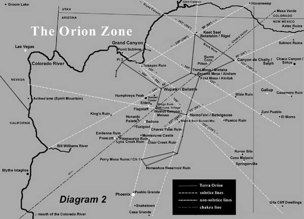
If we perch on the edge of Canyon de Chelly, looking not downward into the canyon but instead southwest at the winter solstice sunset, the sun on the horizon appears about five degrees south of the First Mesa village of Walpi. This line extended farther southwest beyond the horizon intersects both Sunset Crater and Humphreys Peak. Again, the reciprocal angular relationship between the two pueblo sites remains, so from Walpi at summer solstice sunrise the sun appears to rise from Canyon de Chelly fifty miles away. A northeastward extension of this 65-degree line eventually reaches a point in New Mexico near Salmon Ruin and Aztec Ruin. [4] In addition, a winter solstice sunrise line (120 degrees) drawn from Walpi past Wide Ruin traverses the Zuni Pueblo (a tribe closely related to the Hopi) and ends just south of El Morro National Monument. [5]
Standing during winter solstice sunrise on the edge of Tsegi Canyon where the ruins of Betatakin and Keet Seel are located, we look southeast along the edge of Black Mesa and watch the sun come up over Canyon de Chelly and Canyon del Muerto. The sun is in fact at 120 degrees on the horizon directly over Antelope House Ruin in the latter canyon. An extension of the same line into New Mexico intersects Casamero Ruin. [6] From the same spot at Tsegi Canyon also on the first day of winter, we see the sun set at 240 degrees azimuth over Grand Canyon more than eighty miles to the southwest. From Tsegi a summer solstice sunrise line of 60 degrees intersects Hovenweep National Monument in southeastern Utah, well known for the archaeoastronomical precision of its solstice and equinox markers. Again from Tsegi a sunset line of 300 degrees crosses Bryce Canyon National Park and Paunsaugunt Plateau in southern Utah, where nearly one hundred and fifty small Anasazi and Fremont ruins have been identified.[7]
If we travel one hundred and twelve miles almost due south of Tsegi Canyon to Homol’ovi, the summer solstice sunset appears eight degrees south of Wupatki, which is fifty miles northwest of where we are standing. This line (designated as H in Diagram 1) running between Homol’ovi and Wupatki passes between Grand Falls, an impressive cataract along the Little Colorado River, and Roden Crater, a volcanic cinder cone that artist James Turrell has turned into an immense earth sculpture, to finally end at Tusayan Ruin on the south rim of Grand Canyon. Again, from the reciprocal village of Wupatki the winter solstice sun rises just north of Homol’ovi, which is at 128 azimuthal degrees in relation to the former site. This Wupatki-Homol’ovi line extended southeast passes just south of Casa Malpais Ruin and ends less than ten miles south of Gila Cliff Dwellings. [8]
From Homol’ovi a winter solstice sunrise line (120 degrees) falls seven degrees north of Casa Malpais [9]and three degrees north of Raven Site Ruin [10], both north of the town of Springerville. From Homol’ovi at winter solstice sundown (240 degrees), the sun passes directly through East and West Sunset Mountains, the gateway to the Mogollon Rim. This line from Homol’ovi proceeds past the early fourteenth century, thousand-room Chavez Pass Ruin on Anderson Mesa (in Hopi, Nuvakwewtaqa, “mesa wearing a snow belt”) [11]and continues along the Palatkwapi Trail down to Verde Valley, ending near Clear Creek Ruin. If the summer solstice sunrise line (60 degrees) is extended from Homol’ovi into New Mexico, it intersects the vicinity of Chaco Canyon, perhaps the jewel of all the Anasazi sites in the Southwest. In this astral-terrestrial pattern Chaco corresponds to Sirius, the brightest star in the heavens located in Canis Major.
In this schema each village is connected to at least one other by a solstice sunrise or sunset point on the horizon. The interrelationship provided a psychological link between one’s own village and the people in one’s “sister” village miles away. Moreover, it reinforced the divinely ordered coördinates of the various sky cities come down to earth. Not only had Masau’u/Orion spoken in a geodetic language that connected the Above with the Below, but also Tawa had verified this configuration by his solar measurements along the curving rim of the tutskwa, or sacred earth.
Non-solstice Lines, the Grand Chakra System, and the Hopi Winter Solstice Ceremony
In addition to the solstice alignments, a number of intriguing non-solstice lines exists to corroborate the pattern as a whole. As heretofore stated, an extension of the solstice line between Oraibi and Wupatki (the belt and left shoulder of the terrestrial Orion respectively) would ultimately end on the Colorado River at the point where a major trail east toward Anasazi territory began. Similarly, if the non-solstice line between Walpi and Homol’ovi (the belt and the right shoulder respectively) is extended, it intersects the wrist of the constellation and terminates within five miles of the important Hohokam ruin site and astronomical observatory of Casa Grande Ruins National Monument, near the Gila River one hundred and fifty miles to the south. We have also already discussed the extension of the Walpi-Canyon de Chelly solstice line (Orion’s right leg) ending up at the Salmon-Aztec ruin area. An extension of the Oraibi-Betatakin non-solstice line (Orion’s left leg) would bring us to Glen Canyon National Recreation Area nearly fifty miles to the north. Ruefully, hundreds or perhaps even thousands of small Anasazi ruins were submerged by the construction of the Glen Canyon Dam in 1963, and the few that remain can only be reached by boat.
Another alignment of ancient pueblo sites forms the grand chakra system of Orion and indicates the direction of the flow of spiritual energy. Drawing a line southwest from Shungopovi/Alnilam, we pass less than five miles southeast of Roden Crater and Grand Falls, both mentioned above. Continuing southwest the line runs by Ridge Ruin [12], through Winona Village [13], and into the forehead of Orion, namely, Walnut Canyon National Monument, a significant mid-twelfth century Sinagua ruin located in the foothills of the San Francisco Peaks. If the line is extended farther still, it intersects the red rock country of Sedona with its electromagnetic vortices, passing the small but gorgeously located ruin and pictograph site of Palatki, or “Red House,” as well as the larger Honanki, or “Bear House.” In Verde Valley the newly energized vector directly transits Tuzigoot National Monument, a major thirteenth century Sinagua ruin of over one hundred rooms perched on a hilltop for the probable purpose of stellar observation. The line traverses the Black Hills of Arizona, goes by the newly excavated Emilienne Ruin [14] in Lonesome Valley, intersects the Fitzmaurice Ruin [15] located upon a ridge on the south bank of Lynx Creek in Prescott Valley, continues through the small Lynx Creek Ruin at the northern base of the Bradshaw Mountains, treks across the northern limits of the Sonoran desert, and passes near geoglyphs [16] in Arizona and California to ultimately reach a point just north of the mouth of the Colorado River, perhaps the place where the ancients migrating on reed rafts from the Third to the Fourth World entered the territory. This line extended in the other direction from Shungopovi travels northeast across Black Mesa, passing just southeast of Four Corners to finally end up at the major Anasazi sites at Mesa Verde National Park in southwestern Colorado.
In this series of villages we see eleven both major and minor Anasazi or Sinagua ruins and one Hopi pueblo perfectly aligned over a distance of over 275 miles within the framework of the tellurian Orion. The probability that these were randomly distributed is highly unlikely and increases the possibility that Masau’u (or some other agent perceived as being divine) directed their positioning. This “ley line” forms a grand chakra system that provides an inseparable link and a conduit of flowing pranic earth energy from the Hopi Mesas to the evergreens forests of the San Francisco Peaks. More specifically, Walnut Canyon symbolizes the Third Eye, or pineal gland (etymologically derived from the Latin word pinus, or “pine cone”), of Orion.
At this point we might ask: Why is the template of Orion placed on the earth at the specific angle that we find it relative to longitude? The “chakra” line mentioned above, which runs in part from Shungopovi/Alnilam (the belt of Orion) to Walnut Canyon/Meissa (the head of Orion) is 231 degrees azimuth in relation to Shungopovi. The azimuthal direction of southwest is 225 degrees. The axis for the terrestrial Orion is thus within six degrees of northeast/southwest. If we stood at Shungopovi shortly after midnight nine centuries ago on the winter solstice and looked southwest, we would find the middle star of Orion’s belt hovering directly above the southwest horizon at an altitude of about 38 degrees. Specifically, at 1:15 a.m. on December 22, 1100 A.D., Alnilam was at 231 degrees azimuth. [17] In other words, gazing from the central star of the earthbound belt of Orion toward its head located in the foothills of the San Francisco Peaks where the katsinam live, we would see the celestial constellation precisely mirror the angle of the terrestrial configuration.
But what is the significance of this precise time when the middle star in Orion’s belt is at 231 degrees? At the very moment we are watching this sidereal spectacle, “one of the most sacred ceremonies” [18] of the Hopi known as the Soyal is taking place in the subterranean chamber called a kiva. Just past its meridian Orion can be clearly seen through the hatchway. This is the time “when Hotomkam [Orion’s belt] begins to hang down in the sky.” Now a powerful, barefooted figure descends the kiva ladder. He is painted with white dots that resemble stars on his arms, legs, chest, and back. He carries a crook on which is tied an ear of black corn, Masau’u’s maize signifying the Above. One account identifies him as Muy’ingwa, the deity of germination related to Masau’u. [19] Another calls him “Star man,” ostensibly because his headdress made of four white corn leaves represents a four-pointed star, perhaps Aldebaran in the Hyades. [20] This person takes a hoop covered with buckskin and begins to dance. His “sun shield” fringed with red horsehair is about a foot across with a dozen or so eagle feathers tied to its circumference. Its lower hemisphere is painted blue, its upper right quadrant is red, and its upper left quadrant is yellow. Two horizontal black lines for the eyes and a small downward pointing triangle for the mouth are painted on the lower half of this striking face of Tawa. Alexander Stephen, who witnessed the ritual at Walpi in 1891, remarked that the Star Priest stamps upon the sipapu (the hole in the floor of the kiva that links it to the Underworld) as a signal to start the most important portion of the ceremony. [21] This occurs just after 1:00 a.m., the time on this date in 1100 A.D. (the approximate onset of settlement on the Hopi Mesas) when Orion was at 231 degrees of azimuth.
As the dance rhythm crescendos, the “Star man” begins to twirl the sun hoop very fast in clockwise rotation around the intercardinal points between two lines of Singers, one at the north and the other at the south. To quote A. M. Stephen, by his “mad oscillations” he is attempting to turn back the sun from its southward journey. “All these dances, songs, and spinning of the sun are timed by the changing positions of the three stars, Hotomkam, overhead. Now is the time this must be done, before the sun rises and takes up his journey.” [22] If this were merely a solar ritual, we assume that it would take place at sunrise. On the contrary, the sidereal position of Orion must reflect the terrestrial positioning of the constellation, which occurs only after the former has passed its meridian, that is, “…when Hotomkam begins to hang down in the sky.” Prior to dawn runners are sent out to the shrines of both Masau’u (Orion) and Tawa (the sun) in order to deposit pahos (prayer feathers), offerings to the two gods whose complex interaction helps to assure the seasons’ cyclic return, keeping the world in balance for yet another year.
Egyptian Parallels to the Arizona Orion
In their bestseller The Orion Mystery [23], Robert Bauval and Adrian Gilbert have propounded what is known as the Star Correlation Theory. (Their book, incidentally, provided the initial impetus for writing the present article and recently published book.) These co-authors have discovered an ancient “unified ground plan” in which the pyramids at Giza form the pattern of Orion’s belt. According to their entire configuration described briefly here, the Great Pyramid (Khufu) represents Alnitak, the middle pyramid (Khafre) represents Alnilam, and the slightly offset smaller pyramid (Menkaure) represents Mintaka. In addition, two ruined pyramids –one at Abu Ruwash to the north and another at Zawyat Al Aryan to the south– correlate to Saiph and Bellatrix respectively, while three pyramids at Abusir farther south correspond to the head of Orion. Bauval and Gilbert also believe that the pyramids at Dashour, namely, the Red Pyramid and the Bent Pyramid, represent the Hyades stars of Aldebaran and Epsilon Taurus respectively. Furthermore, this schema correlates Letopolis, located due west across the Nile from Heliopolis, with Sirius, the brightest star in the sky. As co-author Gilbert states in his later book:
“It was Bauval’s contention that the part of the Milky Way which interested the Egyptians most was the region that runs from the star Sirius along the constellation of Orion on up towards Taurus. This region of the sky seemed to correspond, in the Egyptian mind at least, to the area of the Memphite necropolis, that is to say the span of Old Kingdom burial grounds stretching along the west bank of the Nile from Dashur to Giza and down to Abu Ruwash. At the centre of this area was Giza; this, he determined, was the earthly equivalent of Rostau (Mead’s Rusta), the gateway to the Duat or underworld.” [24]
The region in Hopi cosmology corresponding to the Duat is called Tuuwanasavi (literally, “center of the earth”), located at the three Hopi Mesas. Similar to the ground-sky dualism of the three primary structures at the Giza necropolis, these natural “pyramids” closely reflect the belt stars of Orion. In addition, the entry to the nether realms is known in Hopi as the Sipapuni, located in Grand Canyon. This culturally sacrosanct area mirrors the left arm of Orion. Whereas the Egyptian Rostau is coextensive with the axis mundi of the belt stars formed by the triad of pyramids, the Hopi gateway to the Underworld in Grand Canyon is adjacent to the center-place but still close enough to be archetypally resonant.
In a later book entitled The Message of the Sphinx, Robert Bauval and co-author Graham Hancock describe the cosmic journey of the Horus-King, or son of the Sun, to the Underworld: “He is now at the Gateway to Rostau and about to enter the Fifth Division [Hour] of the Duat — the holy of holies of the Osirian afterworld Kingdom. Moreover, he is presented with a choice of ‘two ways’ or ‘roads’ to reach Rostau: one which is on ‘land’ and the other in ‘water’.” [25] We have been blessed with a wealth of Egyptian hieroglyphic texts, both on stone and on papyrus, with which we can reconstruct the Egyptian cosmology. Unless we consider petroglyphs more as a form of linguistic communication than as rock “art,” the Hopi and their ancestors, on the other hand, had no written language; hence we must rely on their recently transcribed oral tradition. In this regard the Oraibi tawa-mongwi (“sun watcher”) Don Talayesva describes an interesting parallel to Rostau.
As a young man attending the Sherman School for Indians in Riverside, California during the early years of the twentieth century, Talayesva became deathly ill and, in true shamanistic fashion, made a journey to the spirit world. After a long ordeal with many bizarre, hallucinatory visions [26], he reached the top of a high mesa and paused to look.
“Before me were two trails passing westward through the gap of the mountains. On the right was the rough narrow path, with the cactus and the coiled snakes, and filled with miserable Two-Hearts making very slow and painful progress. On the left was the fine, smooth highway with no person in sight, since everyone had sped along so swiftly. I took it, passed many ruins and deserted houses, reached the mountain, entered a narrow valley, and crossed through the gap to the other side. Soon I came to a great canyon where my journey seemed to end; and I stood there on the rim wondering what to do. Peering deep into the canyon, I saw something shiny winding its way like a silver thread on the bottom; and I thought that it must be the Little Colorado River. On the walls across the canyon were the houses of our ancestors with smoke rising from the chimneys and people sitting out on the roofs.” [27]
In this narrative the dry, narrow road filled with cacti and rattlesnakes, where progress is measured at just one step per year, is contrasted with the easy, broad road quickly leading to the canyon of the Little Colorado River. A few miles east of the confluence of this river and the Colorado River is the actual location of the Hopi “Place of Emergence” from the Third World to the present Fourth World. Physically, it is a large travertine dome in Grand Canyon to which annual pilgrimages are made in order to gather ritualistic salt. In correlative terms the Milky Way is conceptualized as the “watery road” of the Colorado River at the bottom of Grand Canyon– that sacred source to which spirits of the dead return in order to exist in a universe parallel to the pueblo world they once knew. This stellar highway is alternately seen as traversing the evergreen forests of the San Francisco Peaks, upon whose summit is a mythical kiva leading to the Underworld.
Talayesva’s account also includes such traditional otherworldly motifs as “the Judgment Seat” on Mount Beautiful, which supports a great red stairway, at least in his vision. (This peak is actually located about eight miles west of Oraibi.) Furthermore, we hear of a confrontation with the Lord of Death, in this case a threatening version of Masau’u (the Hopi equivalent of Osiris), who chases after him. Like the Egyptian journey to the Duat, the Hopi journey to Maski (literally, “House of Death”) has two roads– one on land and one on water. In this context we must decide whether the latter is really a code word for the sky. In the “double-speak” of the astral-terrestrial correlation theory, are these spirits in actuality ascending to the celestial river of the Milky Way? Is this, then, the purpose of the grand Orion schema? To draw a map on earth that points the way to the stars?
Returning to the subject of Orion projected upon the deserts of both Egypt and Arizona, we find both discrepancies and parallels. In terms of distinction the Egyptian plan is on a much smaller scale than the one incorporating the Arizona stellar cities, using tens of kilometers rather than hundreds of miles. Furthermore, the bright stars of Betelgeuse and Rigel are perplexingly unaccounted for in the Egyptian schema. [28] In addition, the Giza terrestrial Orion from head to foot is oriented southeast to northwest, while the Arizona Orion is oriented southwest to northeast. Of course, the pyramids are located west of the Nile River, while the Hopi Mesas are located east of the “Nile of Arizona,” [29] namely, the Colorado River. We should also point out that Abusir is not in the correct location to match Orion’s head on the constellatory template. Bauval and Gilbert state that Abusir is “…a kilometre or so south-east of Zawyat al Aryan…” [30], which is Bellatrix (Orion’s left shoulder). It is in fact about six kilometers southeast. In other words, Abusir is nearly four miles south-southeast of where it should be according to the Star Correlation Theory. Unlike Bauval, Gilbert, and Hancock, the present author has not traveled to Egypt, but the consultation of any scale map will verify this statement. [31]
Despite these few differences, the basic orientation of the Egyptian Orion is similar to that of the Arizona Orion, that is, south, the reverse of the celestial Orion. According to Dr. E.C. Krupp of the Griffith Observatory, this is one of the factors that invalidate the Orion Correlation Theory. [32] This critique, however, is the result of a specific cultural bias in which an observer is looking down upon a map with north at the top and south at the bottom. Imagine instead that the observer is standing on top of the Great Pyramid (or for that matter, at the southern tip of First Mesa) and gazing southward just after midnight on the winter solstice. The other two pyramids (or Mesas) would be stretching off to the southwest in a pattern that reflects the belt of Orion now achieving culmination in the southern sky. We can further imagine that if the upper portion of the terrestrial Orion were simply lifted perpendicular to the apparent plane of the earth while its feet were still planted in the same position (Abu Ruwash and an undetermined site in the case of Egypt; Canyon de Chelly and Betatakin in the case of Arizona), then this positioning would perfectly mirror Orion as we see it in the sky.
When the Anasazi gazed into the heavens, they were not looking at an extension of the physical world as we perceive it today but were instead witnessing a manifestation of the spirit world. Much like the Egyptian Duat, the Hopi Underworld encompasses the skies as well as the region beneath the surface of the earth. This fact is validated by the dichotomous existence of ancestor spirits who live in the subterranean realm but periodically return to their earthly villages as clouds bringing the blessing of rain. Even though the eastern and western domains ruled by Tawa remain constant, the polar directions of north and south, controlled by the Elder and Younger Warrior Twins (sons of the Sun) respectively, are reversed. Thus the right hand holding the nodule club is in the east and the left hand holding the shield is in the west, similar to the star chart. However, the head is pointed roughly southward instead of northward. This inversion is completely consistent with Hopi cosmology because the terrestrial configuration is conceptualized as a reversal of the spirit world, of which the sky is merely another dimension. An alternate explanation for the change of directions is the possibility that the pole shift, which destroyed the Hopis’ Second World, reversed the position of the constellation’s mundane aspect.
Looking up at Orion on a midwinter night, we can imagine that our perspectives have switched. Suspended high above the land, we gaze southwest toward the sacred katsina peaks and the head of the celestial Masau’u suffused in the evergreen forests of the Milky Way. Ironically, it is here on the high desert of Arizona that we also intuit the truth of the hermetic maxim attributed to the Egyptian god Thoth (Hermes Trismegistus): “As above, so below.”
For more on The Orion Zone, go to: www.theorionzone.com
The Orion Zone: Ancient Star Cities of the American Southwest
By Gary A. David
Publisher: Hayriver Press (a division of Ancient American magazine), November 2005
333 pages, perfect-bound trade paperback, 6″ X 9″, glossy
Includes 57 photos of ruins, rock art, diagrams, astronomical charts, and maps; 40 pages of notes and references
Cover price: $21.95 USD + $3.00 shipping and handling.
To purchase with a credit card, call toll-free: 1 (877) 494-0044
To use a check or money order for a signed copy, go to: www.theorionzone.com
Footnotes:
- Grigsby cited in Graham Hancock, Santha Faiia, Heaven’s Mirror: Quest For the Lost Civilization (New York: Crown Publishers, Inc. 1998), p. 127.
- J. McKim Malville, Claudia Putnam, Prehistoric Astronomy in the Southwest (Boulder Colorado: Johnson Books, 1993, 1989), p. 23.
— “Azimuth” is the arc of the horizon measured in degrees clockwise from the north point. - Inhabited from 1026 A.D. (or possibly earlier in light of the underlying pit house) through 1300, King’s Ruin has a thirteen-room foundation, twelve of which could have been two stories high. The five hundred pieces of unworked shells found at the site indicate substantial trade with the Pacific. Necklaces of turquoise, black shale and argillite were also found, one of the former materials consisting of 2,031 beads that stretched sixty-six inches long. Fifty-five graves were also discovered, containing sixty-six individuals, most of which were buried in the extended posture with heads oriented toward the east, awaiting Pahana’s (or the White Brother’s) return. Ginger Johnson, A View of Prehistory in the Prescott Region (Prescott, Arizona: privately published, 1995) pp. 8-9.
- Occupied for a few generations after 1088 A.D., abandoned and then reoccupied between 1225 and the late 1200s, Salmon Ruin near the San Juan River contained from between 600 and 750 rooms. It also had a tower kiva built on a platform twenty feet high that was made of rock imported from thirty miles away. Ten miles north of Salmon is Aztec Ruin (an obvious misnomer) located on the Animas River. At its peak development it contained about 500 rooms. Like the former, this latter site was originally inhabited in the early twelfth century by people of Chaco Canyon and then re-inhabited from 1225 to 1300 by people of Mesa Verde. In addition, it has a restored Great Kiva.
- Inhabited from 1226-1276 A.D., Wide Ruin, or Kin Tiel, about fifty miles due south of Canyon de Chelly, is an oval shaped pueblo of 150 to 200 rooms with a number of kivas. Atsinna pueblo, located atop a high mesa at El Morro National Monument, was a mid-thirteenth century rectangular structure, part of which was three stories in height. It had 500-1000 rooms and two kivas, one circular and the other square.
—a. David Grant Noble, Ancient Ruins of the Southwest: An Archaeological Guide (Flagstaff, Arizona: Northland Publishing, 1989, reprint 1981).
—b. Norman T. Oppelt, Guide to Prehistoric Ruins of the Southwest (Boulder, Colorado: Pruett Publishing Company, 1989, reprint 1981). - Constructed in the mid-eleventh century, Casamero Ruin was a small thirty-room pueblo. However, its Great Kiva, one of the largest in the Southwest, was seventy feet in diameter– even slightly more spacious than the better known Casa Rinconada at Chaco Canyon about forty-five miles to the north. Noble, Ancient Ruins, pp. 89-90; and Oppelt, Guide To Prehistoric Ruins, p. 177.
- Robert H. Lister and Florence C. Lister, Those Who Came Before: Southwestern Archeology in the National Park System (Tucson, Arizona: Southwestern Parks & Monuments Association, 1994, reprint 1993), p. 224.
- Located in the Mogollon Mountains of west-central New Mexico, Gila Cliff Dwellings National Monument is a ruin comprised of forty rooms in five separate caves located 150 feet above the canyon floor. The timbers of these structures have been tree-ring dated in the 1280s. The late Mogollon, or Mimbres, people are known for their exquisite black on white pottery, using realistic though stylized designs. The site was abandoned by 1400. Noble, Ancient Ruins, pp. 7-8.
- Casa Malpais is a thirteenth century Mogollon site of a hundred rooms with a square Great Kiva (one of the largest in the Southwest), catacombs, ceremonial rooms, three winding stone stairways and an astronomical observatory. Because of the nature of the artifacts found, such as crystals, ceremonial pipes, and soapstone fetish stands, it is thought to have been primarily a religious center. Stan Smith, “House of the Badlands,” Arizona Highways, August 1993, pp. 39-44.
- Located nearly ninety miles southeast of Homol’ovi and about twelve miles north of the Casa Malpais, the Raven Site (privately owned by the White Mountain Archeological Center) was occupied as early as 800 A.D. through 1450 and had more than eight hundred rooms and two kivas. James R. Cunkle, Raven Site Ruin: Interpretive Guide (St. Johns, Arizona: White Mountain Archaeological Center, no publication date).
- Jefferson Reid and Stephanie Whittlesey, The Archaeology of Ancient Arizona (Tucson, Arizona: The University of Arizona Press, 1997), p. 220.
- Occupied from 1085-1207 A.D., Ridge Ruin was a thirty-room pueblo with three kivas and a Maya-style ball court. It was also the site of the so-called Magician’s Burial. Thought by Hopi elders to be of the Motswimi, or Warrior Society, this apparently important man was interred with twenty-five whole pottery vessels and over six hundred other artifacts, including shell and stone jewelry, turquoise mosaics, woven baskets, wooden wands, arrow points, and a bead cap.
—a. Rose Houk, Sinagua: Prehistoric Cultures of the Southwest (Tucson, Arizona: Southwest Parks & Monuments Association, 1992), p. 7.
—b. Oppelt, Guide to Prehistoric Ruins, pp. 99-100.
—c. Reid and Whittlesey, Archaeology of Ancient Arizona, pp. 219-220. - The eponymous Winona Village, which was occupied at the end of the 11th century, contained about twenty pit houses and five surface storage rooms. Oppelt, Guide To Prehistoric Ruins, p. 99.
- The Emilienne Ruin had a foundation of twelve rooms, most of which could have been two stories high, plus eleven outlying one-room units.
- The Fitzmaurice Ruin, occupied from 1140-1300 A.D., had twenty-seven rooms in which were found beads, pendants, bracelets, and eighty-one amulets, including crystals, animal fetishes, obsidian nodules (so-called “Apache Tears”) and a curious six-faceted, truncated pyramid carved from jadeite and measuring 1.5 centimeters wide.
—a. Franklin Barnett, Excavation of Main Pueblo At Fitzmaurice Ruin: Prescott Culture in Yavapai County, Arizona (Flagstaff, Arizona: Museum of Northern Arizona, 1974), p. 95.
—b. Johnson, Prehistory in the Prescott Region, p. 16. - Similar to the Nazca lines of Peru, these intaglios of human, animal, and star figures, some over a hundred of feet long, were made by removal of the darker, “desert varnished” pebbles, exposing the lighter soil beneath. Reid and Whittlesey, Archaeology of Ancient Arizona, pp. 127-129.
–According to the Mohave and Quechan tribes of the lower Colorado River region, the human figures represent the deity Mastamho, the Creator of the Earth and all life. Notice the similarity between the name of this god and that of the Hopi earth god Masau’u. These figures are thought to be between 450 and 2000 years old. - Also at 1:15 a.m. on this date Bellatrix is at 240 degrees azimuth and Meissa is at 242 degrees azimuth. Forty minutes later Alnilam is at 240 degrees, the azimuthal degree at which the sun will set at 5:15 p.m. on this same day. Incidentally, at this winter solstice sunset time Orion is just rising on the opposite horizon, thus emphasizing the pivotal relationship of Orion/Masau’u and the Sun/Tawa. All astronomical computations performed with Skyglobe (KlassM Software). Mark A. Haney, Skyglobe 2.04 for Windows [floppy disk] (Ann Arbor, Michigan: KlassM Software, 1997.
- Edmund Nequatewea cited by John D. Loftin, Religion and Hopi Life In the Twentieth Century (Bloomington, Indiana: Indiana University Press, 1994, reprint 1991), p. 33.
- Frank Waters and Oswald White Bear Fredericks, Book of the Hopi (New York: Penguins Books, 1987, reprint, 1963), pp. 158-161.
- Richard Maitland Bradfield, An Interpretation of Hopi Culture (Derby, England: published by author, 1995), pp. 134-135.
- Stephen cited by Ray A. Williamson, Living the Sky: The Cosmos of the American Indian (Norman, Oklahoma: University of Oklahoma Press, 1989, reprint 1984), pp. 79-82.
- Waters and Fredericks, Book of the Hopi, pp. 161-162.
- Robert Bauval and Adrian Gilbert, The Orion Mystery: Unlocking the Secrets of the Pyramids (New York: Crown Publishers, Inc., 1994), p. 125 ff.
- Adrian Gilbert, Signs in the Sky (London: Bantam Press, 2000), p. 65.
- Graham Hancock and Robert Bauval, The Message of the Sphinx: A Quest For the Hidden Legacy of Mankind(New York: Three Rivers Press, 1996), p. 175.
–The discussion by Bauval, Gilbert, and Hancock of the Egyptian master plan is a great deal more complex than what is merely sketched out in this article. Their opus involves various facets such as precession of the equinoxes, star-targeted shafts in the Great Pyramid, and other topics that are not directly relevant to our discussion. However, this compelling work overall has challenged many orthodox ideas in Egyptology and has spawned heated debates both on the amateur and the professional levels. - Is it simply just another coincidence that the Hopi word tu’at, also spelled tuu’awta, meaning “hallucination” or “mystical vision,” sounds so close to the Egyptian Duat— indeed spelled by E.A. Wallis Budge, former director of antiquities at British Museum, as Tuat, that seemingly illusory realm of the afterlife?
- Don Talayesva, Leo W. Simmons, editor, Sun Chief: An Autobiography of a Hopi Indian (New Haven: Yale University Press, 1974, 1942), pp. 121-128.
- Recently two independent Egyptologists, Larry Dean Hunter and Michael Arbuthnot, claimed to have found all the stars of Orion represented by constructions on the Egyptian landscape. However, their terrestrial correlations are somewhat different than those originally put forth by Bauval and Gilbert. See “The Orion Pyramid Theory” in the Research/Articles section of the Team Atlantis website. www.teamatlantis.com
- Reid and Whittlesey, The Archaeology of Ancient Arizona, p. 112.
- Bauval and Gilbert, The Orion Mystery, p. 139.
- T.G.H. James, Ancient Egypt: The Land and Its Legacy (Austin: University of Texas Press, 1989, 1988), p. 41.
- E.C. Krupp, Skywatchers, Shamans, & Kings: Astronomy and the Archaeology of Power (New York: John Wiley & Sons, Inc.), pp. 290-291.