


Baalbek’s history goes back to the first millennium BCE when the Phoenicians built an altar and a courtyard in the Beqaa Valley dedicated to their god Baal, giving Baalbek its name. This Valley lies between the two Lebanese mountain ranges and was a strategic trading route. When the Greeks occupied the region in 332 BCE, they enlarged the existing temple and added to it. In 47 BCE, the Romans conquered Phoenicia. During their time, the Valley served as a source of grain for the Roman provinces of the Levant. When Julius Caesar settled in Baalbek in 15 BCE, he used the existing temple as a base from which to construct three temples dedicated to Bacchus, Jupiter, and Venus. Today, this temple of Bacchus is considered the grandest and best-preserved of all the Roman temple ruins.
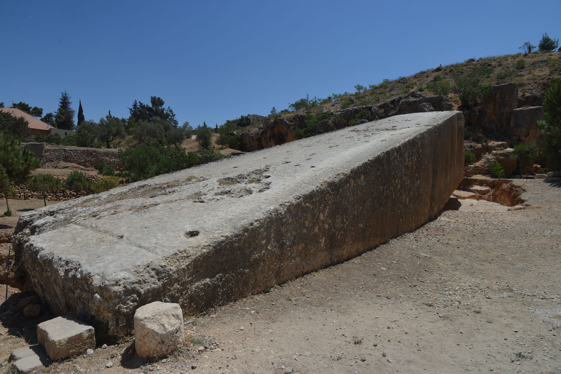
The temple of Jupiter is built on top of a podium which contains three of the largest stones ever hewed by man, known as “Trilithon”. The weight of each trilithon is 800 tons. Their quarry is located 800 meters (2,624.67 feet) southeast of the temple on the slope of the Anti-Lebanon mountain range. It seems that not all the stones quarried were used. One such humungous megalith was left above ground at the quarry. Recently, two similar stones were discovered buried underground. I shall detail the weights of these stones below.1
MEGALITHS IN THE QUARRY
- The first megalith, known as the “Pregnant Woman,” is located above ground. It weighs about 1,000 tons.
- The second megalith was discovered underground in 1990 and weighs 1,242 tons.
- The third megalith was also discovered underground in 2014 and weighs 1,650 tons. Its average dimensions are 19.6L x 6W x 5.5H meters (64.30 x 19.69 x 18.04 feet). It is the largest ever man-cut block.
Many questions arise from the discovery of these stones, such as who quarried the six blocks? Why were only three used in the podium, and how were they transported all the way from the quarry to the temple site? Obviously, one would assume that any one of the three civilizations, the Phoenician, the Greek or the Roman, quarried them. Many believe that it was the Romans who quarried the stones. Personally, I do not agree with this general belief for the following reasons:
- All the majestic ruins of the Romans do not have massive megaliths—this can also be said about the Phoenicians and the Greeks. The size of the stones they quarried and used in other locations is much smaller than the ones found in Baalbek. For example, only a few individual stones used in the ancient Roman Pont du Gard aqueduct in France that supplies 40,000 cubic meters of water per day are 6 tons.
- It is obvious that the structure of the great megalithic podium has a different pattern of construction to the Roman temple built above it.
- The podium megalith stones are weathered more than the stones in the temple of Jupiter. This can only mean that the megaliths are older.
- The many fabulous Roman ruins are evidence of the ancient Romans’ expertise in design, architecture, civil engineering, and planning. So, one wonders why they would invest their time, manpower, and money in quarrying such huge megaliths and not use them. Leaving three megaliths in the quarry (there may be more yet undiscovered) does not reflect the Roman professionalism. This leads me to conclude that they were not the ones who quarried the megaliths. They may not even have known of their existence.
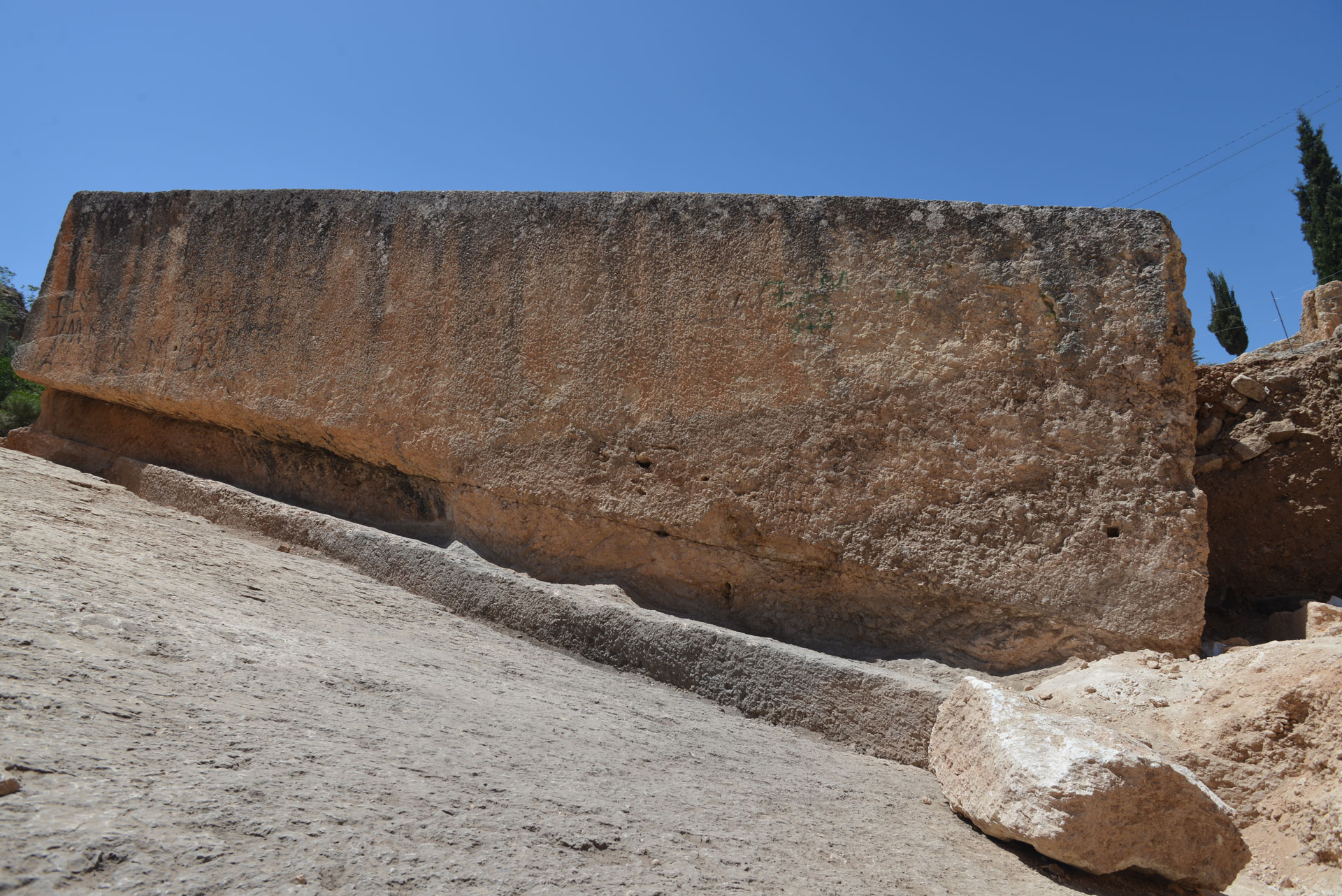
Photo: Santha Faiia
AN ANCIENT CIVILIZATION
If the Romans did not quarry the megaliths, who did?
There is evidence that the Beqaa Valley was inhabited by an ancient civilization as early as 9,000 BCE. I tend to believe that these people, who existed in the Valley around 10,000 BCE or earlier, quarried the six megalith stones to build a temple on some high ground in the area now known as Baalbek. They may have transported three stones to use in the podium construction, and before they had a chance to transport the other three, a universal cataclysm occurred on our planet. As a result, the civilization was wiped out, the temple stood unfinished, and the quarry was covered with debris. The situation remained unchanged until the Phoenicians came to the Valley, discovered the unfinished podium, and decided to build their temple as discussed above.
Is there any evidence for such a civilization to have settled in the Beqaa Valley? To answer this question, we need to investigate the archaeological site Gobekli Tepe.2
In 1996, the world’s oldest temple was discovered in Gobekli Tepe in the southeastern Anatolia region of Turkey, some 500 kilometers (310.69 miles) north of Baalbek. The site is a Tell (hill) 15 meters (49.21 feet) high. It was constructed around 10,000 BCE or earlier. T-shaped stone pillars made in a nearby quarry were transported to the site and then lifted into place in the temple. The pillars were arranged to form many circles. Two large pillars were placed in the middle of each circle. The pillars’ heights were up to 6 meters (19.69 feet) and weighed 10-20 tons each. One such pillar still in the quarry weighs 50 tons. As of May 2020, more than 200 pillars in about 20 circles were discovered, and they are carved with animal shapes, mystic drawings, and abstract symbols. Researchers found that Gobekli Tepe was built according to a precise architectural plan. If one were to join the centers of three of the circles, the lines would form a nearly perfect equilateral triangle. The details of the structure’s function remain a mystery. The purpose of the site could be a temple for worship, a burial place, or an astronomical observation center. The T-shaped stone pillars were also discovered in many places nearby Gobekli Tepe, such as in Hamazan Tepe, Karahan Tepe, Sefer Tepe, Tasli Tepe and Harbetsuvan Tepe.
These ancient people, who constructed the circles, must have been hunter-gatherers. Most probably, they used to follow their game from place to place. Lebanon is the bottleneck for migrating birds between Europe and Africa3. These hunters must have followed the flying route of migratory birds to the Beqaa Valley, where they established a settlement. The area is protected by mountains from the east and the west, has rivers, game, fertile land, and even wild wheat.
Large animals were domesticated for plowing and transportation, known as “beasts of burden”, between 4,000 and 3,000 BCE. Hence, it is reasonable to assume that, due to the lack of animal transportation during the time Gobekli Tepe was constructed, the people developed strong body muscles, especially in their legs and arms, which in turn meant that their walking endurance and speed are comparable to those of present-day Olympic athletes. The average speed of a race-walker today is about 12.5 kilometers/hour (7.77 miles/hour). If we assume that their walking speed was 10 kilometers/hour (6,21 miles/hour) and they walk only 10 hours a day, we can then conclude that it would have taken them about 5 days to cover the 500 kilometers (310.69 miles) distance between Gobekli Tepe and Baalbek. Therefore, the probability that these people reached the Beqaa Valley and settled in it around 10,000 BCE or earlier is extremely high. Having settled in the Valley, they would have wanted to build their circular temple. Hence, it is possible that they were the ones who excavated the quarry with the huge megalithic stones to build a podium upon which they would erect their elevated temple. Most probably, the steps that they performed to quarry, transport, and lift the megaliths in place are as follows:
QUARRYING THE MEGALITHS
Their first step was to cut the stones from a limestone quarry. Limestone is formed from the shells of ocean-dwelling organisms, such as oysters, clams, mussels, and coral. These organisms use calcium carbonate (CaCO3) found in seawater to create their shells and bones. Lebanon was completely submerged under seawater approximately 98 million years ago. Ancient sea left behind fossilized marine life that can be found on top of Lebanese mountains. My son and I excavated about 50 large ancient sea snail fossils from the top of a mountain about 1,900 meters above sea level. When they die, the water pressure compacts the sediments, thus creating limestone. As a result, limestone is extremely porous, making it easy to cut with hand tools. So, most probably their quarrying technique consisted of digging a trench around the block of stone they wished to remove and then cutting beneath the stone to free its base.
TRANSPORTING THE MEGALITHS
Their second step was to transport the blocks to the site. The limestone quarry is slightly higher in elevation than the base of the trilithon on which the podium sits by approximately 4.27 meters (14 feet). According to Google Maps, the elevation of the ground at the Pregnant Woman’s block in the quarry is 1,135.38 meters (3,725 feet), and the elevation at the top of the podium is 1,145.75 meters (3,759 feet). The height of the trilithon stones is approximately 4.88 meters (16 feet), and the height of the podium is approximately 9.76 meters (32 feet).
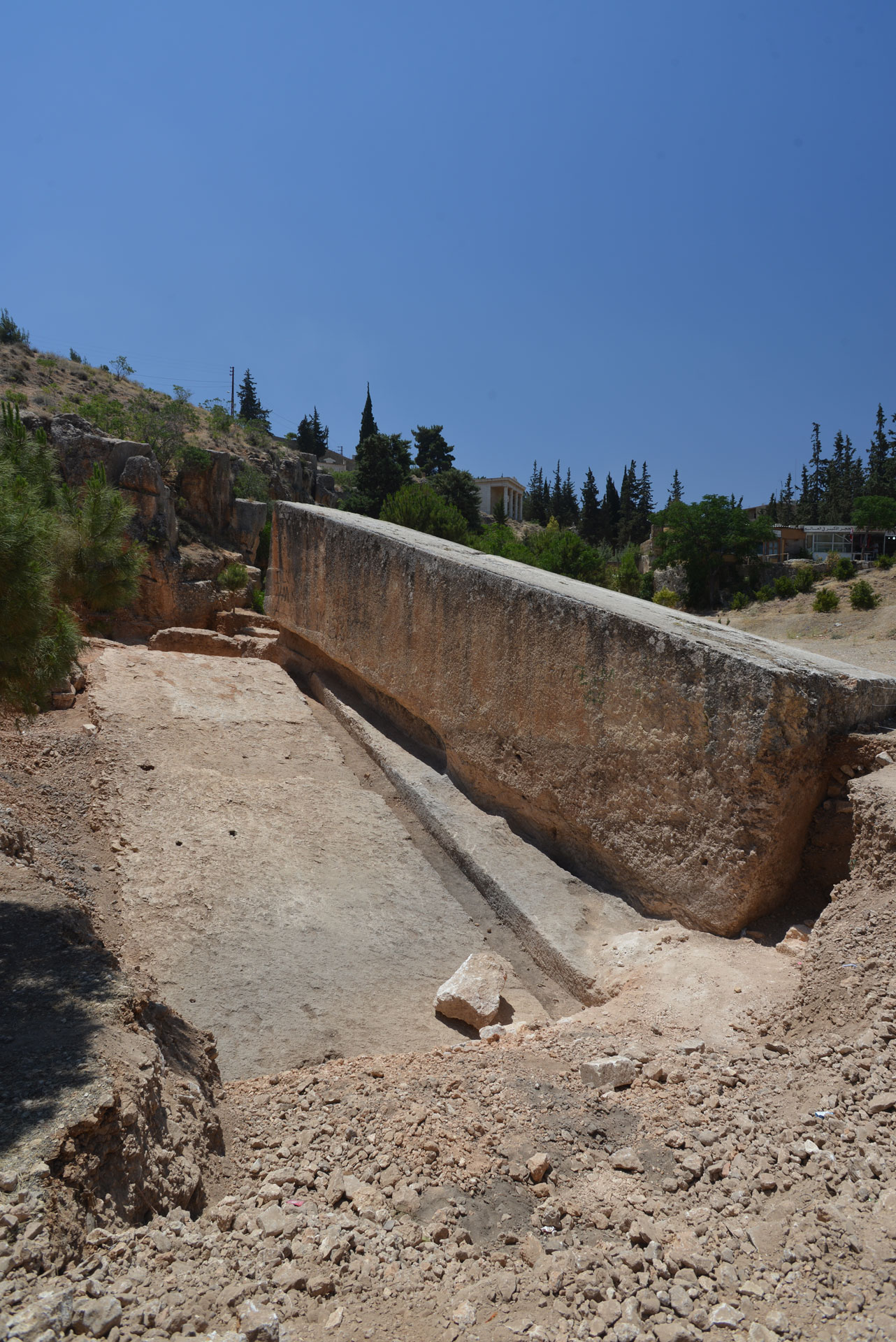
Photo: Santha Faiia
This data allows us to calculate the elevation at the base of the trilithon as follows:
The elevation at the top of the podium is 1,145.75 meters.
The height of the podium is 9.76 meters.
The height of the trilithon is 4.88 meters.
Therefore, the elevation at the base of the trilithon is:
1,145.75 – (9.76+ 4.88) = 1,131.11 meters (equivalent to 3,711 feet)
To find the difference in elevation between the ground at the quarry and at the base of the trilithon, we subtract the two elevations:
1,135.38 – 1,131.11 = 4.27 meters (equivalent to 14 feet)
This slope can then be calculated using trigonometry. The distance between the trilithon and the quarry is 800 meters, with an elevation difference of 4.27 meters. If the angle of elevation is Ø, then:
sin Ø = 4.27/800
sin Ø = 0.0053375
and Ø = 0.3°
Having obtained the elevation angle, the second step is to find the parallel component of the gravitational force on the 800-ton block, assuming it is on a frictionless icy incline. The force is calculated from the following formula4:
FÎÎ = m x g x sin Ø
Where:
FÎÎ = parallel gravity force on the slope (Newton)
m = mass of the block (800,000 kg)
g = acceleration due to gravity (9.8 m/sec2)
Ø = 0.3°, elevation angle (where sine 0.3 = 0.0053375)
By substitution,
FÎÎ = 800,000 x 9.8 x 0.0053375 = 41,846 Newtons
If a man can push a 100 kilograms (220 pounds) block on a horizontal surface, he requires 1,000 Newtons. This means the 41,846 Newton force is equivalent to 41 men pushing the block downwards on the slope. Although this slope is small, it would have been enough to generate a gravitational force to transport the megaliths from the quarry to the podium.
In addition to the above calculated figures, the time it will take the megalith to complete the 800-meter distance between the quarry and the podium is 175 seconds or approximately 3 minutes, and its velocity will reach 9.15 meters/second or 32.94 kilometers/hour (20.47 miles/hour) at the podium.
Most probably, these ancient peoples must have built a descending ramp from the quarry to the podium and waited for the ground to freeze in winter. Each megalith would then have been allowed to slide on a sledge descending freely down over the icy ramp. There was no need to pull or push the blocks. On the contrary, they had to hold the blocks, by rope or wooden wedges, in order to reduce their descending speed. A similar method to what I am proposing was performed about 250 years ago. The “Thunder Stone” is the world’s largest boulder ever to be moved only by human manpower.5 It was discovered in Finland around 1768 and weighed 1,500 tons (another reference gives it at 1,250 tons). It was moved about 6 kilometers (3.73 miles) on slippery icy ground in winter and then by a barge to St. Petersburg, in Russia, to serve as a pedestal for the Bronze Horseman, the equestrian statue of Peter the Great. Only 400 men were needed to move the boulder across the horizontal icy ground. In the case of Baalbek’s trilithon, the number of men needed to hold the descending megaliths from the quarry to the podium is definitely much less.
POSITIONING THE MEGALITHS
Their third step was to position the blocks on the podium. There was no lifting involved. The descending ramp ended at the base of the trilithon. So, they had only to maneuver the megaliths into their present place.
Unfortunately, they were unable to complete their temple. After moving only three megaliths, it is most likely that a universal cataclysm destroyed them.
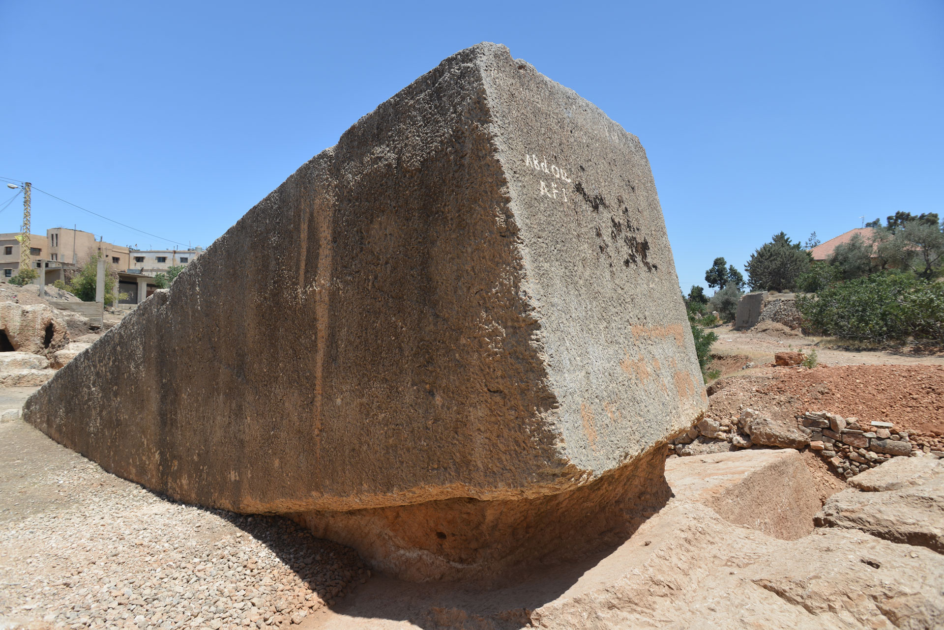
Photo: Santha Faiia
THE UNIVERSAL CATACLYSM
How likely is it that such a cataclysm did happen on Earth around 9,000 BCE? Below is a list of references supporting this hypothesis:
1. “In 1975, C. Mililani, of the University of Miami, analyzed the fossil remnants of microscopic organisms under the sediments of the floor of the Gulf of Mexico. From his studies, he concluded that 11,000 years ago [9,000 BCE] the Gulf of Mexico contained water that was much less salty than it is today. He suggested that the ice sheet has undergone sudden melting and that a vast flood of water had entered the Gulf of Mexico and raised the sea level markedly”.6
2. Professor J. Shaw, of Queen’s University, Canada, estimated that 82,000 cubic kilometers of water may have poured out from the ice to form the Drumlin Field in Saskatchewan, Canada. The largest river in the world, the Amazon, takes 10 years to discharge the same amount of water into the Atlantic Ocean. The estimated date for this flood is between 10,000 and 9,000 BCE.7
3. The Columbia Basin, in the USA, was probably the scene of the greatest stream of water for which there is geological evidence. One reference dates the flood to between 13,000 and 10,000 BCE, another dates it to between 11,000 and 9,000 BCE. Water spread from the Spokane valley over to the Columbia Basin, which is larger in size than France, Switzerland, and Belgium put together. The maximum flow rate of the water is estimated at 62 cubic kilometers per hour, a rate that is 15 times the combined flow rate of all the rivers of the world.8
4. A wall of water, 500 meters high, surged down the Chua River Valley from the Altai Mountains in Siberia at 144 km per hour. The estimated date of this flood is between 12,000 and 10,000 BCE.9
5. In 10,000 BCE, the size of the Nile River was 1,000 folds more than at the present time.10
6. Between 10,000 and 9,000 BCE, the Gulf Stream stopped its flow in the Atlantic Ocean abruptly. As a result, Britain and Europe froze for 1,300 years, and icebergs appeared as far as Portugal.11
7. About 9,000 BCE, there were severe changes in the large mammal population in many parts of the world. In North America, eight large mammal species became extinct, including the mastodon and the mammoth.12
8. In Alaska, millions of frozen animals and trees were found mingled together in what could only be attributed to a terrible catastrophe. Millions of animals, such as mammoths, mastodons, and bison, were found ‘torn limb from limb’. Trees were uprooted and thrown, along with animals, in a haphazard fashion. Frank Hibbing, a professor of archaeology, visited Alaska in 1941. He wrote: “In many places the Alaskan muck blanket is packed with animal bones and debris in trainload lots… Within this mass, frozen solid lie the twisted parts of animals and trees intermingled with lenses of ice and layers of peat and mosses. It looks as though in the middle of some cataclysmic catastrophe the whole Alaskan world of living animals and plants was suddenly frozen in mid-motion in grim charade.” The estimated date of the catastrophe is between 10,000 and 9,000 BCE.13
9. Evidence of the worldwide destruction of mammals is found in the Siwalik Hills, foothills of the Himalayas, central Burma, Europe, Asia, and Siberia. The estimated remains of extinct animals along the rivers of northern Siberia are 10 million. N.K. Vereshchagin of the Zoology Institute in Leningrad estimates that the arctic coastal plain between Yana and Koyma alone contains at least half a million tons of mammoth tusks. The estimated date for the disappearance of the mammoth is between 11,000 and 9,000 BCE.14
10. The islands of Leakhov, Stolbovoin, Belkov, and the New Siberian Islands are packed with mammoth bones. Some skeletons and carcasses were found complete, but the majority were torn apart by a gigantic force. Microscopic studies of the skin revealed red blood corpuscles, a sign of sudden death by suffocation. Also, the explorers of the New Siberian Islands found some trees uprooted and others partly upright and buried in the frozen soil. They believe a forest existed on the Islands before they were suddenly devastated between 10,000-9,000 BCE.15
11. According to Solon, the Egyptian priests informed him that the continent of Atlantis vanished under the sea around 9,500 BCE.16
12. Spartel Island, an island close to the Strait of Gibraltar, vanished under the sea around 9,000 BCE.17
13. According to geological evidence, a cataclysm occurred on Earth between 10,000-9,000 BCE. It brought about the end of one geological era (Pleistocene) and ushered in a new one (Holocene).18
14. The Sahara Desert in Africa was the home of a flourishing civilization. It had jungles, rivers, and possibly a lake. The change in its appearance was brought about by an acute change in temperature and climatic conditions. It is believed that around 9,000 BCE, a cataclysm occurred on Earth, causing the Sahara to convert from an inhabited land into a desert. In 1994, when the space shuttle Endeavour took a radar scan of the Sahara, it revealed an ancient river channel buried under the surface of the desert.19
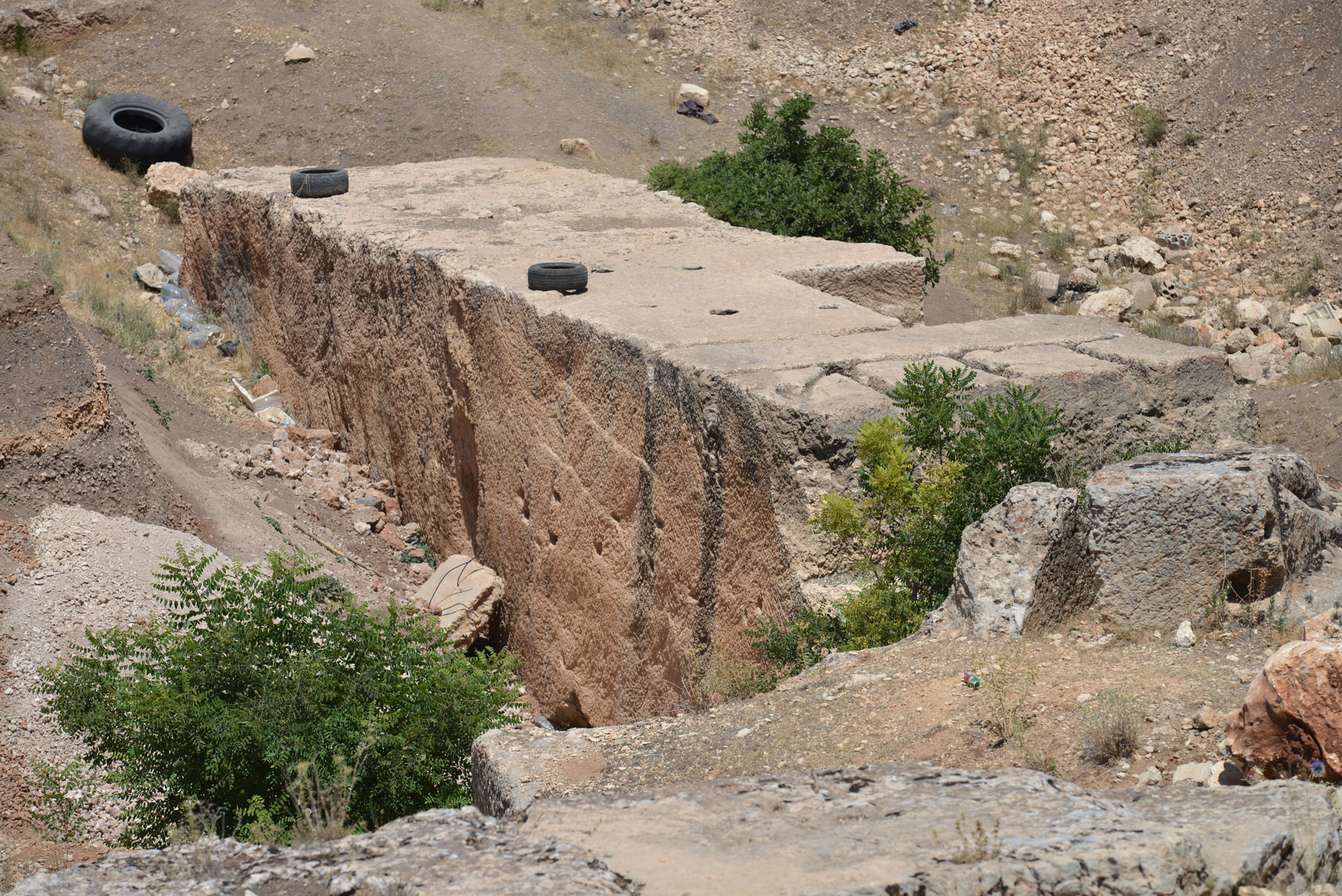
Photo: Santha Faiia
CONCLUSION
The mystery of Baalbek’s megaliths remains one of the most compelling enigmas in human history. The sheer size of the trilithon stones, combined with the lack of comparable Roman, Greek, or Phoenician engineering examples, points to a much older and possibly forgotten civilization. By drawing parallels with the builders of Gobekli Tepe – whose existence predates known historical societies by millennia – I open the door to a plausible scenario in which an advanced prehistoric culture once flourished in the Beqaa Valley.
The hypothesis that these ancient people quarried, transported, and positioned the massive stones before being halted by a universal cataclysm is supported not only by the physical evidence at Baalbek but also by the geological data suggesting a sudden global disruption around 9000 BCE. This evidence implies that the temple platform at Baalbek may be one of the last surviving monuments of a lost chapter in human civilization.
The article invites archeologists, historians, engineers, and curious minds to look deeper — beneath the ruins, beneath conventional timelines, and beneath our collective memory — to uncover the hidden pages of humanity’s deepest past.
REFERENCES
-
-
- https://eugene.kaspersky.com/2019/10/10/more-from-baalbek-ancient-stone-construction-hi-tech/
- https://www.smithsonianmag.com/history/gobekli-tepe-the-worlds-first-temple orhttps://en.wikipedia.org/wiki/Gobekli_Tepe
- https://www.undp.org/sites/g/files/zskgke326/files/migration/lb/ef78fa19792c669181af960daeb556b9b1c296f88c3fd127cb000df5c1c3ac86.pdf
- https://simple.wikipedia.org/wiki/Inclined_plane
- https://www.ancientpages.com/2018/06/14/the-thunder-stone
- http://www.bearfabrique.org/floods/mfloods.html.
- Ibid
- http://www.dnr.wa.gov/geology/columbia.htm.
- http://www.science-frontiers.com/sf092g08.htm.
- http://www.world-mysteries.com/mpl_2_4.htm.
- http://maritimes.buffaloimc.org:8080/news/2004/02/
7311_comment.php. - http://www.american.edu/TED/mammoth.htm.
- http://www.amendez.com/Noah’s%20Ark%20Articles/
NAS%20worldwide%20Mammal%20Massacre.pdf. - Ibid.
- http://www.grahamkendall.net/Unsorted_files-2/A312-frozenMammoths.txt http://www.talkorigins.org/faqs/mammoths.html.
- http://www.gi.alaska.edu/ScienceForum/ASF1/122.html.
- Luce 1969: 209. Luce, J.V.The End of Atlantis. London: Thames & Hudson, 1969.
- http://www.antiquity.ac.uk/ProjGall/kuhne.http://www.news.bbc.co.uk/1/hi/sci/tech/3766863.stm.
- http://encyclopedia.thefreedictionary.com/10th%20millennium%20BC.
- http://starryskies.com/articles/dln/1-97/nile.html.
-
What if they were poured in place? One bucket at a time? Have they been analysed to rule this out? Foti has shown that natron can be used to remake stone that can be worked as soft at room temperature.
The one in the structure was poured there. The “still in the ‘quarry'” ones could have been done to reinforce the illusion that they were quarried in one piece whilst hard, and moved, which is of course just silly. Nobody can do that. Which makes it even more impressive, so for propagandistic purposes, to fool visiting elites or whatever, to make it look like they were powerfully strong or giants when they were just good chemists?
I don’t doubt ancient stone shaping, and geopolymer use. I wonder if people without those skills came along afterwards and tried to duplicate what they found with regular stone working skills.
Great hypothesis, i wish we could find more evidence of that civilization from 10000 years ago.
HERMEL PYRAMID
Further to your comment, I have developed additional possible information about the ancient civilization in Baalbek — which I propose to name the “Golbakian” — that may have existed around 12,000 years ago.
The Kamouh el Hermel, or Hermel Pyramid, is a striking monument located on a hilltop about 45 km (28 miles) north of Baalbek1. Its location is highly strategic, overlooking ancient trade routes and the fertile plains of the Beqaa Valley. The structure stands approximately 27 meters (89 feet) high and is built on a three-stepped basalt base. At its foundation are two massive limestone blocks, each estimated to weigh between 40 and 50 tons. All four faces of the pyramid’s base are covered with graffiti. To date, no entrance has been discovered.
The exact origin and purpose of the Hermel Pyramid remain a mystery. Local legends claim that a giant used the monument as a marker to find his way home, while others suggest that ancient gods built the pyramid.
The most striking feature of the pyramid is indeed the two massive stone blocks. No other monument in the Middle East — not even the Valley of the Tombs in Palmyra, Syria — shares the same structural characteristics. The cutting, transport, and precise placement of such massive stones is a hallmark of the “Golbakian” civilization. Consequently, I propose that they may have been the builders of the Hermel Pyramid.
Possible Functions
1. Lighthouse or Signal Marker – The monument may have served to indicate the location of the Golbakian settlement at Baalbek to travelers arriving from the southeastern Anatolia region.
2. Stele or Territorial Marker – It could have functioned as a commemorative stele, signaling to future generations that an advanced civilization once occupied the Beqaa Valley. Historically, conquerors often left steles to mark their territorial claims. For example, at Nahr el-Kalb (Dog River), a few kilometers north of Beirut, there are about 20 inscriptions carved in limestone cliffs by successive conquerors over 30 centuries.
3. Funerary Monument – The pyramid may have served as the burial site of an important Golbakian ruler. A ground-penetrating radar (GPR) scan of the structure could reveal whether a burial chamber exists at its base. If a chamber containing skeletal remains were discovered, DNA testing could be compared with samples from southeastern Anatolia to investigate whether the Golbakians settled in the Beqaa Valley around 12,000 years ago.
^1 https://en.wikipedia.org/wiki/Kamouh_el_Hermel
Right. Grogg the hunter gatherer: “I ate a wildebeest, there’s nothing on TV… I think I’ll drag 800 ton stone blocks around.”
Many interesting ideas here geography, proximity and food supply. This is another piece that, to my mind, begins to relocate many ideas of a coming civilization further up the fertile crescent and away from the river arms of the ‘Cradle’. It’s a shame that we are still struggling with beliefs, and the symbolic expressions of these due to the, necessarily, fragmentary evidence.
Excellent article, thank you.
Thank you for sharing such a thoughtful and well-researched piece. The way you presented the connections and layered historical perspectives was both engaging and intellectually stimulating.
I especially appreciated how you challenged conventional timelines with clarity. It’s rare to find writing that balances depth with accessibility so effectively.
Several of those reference links do not work, any chance of an updated list so we can read further?
Dear Bob,
Thank you for taking the time to read the article and for your comment on the links. Below is an updated list.
Regards
Suhail
UPDATED REFERENCES
1.https://eugene.kaspersky.com/2019/10/10/more-from-baalbek-ancient-stone-construction-hi-tech/
2.https://www.smithsonianmag.com/history/gobekli-tepe-the-worlds-first-temple
https://en.wikipedia.org/wiki/Göbekli_Tepe
3.https://www.undp.org/sites/g/files/zskgke326/files/migration/lb/ef78fa19792c669181 af960daeb556b9b1c296f88c3fd127cb000df5c1c3ac86.pdf
4.https://simple.wikipedia.org/wiki/Inclined_plane
5.https://www.amusingplanet.com/2021/12/the-bronze-horseman-and-thunder-stone.html/
https://en.wikipedia.org/wiki/Bronze_Horseman
6. https://atlantipedia.ie/samples/tag/cesare-emiliani/
7.https://www.science-frontiers.com/sf066/sf066g11.htm
8.https://wa100.dnr.wa.gov/columbia-basin/ice-age-floods
9.https://www.science-frontiers.com/sf092/sf092g08.htm
The height is 50 meters not 500 meters
10.Not available on the net anymore
11.https://www.giss.nasa.gov/research/news/archive/20011119/
12.https://www.southampton.ac.uk/news/2021/12/ice-age-mammals.page
13.https://archive.org/details/in.ernet.dli.2015.86091
https://archive.org/details/lostAmericas1946
Ir reada: “it looks as though in the midst of some cataclysmic catastrophe of ten thousand years ago the whole Alaskan world of living animals and plants was …”
14. A 2000s review explains that Nikolai Vereshchagin, a leading expert, estimated hundreds of thousands of mammoths buried across Siberia, translating to millions of bones and around half a million tons of tusks along the Yana–Kolyma coastal region ScienceDirect+1Wikipedia+1Conservation OnLine+3Creation Ministries International+3Answers in Genesis+3.
15.https://www.science-frontiers.com/sf092/sf092g08.htm
16.https://www.britannica.com/topic/Atlantis-legendary-island
17.https://atlantipedia.ie/samples/spartel-island/
https://www.youtube.com/shorts/xlCe2N-PYbY
18.https://kids.frontiersin.org/articles/10.3389/frym.2024.1225865
19.https://www.ryanjhite.com/2024/10/29/uncovering-the-hidden-world-beneath-the-sahara-desert/
https://www.hrpub.org/download/20210430/EER4-14023148.pdf
I think I can shed some light on the cataclysm in the following article titled “How Did The Last Ice Age End?”
It seems that those who study this question have had some difficulty finding a climate related cause for the end of the ice age. Well, I don’t really think the ice age actually ended because there wasn’t one. What actually seems to have happened is an approximately 30 degree shift in the north pole location from somewhere in the Hudson bay to its current location. I believe this event was caused or initiated by the impact of a large asteroid or comet on the more than a mile thick ice sheet in west central Canada. It was probably a comet since very little evidence has been found in the fossil record and the historical approach descriptions in reference 1 sound more like a comet (they would not have seen an asteroid coming). A crater would not be found since the impact was on a very thick ice sheet.
We can be reasonably certain that the Earth’s rotational axis did not move very much because the energy needed for a 30 degree shift would have required a planet killing impact. What apparently occurred was a shift of the Earth’s crust over the mantle as described in reference 2, which documents measurements of the Earth’s magnetic field record stored in lava flows to accurately locate the relative shift of the magnetic pole. We know this type of movement can happen since we see it in continental drift. Also, the relative motion which occurred around the Earth indicates this is what happened. Siberia moved north resulting in fast freezing of large animals with temperate vegetation in their teeth and stomachs. Northern Antarctica acquired an ice sheet after its northern shore had been ice free as indicated in the ancient Oronteus Finaeus and other maps (reference 3). Had the Earth’s rotational axis shifted, the direction of movement would have been wrong for Siberia and Antarctica. Additionally, maps of the ice location during the ice age indicate it was centered close to Hudson Bay. Apparently northern Greenland, now ice covered, was ice free during the “ice age”. Northern Greenland has been proven to be ice free by an expedition which bored through the current ice sheet as reported in Jeffery Delviscio’s “Greenland’s Frozen Secret” article in July/August 2025 issue of Scientific American.
There is a significant amount of evidence that this occurred rapidly, probably in only a few minutes. There is widespread damage all over the world associated with the event as described in Reference 1. Ocean surges devastated coastal regions and left massive piles of broken bones and plants in mountain crevices. Earthquakes devastated much of the world, caused by motion and by forcing the crust over a non-spherical body having a several mile difference in diameter between the equator and the poles. The advanced megalithic civilization worldwide here before the so called ice age was nearly wiped out, probably resulting in legends of Atlantis. Allan and Delair indicate that the event caused several mountain ranges to form and raised the elevation of some megalithic cities in South America to heights which could not support the agriculture which had been there. There are historical reports of the stars spinning in the sky (Reference 1), The item that tipped the balance for me was a historical report indicating the sun rose and then set back to the east. When I read this one, I scoffed because the Earth’s rotation could not be stopped and restarted. However, I now realize this could have happened in parts of the eastern hemisphere if the crust rotation event occurred shortly after dawn there. I read this item many years ago and do not remember the source. If anyone knows where it came from, I would appreciate hearing from them. The spinning stars would have been seen anywhere it was a cloudless night.
There is a lot of physical evidence of the impact. The initial blast and subsequent firestorm is probably the extinction event that wiped out most of the large North American animals. Many cubic miles of ice would have been vaporized, melted or thrown out in massive chunks. The water and debris released caused the channeled scablands in eastern Oregon. The idea that the ice dam at lake Missoula formed and broke about 50 times is almost as unbelievable as the idea that a comet impact caused a 30 degree movement of the earth’s crust. It also apparently caused the formation of the great lakes, which is attributed to the ice age, but seems to be a little lacking in explanation of how without considering the impact. Many of the ice chunks tossed out landed in the southeastern U.S. creating the Carolina bays described in Reference 4. The location and orientation of the Carolina bays confirm the impact location and indicate there was a significant tangential force to cause the crust to slip in the right direction. Ocean levels probably were significantly raised initially by the amount of ice sheet immediately released. Significant local additional sea level effects including gigantic tidal waves would have occurred due to regional land elevation changes and lateral motion. These rapid sea level changes and tidal waves were the probable cause of the megalithic civilization decimation. Subsequent sea level rise would be caused by the Canadian ice cap melting faster than the Antarctica ice cap forming. The ultimate sea level reached is higher because there is now less ice cap and more sea ice than before the event as a result of the changed locations of the ice caps. It is not higher as a result of ending an ice age which did not occur.
It would not surprise me if the water vapor, water and ice particles tossed into the atmosphere and possibly into earth orbit would have resulted in 40 days of worldwide rain.
Reference 1: D. S. Allan & J. B. Delair, “Cataclysm”.
Reference 2: Charles Hapgood, “Path of the Pole”
Reference 3: Charles Hapgood, “Maps of the Ancient Sea Kings”
Reference 4: Antonio Zamora, “Killer Comet”
I agree with much of Mr. Jalbout’s excellent analysis and his summary of the Universal Cataclysm, as well as much of the content from the comments here. I do think, however, there is also room for the possibility of the ancient forgotten human civilization to have had a worldview that produced an advanced technology quite different in many ways from our own — a technology that the universal cataclysm could have wiped out completely. Those ancients used megalithic blocks with such ease as seen in the enigmatic clues we have left all over the world, with blocks of well over a thousand tones used in platforms such as Baalbek, the Temple Mount in Jerusalem, and various locations in the Andes of Peru and Bolivia. Ancient quarries all over the world such as the Yangshan quarry in China also show quarrying marks similar to our technologies today and often remnant blocks close in size to those at Baalbek. Thanks to Mr. Jalbout and all the thoughtful commentators.
Excellent analysis, and it all makes sense. Couple this with Dr. Richard Firestone’s excellent book, The Cycle of Cosmic Catastrophes about the explosion of a comet at the same time, and a great mystery may have been solved!
John McCauley – [email protected]
I’d like to add to my previous comment.
Again, the overall analysis of the origin of the Baalbek monoliths was well researched and presented.
If indeed the monoliths were shaped and moved prior to a cataclysmic comet event about 12,800-years ago, then that would have occurred just prior to the last glacial maximum. This would make it feasible that ice could have played a role in moving the 800-ton stones. However, even so, it is doubtful that there would have been no requirement for human exertion to move these enormous stones. Such a heavy weight would still tend to embed itself into the ground regardless of any available ice. I suspect that ice could have played a role as a form of “lubricant” (similar to the ancient Egyptians using water to “lubricate” sand when pulling an object), significantly reducing the coefficient of friction (C.O.F.) between the stone and the ground; let’s assume that no sled was used because of the logistics of building such a large sled and mounting the stone on it.
Even with a small C.O.F. at 5% x 1,600,000#, and with the shallow gradient from quarry to the site, the stone would require a pulling force of 65,000-80,000#. The average man could pull with the maximum force of 100# for short periods, making it necessary to have 650-800 men pulling the stone. The challenge would then be to create a lubricated path for the stone but a dry, non-slippery path for the pullers.