





Background
This essay is Part 1 of a four-part series drawn from my new book series, The Legend of Atlantis and the Science of Geology, whose first three volumes have been published. As is well known, orthodox geology considers the Atlantis legend, and all other such legends, including the Great Flood, to be little more than hyper-imaginative exaggerations of relatively ordinary events by our relatively primitive and superstitious forebears.
It is, of course, widely claimed that there is no evidentiary basis in the science of geology for lost continents, global catastrophes, overwhelming floods, or anything else of that nature, except perhaps an impact in the ocean or a natural dam outburst. However, these claims are, by uniformitarian necessity, pre-imposed on any and all evidence that might be presented. Hence, despite what much of the physical evidence itself might suggest, catastrophism is dismissed a priori—which is no way to treat any evidence, or theory, whatever it might be.
While, as noted, most geologists now accept the possibility of asteroidal impacts or dam failures causing extensive flooding, the evidence involved is much the same as that found (on land) over much of the northern hemisphere and ascribed to the Ice Age since the mid-19th century. Prior to that time, this evidence, comprising boulders, gravel and various other deposits and debris, was interpreted by the early geologists as being due to massive flooding. In many cases, and as is well known, Noah’s Flood was considered the agent responsible.
However, and quite contrary to the general impression given out by academia, geologists in general had abandoned the Great Flood as the agent responsible long before Charles Lyell ever wrote his books (1830-1833). In fact, by 1800, many geologists had adopted a diluvial approach to the science, involving large-scale and violent flooding in no way comparable to Noah’s quiet Flood (See Pallas, 1771; de Saussure, 1796, for example).
As we know from the biblical account, the legendary Great Flood began with heavy rainfall and rising water, allowing the ark to be lifted and carried away, with no mention made of any kind of violence. In contradistinction, the diluvialist interpretation of the Ice Age evidence (called the “drift” by Charles Lyell himself, because he thought it originated from drifting icebergs) was that it was due to mighty currents of water sweeping over the surface of the earth.
Volume 3, The Great Flood in Legend, Science and History, investigates the legend of the Flood in much the same scientific way as the approach taken to Atlantis. While the general theme is the same, the catastrophe of the Flood is not included in this essay. But, given its history and importance, future articles on aspects of the subject may be published.
Introduction to Four-Part Essay Series
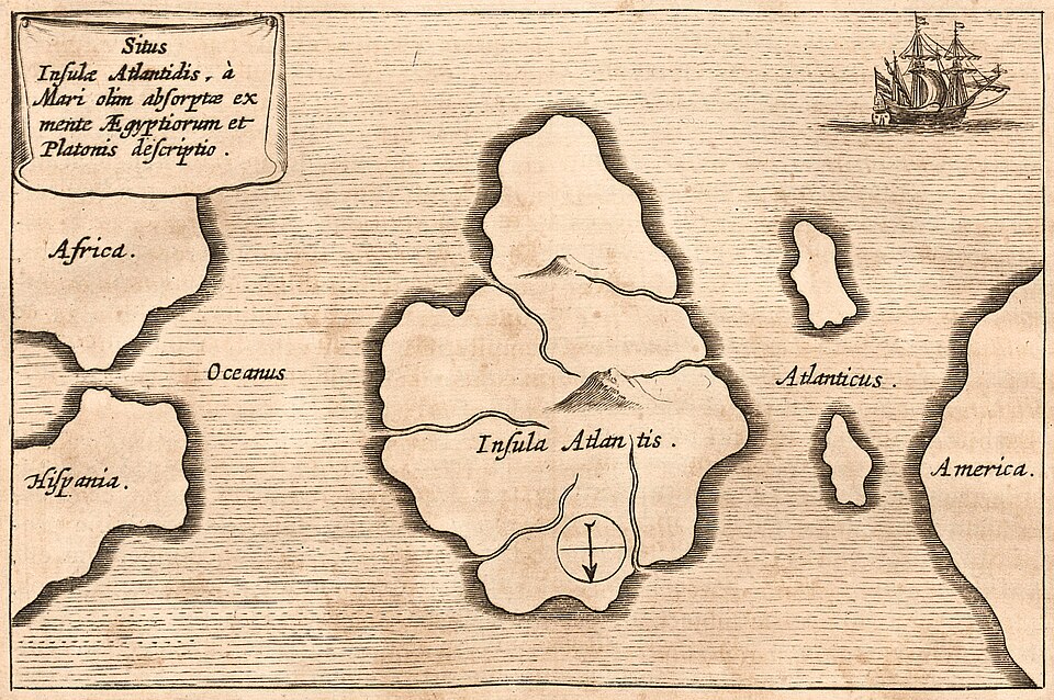
Athanasius Kircher’s map of Atlantis, from Mundus Subterraneus, vol. 1 (Amsterdam, 1678 edition), oriented with south at the top. Public Domain

Part 1 is, of course, based on volume 1, which is titled Atlantis and Catastrophe, Myth or Reality? and focuses particularly on the Atlantis legend, beginning with an assessment of its geological and geographical aspects, as they pertain to the Atlantic, as well as a thorough examination of the legend itself, and catastrophe legends in general, from a mythological and scientific perspective, and including the newish discipline of “geomythology.”
Part 2 of this essay series will be based on volume 2 of the book series, titled The Geology of Greece, Uniformity or Catastrophe? The focus will be on Greece and its geology, which, for the most part, is readily visible and accessible on the surface and has been well studied. Therefore, regardless of the uniformitarian position, we should have little trouble deciding whether the country has suffered a major catastrophe as described by the old Egyptian priest, who passed on the story of Atlantis to Solon in Plato’s account.
While the priest discusses the geology of Greece and the Aegean in general terms and describes the catastrophe’s effect on the country, he focuses especially on the Acropolis hill of primeval Athens, describing how it once looked and how it suffered heavy erosion from overwhelming floods. Part 3 of this essay series, also drawn from volume 2, will therefore comprise a detailed study of the Acropolis hill and its surroundings.
Part 4 of this essay series will be based on the future volume 5 of the book series, working title: Atlantis in the Atlantic, Legend or History? Here, we will return to the Atlantic and investigate the submarine geology of the Azores Plateau and nearby areas of the Mid-Atlantic Ridge, as well as the group of seamounts that lies to the south, one of which happens to be called “Atlantis.” Since plate tectonics theory, along with volcanic eruptions and earthquakes, is nowadays considered adequate to fully account for the Atlantic Ocean Basin as we find it, leaving no room for Atlantis, we will merely examine the evidence and ignore orthodox theory for the time being.
PART 1: ATLANTIS AND THE AZORES

Sete Cidades, São Miguel, Azores. Photo: Senchos, CC BY-SA 4.0

Introduction: Lost Atlantis!
Over the years and decades, possible locations for Atlantis have left few areas of the planet unmentioned. Suggestions have varied from the North Sea to the Mediterranean, and from the Sahara to Antarctica (and almost everywhere in between). However, little in the way of scientific evidence has been provided to support many of these proposed locations; moreover, many are on continental landmasses, which is an odd place to find an island. Despite the suggestive name Atlantis and the historical focus on the Atlantic, few writers in recent years seem to consider the Atlantic a likely candidate.
This is due, quite possibly and most likely, to the natural assumption that academia, with its plate tectonics theory, has the correct explanation and history of the Atlantic Ocean basin, as it so insistently claims. In which case, and if correct, there is no room in either science or history for the recent existence and catastrophic subsidence of a large landmass in the middle of the North Atlantic—at least not according to mainstream academia. This article, however (and the book series), dares to question plate tectonics theory, along with many other orthodox theories, which, for some reason, despite decades of study and research, never seem to attain the status of official, proven fact.
The Location of Atlantis:
Many writers have suggested the Azores Islands as a possible location for Atlantis, and indeed, these islands do appear to be more or less where Plato said Atlantis once existed. In which case, and given that these islands are built up from an extensive submarine plateau, the Azores islands, along with the plateau, would seem to be the most likely candidate for the lost Atlantean continent.
Any discussion of Atlantis and its possible current location must, of course, begin with the only source of the legend—Plato’s Timaeus and Critias—which together consist of a dialogue among four individuals, and within which the tale of Atlantis is related. One of the individuals, Critias, narrates a report brought back from Egypt by the famous statesman, Solon, who was told the tale by an old Egyptian priest, which means, on the face of it at least, that the story of Atlantis did not come directly from Plato, but indirectly from that priest.
When it comes to the location of the former island continent, the priest is quite specific, and it is difficult, to my mind, to misinterpret his description. As he says:
“. . . there was an island situated in front of the straits which are by you called the Pillars of Heracles . . . and was the way to other islands, and from these you might pass to the whole of the opposite continent which surrounded the true ocean; for this sea which is within the Straits of Heracles is only a harbour, having a narrow entrance, but that other is a real sea, and the surrounding land may be most truly called a boundless continent.” (Timaeus 25a, translated by Jowett, 1871)
This statement of the priest seems quite unambiguous, and signifies some knowledge of the western continent, now known as the Americas, which does tend to arc eastward to the north and south of the central North Atlantic Ocean, thus seeming to “surround” that part of the true ocean, and clearly outside the Pillars of Heracles.
What is rarely, if ever, noted in regard to this description of the islands and the opposite continent is that, on the one hand, it is accurate, and on the other, if Plato conjured up the tale, what in the world would prompt him to make up an “opposite continent” to go along with his supposedly invented Atlantis? In other words: Plato presents a picture of the Atlantic as a whole, with an island continent in the middle and mainland continents on either side, with the opposite continent surrounding the “true” ocean. This is an accurate picture no Greek of Plato’s time was supposed to have. Logic and evidence, therefore, suggest that the priest’s tale, and thus Plato’s legend, are quite possibly based on fact and accurate geographical knowledge.
Further confirmation is provided by the old priest when he describes the invasion by the Atlanteans. As he relates, the Atlanteans ruled over the islands and part of the continent, and besides these “. . . subjected the parts of Libya, within the Pillars of Heracles as far as Egypt, and of Europe as far as Tyrrhenia . . . endeavored to subdue at one blow our country and yours, and the whole of the land which was within the straits . . .” (Timaeus 25b, adapted from Jowett, 1871, and Lee, 1965). Hence, the priest makes a very clear distinction between the ocean, islands, and continent outside the Pillars of Heracles, and the land which was inside those pillars. This, of course, would rule out any Mediterranean location for the legendary island, especially Santorini, which has long been a persistent “alternative.”
Therefore, and according to the priest, Atlantis and other islands were formerly located in the Atlantic Ocean somewhere between Gibraltar and North America. The Azores Plateau now lies submerged about halfway between Gibraltar and Newfoundland, and constitutes a much thickened, triangular-shaped section of supposedly oceanic crust adjacent to, and straddling, the Mid-Atlantic Ridge (MAR), while south of the Azores are a number of large seamounts, some of which are flat-topped and more like sunken plateaus.
Fig. 1-1 below is a bathymetric map of the Atlantic. The circle shown (a rough guesstimate) encompasses the Azores and the seamounts to the south, and falls squarely in the area where Plato (or the priest) placed the fabled isle.
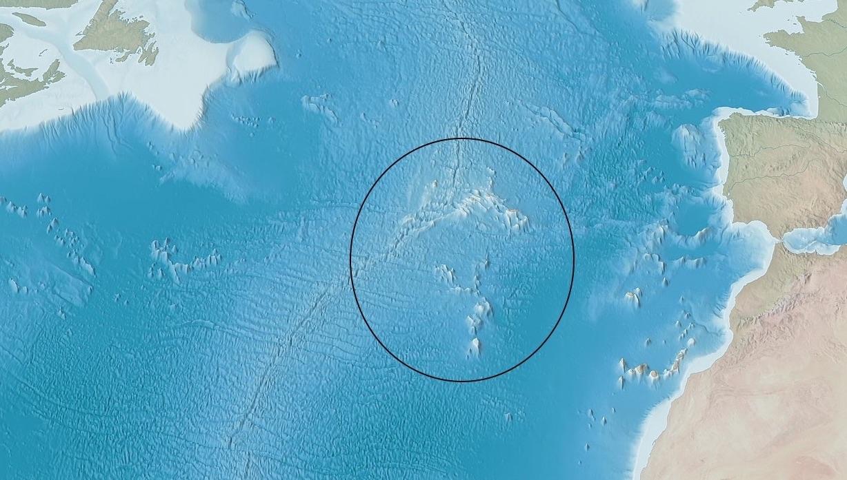
Fig. 1-1: Conjectured location of Atlantis based on the priest’s report.
Image: Tom Patterson, cartographer, via Library of Congress, Geography and Map Division, and Wikimedia Commons. Public domain (modified: cropped four sides; circle added).

Based only on the foregoing, therefore, the most obvious and likely candidate for the foundered Atlantis must be the Azores Plateau region, including the group of seamounts to its south, despite what academic orthodoxy and those who follow it might otherwise claim. Further, there is some debate and controversy within academia regarding the very origins of the Azores Plateau itself, especially its thickness and supposed underlying “hot-spot,” which we will briefly discuss in Part 4 of this essay series.
Description of Atlantis:
Additional evidence derives from the priest’s description of the island continent’s geography. Atlantis had a topography typical of many countries, with sea cliffs, mountains and valleys, rivers and lakes, and a large plain toward the south. In the north, mountains sheltered the plain from the cold north winds. This, therefore, suggests that Atlantis extended sufficiently to the north to the point that part of it, at least, was influenced by those cold winds. According to the priest, it rained on the plain during the winter but only on the mountains during the summer.
The climate of Atlantis, therefore, would appear to have been rather mild, with warm summers and cool winters, and much moderated by those northern mountains, which would, of course, have formed a natural barrier to rain clouds. As the moisture-laden air rose up against the mountains, it would have cooled, causing rain on the plain south of the mountains in winter. In summer, it would appear (quite logically) that the moisture-laden air had sufficient energy to make it up into the mountains before cooling enough to condense to rain.
As for the environment, the island was very fertile, with no shortage of food for wild animals; it had forests, wild fruits, game animals, and a large number of elephants. The soil was especially rich, which is suggestive of volcanic origin, quite in keeping with the igneous/volcanic nature of the Mid-Atlantic Ridge. Two crops per year were harvested, which, along with the elephants, suggests a subtropical climate, at least in the southern part, where the influence of the cold north winds did not extend; this reflects conditions on the Azores Islands today.
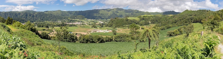
Fig. 1-2: View across Furnas, São Miguel Island. Image: Diego Delso, CC BY-SA 4.0.

The Azores are abundant in red volcanic soil, also grow two crops per year, and have a wonderfully mild climate. Like many volcanic regions, Atlantis had hot springs, and the priest reports that hot baths were used in both winter and summer. Today, like Iceland, the Azores also boast hot springs, and both coincidentally straddle the Mid-Atlantic Ridge, suggesting they are both located on higher points of the submerged Ridge, as are Peter and Paul’s Rocks, Ascension Island, and others elsewhere along the Ridge.
This is a rather telling piece of evidence from that old priest, especially in light of the fact, as noted above, that Greeks of Plato’s time supposedly knew nothing of the Atlantic. The mention of hot springs, typical of igneous provinces like the Mid-Atlantic Ridge, bespeaks some knowledge on the part of Plato or the Egyptian priest of the central Atlantic, if only derived from the Azores. And this is one of a number of issues that warrant some examination, especially concerning the charge that Plato invented the tale.
If he invented it, then where did all the details come from? How could Plato have known about the hot springs if he, as is generally presumed, knew nothing of the Atlantic? Further, how could he have known, or why did he invent, the presence of elephants, of all things? A corollary observation is that, if, again, Plato invented the tale, how did he get all the details correct? Major or minor, these details provided by Plato match the present-day conditions on the Azores, with few, if any, flaws or contradictions.
While elephants certainly imply a warm climate, the priest (or Plato) also mentions what has been generally interpreted as coconuts, and, hence, some part of Atlantis must have been south of latitude 26° N. Given the cold winter winds, two crops per year, the presence of elephants, and the climatic requirements of coconuts, the minimal latitudinal limits of Atlantis can be estimated to be from approximately 20° N to perhaps 45° N.
As far as the geology of Atlantis goes, the priest does not give a lot of information, but mentions that three types of rock were prevalent, black, white and red, and regardless of what type of rocks they actually were, it is significant that rocks of the same colors are found on the Azores today, and are likely igneous, though the white is probably limestone, at least on the Azores, if not on the ridge itself. Mining operations were also carried out, and gold, silver, and another metal called “orichalcum” (mountain copper) were obtained, though what orichalcum actually consisted of is something of a mystery.
However, oceanic (basaltic) provinces typically do not have much in the way of mineral content, and thus some remnant of continental crust must have comprised a part, at least, of the Atlantis landmass. And, indeed, continental-type rocks have been found in a number of places on the Mid-Atlantic Ridge, while more may be buried under later volcanics.
While there is not a lot of geology pertaining to the Atlantic Ocean in Plato’s legend, it is curious that what is there is both internally consistent and generally consistent with the limited amount of geological and other evidence, such as climatic and ecologic, we have from that part of the globe where Plato appears to have set his “legendary” island.
Furthermore, and what is generally ignored by most writers on the subject, academic or otherwise, is that for a legendary island, the description of Atlantis is surprisingly detailed and comprehensive, and comes across more as a traveler’s account or explorer’s report than it does as the poetic description of a fabled isle sprung only from the imagination of a political philosopher, and supposedly consisting of no more than an allegory for Plato’s “ideal state.”
However, according to his description, there seems to be little of what might be considered “ideal” about the former denizens of Atlantis, the general opinion being that they had become corrupted and decadent due to their wealth and loss of morals. Further, considering the long and detailed description of many aspects of Atlantis’ geography, fauna and ecology, and its civilization, provided by the priest, one has to wonder what all this has to do with any kind of allegory, let alone one for an “ideal state.” In fact, this description reads like something one might find in a modern high school geography textbook.
Plato’s Atlantis legend has, of course, been academically investigated and assessed from many viewpoints, probably the most important being that of the classicists and philologists, who analyze the legend in terms of Plato’s other writings, along with writings of ancient Greeks in general. The classicists focus mainly on Greek literature, and the Atlantis legend’s place in it, whereas the philologists analyze the legend from the point of view of language, and compare the language as used in the legend with typical Greek writings of the times.
While the general conclusion is that the legend was entirely made up, it is also true that over the years a healthy minority of scholars have refused to dismiss it out of hand and consider that it might have some basis in reality. There is also the further issue that the Atlantis legend is but one out of hundreds of catastrophe legends from the world over, many of which describe similar effects such as earthquakes, floods, land rising and sinking, and so forth, while academic geology will readily admit to major tracts of land or continents having slowly risen or sunk over long ages, as per plate tectonics theory. Hence, and apart from the higher speed and violence implied by the legend, there is nothing all that unusual, unique, or outlandish about the idea that a catastrophe struck the mid-North Atlantic and involved the subsidence of a large island.
According to academic geology, the origin of the Azores plateau is still under debate (Adams et al., 2013), and a number of mechanisms have been proposed. It was originally formed about 36 Ma (million years) ago in relation to crustal movements. At about 10 Ma, a thermal anomaly or mantle hotspot triggered a massive wave of volcanism that built up the elevated ocean floor. The islands we see today are thought to have formed through more recent subaerial and submarine eruptions over the last 1.5 Ma (www.macaronesia.org). Rather than sinking, the Azores Plateau is therefore considered to have risen from the ocean floor, and this, of course, occurred in the distant past. This, in turn, means that we should find no evidence of a recent sinking of the plateau, which we will investigate in Part 4 of this essay series.
On the other hand, if the Azores Plateau was originally above the ocean surface and constituted an extensive landmass which sank beneath the waves as described, then there should be plenty of evidence of that subsidence associated with the sunken plateau. Such submarine evidence, therefore, if it exists, can only be found through oceanography, including seismic and sonar surveys as well as drilling and dredging. And while much study has been done recently on the volcanism and tectonics of the Azores, not a great deal has been done pertaining to the structure and sediments of the islands. We do, however, have some information on the volcanic deposits, which is somewhat controversial, as well as the results of a number of studies carried out from the 1940s to the 1960s, as will be detailed in Part 4.
As a matter of interest, these studies were mostly done prior to the arrival of plate tectonics theory, and thus, unlike today, the findings were not interpreted from the point of view of that theory, nor were they subject to its constraints at the time. That being said, the notion of Continental Drift, which plate tectonics theory was devised to explain, had been around for decades and was discussed by the many oceanographers who studied the Atlantic floor.
What is most interesting about these studies is that the reports were generally restricted to documenting the evidence, and perhaps offering a first-level interpretation, much like the early geologists of the 19th century, while explanatory theories were understandably tentative at best, and generally avoided in the early days. This, of course, is perfectly understandable—given the obvious lack of knowledge, there was little to theorize about. However, times have changed, and theory now seems to be the main currency in geology.
Conclusion:
The foregoing examination and analysis of the Atlantis legend endeavored to show that it may well have validity, both from an internal and external point of view. Internally, the legend seems coherent, as discussed, with few, if any, contradictions, while whatever external evidence there is to be found, at the very least, does not preclude the possibility of a sunken landmass in the North Atlantic, regardless of orthodox academic opinion. Far from having a clear idea of the age, origin, or development of the plateau and islands, academia has proposed multiple and often conflicting theories over the years.
Despite all the tectonic and volcanic studies that have been done, the geological history of the Azores remains disputed, like many geological phenomena the world over. If the Atlantis legend is finally to be put to rest, therefore, it behooves academia to establish which of its many theories on the Azores is correct. Until it does, the possibility of a sunken landmass cannot be ruled out, and in my view, the evidence will not allow it to be.
Part 2 Preview:
Apart from the many “alternative” locations suggested over the years, the major focus of the debate, whether in support or against, is generally directed toward the Atlantic Ocean, naturally enough. What gets little attention, however, is the old Egyptian priest’s description of ancient Greece (Athens) and the catastrophe’s effect on that country. While the priest provides only limited geological information about the Atlantic, the situation is entirely different when it comes to ancient Greece.
In Part 2, therefore, we will investigate Greece and the Aegean to see whether the region’s geology agrees with orthodox academic opinion or the old priest’s narrative, and we may find uniformitarian geology seriously wanting.
References
Adams, C. et al., 2013, Mantle dynamics and characteristics of the Azores plateau, Earth and Planetary Science Letters, Vol. 362, pp. 258-271, Elsevier.
De Saussure, H. B., 1796, Voyages dans les Alpes.
Huggett, R., 1989, Cataclysms And Earth History, The Development of Diluvialism, Oxford University Press, Oxford.
Jowett, B., 1871, Timaeus and Critias.
Lee, Desmond, 1965, Plato: Timaeus and Critias, Penguin Books.
Pallas, Simon Peter, 1771, Observations sur la formation des Montagnes et les changements arrivés au globe, particulièrement de l’Empire Russe, cited in Huggett, 1989.
(www.macaronesia.org) The Geology of the Azores.